Category Archives: Winter Weather

SATURDAY SNOW/SLEET UPDATE

Update Fri 7:30 PM — Latest high resolution Canadian and GEFS ensemble are similar to  the NBM accumulation forecast posted below.

For the start time:  Latest High Resolution Window Ensemble Forecast Model (HREF) has very some very light flurries moving in from the west,  starting as early as 9-10 AM:

HREF Ensemble Precipitation Forecast..  Light flurries moves in  as early as 9:30 AM Saturday.

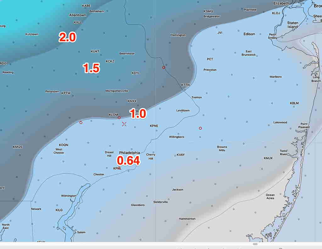
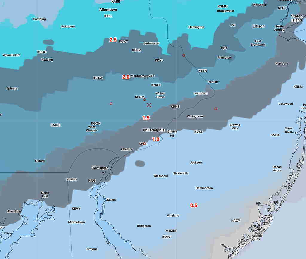
Update Fri 04:30 PM — NBM data back online.  Here’s the latest median snow/sleet accumulation for Saturday 7PM:

National Blend of Models (NBM) median snow/sleet 7PM Saturday.   Click for larger image.

… from earlier this afternoon—

An interesting winter mixed precipitation type scenario setting up for Saturday. There are differences between the short range regional high resolution models and global models.

Most models have snow starting here about 10AM-12 noon. with some intermittent light snow flurries possible earlier.  (The Canadian models have a later start)  Precipitation ends about 7-9 PM Saturday.

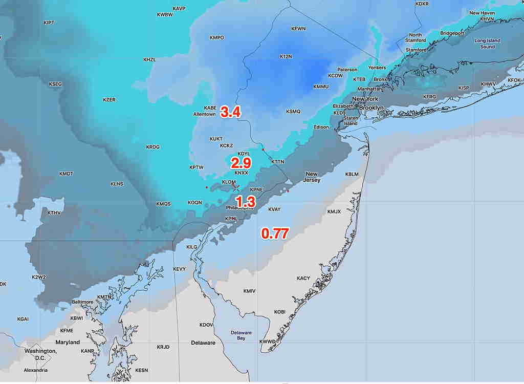
As for snow/sleet accumulation totals:
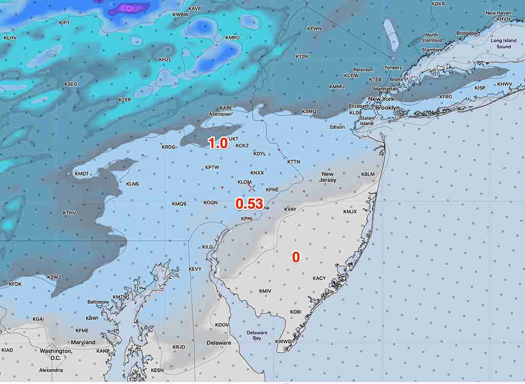
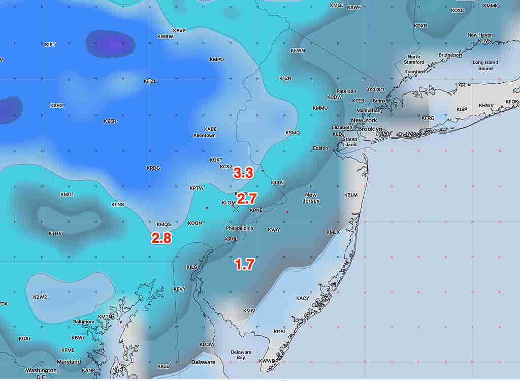
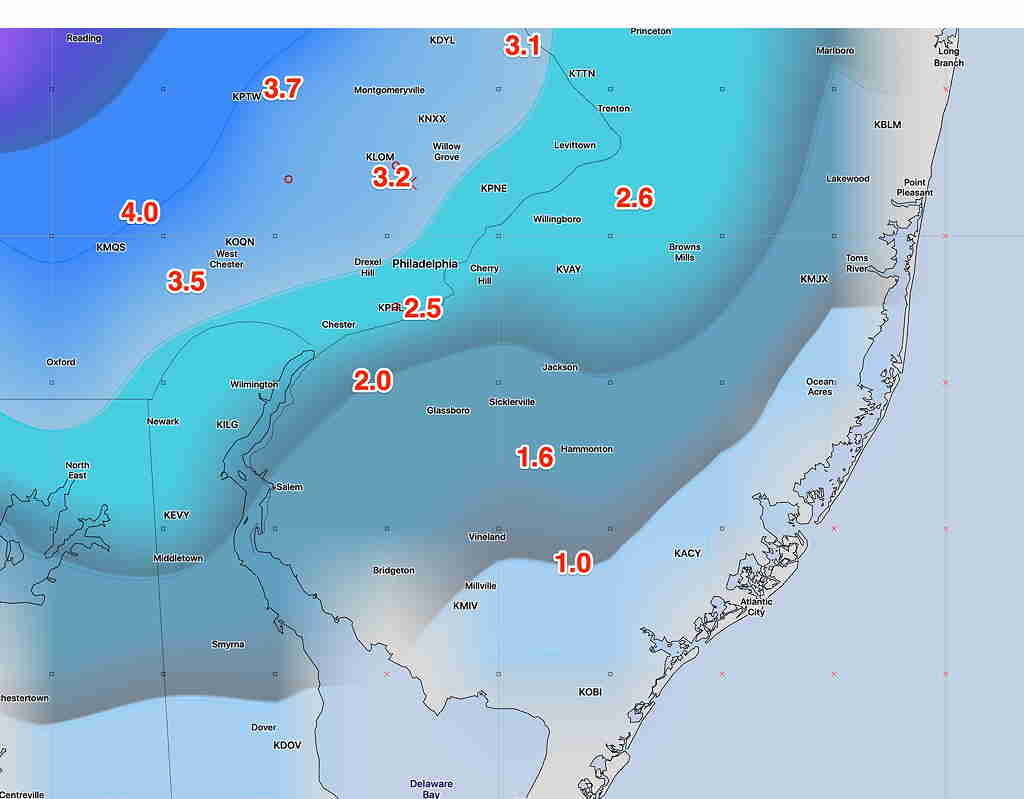
Today’s global models (GFS CMC-GDPS amd ECMWF) have all increased their snow/sleet totals somewhat from previous days.  Here’s the latest GFS snow/sleet totals:

GFS Snow-sleet depth totals for 6 PM Saturday. Click for larger image

Meanwhile, the NAM and higher resolution models have very different predictions due to a warmer profile at about 6000 feet.

NAM Snow totals Saturday 6 PM

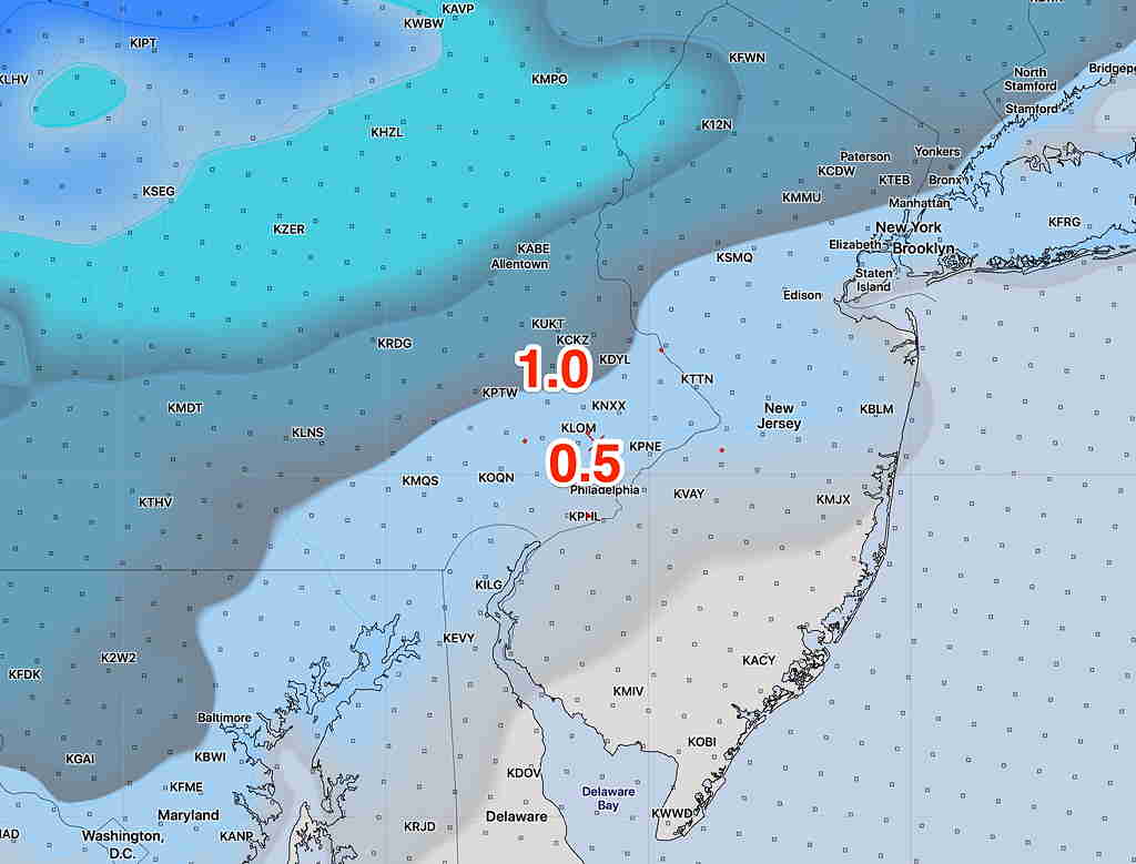
Both sets of models have similar QPF values- total precip falling as water. (0.45-0.55 inches water.)

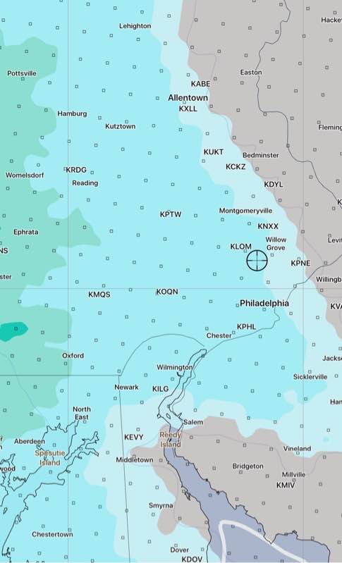
However,  the NAM and other high resolution models have sleet as the predominant PTYPE (pink) by 3 PM:

NAM 3 PM PTYPE   Sleet in pink, freezing rain red

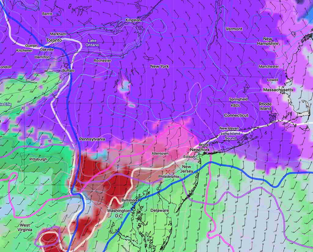
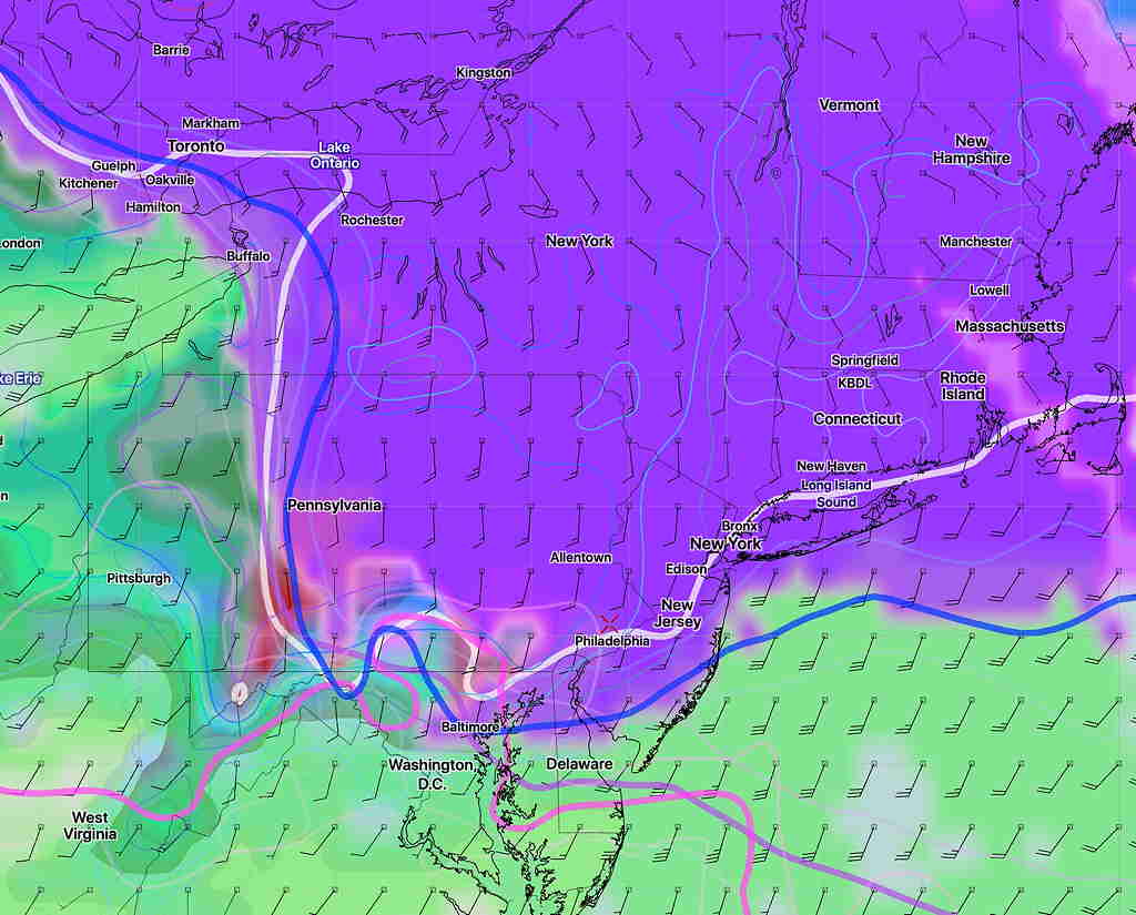
The GFS doesn’t have the influx of warm air at and above 6000 feet, maintaining snow as the principal precipitation type (Purple) at 3PM:

GFS PTYPE 3 PM (shading) and critical 3 D thermal profiles  (lines)

It’s funny, in past years, I put heavy emphasis on the NAM model thermal profiles.

However, the new GFS (new last year) has outperformed the NAM for storm tracks this year.   We’re going to find out whether it’s better with thermal profiles.

I think the reality will be somewhere in the middle- an average of the GFS and NAM above.  I’ll be checking again later this evening.

SATURDAY FORECAST UPDATE

I wanted to do an early update, but the new GFS, Canadian and European models aren’t yet out.

Snow starts between 10AM -12 noon.  (Some models have some snow showers earlier, some start later.)

Whatever is falling ends about 7-9 PM Saturday evening.

The short range models have continued their trend of a quicker changeover to sleet with less snow/sleet accumulation. The latest NAM snow/sleet depth forecast captures this:

NAM Snow Depth forecast for 5 PM Saturday  (click for large image)

Last night’s GFS, CMC and ECMWF had somewhat increased their sleet/snow accumulations totals, keeping colder temps longer in the event.  They are in line with the NBM forecast from last night.

I’ll update early afternoon and again this evening.

(Some data still not available from NOAA- NCEP)

SATURDAY STORM UPDATE

We’ve moved into the forecast range of some of the shorter-range, higher resolution models.  Sometimes, things fall into the category of “too much information”; this may be one of them.

Start time varies by model.  I still think snow starts between 10 and 12 PM, with some earlier patches of flurries possible.  Some models have it starting about 12-1.

Mixing or changing to sleet  possible as early as 3 PM.   As mentioned yesterday, dynamic cooling may bring the snow back in the picture if precip rates increase enough.

Snow/sleet/rain ends early evening.

For snow totals, this how things are sorting out—

The shorter range models (NAM and NAMNEST) have it warmer aloft, have less total precip  in their afternoon runs and more sleet.  Here’s their latest snow totals at 6 PM Saturday:

NAM NEST Snow totals


More consistent on the higher range has been the GFS model, shown below:

GFS Snow Depth totals 6 PM Saturday


The Canadian is closer to the GFS, the European model is closer to the NAM.

So, let’s turn to the National Blend of Models (NBM).  Here’s the current blended forecast:

NBM Snow Depth forecast

The NBM is my current choice for snow totals with this storm.


Just an aside:  There are problems currently with NOAA weather data centers right now:  Here’s a message that was sent out earlier:

“NOMADS users,

We are experiencing a critical failure in one of our data centers that is forcing us to shut down NOMADS entirely. FTPPRD will still be accessible for both FTP and HTTPS access, but full file download from nomads.ncep.noaa.gov as well as grib filter and openDAP services will be down.

We have no ETR at this time and will send frequent updates on status.”
So weather data access has been slow and limited this afternoon. My favorite version of the NBM model has been totally shut down.