Category Archives: Winter Weather

SNOWSTORM UPDATE

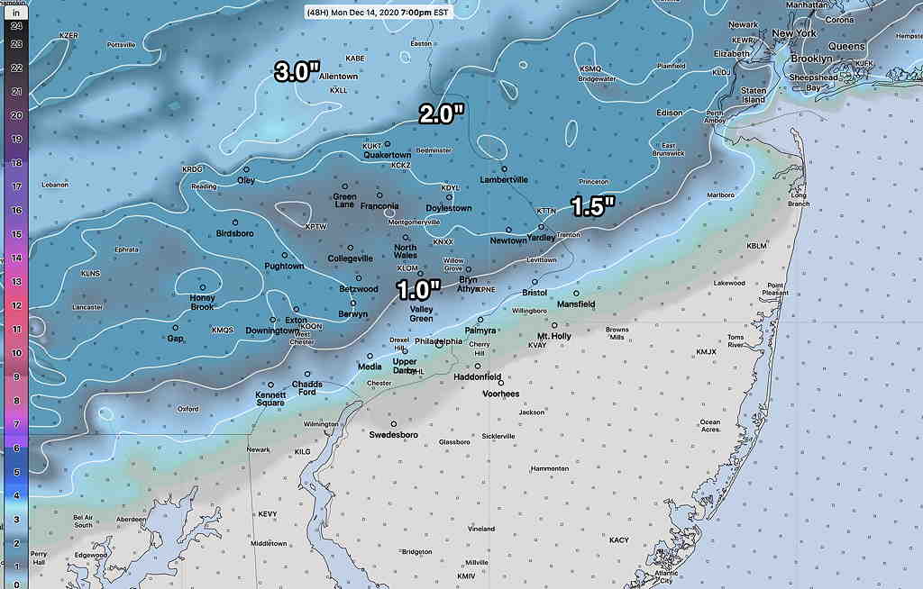
Here’s the latest information about the upcoming snowstorm for the Philadelphia area.   The timing of the storm has come within the forecast range of the high resolution models.  

Here is the current timing based on the latest HRRR (High Resolution Rapid Update) model— snow starts in our area, from southwest to northeast about 12-3 PM Wednesday.  Heaviest snow and mixed precipitation during the evening hours Wednesday.  Snow ends about 4 AM Thursday morning.

There’s still some uncertainty about warm area mixing in at certain levels, changing the snow to a mix at times and reducing total accumulations.  The snow accumulations for several models has reduced a bit in the immediate PHL area, despite the fact that the snow-water equivalent has remained the same. This indicates some mixed precipitation will reduce snow accumulations.

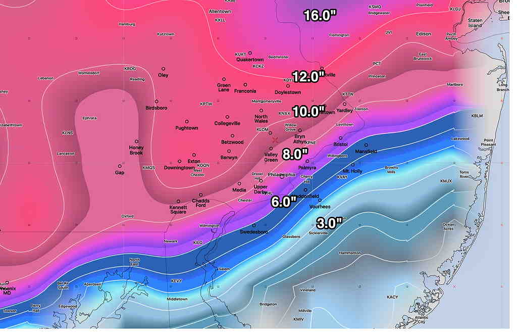
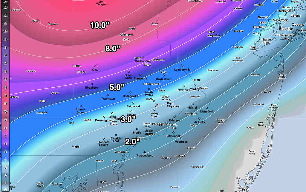
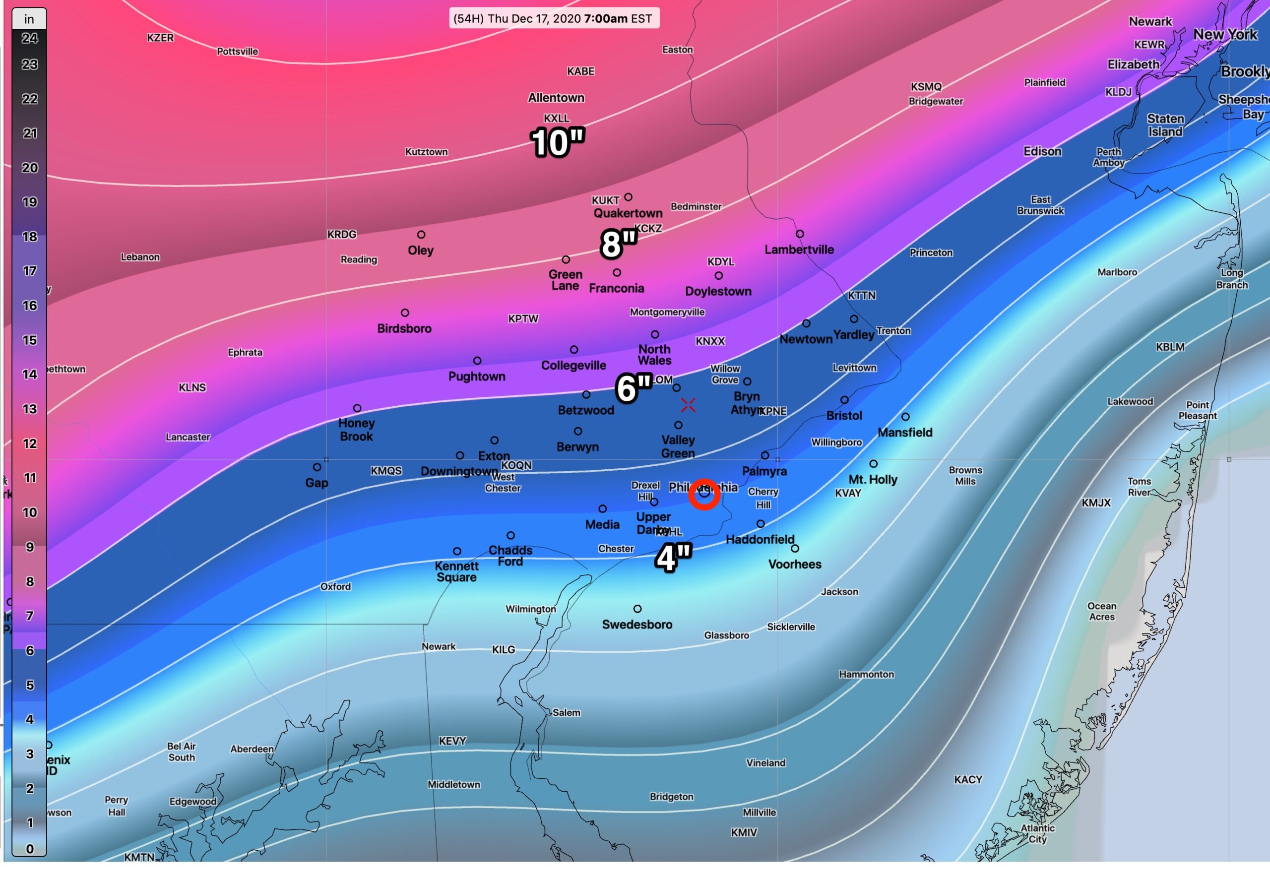
Here’s the current latest HRRR snow totals—

HRRR model Snow accumulation forecast by 7 AM Thursday (Click on image for a larger view.)


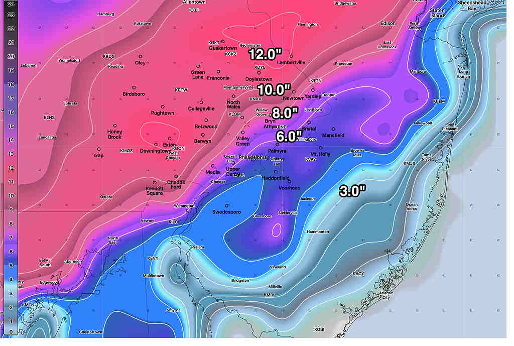
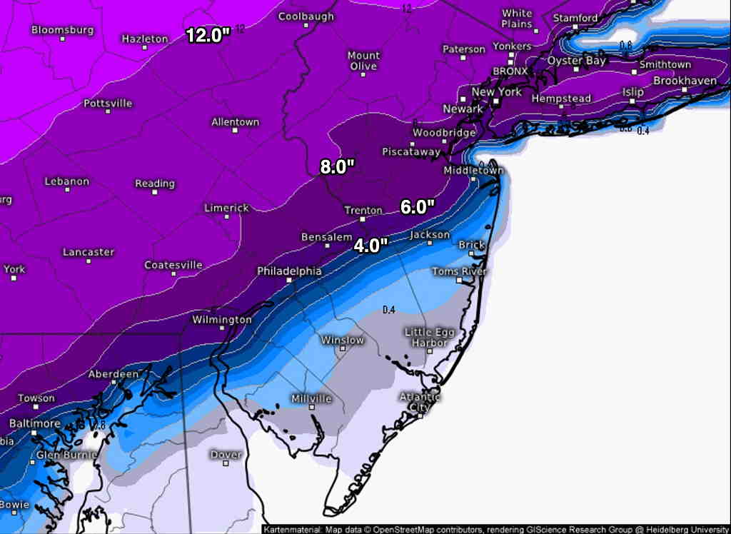
Here are some other perspectives: The German ICON model is somewhat similar—

German ICON model Snow forecast (Click on image for a larger view.)

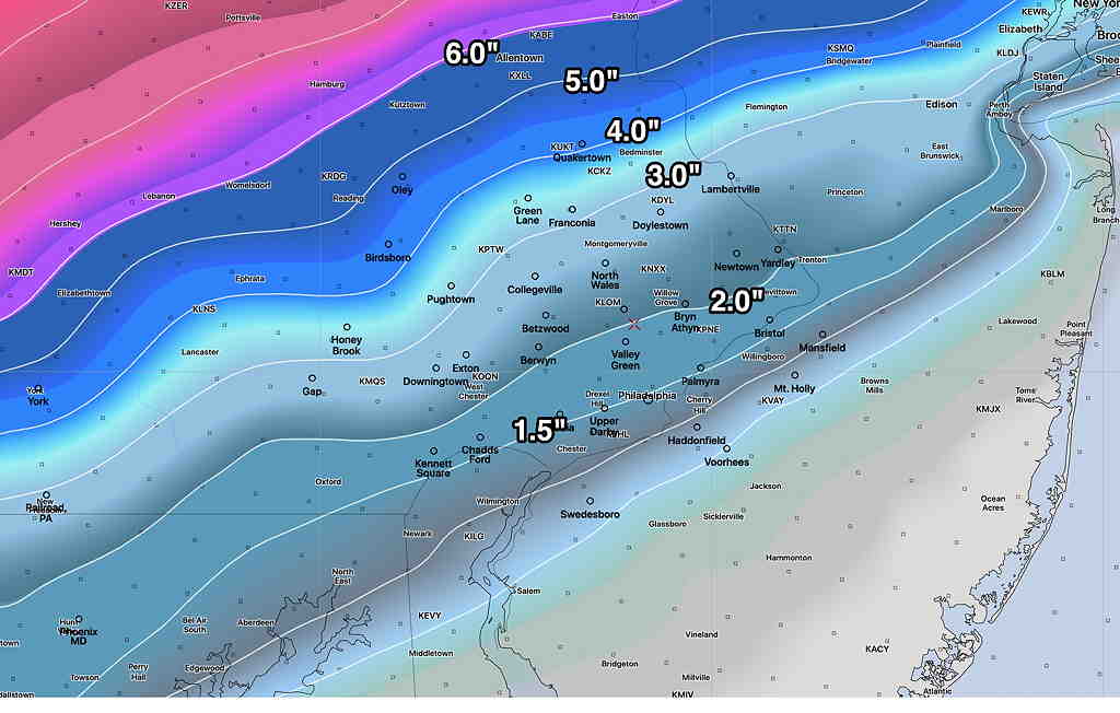
The European Model (ECMWF), which is run only twice daily.  This is the latest forecast from last night (the new model will be available about 2 PM EST today)  shows somewhat less—

ECMWF Snow forecast  (Click on image for a larger view.)

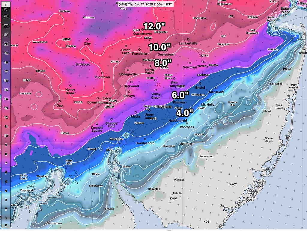
The NAM just available continues to show the storm a bit further north, introducing warm air into the mix, reducing snow totals from the above values.

Those of you who have been long-time followers of this blog know that I’ve been a big fan of the NAM for snowstorms, but I never used its built-in snow depth forecasts, instead doing the calculation based on FOUS QPF, thickness and temperature data. By those measures, the above forecasts from the above HRRR look pretty good, maybe even on the low side.

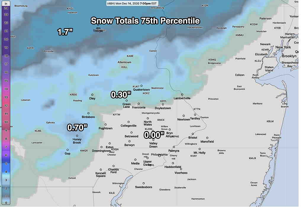
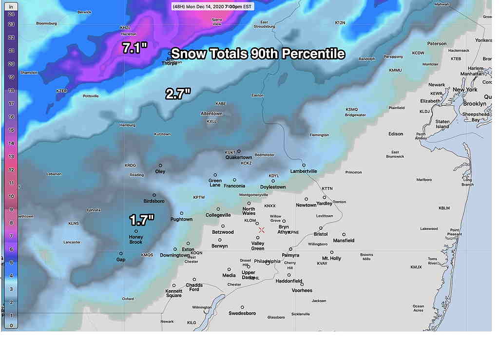
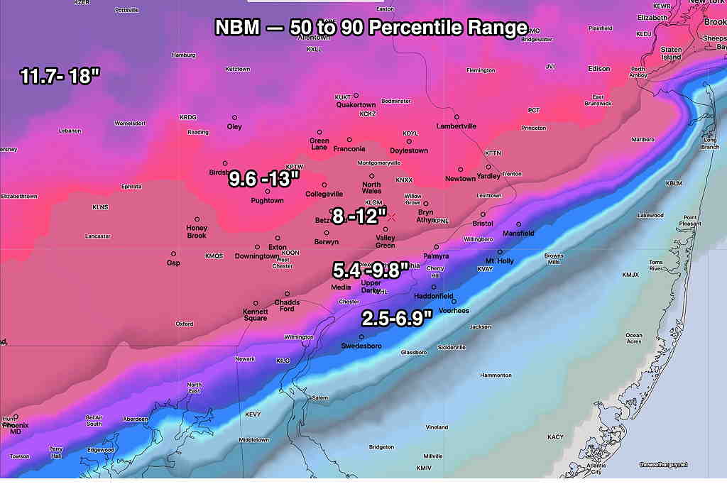
So, I think with current model advancements, I’m going to hang my hat on the new NBM model and use the 50-90 Percentiles as the best forecast—

NBM 50 and 90 Percentile range Snowfall forecast (Click on image for a larger view.)

The next big updates in models will be this evening. The NBM 00z forecast becomes available at 8:30 PM EST. The HRRR, NAM between 8:30PM and 10 PM. Stay tuned for more updates…

Tue 10:47 AM Update — Some new models coming in suggest that the lower range of snow (50 percentile numbers above) may be the better choice.

WEDNESDAY – THURSDAY SNOW UPDATE

The latest models have become available for the snowstorm forecast for Wednesday afternoon into early Thursday morning.  Current timing is that snow starts about 2 PM Wednesday and ends around daybreak Thursday.  A significant nor’easter is forecast by most models.   The latest GFS snow totals forecast is also representative of the Canadian and ICON models—

GFS snow totals by Thursday morning.

However, there has been a re-emergence of a complication that I had mentioned yesterday. The NAM, SREF and NAM-NEST have a wedge of warm air being drawn in at 3000 feet during the peak of the storm Wednesday evening, changing the snow to sleet or a rain-snow mix—

NAM model at 6 PM Wednesday.  Lavender line (white arrows) shows freezing temperature at 3000 feet north of the Philadelphia area.  This would result in a changeover to sleet and rain during the storm peak. (Click on image for a larger view.)

As a result, the NAM and NAM-NEST show snow totals much lower—

NAM Snow totals Thursday morning  (Click on image for a larger view.)

So there’s some real differences with the higher resolution models (that are just coming into forecast range) and the GFS, Canadian and current ICON models.

Most higher resolution models only forecast 48-60 hours in advance. They will begin to come into forecast range with this evening’s model runs and certainly by tomorrow late morning. Stay tuned.

MONDAY SNOW UPDATE


So, this all started a few days ago when the soon-to-be released GFS model version 16.0 had predicted some light non-accumulating snow for Monday when the other models were predicting all rain.

Since that time several (but not all) models have jumped on the light snow band wagon. There’s still much uncertainty about the temperature profiles on Monday. Many models show a change over to snow, but not all show accumulating snow in the immediate Philadelphia area Monday.

At this point in time, it’s best to move over to the new National Blend of Models (NBM) which runs hourly and statistically blends about 20 different models (including the much-touted European Model) with a complex statistical weighting based on each model’s accuracy over the immediate previous six hours.

One of the features of the newly release NBM version 4.0 is the statistical handling of many parameters, including snowfall.

The most recent NBM model shows rather unimpressive snow totals for most of us on Monday. (Again, it’s a blend of models. Current models aren’t all on-board with snow accumulation.)

So let’s try something new—snow prediction via statistical percentiles.

Here’s the total snowfall predicted in the 75th percentile (75% show this amount or less)—

NBM 75th percentile  (Click on image for a larger view.)

Here’s the total snowfall predicted in the 90th percentile (90% show this amount or less)—

NBM 90th percentile snowfall (Click on image for a larger view.)

As you can see, most of the immediate PHL area won’t see any accumulation on Monday, although precipitation will fall as rain changing to snow.

In contrast, let’s look at the very latest high resolution NAM-NEST model forecast—

Tonight’s NAM-NEST snowfall forecast for Monday  (Click on image for a larger view.)

I would go with the NBM model, somewhere between the 75th and 90th percentile amounts above.


As for Thursday, the already highly-advertised snowstorm still continues to threaten. I’ll be covering this during the week. Food for thought is the current ICON model—

German ICON model snow forecast  (Click on image for a larger view.)

For a change of pace, also of interest is the Canadian Global model—

Canadian Global GDPS Snow forecast for Thursday

The ICON model, which I recently found access to, has been pretty good in recent months. The Canadian model tends to over-state snowfall in recent storms last year.

Stay tuned.