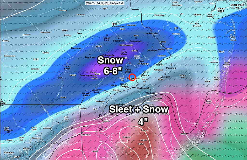
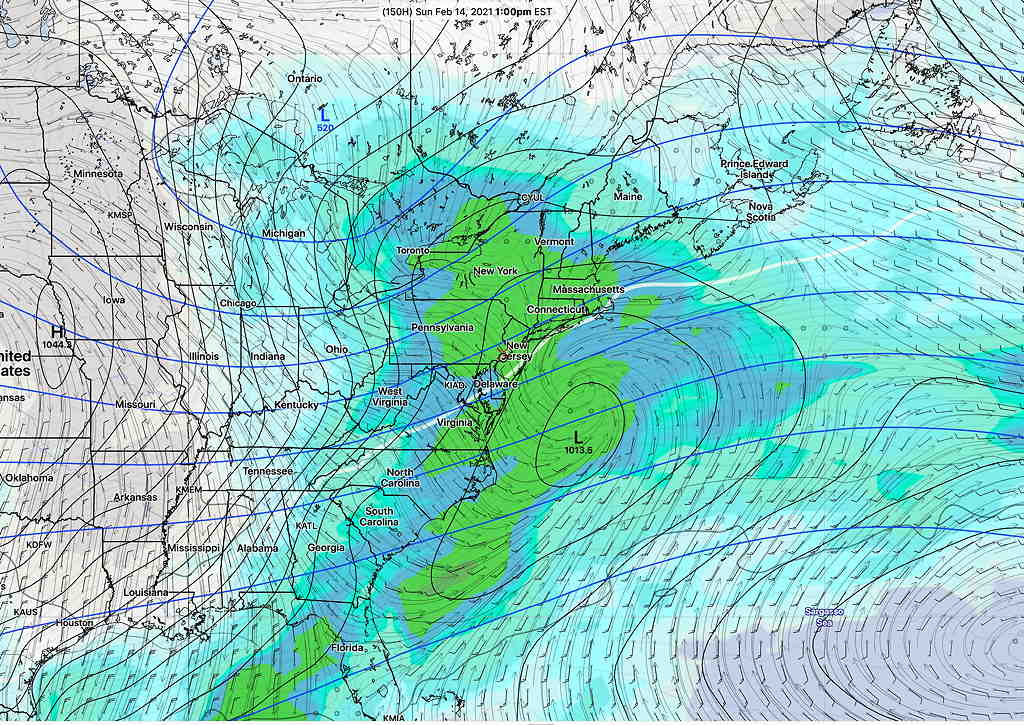
Forecast Updated Tue 9:02 AM — A quick update. From the latest GFS model v 16 (scheduled to replace the existing GFS model and become the operational GFS on March 16th) A picture’s worth a thousand words—
Latest GFS version 16 Snow water equivalence with superimposed PTYPE. Snow accumulation by 8 PM Thursday and predominant precipitation type by area. (The current, operation GFS version 15.3 has slightly higher snow totals. ) We know things will change and in recent storms, the GFS has over-predicted snow.
Snow starts between 6 and 9 AM Thursday.
Next update early evening Tuesday. Stay tuned.
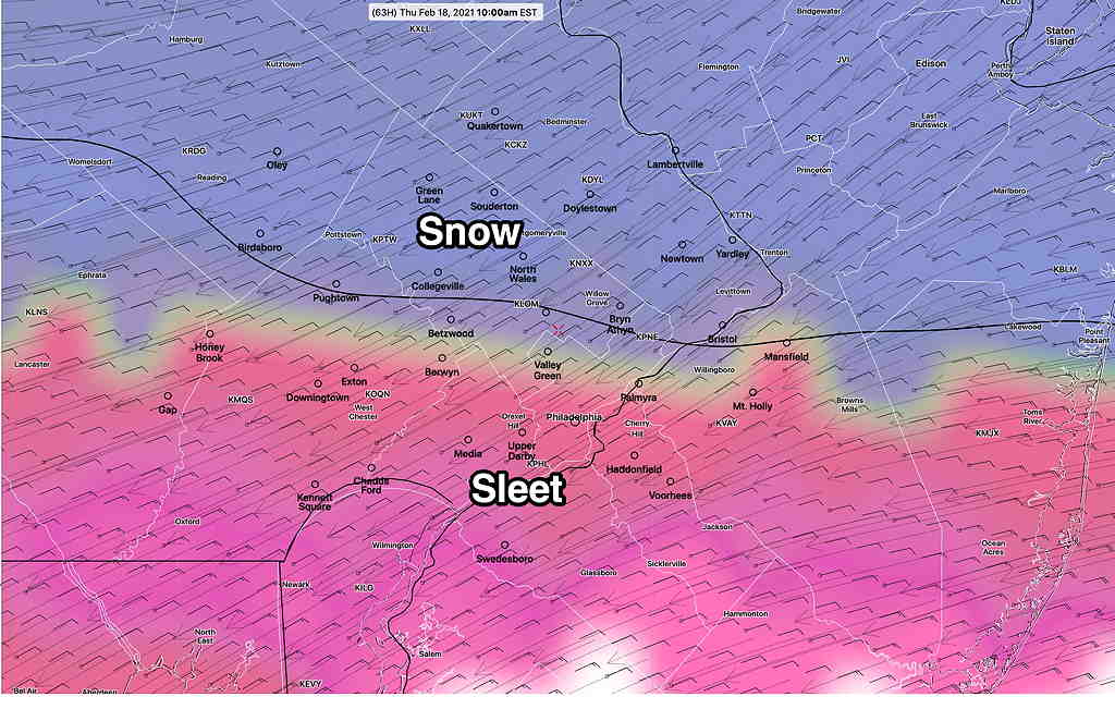
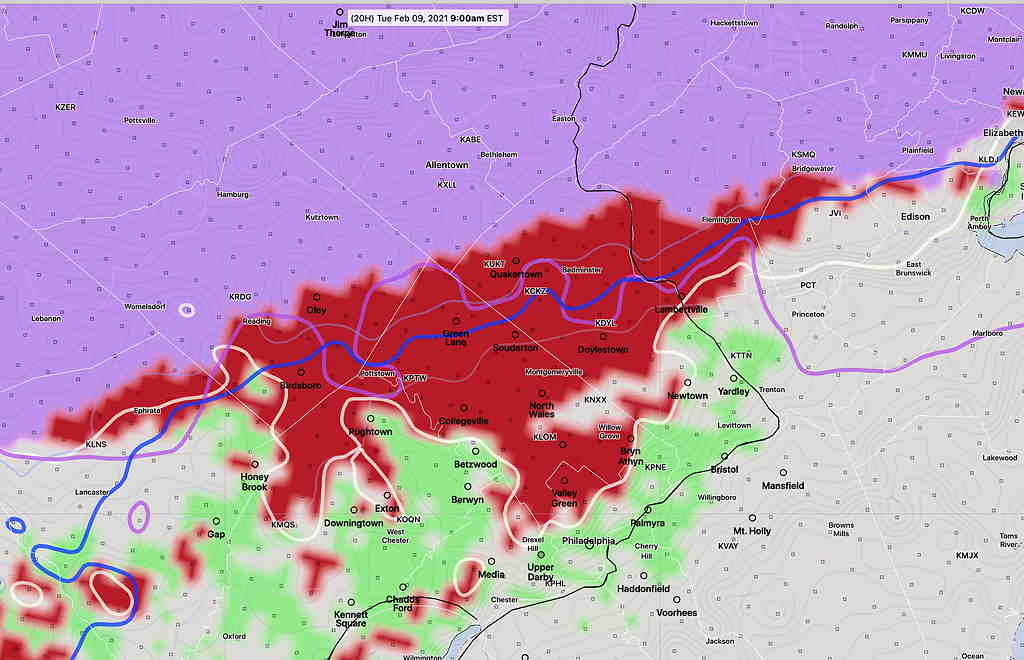
Mon 09:59 PM Update — Tonight’s NAM has joined the rest of the models and now has snow at the start by 6-7 AM with 3-6 inches from the city north before the snow changes to sleet about 10AM – 1 PM.
NAM PTYPE Thursday 10AM (Click on image for a larger view.)
Expect further changes.
From this afternoon…
A complex winter storm system will approach on Thursday morning and develop a secondary coastal low later Thursday. As usual, there’s considerable spread regarding the precipitation type and amounts.
I’m going to start with my own mantra—
“Never ignore the NAM model”
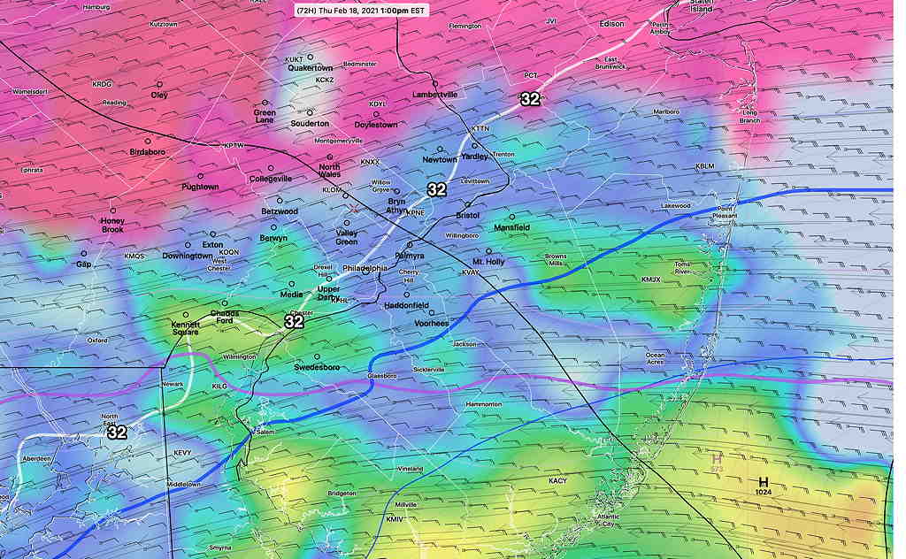
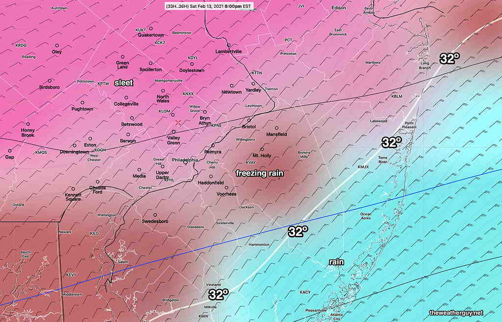
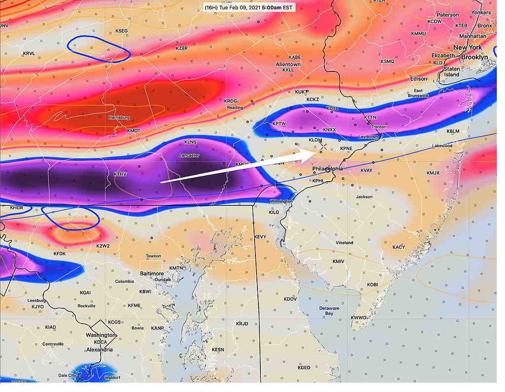
While the current GFS, ICON and Canadian GEM have about 3-5 inches of snow, starting about 7-9 AM Thursday morning , the NAM has it starting as all sleet, little snow, and changing to sleet- freezing rain by about 1PM—
NAM model showing freezing rain and sleet to our north (magenta) by 1 PM. Notice the position of the 32º freezing line (white) just running through Philadelphia. The green-blue-yellow is ‘simulated radar’ rain or freezing rain. (Click on image for a larger view.)
The GFS has it starting as snow, but changing to sleet and freezing rain much later in the day Thursday. The GFS shows 5+ inches of snow.
If we follow the NAM mantra, the GFS is over-predicting the snow.
The Friday time frame is beyond the forecast range (84 hours) of the latest NAM, but the GFS shows a secondary coastal low development with continuation of precipitation through Thursday night. The GFS doesn’t currently show much snow at the back end of the storm.
Forecast Updated Sat 5:21 PM —  The light freezing rain will continue through this evening with a heavier batch moving through about 10 PM.  Precip tapers off towards morning Sunday.


For Sunday, just cloudy in the morning and the HRRR has some brightening skies in the afternoon.

Another batch of wintry precipitation midday Monday, likely in the freezing rain/sleet variety that will change to heavy rain by Monday night.  Stay tuned for more updates.
Forecast Updated Fri 9:07 PM —
Tonight’s (00z) models are just becoming available. The HRRR is showing a light coating of snow during the late morning Saturday before a changeover to light sleet and freezing rain. The 00z Model Blend has this happening early to mid morning, while most models have some light snow/sleet/freezing rain between 11 AM and 2 PM.
The SREF shows all light sleet/freezing rain with no snow. A few weeks ago, the SREF was the only model to get the precip type (PTYPE) correct.
All models have only 0.05 to 0.10 inches water equivalent, so we’re talking about light precip. Nonetheless, if it’s freezing rain, it can be a travel issue, especially when it continues after sunset. (We’re getting to the point in the calendar year where higher sun angle and solar “insolation” through clouds can help melt precip on dark asphalt surfaces.)
Freezing precip ends around daybreak Sunday. Sunday still looks very cloudy and somewhat milder. High temp 37.8º ± 1.7º
Added Fri 10:35 PM : Tonight’s NAM and HIRESW-ARW have some breaks of sun midday Sunday.
We may luck out with the storm mentioned in my earlier post for Monday into Tuesday. Some models are showing it will be mostly rain here.
posted Friday afternoon…
Cold surface temperatures with warmer flow at 3000 feet will be a setup for freezing rain and sleet Saturday into Saturday night. Another light freezing rain/sleet/snow event Sunday night and a more significant storm for Monday night into Tuesday!
Low pressure moving off to the south and a front to our west will maintain sub-freezing surface conditions, but the wind flow above 3000 feet will keep temperatures too warm for snow on Saturday.
SREF Short Range Ensemble Forecast For Saturday 1 PM Low pressure moving off to the south and a front to our west will maintain sub-freezing surface conditions, but the wind flow above 3000 feet will keep temperatures too warm for snow on Saturday. (Click on image for a larger view.)
Saturday:
Cloudy early morning with darker, lower clouds by afternoon.
Very light precipitation is predicted by most models (a few hundredths of an inch of water), but it will fall as freezing rain and sleet for the immediate Philadelphia area.
The first period of precip expected late morning and early afternoon. Another period of light mostly freezing rain/sleet later afternoon and evening.
SREF Precipitation type 8 PM Saturday (Click on image for a larger view.)
Slippery conditions are ikely with ice accumulation Saturday evening and night.
High temperature Saturday 27.7º ± 2.2º Blue Bell.
Sunday:
Sunday starts with the same dark, low cloudiness, but the low level clouds will lift to mostly mid-level cloudiness by the afternoon. No sun expected. We should reach a high of 36º± 1.7º, which could be our high temperature for the week.
Forecast uncertainties: There’s a range of values for the quantity of precipitation falling (QPF) as a mix for Saturday into Saturday night. While most models have things on the very light side, freezing rain can be very problematic if large QPF values allow buildup on power lines and tree branches.
Additional light freezing rain Sunday night!
A significant storm is expected Monday night into Tuesday with more sleet, freezing rain, possibly changing to snow.
Forecast Updated Tue 10:25 PM — Tonight’s models have begun to come in. The trend is for both Wednesday night’s impulse and the second one to take an increasingly southern track. Areas from Philadephia and north will have 1-2 “, but areas south (southern Delaware, Chester counties and southern NJ) may have 2-4 inches. The second disturbance later Thursday into Friday may miss us entirely. Stay tuned .
Forecast Updated Tue 5:53 PM — The setup described yesterday continues to evolve into a complex and uncertain forecast as several impulses develop from a plunge of cold arctic air. The first impulse will move through late Wednesday evening into Thursday morning. Snow totals of about 3 inches are possible by noontime Thursday morning, but the snow may continue into Friday as the second impulse moves in.
The forecast beyond noontime Thursday becomes unclear.
Some models have moved the track of this second impulse on Friday to our south; the second impulse may miss us.
SREF forecast Thursday morning showing the two impulses. (Click on image for a larger view.)
It’s unclear if these impulses will arrive as discrete, separate systems or whether they will be diffuse less potent and more disorganized.
The model blend (NBM) has snowfall from Thursday into Friday with periods of heavier snow Thursday and again on Friday. There is much uncertainty with these multiple systems.
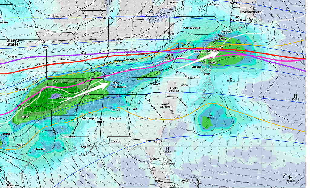
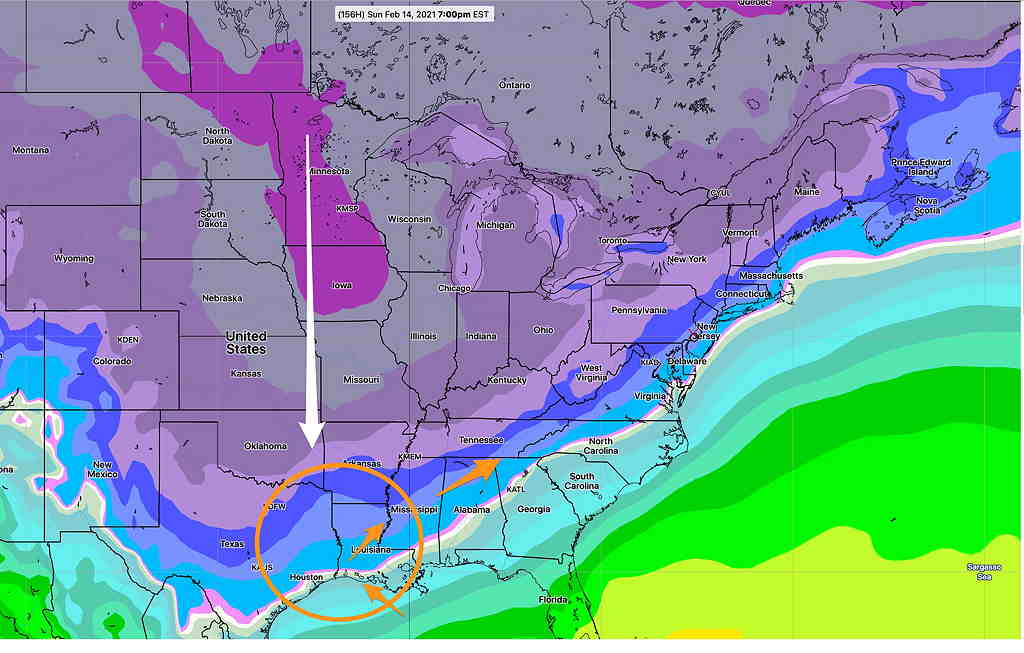
The GEFS continues to forecast a nor’easter for us late Saturday into Sunday
GEFS showing plunge of cold air (blue arrow) and track of coastal low (white arrow) (Click on image for a larger view.)
Stay tuned…
Forecast Updated Tue 9:03 AM — The very light snow/freezing rain that had been expected early today is likely to stay to our north this morning. The areas of positive vorticity as depicted on yesterday’s map will be the only areas getting any precip from this weak disturbance.
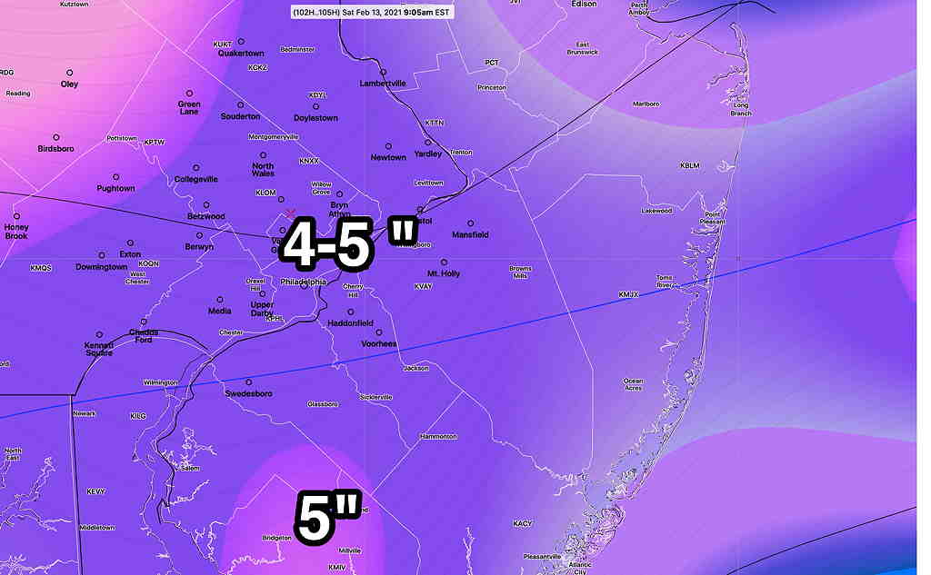
The latest ICON model shows a more significant snowfall for late Wednesday through Thursday with a generalized 4-5 inches of snow total by Friday morning
ICON Snow Forecast for late Wednesday through Thursday (Friday morning totals) (Click on image for a larger view.)
We all know that these numbers are not worth that much at this point in time, but it’s useful to know that significantly more snow is possible.
Stay tuned
From Monday at 5:54 PM…
Cold air that had been sequestered in Canada for much of January has begun to plunge into the continental US. The plunge of cold air is such that it will push the jet stream south, providing a boundary and track to bring stormy weather to the Philadelphia area over the next week or so.
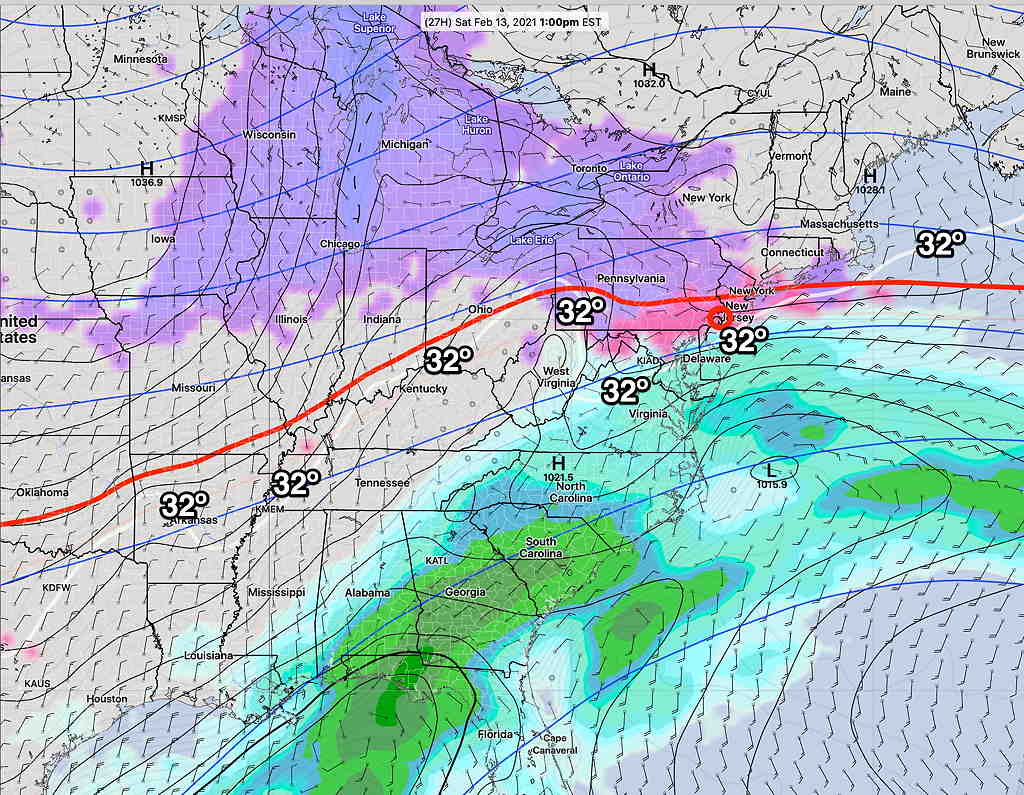
GEFS Temperature forecast for Sunday showing region of likely storm development (Click on image for a larger view.)
As this week progresses, several weaker disturbances will affect our area as this boundary develops into a highly amplified jet flow. Two relatively weak disturbances will affect us prior to Sunday’s storm.
Tuesday
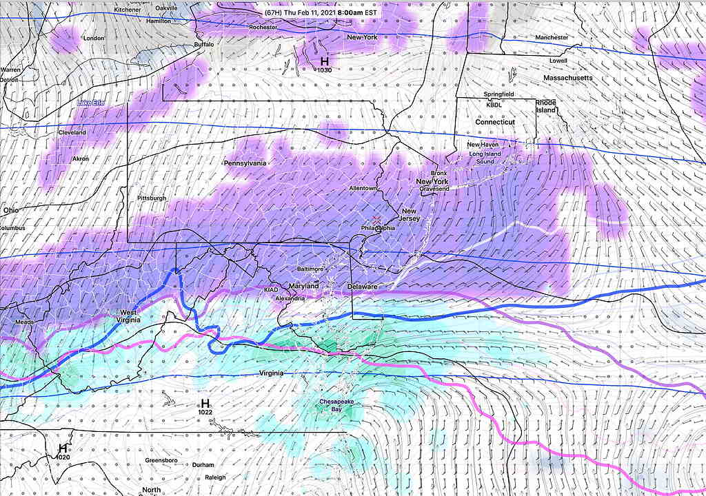
A mid-level disturbance (areas of “vorticity” at 14,000 feet and above) will move through in the early morning Tuesday. There’s hardly a surface low pressure development with this disturbance, but it shows as vorticity maxima—
NAM 700 mb and 500 mb absolute vorticity Tuesday 6 AM. We’ll be in the area of negative vorticity (blue and violet), limiting the precipitation, but areas to our north will have significantly more precip.(Click on image for a larger view.)
Though moisture is limited, there will be enough lift to cause precipitation. The precipitation will move in prior to temperatures warming up. There’s a very good chance of very light snow and very light freezing rain, maybe sleet, during the period 6 AM -10 AM Tuesday morning.
NAM-NEST PTYPE 9 AM Tuesday (red =freezing rain) (Click on image for a larger view.)
Most models are on-board with this forecast, but be advised that in recent storms, the models have been too cold at the surface and freezing rain hasn’t materialized. This time, both the GFS and NAM model groups have the freezing line just south of Philadelphia at the start. Accumulations won’t be an issue here in Philadelphia, but slippery conditions are likely. (Total QPF is about 0.10 inches water)
Wednesday Night into Thursday
A similar setup is expected to move in late Wednesday into Thursday. This disturbance will have more moisture and is expected to be stronger than Tuesday’s with maximum lift area over the PHL area. The Canadian models have been consistent moving this in Wednesday afternoon, but most other models keep the onset timing early Wednesday evening through Thursday morning. Current snow forecasts range from 1-3 inches.
GFS forecast 8 AM Thursday morning (Click on image for a larger view.)
Sunday
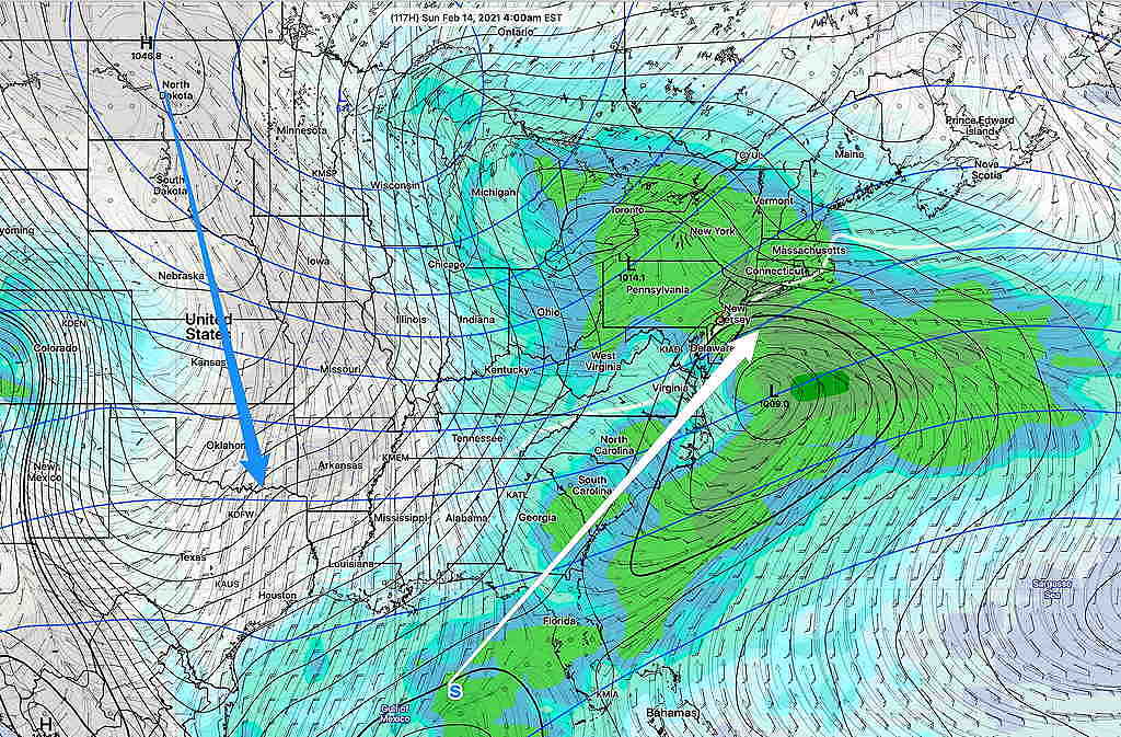
A more significant coastal storm is expect to affect us on Sunday, the result of the plunge of cold air and the resultant amplified jet configuration, as mentioned at the beginning of this post. No details right now, but significant snow is possible. Some models have this storm approaching as early Saturday evening.
GEFS Surface Forecast Sunday 1 PM (White line is near ground level freezing isotherm) (Click on image for a larger view.)