Category Archives: Winter Storm Outlook

QUICK STORM UPDATE- TUES 9:30 AM

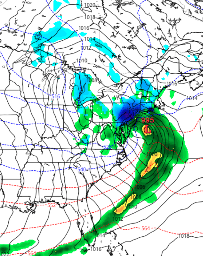
At work…not much time, but a quick update for the snowstorm in Philly tomorrow.  The latest NAM has become available.  QPF values, somewhat less, still more than 1.09 inches water in PHL.  Band of heavier snow north and west from Valley Forge and Northern Montgomery county and north.

Temperatures at critical levels may allow some mixed precip in PHL during the morning, but a changeover back to all snow in the afternoon.  Timing still on track as earlier posts have mentioned. Still going with 12 inches in PHL, less along the adjacent counties SE of PHL, 18 + in western and northern suburbs.    (As was the case with the last storm, this is accumulation POTENTIAL.  March snowstorms have their own thermal issues from solar insolation effects, reducing totals.)

A busy day at work for me….won’t have time for elaborate posts or evalution of other models until this evening.   The all important data becomes available about 9:15 PM and the 3D temperature profiles about 9:45 PM.


PHILLY SNOWSTORM UPDATE – MON 10 PM EDITION

Here’s the latest on the snowstorm expected Wednesday. Tonight’s NAM data along with this afternoon’s model runs show high continuity suggesting that this is likely to be a high confidence forecast.

Latest NAM has a QPF of 1.34 inches water for PHL, higher amounts north and west of Philadelphia. (Expect those numbers to change with each model run.  It’s the nature of weather prediction.)

NAM Forecast Wednesday 1pm. A little less intense than this afternoon’s NAM

Still a significant snowstorm, with snow totals 12-18 inches as a current best guess.

Snow starts as a wet mix between 7-10 pm Tuesday night but changes to snow overnight. Snow falls moderate to heavy after daybreak Wednesday , tapering off about 6pm.

I’ll try to update tomorrow morning about 9:15 am.

[su_note note_color=”#ebf2d9″]Tonight’s GFS has an almost identical QPF of 1.33 inches water. GFS has heavier snow earlier on Wednesday [/su_note]

PHILLY SNOWSTORM FORECAST UPDATE -6 PM MON

This afternoon’s model runs continue to show a major snowstorm for Philadelphia and its suburbs, especially north and west of I-95.

There isn’t much to add to my previous posts from earlier today.

The thermal profiles, especially the NAM, make this storm to be mostly snow.  Latest QPF values from the NAM is over 2.0 inches water! (24 inches of snow potential!). The GFS, as it almost always does, shows a lower QPF of about 1.0 inches ( 12 inches snow).

Usually in these situations, the NAM is overstating things, so for now, the average is 1.5 inches water.  At a 10-1 ratio (which may be too low), we’re still looking at a potential 18 inches.  With the thermal profiles getting colder Wednesday afternoon, the ratio will increase, so 18 inches might be conservative.  This looks like it could be a major snowstorm if these numbers hold up.

Timing: Snow or a mix of rain and snow starts about 9 PM Tuesday evening in PHL.  It will be light and may not accumulate much by morning, however, the storm will be forming before daybreak along the coast and snowfall will be increasing as temperatures in the upper atmosphere drops.  Snow ends early evening Wednesday.

So why haven’t the regular TV people been on the bandwagon sooner?  Not sure…I know they were heavily criticized for a poor forecast that impacted the Flower Show a few years ago.  So my guess is they’re treading lightly.