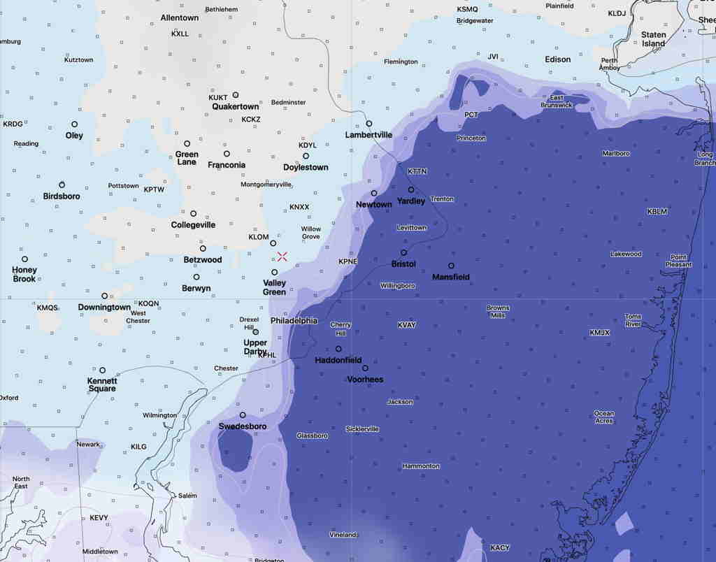
[su_note note_color=”#ffffff”]Updated Sun 09:44 AM — Latest HRRR keeps the sunshine to just west of the Delaware by 3 PM. The clouds hang tough east of that line.
HRRR (High Resolution Rapid Refresh) Model 3 PM low cloud cover forecast. Darker= more clouds (Click on image for a larger view.)
However, the experimental FV3-SAR has more extensive clearing and sunshine. [/su_note]
The forecast for Sunday hasn’t changed appreciably from what had been posted Friday evening. High pressure noses down from the northeast as an upper level ridge begins to build in.
The northeast flow from the high will bring us cloudiness and somewhat chilly temps for this time in May.
The high resolution models (NAM NEST and ARW MEM2) have some clearing after noontime. The experimental SAR model has considerable clearing during the early afternoon. The model blend (NBM) is more pessimistic about the cloud cover.
Sunday —
Low clouds in the morning
Clouds lift late morning and break for a mix of sun and clouds into the evening.
Winds NE 10 mph with gusts to 18. Gusts diminish in the afternoon.
High Temp 65.3º sd 3.3º (higher than average spread!)
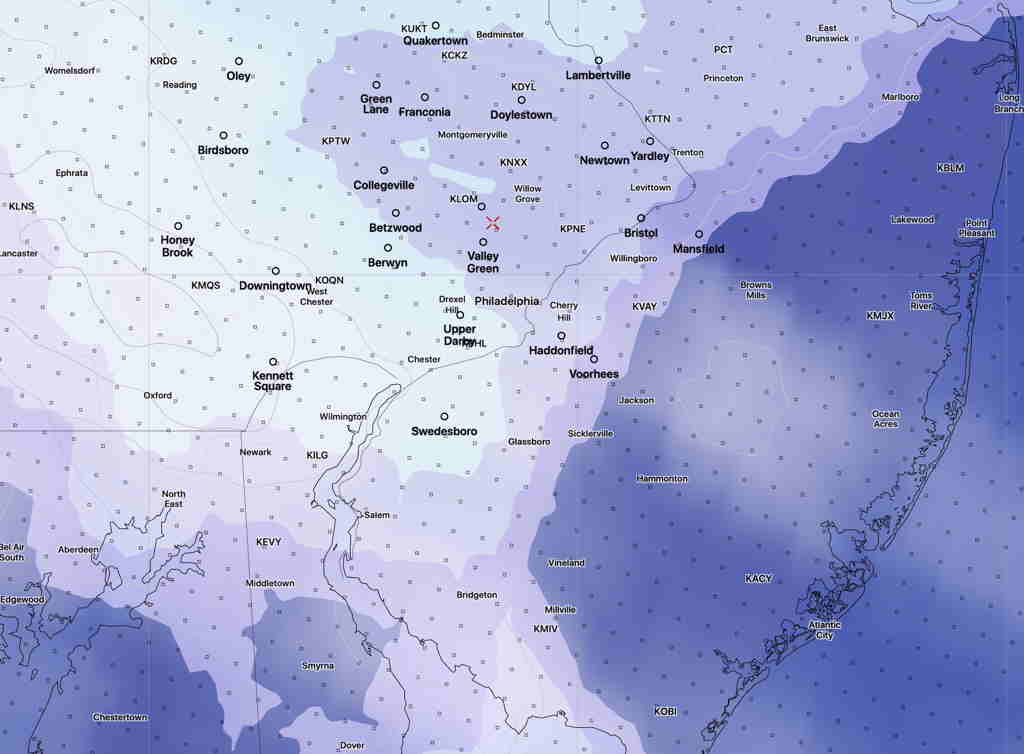
NAM NEST Cloud forecast 12 PM Sunday (Darker = more clouds) (Click on image for a larger view.)
A similar forecast for Monday… warmer in the mid 70s.
[su_note note_color=”#ffffff”]Updated Sun 09:09 AM —Cloud forecast has changed. Low clouds now should thin out later this morning. Sun though high clouds by noon. Becoming cloudy again mid afternoon. High 72.3º Some models have light showers moving in early evening. [/su_note]
Yesterday’s forecast for Sunday remains intact, based on the tonight’s short range models just becoming available. For several weeks now, I’ve been using the latest, pre-release versions of the HRRR and RAP models, scheduled to become operational on May 26th.
Sunday Forecast—
Sun through high cirrus clouds in the morning.
Increasingly cloudy from west to east after noontime.
Areas in NJ may be slow to cloud over.
Breaks of sun may briefly return late afternoon.
High temp NBM 71.1º sd 2.6º (high spread) HRRR 70.3º
Winds E—> SE light in the morning, then 10-15 mph
There’s increasing uncertainty about the forecast for Monday through Thursday. The coastal tropical system may become absorbed by the low pressure system in the Midwest. The models are having issues resolving where the heaviest rain will fall; some keep the rain substantially away from Philadelphia.
It’s a complex setup which is part of a blocking pattern, a closed upper low/surface low in the Midwest and a semi-tropical low off the SE coast. Will have to see how it plays out.
Brief Forecast Update Fri 7:53AM— Some slight changes in the forecast, based on the early morning model runs from (06z or 2AM EDT):
The precipitation moves in earlier today (Friday) with light sprinkles or showers in some locations in the morning and before noontime.
Heavier rain after 1 PM. The front moves through earlier, about 8:30 PM instead of 10PM. Less QPF than previously predicted with totals of about 0.60-0.70 inches water.
With more cold air and faster exit, just a slight chance of the snow flurries about 2 AM. (Who will see them at that time?)
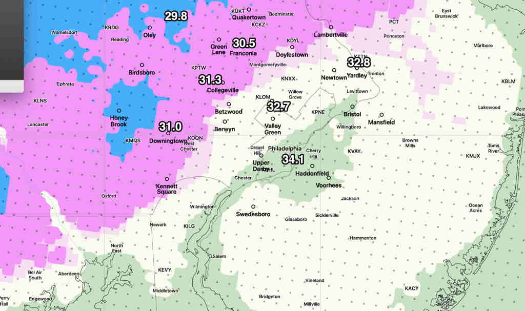
Updated Added Fri 09:08 AM — Mean low temperatures approach or below 32º from just west of the city and northwest around sunrise. (standard deviation is 1.5º to 2.2º’; think of it as ± 1.5 – 2.2º)
Model Blend (NBM) mean low temperatures before daybreak Saturday. (All have standard deviations of 1.5 to 2.0º) (Click image for a larger view.)
Uncertainty about the amount of cloud cover and instability showers on Saturday: the GFS and NAMNEST have sunshine becoming cloudy mid to late afternoon. High 48º sd 3.0º Windy to 30+ mph.
The new HIRESW-FV3 (pre-release version has significant periods of clouds and scattered instability sprinkles/(flurries?) throughout the day.