Category Archives: Philadelphia Weather Outlook

THIS WEEK’S WEATHER

Friday Forecast & Weekend Outlook

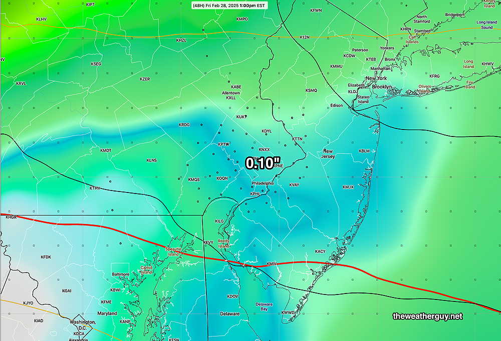
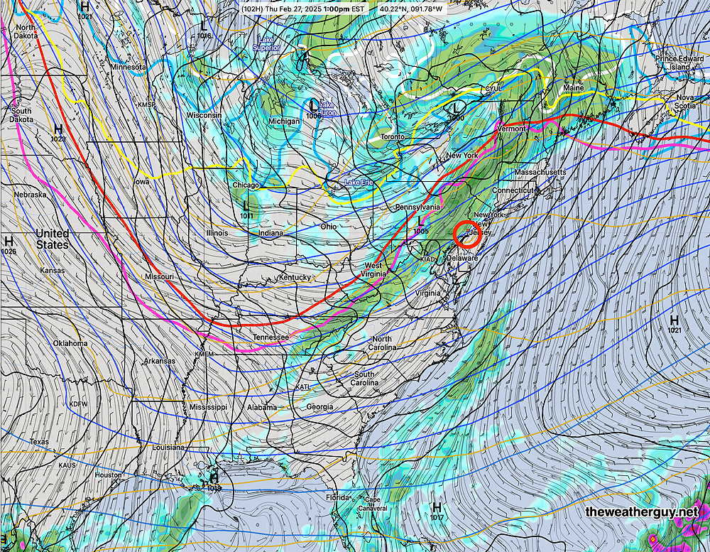
Posted Thursday 02/27/25 @ 5:30 PM — Today’s showers were just enough to keep the car washes busy. Total rainfall was as little as 0.03″ to 0.10″ just across the river in NJ.

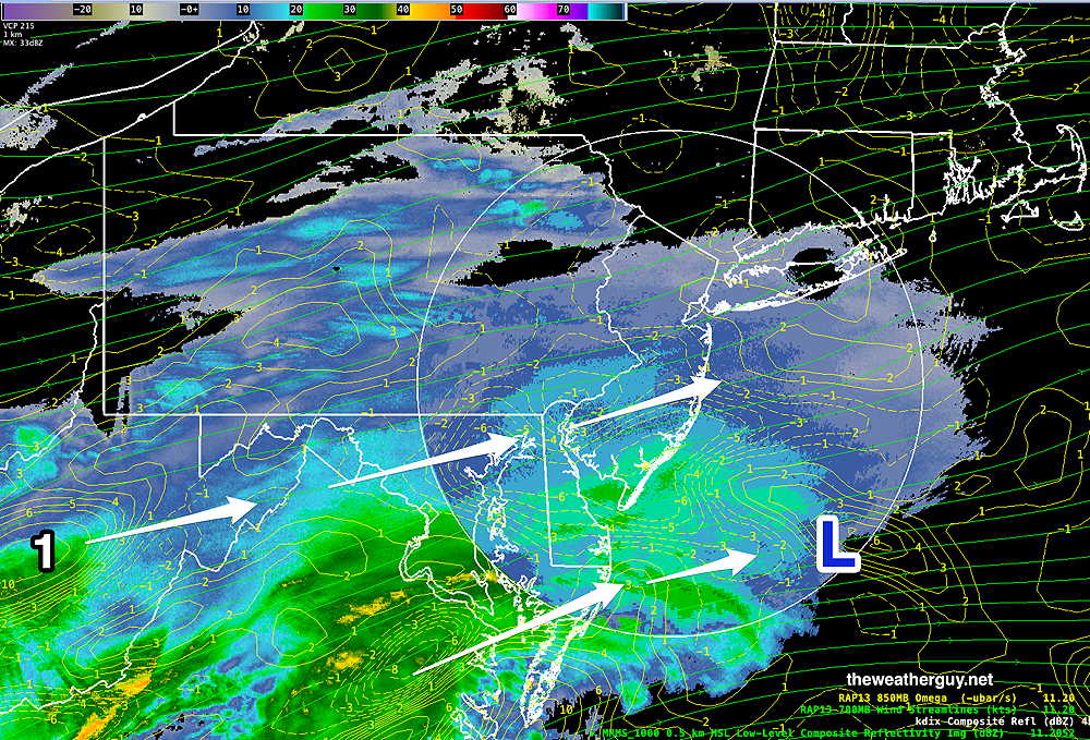
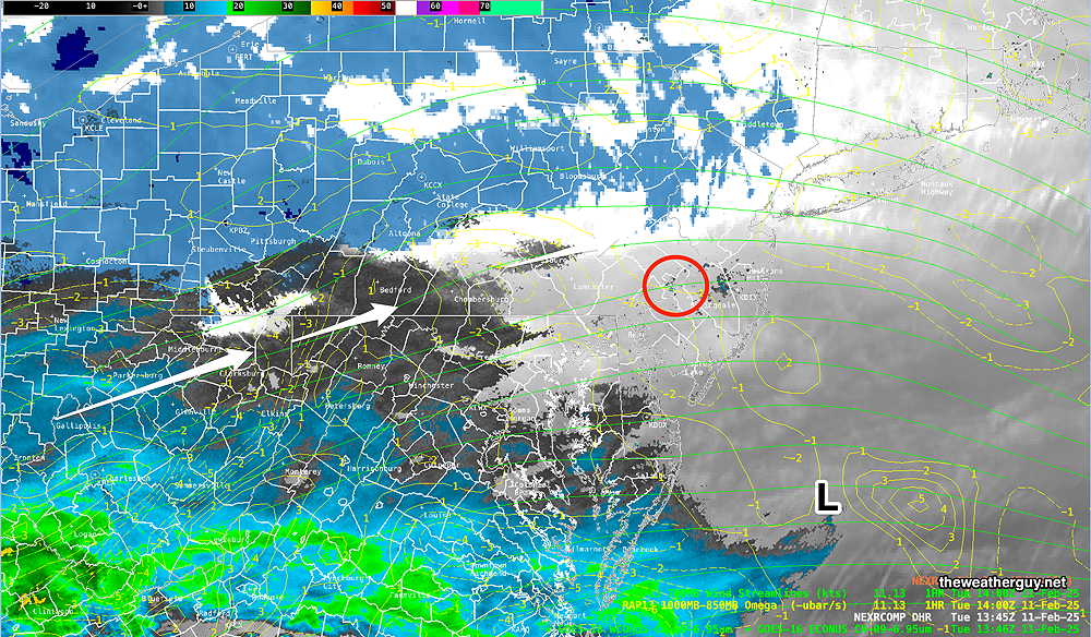
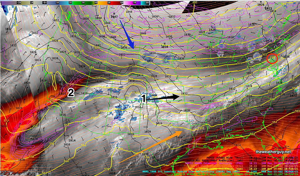
Fast moving low pressure in western Canada will move eastward and will move north of our area on Saturday. This disturbance is just becoming visible on satellite water vapor imagery—

Current satellite water vapor image with superimposed RAP model 500-1000 mb thickness lines (yellow), Mean Sea Level Pressure isobars (black contours) potential vorticity (fine violet contours) with superimposed MRMS RADAR. Low pressure in western Canada will be north of us on Saturday. (Click on image for a larger view.)

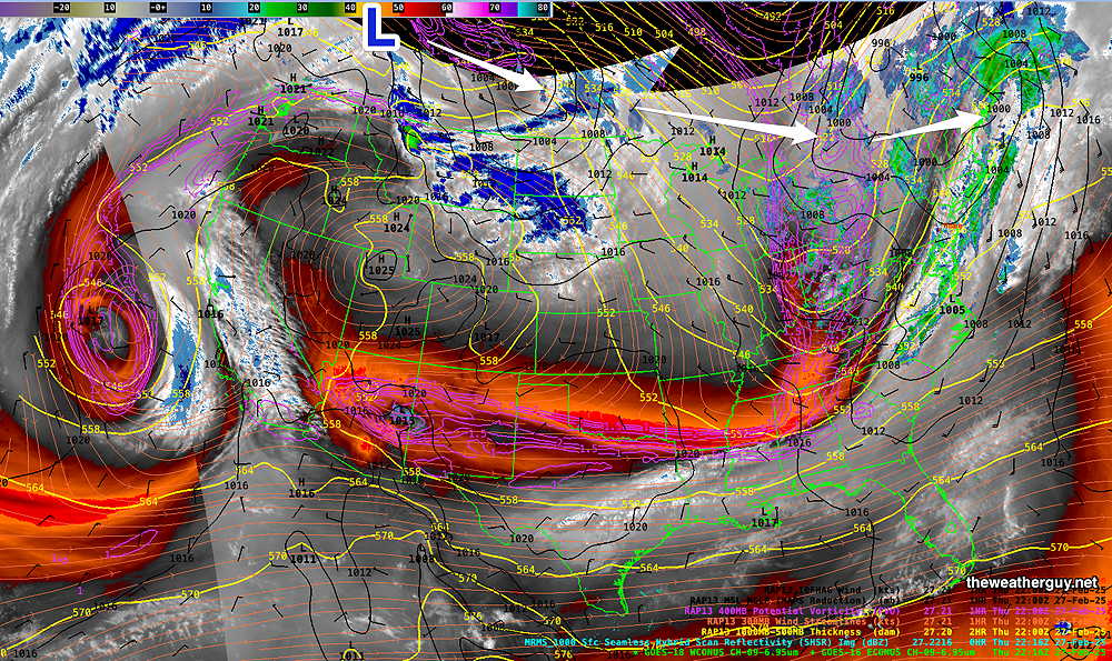
By 2 PM Friday, the GFS shows our area to be somewhat windy with partly sunny skies. Highs will have trouble just getting past 50º on Friday. The approaching low will be over the Great Lakes area—

18z GFS shows low pressure over the Great Lakes. (Click on image for a larger view.)

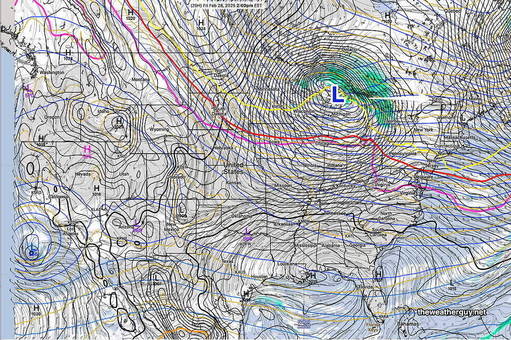
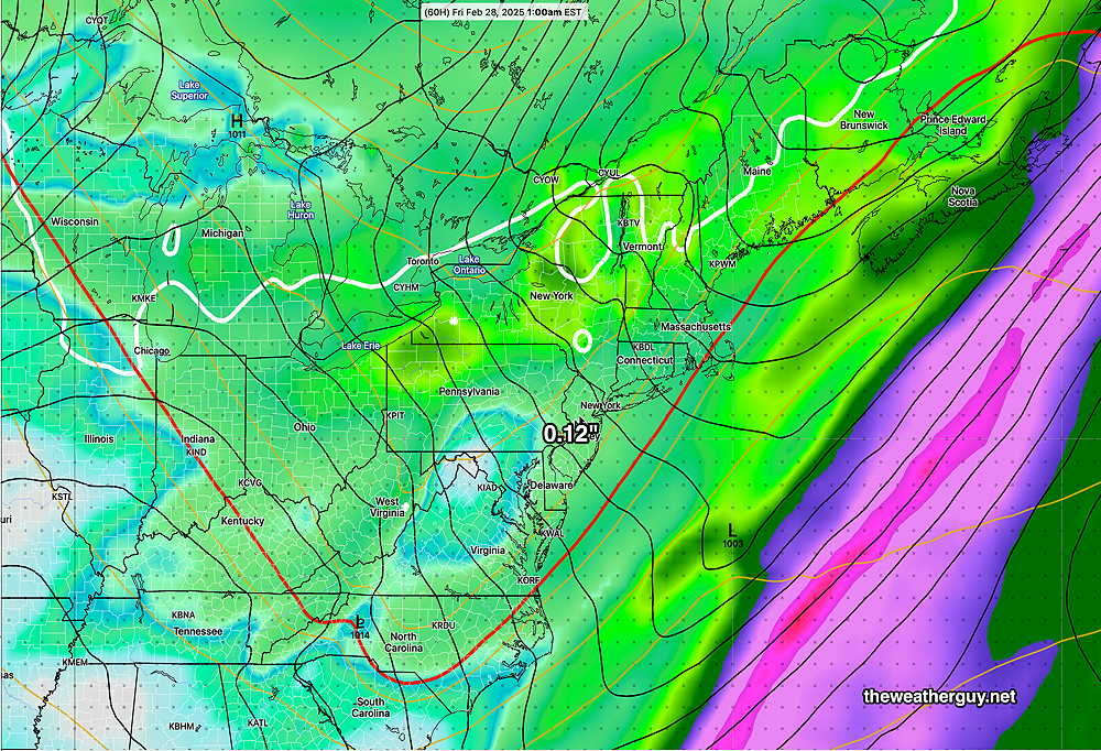
A sharp cold front moves through Saturday and very cold temperatures move in for Sunday and Monday.


Posted Wednesday 02/26/25 @ 9:02 PM — After a mostly sunny day on Wednesday, we’ll see clouds move in for Thursday. Very light scattered showers will be with us by morning and continue into the afternoon.

As has been the case lately, we’ll see only 0.10″ of rain or less. The Philadelphia area has been in a “doughnut hole” of rain with most systems for the past 9 months or so. As mentioned in my forecast review, I don’t currently see a change in that pattern in the extended forecast range of 2 weeks.

For tomorrow, the new AI model from the ECMWF captures the pattern of the heavy rain bypassing our area—

18z ECMWF-AIFS SINGLE model rain accumulation forecast through Friday morning. (Click on image for a larger view.)

Tue 9:31 PM —Forecast Review — We had much more sunshine than forecast today. The lack of showers was not a surprise, as the forecast for scattered amounts in the 0.01 to 0.02 range can often be model “noise”.

That said, I see a continuing lack of significant rainfall in our area. We went into the winter with a rainfall deficit and we have had only a few decent rainfalls over recent months. I don’t see much in the way of heavy rainfall in the extended model forecasts. A case in point— a week ago, the models suggested a decent rainfall for this Thursday. Current model forecasts are showing a minimal amount of rain on Thursday.

That trend towards lower rainfall amounts in the model forecasts has continued. The basic pattern has been for rain to move off to our northwest or out in the Atlantic. If this pattern continues, we’ll have some significant rainfall deficits by late Spring.

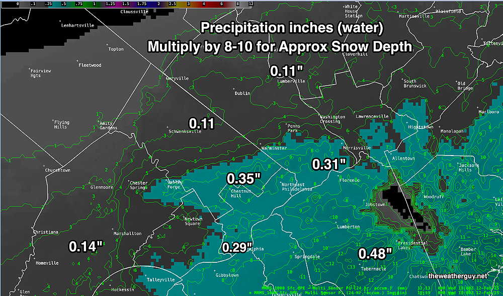
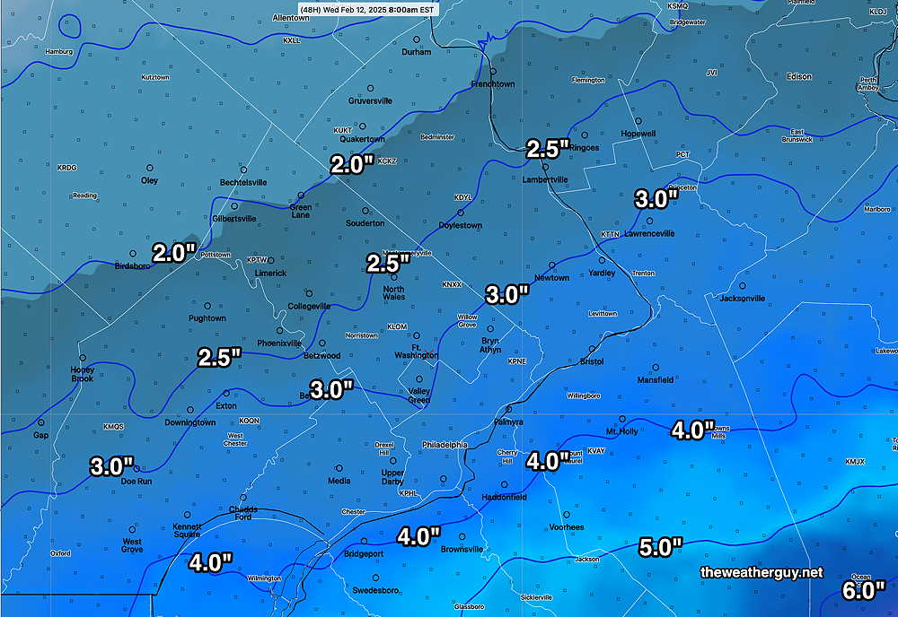
Here’s the latest total accumulated rainfall forecast for Thursday, based on the new AI model, the “ECMWF-AIFS-Single”—

18z ECMWF-AIFS Single total rainfall by 1 AM Friday morning. (Click on image for a larger view.)

Tuesday Forecast

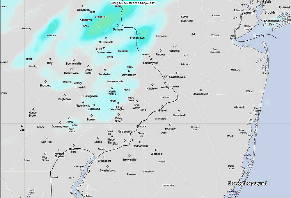
Posted Monday 02/24/25 @ 6:17 PM — The weak front that moves through on Tuesday is expected to bring plenty of clouds and mild temperatures despite the lack of sunshine. Some sprinkles are possible anywhere from 3 PM to 7 PM, but any precip will be extremely light, on the order of 0.01 to 0.02 inches of water.

It should be noted that the ECMWF and the new ECMWF “Single AI” model show no precip at all in Philadelphia and very light precip to the far northwest, near Allentown and Reading. Depending upon the models, the clouds may dissipate late afternoon or hang tight a bit longer.

18z NAM-NEST shows very light total precip west of Philadelphia by 7 PM. 0.01 to 0.02 inches of water. (Click on image for a larger view.)

Previously Posted Sun @ 4:38 PM — —A trend towards milder weather this week has been well-advertised. As we saw about two weeks ago, the AI models are forecasting highs to be somewhat higher than the operational models.

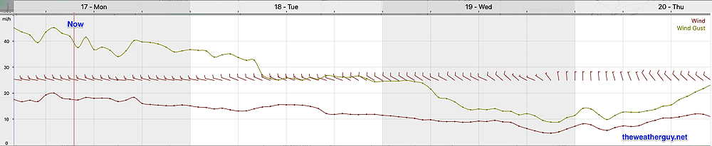
First, here’s what’s happening now, Sunday afternoon—

Current satellite water vapor image with superimposed RAP model Mean Sea Level Pressure isobars (black contours) potential vorticity (fine violet/yellow contours) with superimposed MRMS RADAR. (Click on image for a larger view.)

Monday will be windy and gusty in the afternoon, ahead of a weak front.

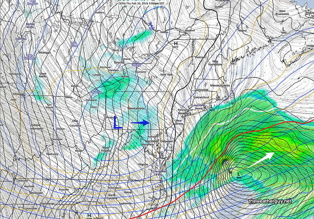
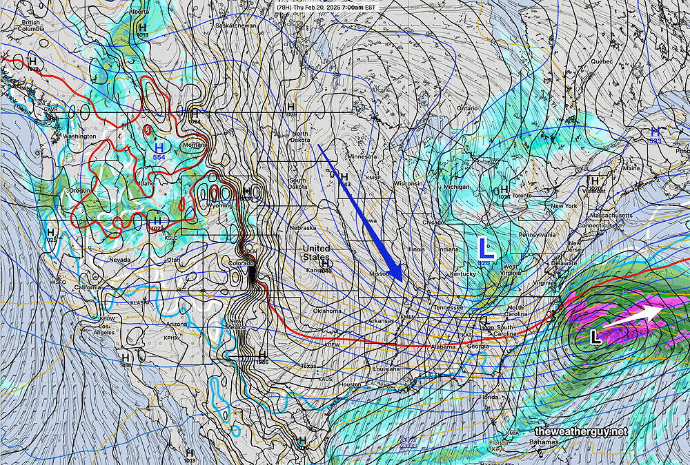
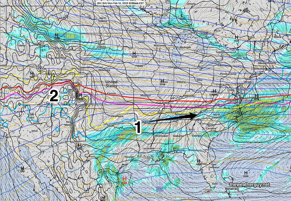
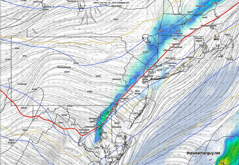
The low pressure system in Canada (L) will move rapidly eastward and a front will develop to our west associated with that northern system on Tuesday with clouds and some showers possible mid afternoon according to the GFS and NAM-NEST.

02-23-25 12z GFS forecast for Tuesday at 3 PM. (Click on image for a larger view.)

It will briefly colder Tuesday night, but temperatures partly rebound on Wednesday.

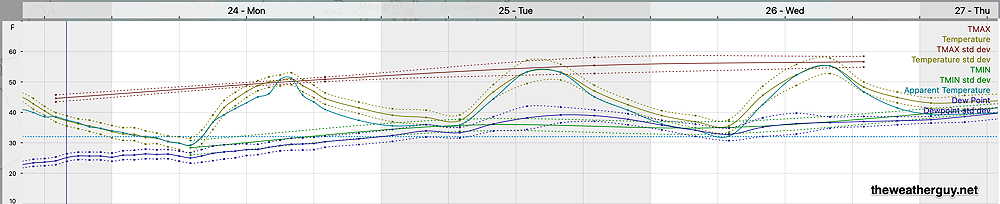
Here’s the NBM temperature meteogram, for Blue Bell, showing its high temperatures (TMAX)—

12z NBM high temperatures, temperatures and dewpoints for Blue Bell PA (Click on image for a larger view.)

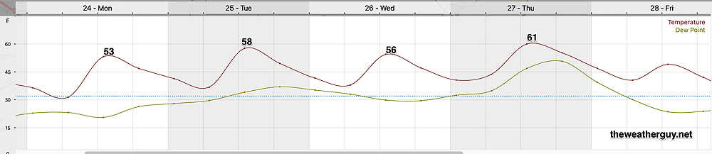
The new ECMWF-Single AI model shows these highs—

12z ECMWF Single (AI) forecast temperatures at 1 PM. The free version does not offer a TMAX, and it’s every 6 hours, so you don’t see the high temperature at 3 PM; You can probably add at least two degrees to its temperatures shown. (Click on image for a larger view.)

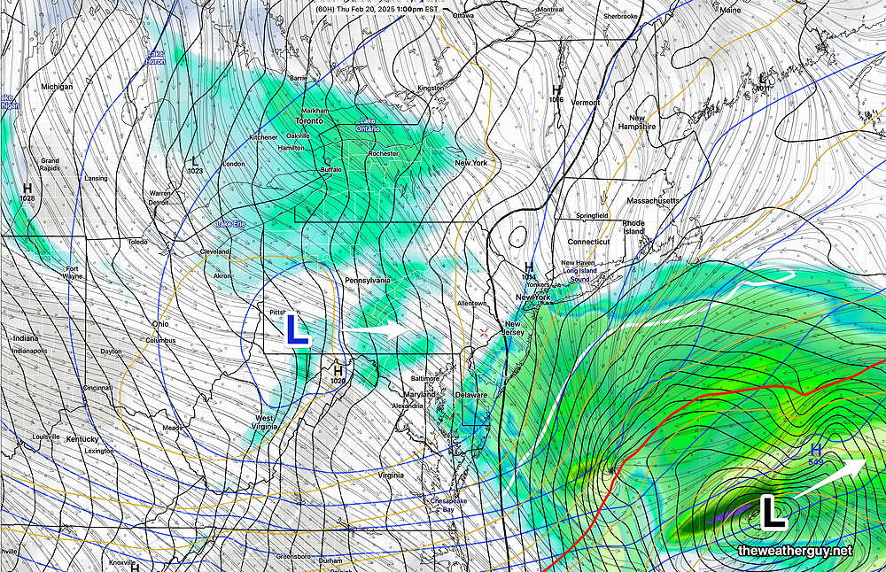
By Thursday afternoon, another stronger cold front is expected to move through with some rain—

A cool down for Friday and another cold weekend follows, but then a big warmup for the first week in March.


THIS WEEK’S WEATHER

Forecast Update- Thursday

Posted Thursday 02/20/25 @ 11:03 AM — The models continue with spotty light flurries or snow showers for today, beginning about 3-4 PM and ending by 8 -10 PM. Total snowfall is expected to be very light with little more than a dusting or coating in most areas. Here’s the latest HRRR

12z HRRR total snowfall for Thursday by late evening. (Click on image for a larger view.)
Thursday Forecast Update

Posted Wednesday 02/19/25 @ 9:20 PM — As posted late afternoon, any light snow/snow showers/flurries on Thursday will occur in the afternoon into the evening due to an an upper level low. The afternoon models and this evening’s latest HRRR/NBM are showing varying amounts of light accumulation, from a dusting and coating to 1/2″ accumulation.

Here’s tonight’s HRRR—

Tonight’s 00z HRRR snow accumulation forecast by 11 PM Thursday.

Here’s the latest 01z NBM, showing even less—

Right now, I don’t see any additional snow likely in the short range or even next week, which may have two periods of rain.


Thursday Forecast Update

Posted Wednesday 02/19/25 @ 5:12 PM — The storm, forecast days ago for Thursday, completely misses our area. No real surprise, since that trend had been captured by the majority of the models for days.

The NBM, perhaps influenced by the NAM forecast, kept snow in the forecast for Southern NJ longer than it should have. (Regardless of when the NAM is retired, the next version of the NBM scheduled for release in April 2025 will be excluding NAM model precip data.)

Thursday will still be cloudy due to an upper air low that passes over our area. A few flurries are possible. Still cold with a high temperature in Philadelphia about 30º-31º and about 2º colder in Blue Bell.


Yet Another Forecast Change

Posted Wednesday 02/19/25 @ 9:38 AM — Last night’s 01z, 07z and the latest 13z NBM model forecasts show a constant evolution towards the southern storm entirely missing us .

Any snow in the immediate Philadelphia area (and parts of South Jersey) being the result of an upper air low. The light snow/flurries/snow showers will occur late in the afternoon Thursday. Here’s the latest NBM—

Today’s 13z NBM forecast snow accumulation by 11 PM Thursday evening. (while I’ve labeled the 0.5″ inch line, there will be no accumulation over the ocean.) :-)(Click on image for a larger view.)

The NAM forecast shows the upper low—

This morning;s NAM forecast for 1 PM Friday showing the upper level low to move east over us. The NAM cranks out 0.5 inches of snow, but it remains an outlier. (Click on image for a larger view.)

Thursday Forecast Update

Posted Tuesday 02/18/25 @ 6:06 PM — The afternoon NAM has backed off from its morning forecast. The model blend (NBM) captures the general trend, with just a coating in the immediate PHL area and 1-3 inches in NJ.

02-18-25 19z NBM snow accumulation by Thursday evening. (Click on image for a larger view.)

I’m keeping an eye on the models and look for an update either this evening or Wednesday morning.


A Change in the Forecast?

Posted Tuesday 02/18/25 @ 9:15 AM — Last night’s models continue forecasting Thursday’s main surface low tracking off to our south and east missing us. The models have been on-again off-again with showing some light snow showers from the upper low that will pass over PA on Thursday.

Of some interest is the latest NAM forecast. (FYI, development of the NAM was discontinued in 2017 and is scheduled for “retirement” in 2025. The NAM has a history of over-forecasting snow in the 48-60 hour time range.)

That said, it is the only model showing the precipitation shield covering South Jersey on Thursday, with some significant accumulation. It’s currently an outlier with this storm. Here’s the current NAM forecast for Thursday—

02-18-25 06z NAM forecast for Thursday. An outlier with this storm, it’s forecasting some significant snow for South Jersey and a coating or so for us. The upper level low shown near Pittsburgh may bring some snow showers here; just a coating in Philadelphia. (Click on image for a larger view.)

With most models at most showing snow showers for Philadelphia on Thursday, I’ve posted the NAM as food for thought. I’ll update later if the other models join in on its forecast.


A note for those of you who are visiting this site from “X“.
Due to the highly unbalanced political environment on X, I’ve considerably cut back auto-posting there. To receive all forecast postings, I recommend following me on mastodon.social or bluesky.social

Dry and Cold

Posted Monday 02/17/25 @ 5:08 PM — Cold high pressure continues to build in. Tuesday and Wednesday will be quite cold and it appears that there may be some cloudiness mid day on Tuesday due to an upper air disturbance.

02-17-25 18z NBM forecast high temperatures for Tuesday. Standard deviation is ± 1.4º (Click on image for a larger view.)

Winds will be subsiding compared to Monday, but wind chills during period of maximum temperatures (3-4 PM) will be in the 11º -17º range.

Those looking for a snow day will be disappointed on Thursday. ALL models are forecasting the over-advertised storm on Thursday to track too far to our south and east. We may see some flurries and the NJ shore may see some light snow.


Originally Posted Mon 9:47 AM —The intense pressure gradient between the low pressure system that departed Sunday and building high pressure continues to create wind gusts in excess of 35 mph. (Gee, I hope no one on TV uses the expression “wind tunnel effect” to incorrectly explain the cause of these winds.)

GFS forecast wind and wind gust meteogram for grid point Blue Bell, PA (Click on image for a larger view.)

For today, a brief period of cloudiness may develop early afternoon due to instability and an upper air disturbance. Otherwise sunny.

Cold high pressure will be with us through at least Thursday. Low pressure that was advertised as bringing us snow Thursday increasingly appears to move too far off to our south.

ECMWF forecast for Thursday- coastal low pressure moves off to our southeast. An upper low (blue L) may bring some light snow showers to us. (Click on image for a larger view.)

It wasn’t too long ago that forecasters would keep an uncertain view of this forecast. A big change has been the development of AI models. With both the GFS GraphCast AI and the ECMWF AIFS models showing this storm moving far southeast of our area, it seems increasingly unlikely that a shift closer to the coast will occur.

Coastal South Jersey may be brushed with some snow on Thursday from this system. And the Philadelphia area may see some snow showers from an upper low pressure system moving over PA. But a significant snowstorm seems very unlikely at this point.


THIS WEEK’S WEATHER

Clearing Today – Cold Friday- Snow Saturday

Posted Thursday 02/13/25 @ 8:47 PM — Accumulating snow on Saturday afternoon looks less likely. Possibly a coating in northwest suburbs before a changeover to rain.


Posted Thursday 02/13/25 @ 9:28 AM — Several large shifts in temperature and weather over the next several days.


Today (Thursday) — Clearing around 2-3 PM and becoming windy and gusty. Mild but temperatures chill down later today and tonight.

Friday (Super Bowl Parade) — Sunny breezy and cold.

Saturday— Snow develops in the morning from west to east. Precip changes to sleet, then rain early evening hours. Preliminary snow accumulation (GFS model) about 1-3 inches mostly from the city north and west.

Today’s 06z GFS forecast for 5 PM Saturday showing precipitation type (PTYPE) (violet= snow) surface temperature (white contour) and low level vertical temperatures (magenta, purple contours) Shading is PTYPE; it does NOT indicate the exact coverage or intensity of the precipitation at that time. (Click on image for a larger view.)

Wednesday Night through Friday

Posted Wednesday 02/12/25 @ 5:13 PM — Our next in a series of disturbances is approaching and should be here by 6 PM -8 PM—

MRMS radar around 5 PM with superimposed RAP model 700 mb winds and Omega (Click on image for a larger view.)

Temperatures in most of the region will be above freezing, but some of the earliest precip may begin as light snow, quickly changing to rain.

NBM temperature and precipitation type at 8 PM Wednesday evening. White contour is 32º line (Click on image for a larger view.)

Total rainfall is expected to be about 0.45 to 0.65″ tonight with higher amounts in South Jersey and near the coast.

Thursday: Cloudy in the morning, then sunshine breaks out in the afternoon. Windy and gusty with highs in the low 50s!

Friday: The Super Bowl Parade will have sunshine and breezy conditions. High temperatures will be near 37º in the city.


Rain Wednesday night

Posted Wednesday 02/12/25 @ 9:44 AM — The models maintain cloudiness for us today, Wednesday. Many models crank out some very light snow or flurries beginning in the afternoon. (Temperatures in the upper atmosphere remain cold enough for snow from the city northwestward despite temperatures moving above freezing for much of the area.)

NBM precipitation Type at noon Shading doesn’t mean it’s snowing or raining, just the conditional probability of snow or rain in an area at this specific time.. (Click on image for a larger view.)

As another area of low pressure slides towards us, temperatures at all levels will rise above freezing. Total additional rainfall about 0.30″-0.40″ water by Thursday 8 AM.


Wed 9:23 AM —Forecast Review —The immediate Philadelphia area received slightly more precipitation in the form of snow than forecast below by the NBM . Areas to the west and north received slightly less than forecast. Areas in NJ received somewhat more than forecast. Overall, the forecast was fairly good.

Here’s the MRMS precipitation estimate for the past 24 hours given in inches of water. Based on actual measurement, multiply by 8-10 to get approximate snow depth.

MRMS rain-gauge measured rainfall combined with rain-gauge calibrated and interpolated radar-based summary of ACTUAL PRECIPITATION RECEIVED. Color shading is in inches. Line contour numbers are in mm. (25.4 mm= 1 inch)       (Click on image for a larger view.)

Measured snow totals from the NWS

...Bucks County...
Levittown 3.5 in 0548 AM 02/12 Trained Spotter
2 ESE Newtown 2.5 in 0634 AM 02/12 Other Federal
1 NNW Langhorne 1.8 in 1130 PM 02/11 Trained Spotter
Upper Southampton Twp 1.6 in 1250 AM 02/12 Trained Spotter
Plumstead Twp 1.6 in 0430 AM 02/12 Trained Spotter
Bensalem 1.5 in 1024 PM 02/11 Public
Fricks 1.5 in 0709 AM 02/12 Trained Spotter
Furlong 1.0 in 1230 AM 02/12 Trained Spotter

...Chester County...
East Nantmeal Twp 3.3 in 0700 AM 02/12 Trained Spotter
Berwyn 3.2 in 1038 PM 02/11 Trained Spotter
West Chester 3.1 in 0600 AM 02/12 Public
Jennersville 2.7 in 0556 AM 02/12 Public
1 WNW Chesterbrook 2.7 in 0634 AM 02/12 Trained Spotter
West Caln Twp 2.5 in 0553 AM 02/12 Trained Spotter
East Coventry Twp 2.0 in 0530 AM 02/12 Public

...Delaware County...
Boothwyn 3.7 in 0120 AM 02/12 Trained Spotter
Chadds Ford Twp 1.8 in 1000 PM 02/11 Trained Spotter

...Montgomery County...
Norristown 3.1 in 0613 AM 02/12 Trained Spotter
Plymouth Meeting 3.0 in 0100 AM 02/12 Public
King of Prussia 2.7 in 0604 AM 02/12 Trained Spotter
1 E Willow Grove 2.5 in 0600 AM 02/12 Trained Spotter
Eagleville 2.3 in 1200 AM 02/12 Public
1 NNE Willow Grove 2.0 in 1228 AM 02/12 Public
Eagleville 2.0 in 0630 AM 02/12 Trained Spotter
New Hanover Twp 1.9 in 0500 AM 02/12 Trained Spotter
East Norriton 1.8 in 1100 PM 02/11 Public
1 ENE Plymouth Twp 1.6 in 1222 AM 02/12 Public


...Philadelphia County...
Philadelphia Intl Airport 3.1 in 0700 AM 02/12 ASOS
1 SSE Center City 3.1 in 0713 AM 02/12 Public
Bustleton 3.0 in 0523 AM 02/12 Trained Spotter
Fox Chase 2.9 in 0530 AM 02/12 Trained Spotter

Tuesday Snow Update

Posted Tuesday 02/11/25 @ 7:54 PM — Looking at the latest hourly models (RAP and HRRR), it appears that we may get even less snow than the recent NBM forecast posted. I see very little in the way of pressure falls off the coast and negative omega values are plentiful, meaning less dynamics to result in snow intensification.

The ‘heaviest’ snow (air quotes placed for a reason) is still forecast to occur between 9 PM and midnight, then taper and end around 3 AM.

Here’s the latest HRRR which shows additional snowfall from 6 PM onward—

HRRR 23z Additional snowfall from 23z (6PM) onward. Even this may be too high. (Click on image for a larger view.)

Posted Tuesday 02/11/25 @ 4:32 PM — Additional models have become available since my last update. Little has changed with total precipitation around the city ranging from 0.18″ to 0.28″ water equivalent. This translates into a similar snow forecast as described earlier.

Currently light precipitation has just begun to fall in our area. As expected, the main area of precipitation is south of our area. Evaluation of vertical upward motion (“Omega”) shows low pressure will develop far off the Delmarva coast in the area designated (L) . In our area, there are little signs of intensification, but area of strong vertical motion in West Virginia now will bring some heavier snow here about 11 PM or so.

Evaluation of vertical upward motion (“Omega”) shows low pressure will develop far off the Delmarva coast in the area designated (L) . In our area, there are little signs of intensification, but area of strong vertical motion in West Virginia (1) now will bring some heavier snow here about 11 PM or so. (Click on image for a larger view.)

Despite somewhat heavier snow forecast from the ECMWF, I’m sticking with the latest model blend (NBM)—

19z NBM Snow accumulation forecast by 7 AM Wednesday. (Click on image for a larger view.)

Show More