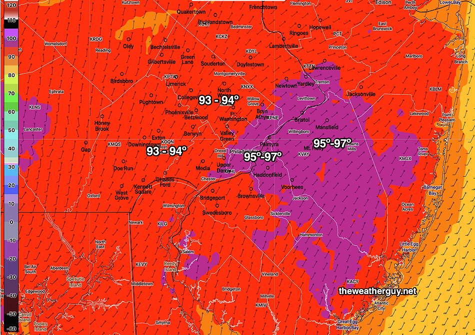
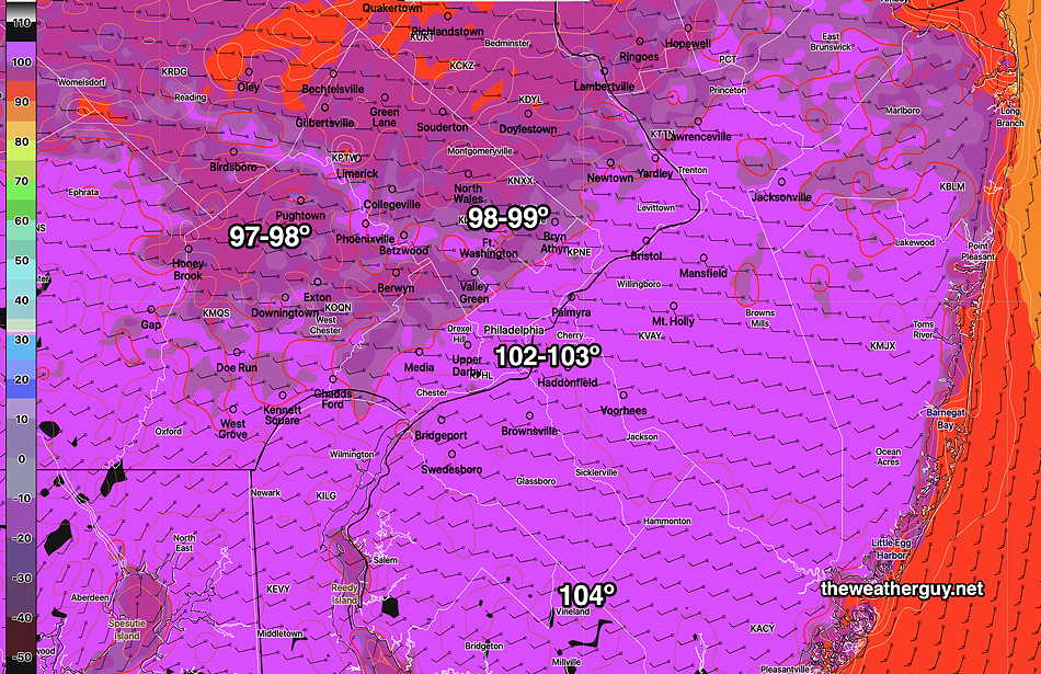
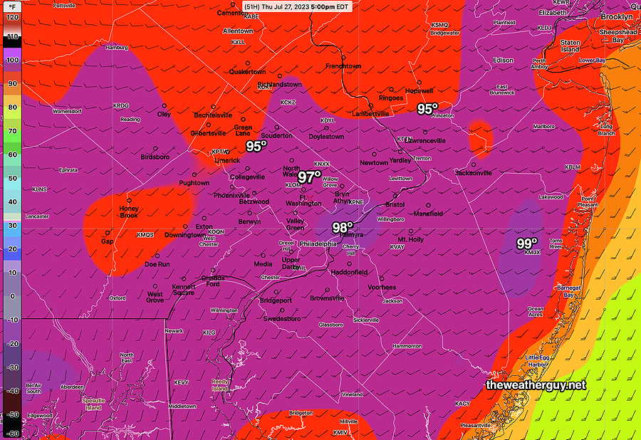
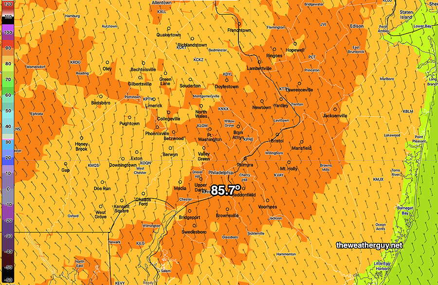
Updated Fri 07/28 @ 9:41 AM — The high temperatures and apparent temperatures (heat index) for today have been well-advertised. Here’s the latest NBM forecast—
Here’s the NBM Heat Index high (apparent temperature) occurring between 2:45 and 4 PM.—
(Click on image for a larger view.)
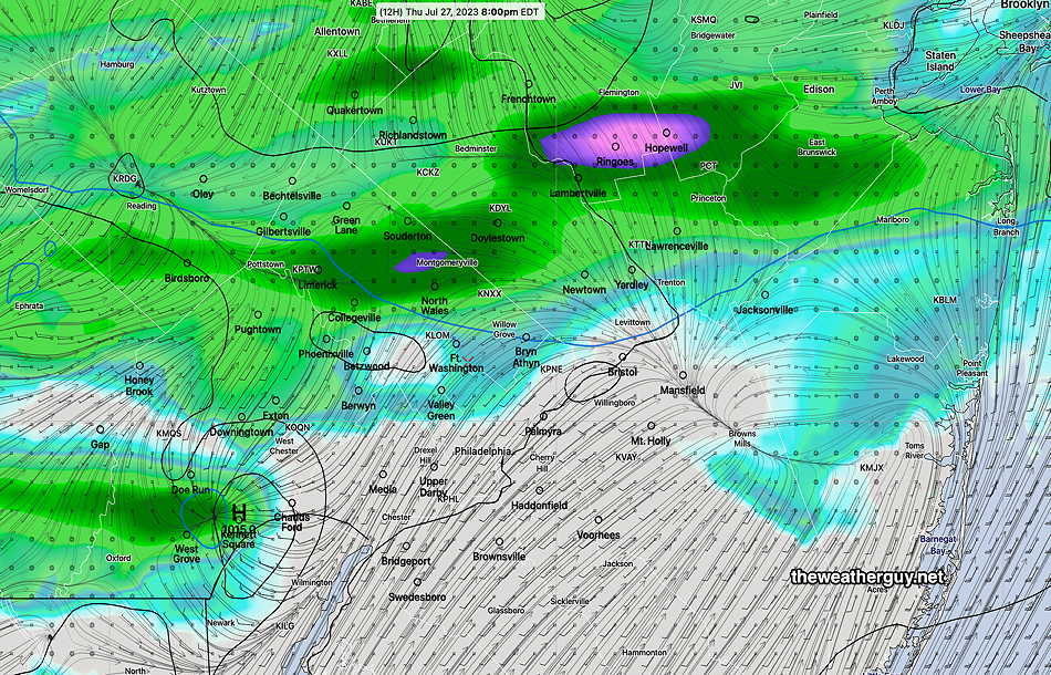
A few widely scattered showers about 7 PM; most areas dry.
Another Forecast Change?
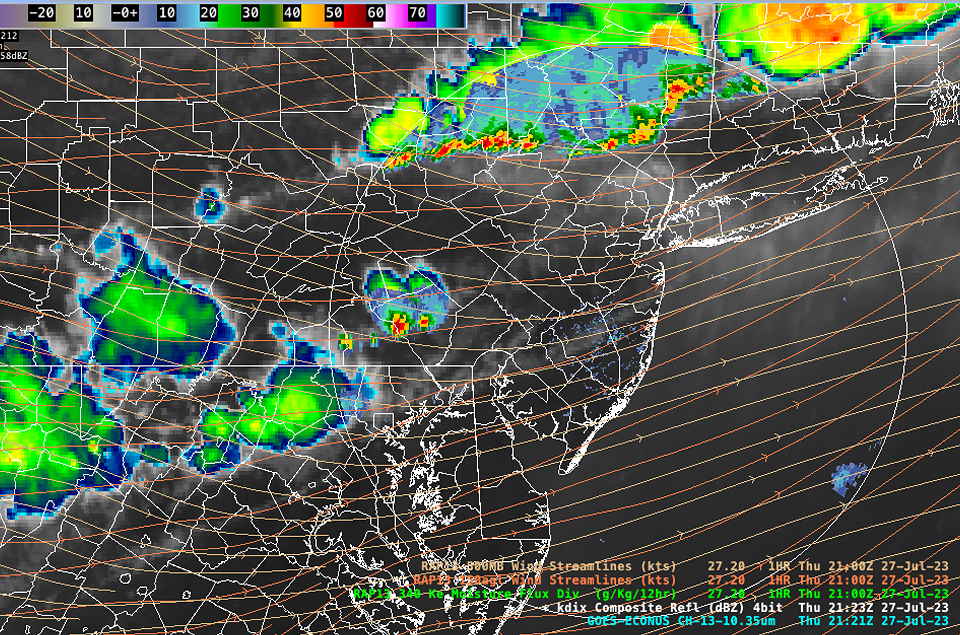
Update Thu 07/27 @ 5:36 PM— So far there hasn’t been any storm activity in the immediate PHL area and that may not change. The cloud cover we had earlier put a lid on things developing so far.
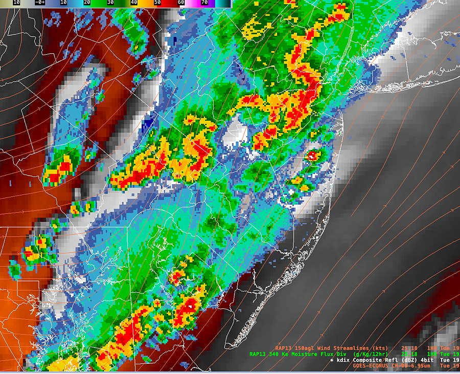
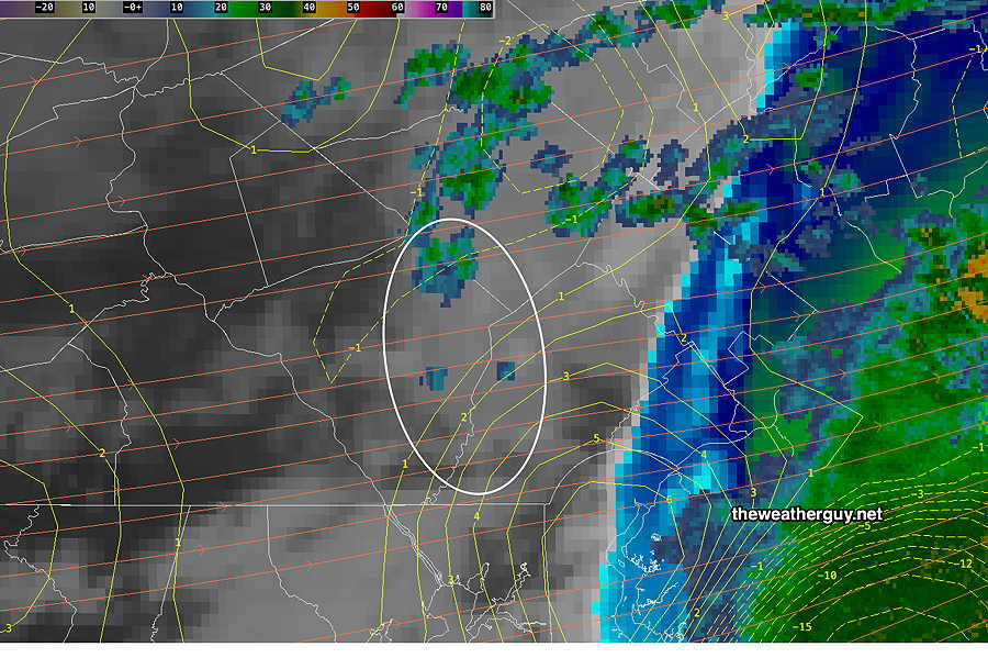
The latest satellite and radar shows some activity developing to our west—
Satellite chan 13 and Radar at 5:21 PM. Disturbances to our west may reach here within the next 2-5 hours. (Click on image for larger view.)
The latest HRRR keeps this activity moving through the western suburbs and falling apart as it hits the city. The latest HRDPS has the storms moving through Philadelphia into NJ over the next 2-5 hours. Which is correct? Who knows, but the HRDPS has earned my respect in recent weeks.
Forecast Change
Updated Thu 07/27 @ 11:39 AM — A review of this morning’s models suggests a somewhat different picture and a different forecast. Significant cloud cover has reduced the previously rapid increase in temperatures.
Several models now keep the storms to the north and west of most of the immediate PHL area. Many areas won’t see any thunderstorm activity, according to the latest models.
The latest HRDPS captures this—
Today’s 12z HRDPS shows many areas from the city, south and east, will see no thunderstorm activity this afternoon or evening. (Click on image for a larger view.)
The 12z NAM-NEST shows a very different coverage of storms today—
Today’s 12z NAM-NEST also shows large areas unaffected by today’s thunderstorms.
So the previous forecast certainty of severe thunderstorms has become less than certain for many areas. Is the potential change the result of model spin up issues? Is it cloud cover reducing overall CAPE and temperatures and increasing CIN? I guess we’ll see.
Thursday- Potential for Scattered Severe Storms Likely
Updated Thu 07/27 @ 7:49 AM — The expected high heat and humidity for today has been well-advertised. As mentioned last night, the potential for scattered severe storms (which may form a line) appears to be in the likely category.
Based on a review of last night’s models (00z and 06z runs) a strong mid and upper level wave will move through our extended area between 2 PM and 6 PM with some activity still possible as late as 8 PM.
(There are timing differences in the models. The HRRR has a 4-6PM peak time frame, while the HRDPS has an earlier start time in the northwestern suburbs: 2 PM)
Heavy rain, strong wind gusts, potential hail and a slight-minimal risk of tornadic activity are all possible today.
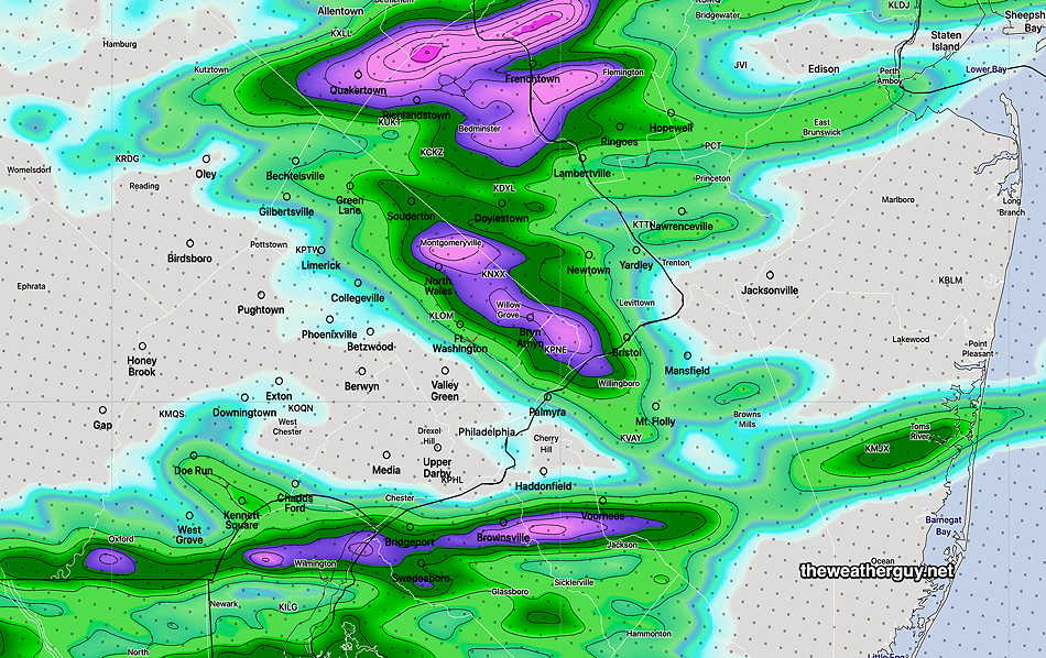
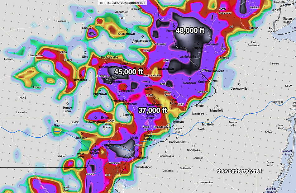
One way the models estimate the severity is by estimating the height of cumulonimbus clouds (thunderheads). Referred to as “echo tops” in the models, (as measured by radar) typical very strong/severe thunderstorms show echo tops of 38-40,000 feet above ground. Several of last night’s models show echo tops of 45-48,000 feet!
06z HREF Echo Tops forecast for 5 PM Thursday. (Click on image for a larger view.)
Below is today’s Severity Table, based on the 06z HRRR. As mentioned last night, some (but not all) of the parameters are the most extreme I’ve seen this season. (Notably missing is jet stream wind energy.)
HRRR Severity Parameter
Sept 1 , 2021 Tornado Outbreak (example of highly severe)
Recent April 1st 2023 Tornadoes (Example of severe)
Severity Parameters Impact: ⚑ indicates favors Severity ⚐ indicates Possible Severity ↔. indicates marginal effect ↓ indicates works against Severity ⇩ Significant, but less impact
As you can see, many parameters put us in the high probability of scattered severe storms. Most notably missing is jet stream wind energy; we’ll see how this impacts the forecast.
Hot Thursday – Potential for Severe Storms
Updated Wed 07/26 @ 9:50 PM —The hot air that’s been in the news affecting the Southwest and Central US this summer will be poking into our area Thursday and Friday.
Additionally, a strong disturbance in the mid and upper levels of the atmosphere will pass through our area between 2PM and 6 PM Thursday. The models are showing extremely high CAPE and precipitable water. Some of these severity parameters are the highest we’ve seen this season.
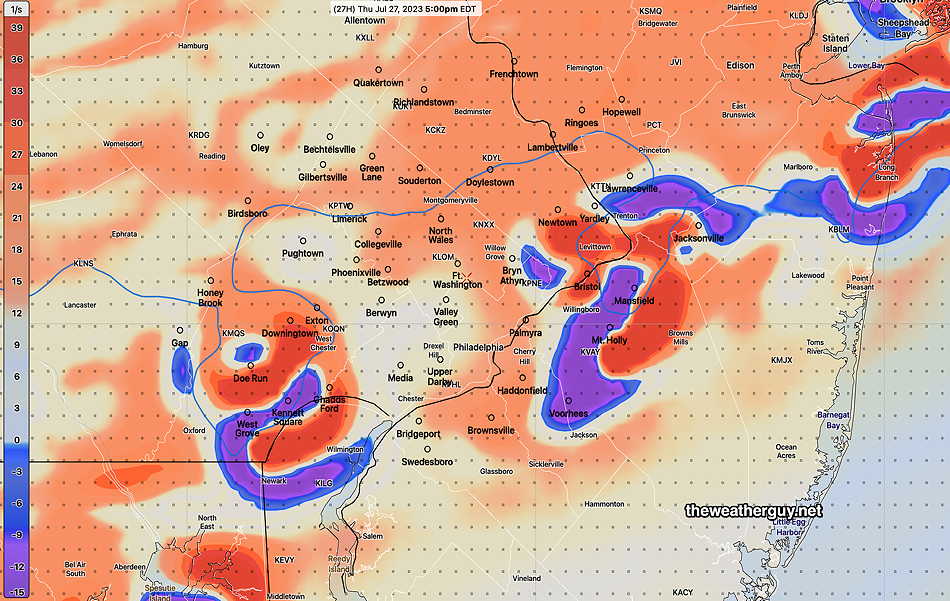
These disturbances are parameterized by the models as areas of strong positive and negative vorticity. It’s not often to see such strong vorticity couplets intertwined, as shown in the HRDPS below—
18z HRDPS 500 mb vorticity and geopotential height (~18,000 feet) at 5 PM. Very strong positive and negative areas of vorticity showing as intertwined couplets (the “conservation of momentum” in action.) . Notice how this strong upper wave distorts the usual straight line blue line of equal 500 mb height (“isohypse”) (Click on image for a larger view.)
Combined with this disturbance, scattered or clustered strong and severe storms will affect our area with localized heavy rain possible during the 2 PM to 6 PM time frame.
Looks to be very interesting. Updates tomorrow morning with the new HRRR.
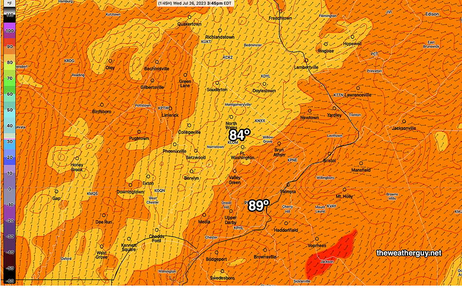
Wed 5:42 PM Forecast Review — We weren’t as hot today as had been hyped on the TV forecasts, and even this morning’s NBM model (shown here) overshot the actual temperatures. Dew points were only in the high 50s and low 60s at the peak temperatures.
Here’s the RTMA temperatures at recorded at 3:45 PM —
RTMA model temperatures (actual or estimated preliminary) at 3:45 PM. (Click on image for a larger view.)
I do think we’ll get closer to the high heat values Thursday and Friday.
Wednesday Update
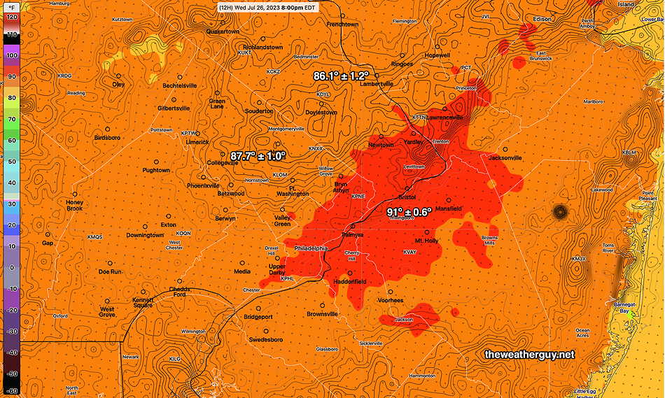
Updated Wed 07/26 @ 10:05 AM — The latest NBM high temperature for today with statistical spread (uncertainty)—
Today’s 12z NBM Max mean temperature forecast with statistical spread (uncertainty) contours. Areas of greatest contour density have the greatest statistical range of uncertainty. I’ve found the NBM tends to run somewhat low in summer here. With the NBM and summer high temperatures, generally add the uncertainty to get the likely temperature. (Click on image for a larger view.)
Wednesday Outlook
Updated Tue 07/25 @ 8:45 PM — For Wednesday, temperatures near 89-90º but dew points in the low 60s will keep heat indices close to the actual temperatures.
For Thursday, actual temperatures go well into the 90s with dew points into the upper 60s to near 70º. A disturbance may cause showers/thunderstorms Thursday afternoon or evening.
Thursday high temps—
Today’s 18z GFS max temperature forecast for Thursday. These are actual temperature. Heat indices over 100 in many areas.
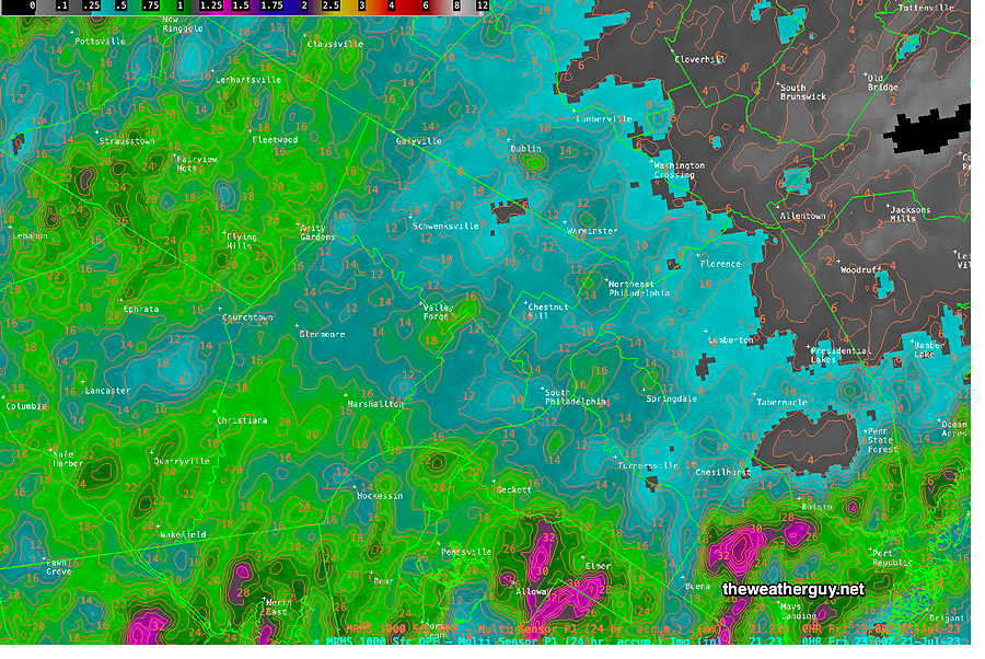
Tue 4:02 PM Forecast Review —Little in the way of severe storms, but much more areal coverage and heavy rain than one would have guessed from the several forecasts I heard on the radio which seemed to be only forecasting ” scattered storms” this morning.
Radar with superimposed RAP model winds at 3:45 PM Tuesday. (Click on image for a larger view.)
Today’s thunderstorms were yet another example where the HRDPS model seems to have done much better than our seemingly more sophisticated HRRR model this summer season. Not sure why.
Tuesday Forecast Update
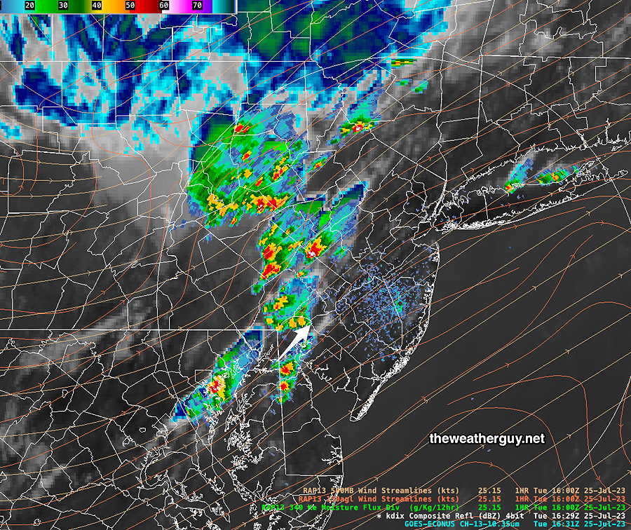
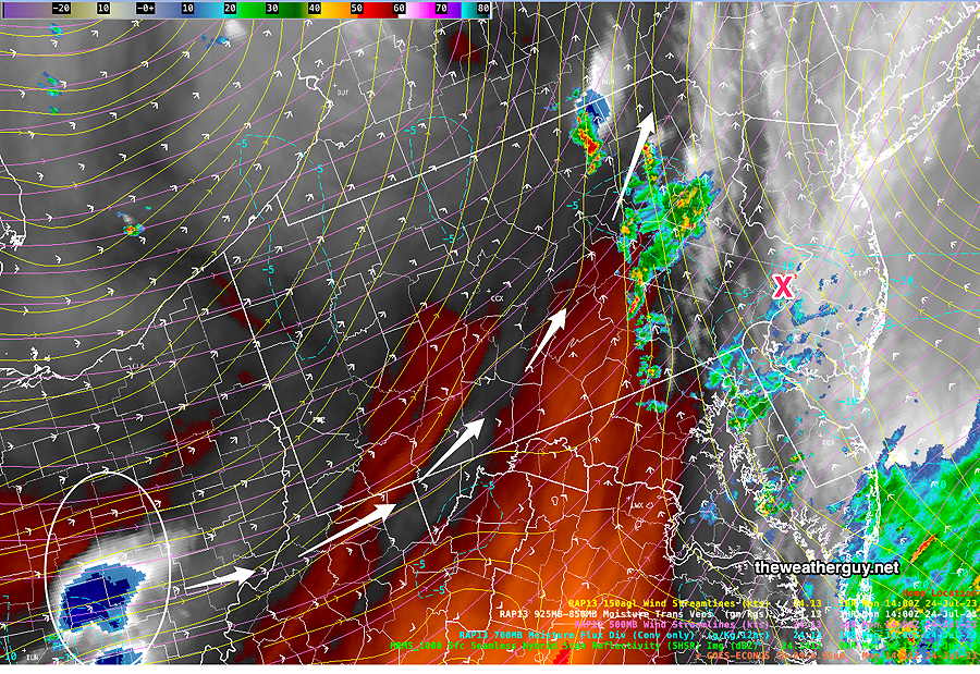
Updated Tue 07/25 @ 12:36 PM — The storms have broken out even earlier than 2 PM originally forecast—
Radar at 12:31PM with superimposed RAP model boundary level winds and IR satellite image. (Click on image for a larger view.)
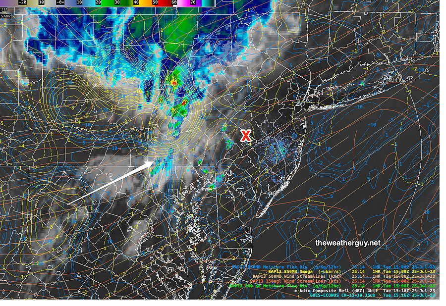
Updated Tue 07/25 @ 11:26 AM — This morning’s HRRR forecast has much more scattered storms than the NAM-NEST or HIRESW or previous Canadian RGEM/HRDPS. I’m leaning towards greater coverage of storms today. Severe parameter levels are only in the moderate range, but it doesn’t preclude severe activity.
Satellite IR with RAP model overlays. The impulse that will set off our storms is shown in Maryland (yellow contours and white arrow) at 11:15AM. Some showers already breaking out in the Valley Forge area. (Click on image for a larger view.) (Click on image for a larger view.)
Tuesday Forecast Update
(readers- a half-baked forecast update posted about 15 minutes ago was accidentally published. It’s been deleted.)
Updated Tue 07/25 @ 8:48 AM — A review of the 2AM (06z) HRRR and Canadian RGEM suggests a more toned-down severe forecast. The storms will move in earlier, possibly as early as 2-3PM in the western suburbs and move east. They will be more scattered.
The HRRR model is showing significant areas of CIN (Convective Inhibition) that will persist, making any activity more scattered and less intense.
Additionally, despite the increase in jet stream winds, we are forecast to be in an area called the “left entrance region” of a jet streak, where upper level downward motion reduces the needed upward motion for thunderstorm development.
The latest (06z) Canadian HRDPS shows similar coverage as its forecast yesterday, but its severity parameters are not as high in the immediate PHL area.
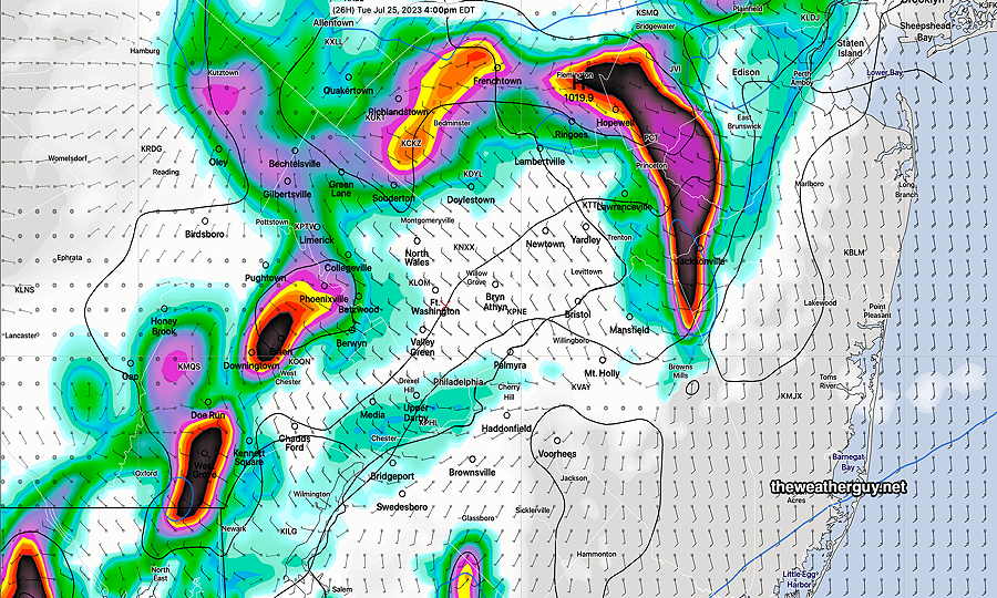
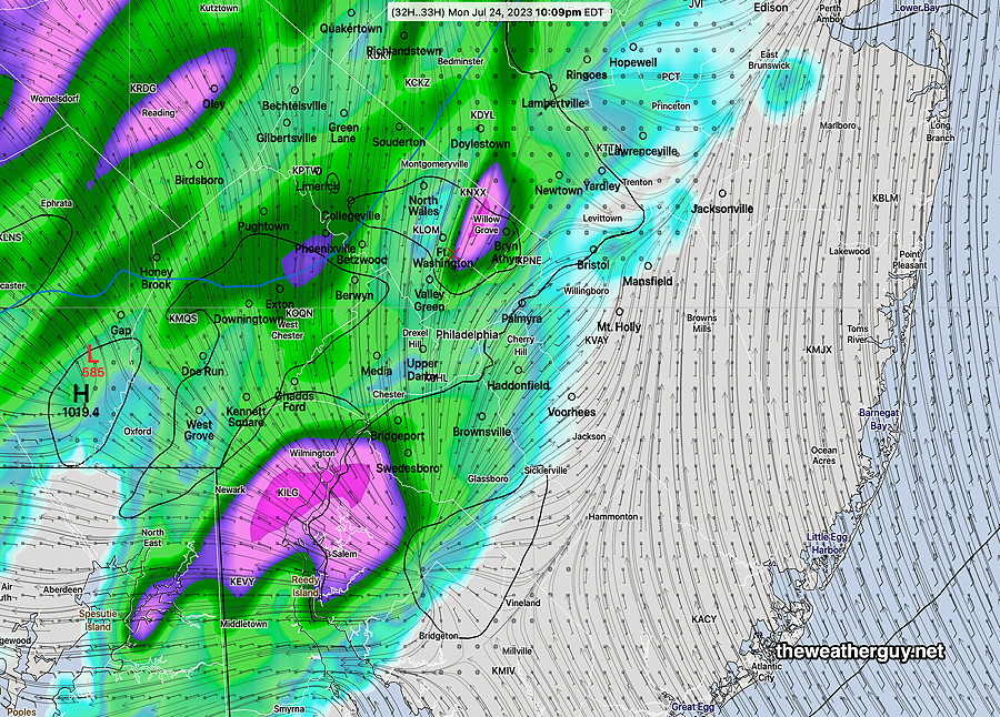
The HRDPS shows greater overall rainfall and more coverage than the HRRR—
HRDPS total predicted rainfall by 7 PM tonight. (Click on image for a larger view.)
I’ll update later this morning, if things change.
Tuesday Outlook
Update Mon 7/24 9:47 PM — Tonight’s HRRR model is suggesting increased likelihood of severe weather Tuesday late afternoon. Updates tomorrow morning.
Updated Mon 07/24 @ 8:40 PM — An upper/mid level trough will swing through our area late afternoon on Tuesday. The usual high CAPE values and high instability parameters will be present.
Helicity is not all that high, so no tornadic activity expected. The standard “strong to severe storms” is the forecast at this time.
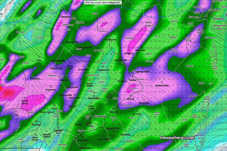
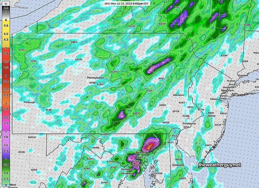
Expect thunderstorms to move in from the west as early as 3:30 PM far western suburbs peaking in the immediate PHL area about 4:30PM to 6 PM.
Today’s 18z HRDPS forecast “precipitation rate” at 4 PM Tuesday. Some heavy downpours in western suburbs. The HRDPS has it weakening as it enters Philadelphia, then regaining strength in NJ. (Click on image for a larger view.)
The distinguishing feature of tomorrow’s storms will be a very strong jet stream presence. This may increase the likelihood of severe weather and strong wind gusts.
I’ll post a severity parameter table tomorrow morning if it looks like it will be warranted.
Monday Forecast Update
Updated Mon 07/24 @ 10:50 AM — Last night’s early models didn’t capture these showers over Philadelphia this morning. Despite that, they are still maintaining a forecast of most (but not all) shower activity stays to our west.
Current radar/satellite—
Water Vapor Monday morning shows additional showers moving up towards Philadelphia from the south. A significant disturbance (circled) will move to our west (white arrows) this afternoon and evening. Showers possible any time, but mostly far western suburbs. (Click on image for a larger view.)
Of the models out this morning, the HIRESW-MEM2 is probably capturing the shower activity best today—
Today’s 12z HIRESW-ARW MEM2 rainfall forecast through 6 PM Monday. (Click on image for a larger view.)
Yesterday’s HRDPS did pretty well with its forecast (shown below). Unfortunately, I’m having technical problems downloading the last few runs of the HRDPS right now.
Update Sun 7/23 10:43 PM — Tonight’s early models are keeping the showers to the west of the Pottstown area during the daytime hours Monday.
Previously Posted Sun 9:22 PM —
Low pressure moving off the Carolinas and a wave in the mid and upper atmosphere will set off showers and thunderstorms on Monday. Most of the activity is expected west of the immediate Philadelphia area, but some pop up storms are expected here as well.
The latest HRDPS shows this total accumulation and coverage for the showers. Note there is little activity expected in NJ.
Today’s 18z HRDPS showing predicted rainfall through 10 PM Monday. (Click on image for a larger view.)
Timing these showers will be difficult, as always. Some are expected in the immediate PHL area early afternoon and again early evening.
Fri 8:57 AM Forecast Review — The storms came through the immediate PHL area about 4 AM—
While it’s great that no severe weather was reported in our area, it suggests that yesterday’s models had over-stated the severe potential. The general timing was within range, somewhat faster than predicted, especially considering the mesoscale complex line of storms had been moving through central PA at near 30 mph.
As mentioned in my 11:04PM update (below), a few of last night’s 00z had models backed off of the heavy rain. (Actually more than a few- the RAP, HRRR and NAM-NEST, but not the three versions of the HIRESW.)
When dealing with the potential of severe weather, especially late model changes within 6 hours of a weather event, one never knows if any observed late changes in the model forecast are the result of true late changes in conditions or whether they simply reflect inadequate “model spin-up” time.
Such is the state and art of the current numerical weather prediction.
As for today, Friday, a mix of sun and clouds. Some scattered pop-up thundershowers expected from 2 PM to 8 PM as a secondary trough moves through.
Update
Update Thu 7/20 11:04 PM — While a few of tonight’s models have backed off from some of the heavy rain, the high resolution models show some impressively severe dynamics—
HIRESW-FV3. Maximum vertical velocity
Tonight’s HIRESW-FV3 shows extreme vertical motion at 6 AM
Early Friday Morning Storms
Updated Thu 07/20 @ 7:46 PM — A front will move through the Philadelphia area between 3 AM and 8 AM. Strong, possibly severe thunderstorms are possible with this frontal passage. PWATs are in the 2 inch range, meaning heavy rain is possible in a short period of time. Helicity is elevated in NJ – tornadic activity possible. Thunderstorms with hail possible.
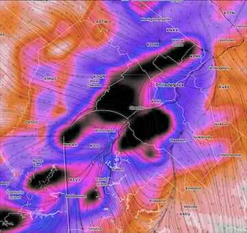
Here’s the latest 22 z (6PM) HRRR forecast for 7 AM —
22z HRRR Surface CAPE and Simulated Radar with Helicity (contours) The red box shows area higher probability of some severe storms. A few areas of high helicity suggest possibility of tornadic activity. (Click on image for a larger view.)
Weak low pressure is expected to form along this front in the Delmarva area, possibly slowing its passage through our area. A secondary trough in the afternoon may bring some additional showers/thunderstorms to some areas.
Severity Parameter Table
HRRR Severity Parameter
Sept 1 , 2021 Tornado Outbreak (example of highly severe)
Recent April 1st 2023 Tornadoes (Example of severe)
07-20-23 Today’s 22z HRRR Forecast
Today’s Impact
Notes
CAPE Joules/kg
3500-4200
2100
1500-2300
⚑
Mostly south and east of PHL
Helicity m^2/s^2
1350
655
360
⚐ ⚐
Southern NJ
Vertical Shear 1/sec
40-46
40-45
29
⚑
Precipitable Water
2.7″
0.83”
2.0″
⚑
Lifted Index º K
minus 6º
minus 9.3º
minus 8.4º
⚑⚑
HRRR Hail inches
1.9
1.4
1.7
⚑⚑
Peak Wind Gusts mph
40-50
40-50
35
⚐
Storm Motion Shear Vector Alignment
Aligned – ~ 90º
Almost aligned
Slightly aligned
⚐
250 mb Jet Stream Wind mph
63
135
65
⚐
Showalter Index (from HRDPS)
-4.4
⚑⚑
Severity Parameters Impact: ⚑ indicates favors Severity ⚐ indicates Possible Severity ↓ indicates works against Severity ⇩ Significant, but less impact
As you can see from my Severity Index table, tonight’s storms have the potential of being severe in some areas with heavy rain.
Thursday Outlook Update
Updated Thu 07/20 @ 10:07 AM — Correction/Clarification: Based on the new morning models, the showers/thunderstorms tonight, now expected between 1 AM and 5 AM, will be the result of a warm front. Showers should end in the morning. The associated cold front will move through during later Friday afternoon, with additional scattered storms. More specifics this evening.
Thursday Outlook Update
Updated Thu 07/20 @ 8:56 AM — A cold front is approaching the region today and there’s some uncertainty with the timing of the rain associated with the front that’s expected later tonight.
The GFS and RAP models have an earlier onset of the showers/thunderstorms: about midnight tonight. The HRRR is slower with the rain: It shows some showers overnight but has a large area of rain moving through mid Friday morning. Total rainfall about 0.75 inches.
The HRDPS is similar to the RAP and GFS forecast: the rainfall starts about midnight to 2 AM.
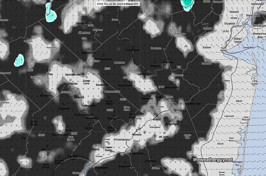
As for the daytime, many models are showing some large areas of cloudiness with breaks of some sun about 2 PM this afternoon. A few very isolated showers possible this afternoon; most areas dry.
Today’s 06z HRDPS cloud cover (black) with showers (green) at 3 PM. The HRRR and RAP models show more extensive cloudiness. Unfortunately, the HRDPS doesn’t show cloud details (high -medium- low — cloud ceiling) as our NCEP models. (Click on image for a larger view.)
More details about the rain/thunderstorms later this evening to follow with an update this evening.
Thursday-Friday Outlook
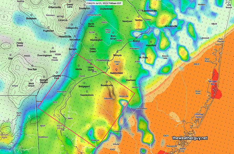
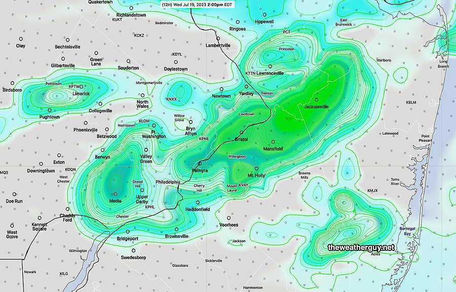
Updated Wed 07/19 @ 8:47 PM —Tomorrow had been forecast to be rainy, but the latest HRDPS shows little in the way of rain or even pop up showers during the afternoon—
18z HRDPS forecast for Thursday afternoon. Little in the way of popup showers. (Click on image for a larger view.)
The front expected to move through on Friday, now appears to come through before daybreak Friday with some showers/thunderstorms. Friday is looking better, but maybe some thunderstorms in the late afternoon.
Wed 8:25 PM Forecast Review — It was clear that today’s model forecasts didn’t do that well. As I stated in my reply to a comment received here, I was looking to be outside this afternoon and I had changed plans due to the model forecast for fairly widespread showers in the mid afternoon. (Even though my own review of water vapor data couldn’t find the impulse to cause the forecast storms, I wasn’t comfortable betting against the model consensus. )
One model that hit the nail on the head today was the Canadian HRDPS model. Our own HRRR model did poorly today, as it did poorly this past Saturday with the overwhelming storms that developed in Bucks county. It should be noted that the HRDPS also did much better with this Saturday’s storms, but was an outlier of sorts.
So why not use the HRDPS all the time? Well, it’s not always accurate either. Sometimes, it’s plain wrong too. The HRDPS forecast extends out only 48 hours. It’s a very complicated model to “post-process”. Because of its heavy post-processing time and because the model comes out about 3-4 hours after its designated run time (due to their own supercomputer speed limitations), the best I can do is see a model that’s already almost 5 or 6 hours old.
Nonetheless, I’ve been impressed with some of its forecasts over the past year, especially regarding cold front passages. If someone can figure out when HRDPS is going to be correct or when the HRRR is going to be correct, we’d have a winning forecast approach.
Updated Wednesday Forecast
Updated Wed 07/19 @ 10:48 AM — It appears that some additional showers are developing just to our west this morning in an area that the RAP model showed as having high moisture convergence—
The predominance of models from this morning show showers developing here by 2 PM, as forecast below in in HREF So my earlier attempt using satellite imagery that delayed showers until this evening just may be too primitive and incorrect.
Updated Wed 07/19 @ 9:36 AM — An area of showers is moving away as I write this and the forecast question for today is when and where will the next impulse set off showers?
The forecast you heard on radio/TV is “scattered showers throughout the day”, a tacit acknowledgement that these things can’t be pinned down. And they likely can’t be. (It doesn’t keep me from trying.) Indeed, the freak downpour that occurred near Washington Crossing, Bucks county on Saturday is a perfect example of the sometimes chaotic nature of weather.
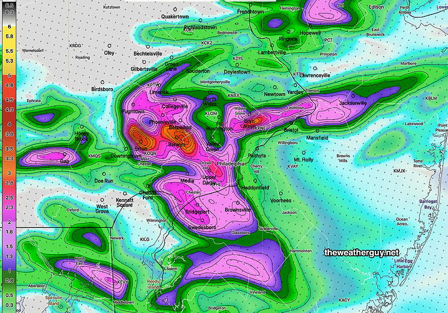
The ensemble models have several areas and time frames for additional showers today. Here’s the current (06z) HREF forecast for 2 PM—
06z HREF 1 hour rain and statistical spread (contours) at 2 PM today. (Click on image for a larger view.)
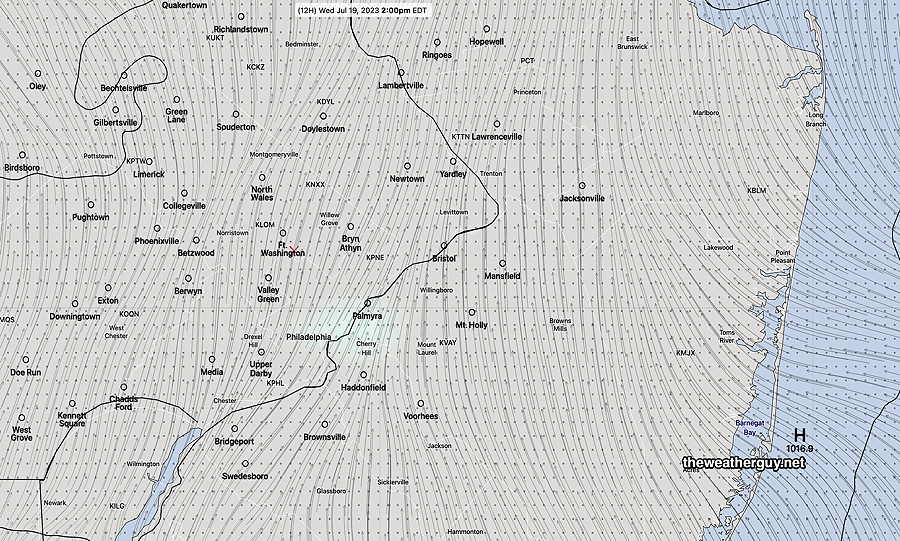
Here’s the current 06z HRDPS which shows almost no rain at 2 PM—
06z HRDPS 3 hour rain forecast at 2 PM. A light shower near Palmyra NJ. (Click on image for a larger view.)
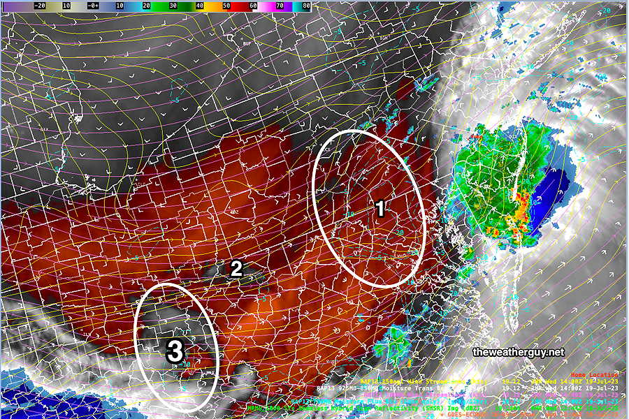
I’m searching the water vapor image for signs of a next impulse—
Water Vapor image at 9:45 AM with superimposed low level moisture convergence. Area (1) shows nothing, but the RAP contours suggest an area of development. Area (2) and especially Area (3) will take about 6-8 hours to reach us. If we go by the water vapor, the next round of showers is late afternoon and evening. (Click on image for a larger view.)
Wednesday Outlook
Updated Tue 07/18 @ 5:49 PM — The storms only developed in NJ today and nothing is expected this side of the Delaware River for the rest of the evening.
Wednesday looks to be unexpectedly “interesting” weather-wise. The cold front that triggered Tuesday’s storms in NJ will return as a warm front during Wednesday.
An area of strong moisture convergence, instability and upward vertical motion will set up near the Philadelphia area.
Showers and thunderstorms may develop as early as 9 AM and will blossom over our area early afternoon. Rain and thunderstorms may linger into the evening hours. Heavy rain is possible with these storms in some areas.
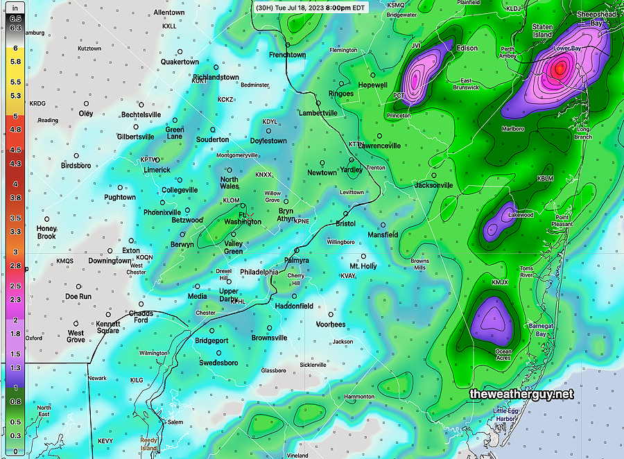
Here’s the latest HRRR forecast for the rain Wednesday—
Today’s 18z HRRR total rain forecast for Wednesday. (Click on image for a larger view.)
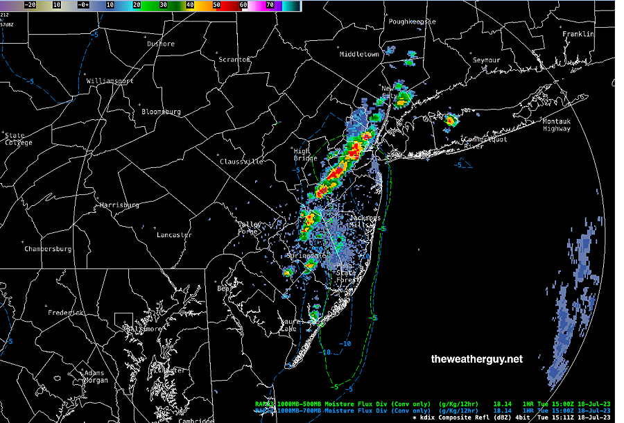
Tuesday Forecast Update
Updated Tue 07/18 @ 11:23 AM —
It’s still late morning (11:23AM) but storms have already broken out in NJ, the area pegged for most of the action today. Based on the RAP model, it appears that the storms have broken out in areas of greatest moisture convergence (blue/green contours). (Click on image for a larger view.)
This morning’s NAM-NEST confines all the activity to New Jersey, even later this afternoon. So maybe nothing for the immediate PHL area.
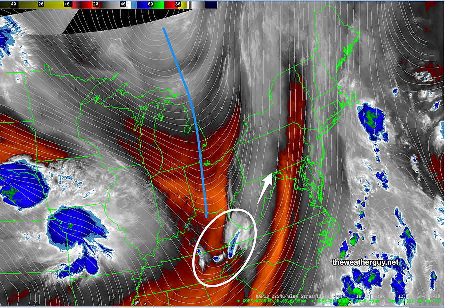
Tuesday Forecast Update
Updated Tue 07/18 @ 8:34 AM — The upper trough and the disturbance that is expected to cause thunderstorms in our area this afternoon are clearly visible on this morning’s water vapor image—
Today’s Satellite Water Vapor image with superimposed 250 mb RAP wind streamlines. The upper trough is the blue line drawn in. The disturbance to set off the thunderstorms is in the white circle. (Click on image for a larger view.)
The trends from last night still remain— the upper air support diminishes as the disturbance approaches. Most of the heavier activity is expected in NJ. Some dry air filters in at some levels and the PWAT is reduced.
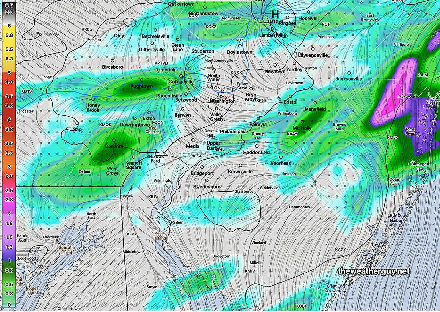
Here’s the HRDPS depiction of the rain coverage—
The HRDPS still has some storms as early as 2-3 PM, now in western suburbs. Groups of storms will be disorganized, not necessarily a line of storms. Some areas may see nothing at all. Some scattered activity lasting to about 8 PM in our immediate PHL area.
Some storms that do form may be strong to severe. CAPE values still moderately high and instability values are highly elevated.
Update Mon 7/17 9:50 PM — Just a quick update. Tonight’s early models are forecasting a weaker frontal passage and dry air moving in Tuesday afternoon. This would significantly decrease the chance of thunderstorms Tuesday.
Check back tomorrow morning .
Tuesday Thunderstorms
Updated Mon 07/17 @ 8:48 PM — First let me say that the HRRR smoke model is forecasting for tonight to have the most smoke pollution in this area and things improve Tuesday.
A cold front moves through sometime Tuesday afternoon or or early Tuesday evening. There are large differences in the timing of the front, with the HRDPS having early to mid afternoon storms here, moving into NJ later in the afternoon.
There are also giant differences in forecast PWAT, with the HRDPS having values near 2.2″ while the HRRR is in the 1.6 to 1.9″ range.
The NAM and HRRR have most of the activity late in the afternoon and early evening. Most models seem to have the greatest activity in NJ.
There isn’t much storm activity forecast for the western suburbs of Philadelphia, so at the current time it appears that the areas from Philadelphia and especially east into NJ will be the most impacted, with NJ possibly receiving the heaviest rainfall.
The latest HREF model captures this emphasis of having most of the activity east into NJ—
Today’s HREF total precipitation forecast by 8 PM Tuesday evening. (Click on image for a larger view.)
There will be plenty of CAPE and somewhat elevated vertical shear Tuesday. Storms could be strong to severe. If the PWAT forecast by the HRDPS is correct, some of the storms could again produce local flooding.
We’ll have a better handle on this tomorrow morning.
Outlook and Monday
Previously Posted Mon 10:09 AM —
A persistent pattern of an upper low in Canada and a high pressure dome in the Southwest US will continue this week with some flattening of the upper trough in the center of the country. Disturbances continue to flow over and around the heat dome and around the upper low.
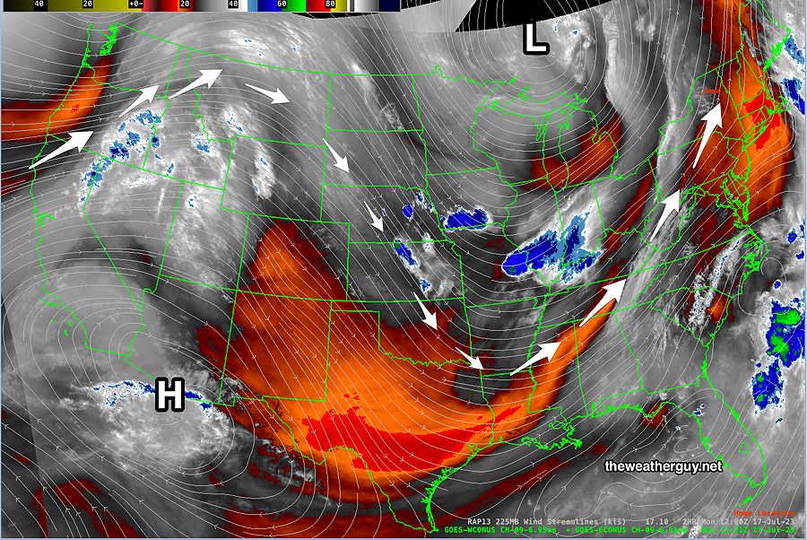
Here’s what the upper levels look like today —
Monday Water Vapor Satellite Image with superimposed RAP model 250 mb (jet stream level) wind streamlines. The dip (trough) in the central US should flatten out somewhat this week, but disturbances in the upper flow (blue areas) will continue to rotate towards us, with a risk of showers on some days. (Click on image for a larger view.)
For today, Monday, high pressure will bring mostly sunny skies and hot temperatures. Highs 90-91º Dew points in the tolerable mid 60s.
As the dip in the jet flow moves east, a cold front will move through on Tuesday afternoon. Another disturbance in the flow will spawn low pressure here on Thursday with more showers/storms possible.
Updated Fri 06/30 @ 7:36 AM — Some smoke is still expected to be impactful today, with improving conditions Saturday.
Here’s the latest HRRR smoke forecast for 2 PM Friday—
Today’s 10z HRRR total smoke in column forecast for 2PM Friday. Still noticeable, but nowhere near the levels of early June. (Click on image for a larger view.)
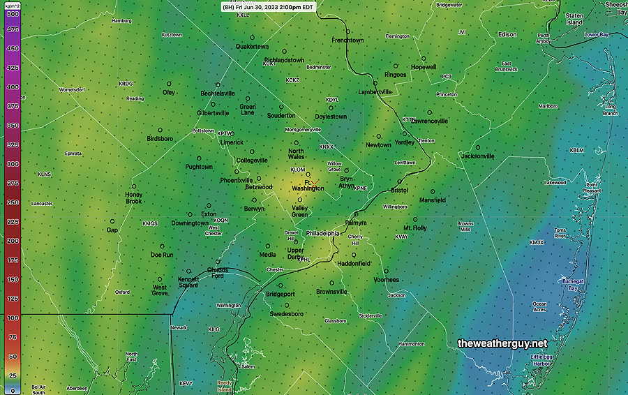
We’re finally getting some warmer temperatures today—
06z NBM high temperatures for Friday (Click on image for a larger view.)
No rain expected daytime hours Saturday, with an increasing chance of light showers during the evening. Sunday is also looking somewhat drier than previously forecast; still uncertainty around Sunday’s forecast. Check back later this afternoon for my weekly “Weekend Weather Forecast”
Friday and Saturday Outlook
Updated Thu 06/29 @ 6:18 PM — Friday looks to be sunny with less smoke. Saturday is looking much better than previous forecasts—The latest GFS has no showers during the day, sunny skies with a few periods of cloudiness. Look for updates.
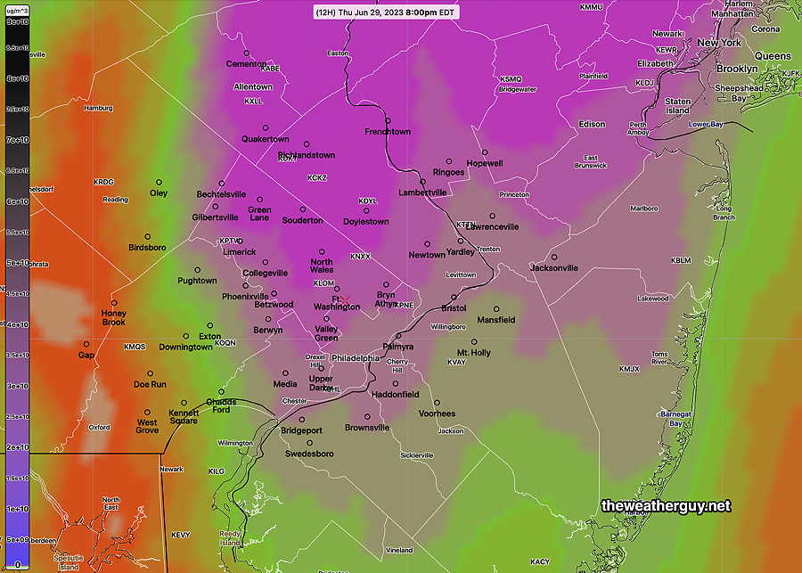
Updated Thu 06/29 @ 10:17 AM —It will become increasingly smoky here in the Delaware Valley today, although values will be significantly less than a few weeks ago.
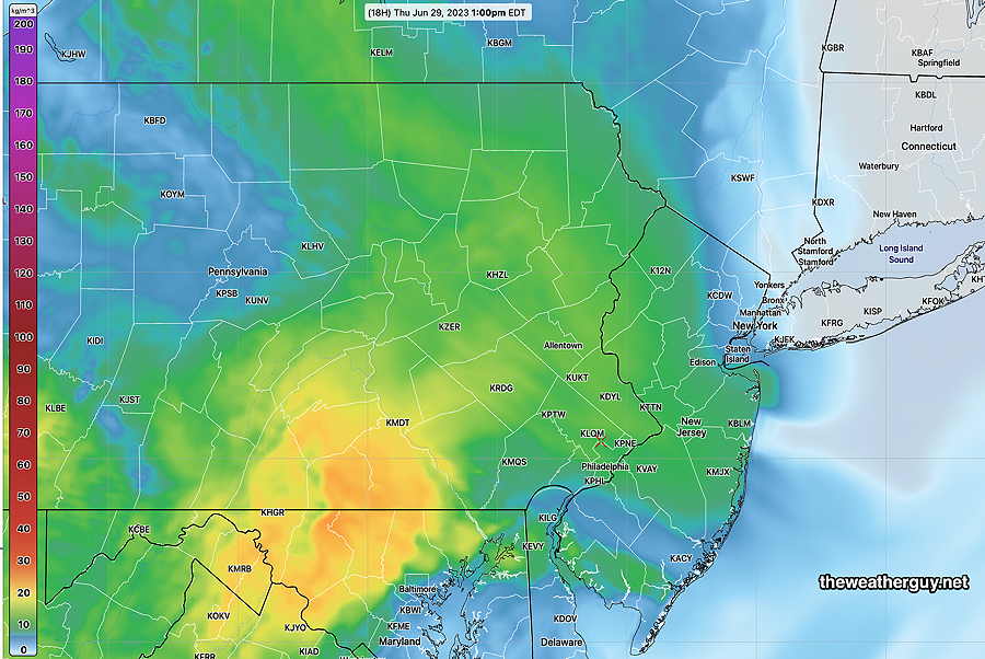
Using the latest HRRR smoke forecast—
HRRR smoke level at mid to lower level of atmosphere Thursday at 8 PM. (Click on image for a larger view.)
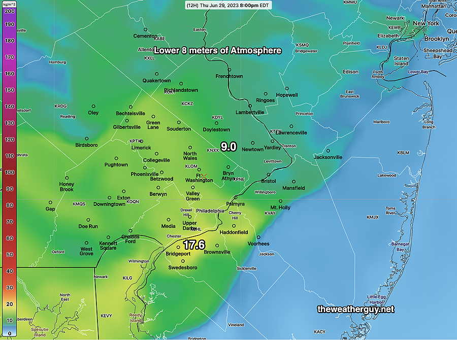
At near ground level (8 meters or 27 feet). ( A few weeks ago we were at 190!)
HRRR smoke integrated column up to 8 meters above ground for Thursday 8 PM. (Click on image for a larger view.)
Thursday-Friday Forecast & Weekend Outlook
Updated Wed 06/28 @ 9:32 PM — A nice day on Thursday. Plenty of sunshine and high temperatures in the low to mid 80s. Some increased smoke to contend with tomorrow.
Smoke level near ground tomorrow – 11 compared to 190 a few weeks ago. Still quite noticeable—
23z HRRR smoke model forecast for 1 PM Thursday. Still at the low range here, but the smoke will be more noticeable than it was Wednesday. (Click on image for a larger view.)
Friday will be very warm to almost hot. Mostly sunny, but some cloudiness at times, increasing in the afternoon. High in the upper 80s.
Saturday will have considerable cloudiness with showers early morning and again in the late afternoon. Much cooler.
Sunday will be warmer but with rain and thundershowers at times during the day. Possibly the most rain of any day this extended weekend.
Monday and Tuesday, the 4th, will have plenty of showers and clouds, some sun, warmer and more humid.
Check back for details on the smoke situation tomorrow morning.
Wednesday Forecast Update
Updated Wed 06/28 @ 9:40 AM — Each model has varying degrees of cloudiness and sunshine today. A mix with more sunshine after 2 PM according to the latest NBM, but I would say today’s cloud cover forecast is a lower than average confidence.
Little in the way of scattered showers, mostly far northern areas.
The weekend is still looking unsettled and somewhat wet as we will be north of a diffuse boundary separating very hot humid air to our south and somewhat cooler air over us and to our north.
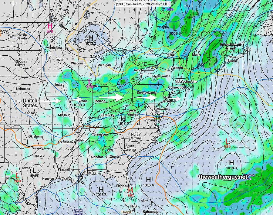
Low pressure systems are expected to move along this boundary, from late Friday through at least Sunday—
NAEFS Mode version forecast for 2 PM Sunday. (Click on image for a larger view.)
Wednesday Forecast
Update Tue 6/27 11:00 PM —Even more sun on Wednesday than previously forecast.
Updated Tue 06/27 @ 8:11 PM — Wednesday looks better than the past two days. Some sun possible in the morning, mostly western suburbs, then considerable low clouds at times with some sunny breaks in the afternoon. A few very widely scattered sprinkles move through during the afternoon. Most areas will not see a sprinkle
Hard to believe, but the weekend is looking fairly unsettled with rain at times.
Tuesday Forecast Update
Updated Tue 06/27 @ 5:26 PM — The earlier arrival of the storms as predicted by the high res models was closer to reality. Additional activity may move in and intensify from now until 7 PM here in Philadelphia.
Radar and RAP model data at 5:16 PM (Click on image for a larger view.)
Tuesday Quick Forecast Update
Updated Tue 06/27 @ 11:39 AM — A quick update based on this morning’s high resolution models. Most models this morning have showers moving in as early as 3 PM -4 PM (3 PM western suburbs) with peak activity 5-7 PM in the immediate Philadelphia area.
Unlike yesterday, these storms will move through New Jersey.
Unlike yesterday, these storms will be moving from west to east instead of south to north.
• Peak wind gusts 40-45 mph in some areas. • Strong to severe storms, possibly stronger than yesterday. • Hail possible, especially in New Jersey • Forecast is for intensification as the storms approach Philadelphia and the Delaware River and move into NJ.
Tuesday Forecast
Updated Tue 06/27 @ 9:53 AM — Latest HRRR model forecasts showers and thunderstorms moving in as early as 4 PM today. Peak thunderstorm activity expected between 6 and 9 PM.
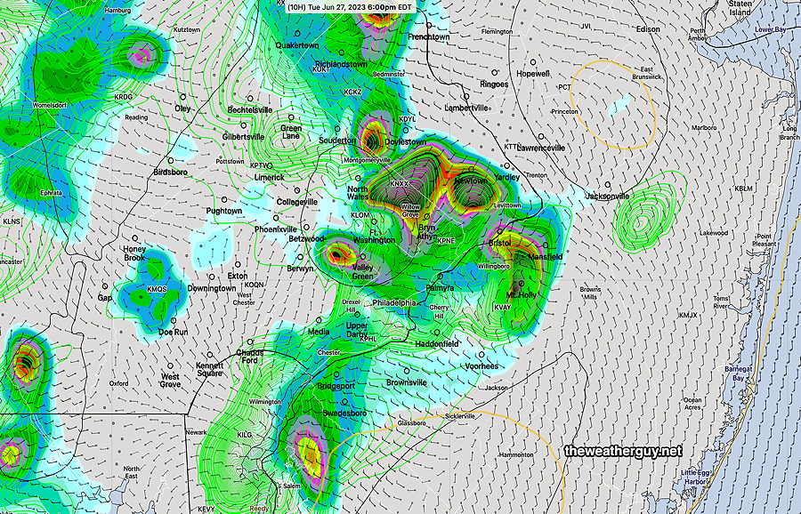
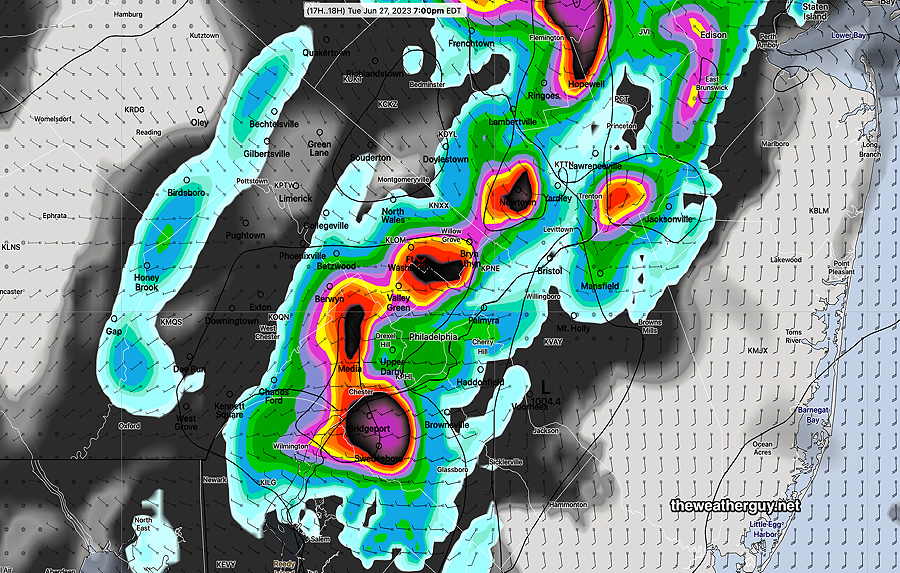
Latest 12z HRRR shows heavy storms at 6 PM, but some break out ahead of the main line as early as 4 PM. (Click on image for a larger view.)
Latest RAP mode has similar early break out storms, but main line of storms moves through at 9 PM—
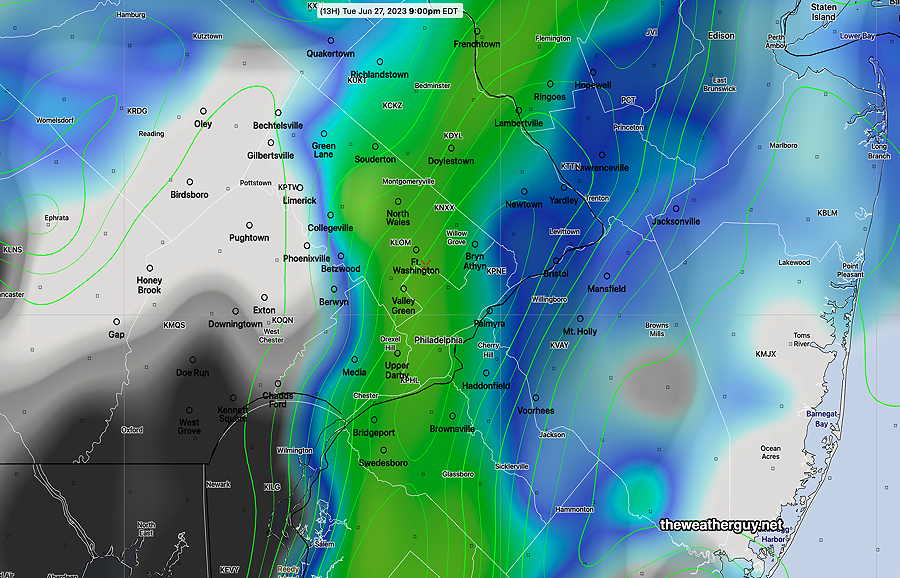
Today’s 12z RAP model simulated radar forecast at 9 PM. (Click on image for a larger view.)
Last night’s 06z HRDPS is right in the middle with a 7 PM maximum—
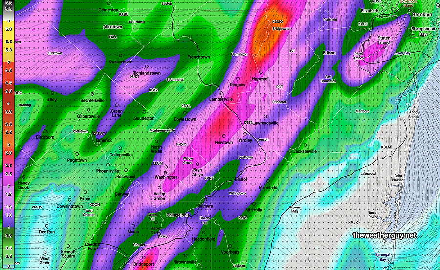
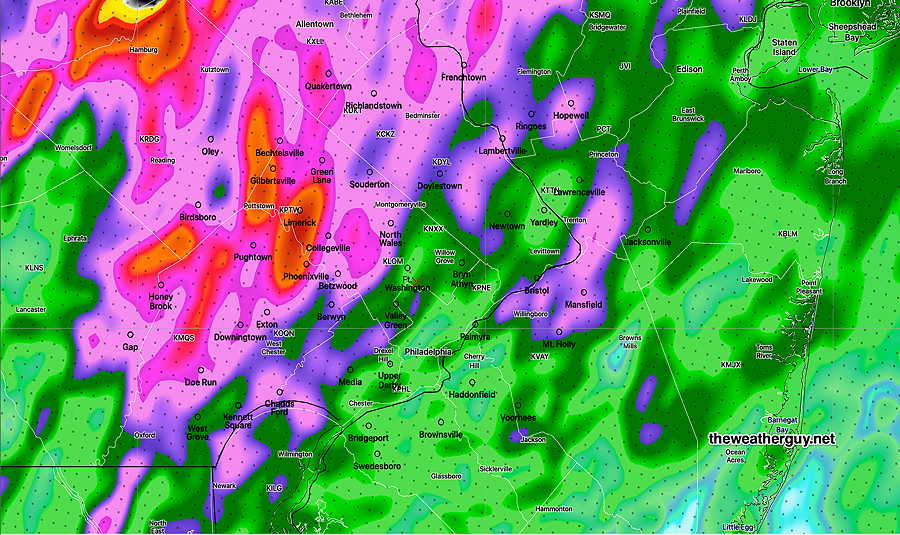
Total rainfall expected
HRDPS total rainfall expected (Click on image for a larger view.)
Monday night update
Updated Mon 06/26 @ 9:31 PM — The main group of storms is poised to move into the immediate Philadelphia area with the next hour or so. Some of these storms are expected to be strong, possibly severe. Not much of this activity is expected to cross into New Jersey and eastward.
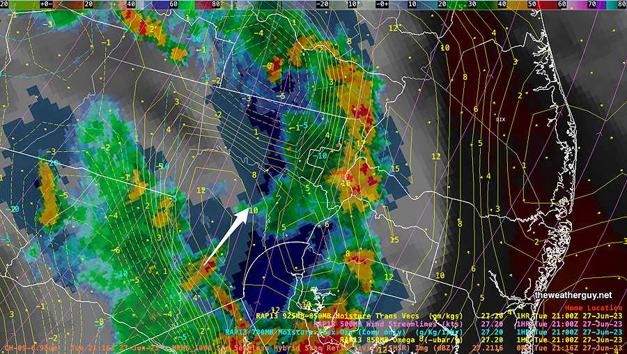
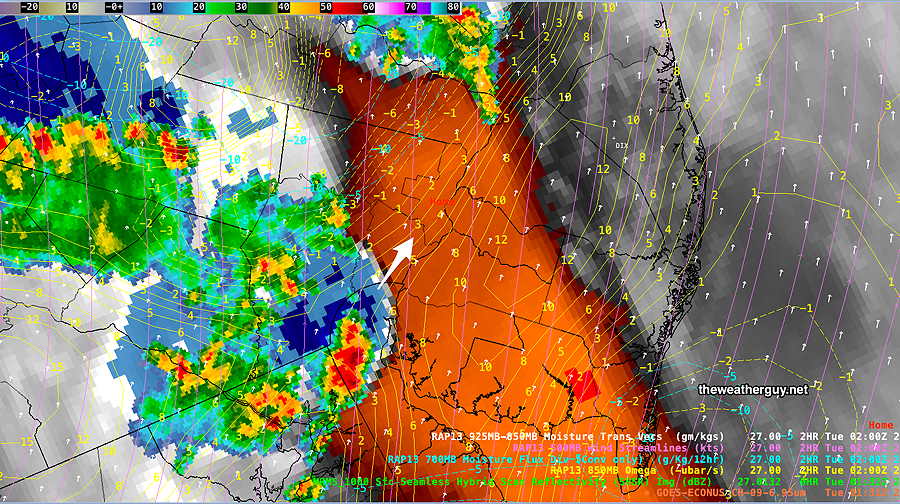
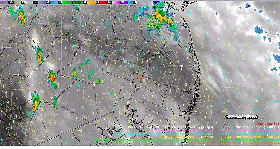
Radar/Water Vapor Image at 9:32 PM—
RADAR- Water Vapor Image at 9:32 PM Arrow shows direction of moisture transport. Yellow contours are Vertical Velocity Pressure (omega) which favor intensification. (Click on image for a larger view.)
I don’t think the model forecasts were very good today. One bright spot— they had correctly predicted that little activity would move into South Jersey.
More storms expected Tuesday afternoon about 4-5 PM according to the latest 00z HRRR.
Update
Updated Mon 06/26 @ 5:16 PM — Latest NAM-NEST just available shows the heaviest rain and storms tonight in western and northwestern suburbs—
This afternoon’s 18z NAM-NEST shows the heaviest rains tonight in affecting western and northwestern suburbs.
The NAM-NEST shows several groups of storms, an early group about 6-7 PM and a second large group moving towards Philadelphia between 8 PM and midnight. The western suburbs get the heaviest activity.
Problematic Forecast
Updated Mon 06/26 @ 4:15 PM — I’m looking at the latest HRRR and the live water vapor image. I have this terrible feeling that this afternoon’s forecast has been all wrong.
Most of the activity for the afternoon have moved off to our northwest and there’s activity currently in NJ that was not forecast to occur at this time.
Water Vapor at 3:45 PM. The activity has moved off to our northwest. There is strong Vertical motion in (Click on image for a larger view.)
So the first cluster of storms forecast for 3-5 PM isn’t happening here.
The main activity is now expected this evening.
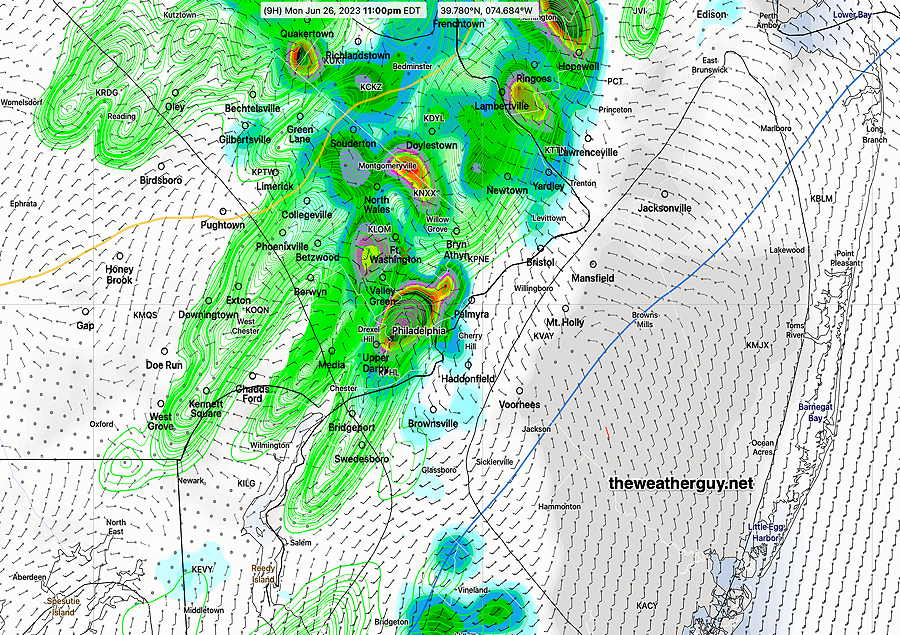
The latest HRRR has the second main cluster of storms (9 PM to midnight mentioned earlier) still moving through. Here’s the updated HRRR forecast for 11 PM—
18z HRRR shows a second batch of storms reaches Philadelphia closer to 11 PM. (Click on image for a larger view.)
Monday Storm Update
Updated Mon 06/26 @ 12:45 PM — After reviewing this morning’s high resolution models, here’s what I see happening today—
The models are not capturing this event all that perfectly. Many models have been showing storms developing this past morning that have not materialized.
Strong and or Severe storms still likely, but will occur as several groups or clusters rather than a single line of storms.
Severity parameters all highly elevated, except for vertical shear values. High vertical shear keeps the storms moving intact and intensifying. These may affect areas, fall apart, then re-form.
First cluster about 3-5 PM that lingers. May not move into NJ.
Additional clusters, mostly west of Philadelphia and near the city early evening.
Additional storms 9 PM to midnight. which may diminish in intensity as they enter into NJ.
Wind gust near 40-45 mph in some isolated spots. Most areas with wind gusts in the 30-35 mph range.
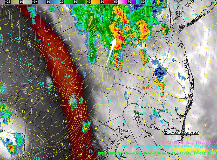
Most models are suggesting that the storms reaching eastern areas in NJ will decline in intensity or fall apart.
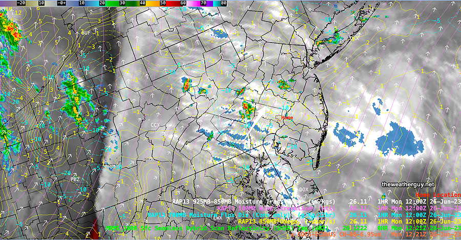
Water Vapor at 1 PM with superimposed RADAR and RAP model Omega values (yellow contours). Storms are poised to form in western suburbs shortly. These storms will form in clusters, some dynamically in place, rather than a moving line of storms. (Click on image for a larger view.)
Monday Morning Update
Updated Mon 06/26 @ 9:42 AM — The latest 12z HRRR just available. Here are the latest changes. Storms move into and develop in the Philadelphia area earlier, about 3- 5 PM. Another line of storms moves through between 9 and 11 PM.
I don’t see the 60-70mph wind gusts being advertised in the immediate PHL area, only near Allentown and south into Maryland. (Always listen to the NWS for these details.)
The storms will be more scattered and clustered instead of a distinct line that moves through.
More updates sometime around 1 PM, after all the 12z models have come in.
Heavy Thunderstorms Forecast Monday
Updated Mon 06/26 @ 8:49 AM —The media has been all over the forecast for severe weather today. So what’s going on?
A prefrontal trough, currently located in western Pennsylvania, will move through our area this evening. (The actual cold front will come through tomorrow.)
The trough is visible in satellite water vapor imagery this morning—
Prefrontal trough at 8 AM today is visible in western Pennsylvania. A prefrontal trough is a wind shift line with significant moisture convergence and strong dynamics.
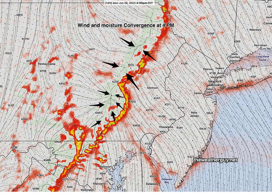
A prefrontal trough is a distinct wind shift line with significant moisture convergence and strong vertical dynamics. Here’s the NAM-NEST position of the trough and moisture convergence at 4 PM—
NAM-NEST 4PM forecast for horizontal moisture convergence (red-yellow) and wind convergence. (stream lines and black arrows) (Click on image for a larger view.)
Current Timing of Today’s Storms
Based on the current water vapor image, some showers and thundershowers are possible this morning, especially in Bucks county and far western suburbs, but a shower anywhere can’t be ruled out this morning.
With conditions as unstable as forecast, some storms will break out again after 3 PM. The main line of storms is forecast to move through about 7-9 PM, an hour or so earlier in western suburbs. Some storms may linger as late as midnight.
It’s unclear how far any extreme weather will move east into New Jersey. Most of the current models have the main dynamics moving towards Philadelphia but affecting mostly western and northern suburbs. This may change.
How Severe?
HRRR Severity Parameter
Sept 1 , 2021 Tornado Outbreak (example of highly severe)
Recent April 1st 2023 Tornadoes (Example of severe)
Today’s 06z HRRR Forecast
Today’s Impact
Notes
CAPE Joules/kg
3500-4200
2100
2500
⚑⚑
Helicity m^2/s^2
1350
655
240
↔ ⚐
High near Allentown
Vertical Shear 1/sec
40-46
40-45
12
↓ ↓
Precipitable Water
2.7″
0.83”
1.9″
⚑
Lifted Index º K
minus 6º
minus 9.3º
minus 9.4º
⚑⚑
HRRR Hail inches
1.9
1.4
1.5
⚑
Peak Wind Gusts mph
40-50
40-50
42
⚑
far Western areas
Storm Motion Shear Vector Alignment
Aligned – ~ 90º
Almost aligned
opposing direction
prefrontal trough
Unknown affect
250 mb Jet Stream Wind mph
63
135
53-75
⚐
far Western areas
Severity Parameters Impact: ⚑ indicates favors Severity ⚐ indicates Possible Severity ↓ indicates works against Severity ⇩ Significant, but less impact
As we can see, far western areas (western Chester counties, Berks and Lehigh counties will be most affected. Areas north of Allentown may see possible tornadic development.