Saturday Forecast Updated Sat 10:39 AM highlighted below Sunday Forecast Updated Sat 6:10 PM highlighted below
The coming weekend’s weather will be influenced by an upper air low pressure system, the residual tropical moisture in place and the moisture and eventual track of tropical storm (hurricane) Henri.
The Weekend Forecast
The weather this weekend is dependent upon the track of Henri. Even without Henri in the picture, the tropical moisture in place with the upper level low would give us a good chance of clouds, showers and thunderstorms. The weather with upper level closed lows are notorious for being difficult to forecast.
Saturday
A mix of clouds and sunshine in the morning. Showers and thunderstorms develop as early as 2-3 PM. The showers on Saturday are looking very scattered. Large model differences in location. Localized rainfall may be heavy. High temp 84.9º ± 2.1º NBM model, Blue Bell.
Sunday
Cloudy with showers/rain. Gusty winds likely. The amount of rain and wind will depend upon the track of Henri. Potential for heavy rain at the shore.High temp 83.6º ± 2.3º The NBM cranks out several inches of rain for our area. The GFS less than 1″ Will need to update later this evening.
High temp 79.4º ± 3.1º NBM model, Blue Bell.
I will be updating the forecast over the weekend. Check back for updates.
For the past two weeks, the weather models have been not been at their best. I’m not sure why. Most of the models have been updated since the fall (HRRR, RAP, NBM, HIRESW, HREF and GFS) and this is their first summer hot season. Clearly, there’s something wrong, as they are not handling very hot weather and convective activity accurately.
I haven’t been able to find any public discussions or presentations from the scientists at NOAA in the “Model Diagnostics and Verification Group”. One thing to notice— new model development is conspicuously missing from their website.
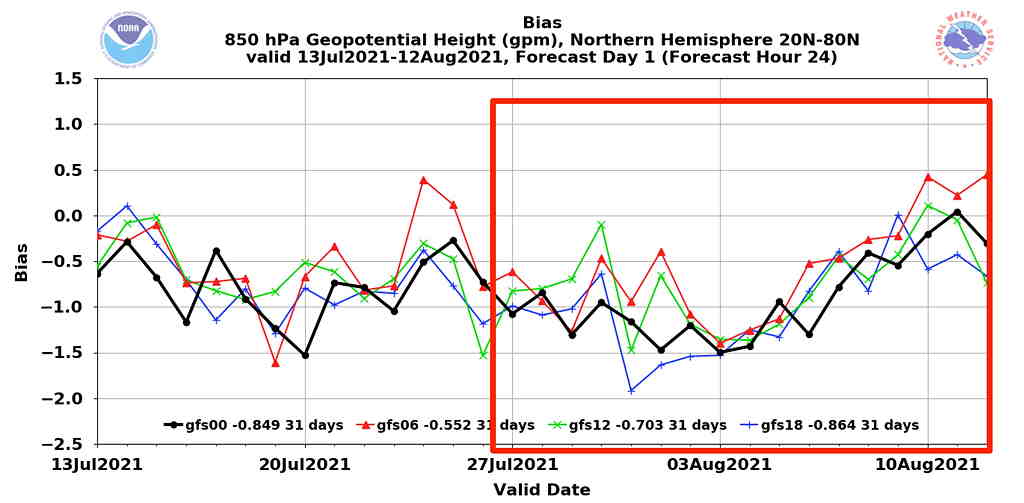
Here is the current GFS bias error (comparison of forecast to observed measurement) for the past two months. Notice that over the past 10 days, the negative bias error has been greater than average. (no surprise here!)
GFS Bias error temperature at about 5000 feet. Notice how the trend is below the average bias error during the very hot weather. July 20th was also a hot period. (Click on image for a larger view.)
I’m sure the people responsible for evaluating model performance are working on it.
WEEKEND FORECAST:
A cold front will slowly pass through tonight while a secondary cold front moves through Saturday afternoon. The above discussion about model error was ‘inspired’ by the fact that there are huge differences in the forecast for Saturday.
Friday Evening
The approaching cold front will trigger showers and thunderstorms, but most models have the storms diminishing as they approach the immediate PHL area. Some storms may remain intact to our north (Trenton) and just to our south (Wilmington DE). A few isolated storms may sneak through. (Latest GFS hot off the wire shows some rain in Philadelphia 8-9 PM ) Similar to yesterday, they encounter high CIN and a dome of stable hot air. Here’s the latest HREF with its 1 hour rain forecast—
Latest HREF with rain accumulation at 8 PM showing eastward most extent. (Click on image for a larger view.)
Saturday
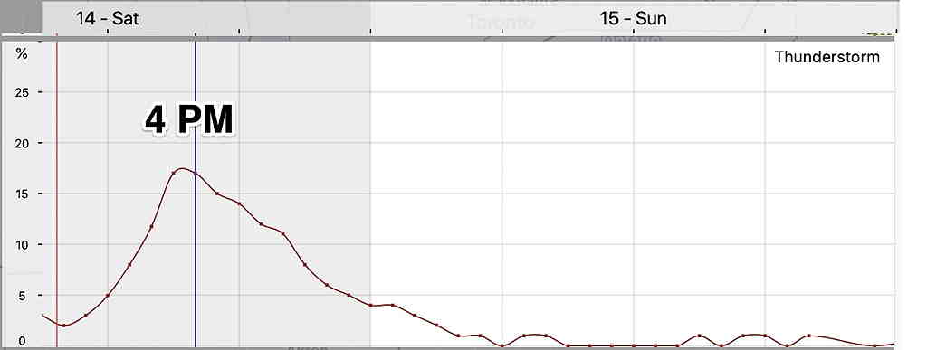
Highest chance of thunderstorms today. (Below 18% is low) Widely scattered and relatively low probability.
The HREF has showers/thunderstorms, scattered,starting at 4 PM and extending into 9 PM. Most of the activity west, east and south of Philadelphia.
The NBM still has a high of 89.4º ± 1.1
Here’s where things get less certain. A secondary cold front moves through between 1-3 PM. Many models have Saturday mostly sunny. The ICON model and the SREF have some showers and thunderstorms with the frontal passage during the afternoon. Additional scattered storms possible in the evening Some models (GFS) are less impressive with the showers/thunderstorms.
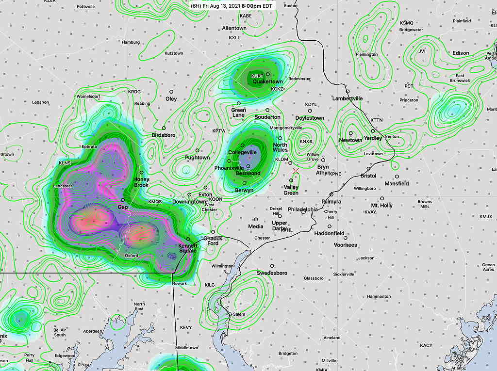
The HREF has showers/thunderstorms, scattered,starting at 4 PM and extending into 9 PM. Most of the activity west, east and south of Philadelphia. Some of the rain will be locally heavy. (With current track record, I wouldn’t put too much stock in the exact forecast placement.) Here’s the HREF forecast for rain (hourly accumulation) Saturday at 7 PM—
HREF hourly rain accumulation 7 PM. Some of the rain may be locally heavy (Click on image for a larger view.)
Sometimes, the best forecast is to indicate that forecast is uncertain and lower than usual confidence.
Sunday
Forecast Update Sun 10:45 AM The front that moved through Friday has stalled to our south.
Moisture from this stalled front is moving northward. The three versions of this morning’s HIRESW model all maintain some degree of high and mid-level cloudiness through noon and then considerable high level cloudiness in the afternoon with some sun filtering through. Next week looks very unsettled as tropical storm remnant moisture will move in to our area.
Sunday updated forecast. Little change. Clouds give way to partly sunny to mostly sunny. High 85º. Next week looks very unsettled as tropical storm remnant moisture will move in to our area.
Sunday looks to have some cloudiness in the morning, especially south of the city, becoming sunny and cooler. NBM high temp 84.1º ± 2.0º.
Sun 08:48 AM Forecast Review — As suspected, the GFS forecast with its earlier clearing and minimal rain, was far superior to the higher resolution models’ forecasts. In fairness, the HIRES models did show the earlier clearing in last night’s runs. Today will be mostly sunny, breezy and cooler than previous forecasts. Some instability cloudiness possible at times. The ICON model should be noted as having picked up the early trend of temperatures in the low to mid 80s.
I’m always looking to find the best way to offer the most transparency to the process of weather forecasting. Recent feedback suggests that my attempts to show all updates/edits may have made the forecasts too confusing.
Going forward, I’m inclined to have any update to the initial post contained in a single update box; previous updates will be deleted. But let’s hear what YOUR preferences are before I make any changes.
[yop_poll id=”2″]
Thank you very much for your feedback. (Over the past few days, you’ve probably noticed that I’ve been experimenting with a newer format that includes all updates, since that’s where it looks like your preferences lean towards). I’ll be taking down the feedback poll on Monday.
The weekend outlook that I posted on Wednesday has changed from the simple jet stream transition from a trough to a ridge with a warm front.
The trough (dip) in the jet flow seems to want to linger longer than had been expected. Its presence spawns a weak low pressure system late Saturday off the coast of Delaware. The location of this low pressure, both in upper atmosphere and at the surface, differs between models, as does the forecast for Sunday.
The weather on Saturday and Sunday will be much warmer and more humid than its been this past week, but current models are keeping us below 90º with mid 60s dew points for the weekend.
The models are in reasonably good agreement for Saturday. Saturday starts mostly sunny, with considerable high cloudiness that thickens during the afternoon. Skies turn mostly cloudy by late afternoon. High 88.2º sd 2.1º (NBM Blue Bell)
Saturday Forecast Updated Sat 7:40 AM — Lower level clouds move in Saturday about 1-3 PM
Showers move into South Jersey and perhaps into Philadelphia after 11 PM Saturday evening.
Sunday Forecast Update Sat 9:45 PM — Tonight’s models continue with the idea of less rain and clearing by noon, especially from Philadelphia and westward. The latest NBM joins the ICON model forecast from Friday in predicting a high of only 83º but with a very high sd of 4.4º (uncertain)
NBM Sunday 00z forecast (clouds- dark shading) (rain- green blue) for noon on Sunday. (Click on image for a larger view.)
Sunday Forecast Updated Sat 6:30 PM — This afternoon’s models have speeded up the clearing and have the low pressure system somewhat further east. There’s still a difference between the high resolution models and the GFS but I’m leaning towards the GFS. So expect less (or no) rain showers during the night and more sun and less cloudiness on Sunday.
Sunday Forecast Updated Sat 7:40 AM — Last night’s models continue with the dichotomy of forecasts. The GFS maintains the upper level low, but still has skies clearing by late morning with minimal showers in PHL and west. The HIRES models vary, but maintain showers and clouds in the morning. The NBM has taken the middle ground, with some scattered showers in the morning, with clearing by afternoon. (Note that all models have significant rain for the southern Jersey shore, clearing late.)
Forecast Updated Fri 10:10 PM — Tonight’s high resolution models continue with clouds and scattered showers on Sunday.
Forecast Updated Fri 8:10 PM — Sunday may be cooler than previously forecast, with northeasterly winds and some clouds. The ICON has a high of only 82°.
Things are more complicated for Sunday. The models differ with regards to the strength of the upper low and the position of the weak surface low.
HIRESW Model 11 AM Sunday
GFS Model 11 AM Sunday
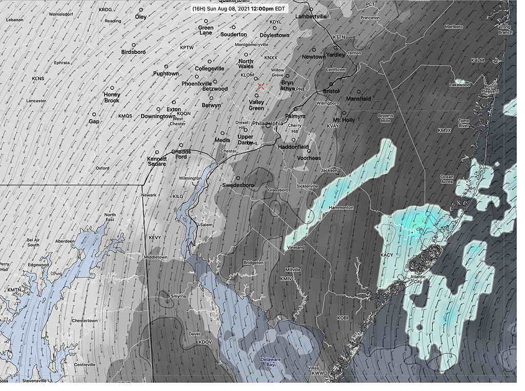
The high resolution models, including the new HIRESW-FV3 and older NAM-NEST, maintain clouds and showers into Philadelphia and eastward during the morning with slow clearing, while the GFS clears things out by noontime. The GFS has little in the way of any rain making it westward or northward of Philadelphia.
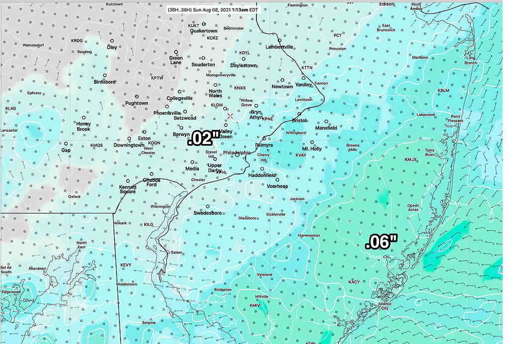
NBM model 1 hour total rainfall at 1 AM Sunday. This is as far north as the showers get. Note that this amount in Philadelphia north and west, will keep your lawn thirsty. (Click on image for a larger view.)
The GFS, despite its relatively low resolution, has done really well lately, so I’m leaning towards its optimistic forecast for Sunday— clouds in the morning give way to a mix of sun and clouds. The model blend (NBM) also has things clearing out. High temp 88º sd 2.1º (NBM Blue Bell)