Overview: A semi- tropical type storm in the Atlantic brought an easterly damp flow to us on Friday. That low pressure system will depart Friday night.
High pressure will build in with a southwesterly flow that will bring warm temps on Saturday, but a weak front will move through during the afternoon.
GFS 5 PM upper air wind/contours and areas of mid levelvorticity (1) (concentric circles) with weak front move through on Saturday, setting off isolated light showers mostly west of the city. Most areas dry. (Click on image for a larger view.)
Saturday
Mostly sunny, occasional brief periods of low clouds both in the morning and afternoon. A slight chance of isolated showers, especially north and west of Philadelphia in the mid to late afternoon. Most areas dry. Warm and somewhat humid. High temp 84.2º ± 1.3º NBM model, Blue Bell.
Sunday
Sunny and and pleasant. Much less humid. High temp 80.5º ± 1.8º NBM model, Blue Bell.
The Week Ahead
Autumn arrives next week. Close to schedule, in the Wednesday to Thursday time frame, will be the arrival of a strong cold front. Some interesting weather possible with this front.
In the same time frame, the ICON model, for several model runs, has been forecasting a coastal tropical-type low pressure system moving up the coast with a sharp dip in the jet-stream. The Canadian Global GEM and to some extent, the GEFS, show a somewhat similar development, but they differ considerably in the extent of development and sharpness of the developing jet trough.
Interestingly, a derived parameter called the 1000-500 mb thickness line (specifically, the 540 dm line) (the winter-time rough determination of the rain-snow line) makes its first appearance in several months on our weather maps next week.
ICON model forecast for 8 AM Wednesday. Red line is the “1000-500mb : 540 Thickness line” (Click on image for a larger view.)
Overview: We’re entering a [much needed] tranquil period of weather for the next several days, as the upper air flow flattens out (“zonal flow”) by Sunday and surface high pressure moves into a position to provide southwesterly flow of warmer air.
Saturday
High pressure almost over us will provide mostly sunny skies. As the upper air flow flattens, a weak upper air disturbance may bring a brief period of cirrus cloudiness during early afternoon, mostly NW of the city. High temp 78.2 ± 0.8º (NBM model Blue Bell PA)
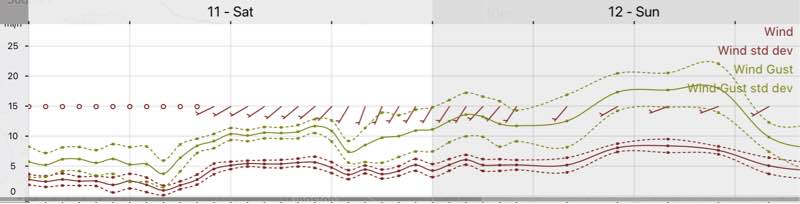
High pressure moves to allow warmer southwesterly flow. Mostly sunny, but some ripples in the mid level flow may result in brief periods of high clouds at times. Breezy with some gusty winds at times. High temp 78.2 ± 0.8º (NBM model Blue Bell PA)
NBM Wind Forecast
The southwesterly flow will eventually bring back some summer-like temperatures early next week with highs forecast in the mid-upper 80s and dew points in the upper 60s.
On the very long range horizon, a tropical system may organize off the southeast coast and move up next weekend.
Update Wed 7:45 AM— Good news. Last night’s models have backed off on the helicity values. Risk of tornadic activity low. Other changes: the first “wave” of scattered storms in the afternoon (described in main post) has reduced in likelihood. The main area of showers/thunderstorms moves through around midnight to 1 AM. CAPE values are further reduced at that hour of the night. So extreme weather less likely. Still strong storms expected. Rainfall about 0.6-1.2” possible, locally higher. Wind gusts about 30 + miles per hour. I’ll update later this morning when the newest models become available.
Update Tue 10:25 PM —Forecast below remains on track. Peak helicity about 8 PM [far] northwest of the city. Second wave of thunderstorms closer to midnight.
A strong cold front will move through after midnight on Wednesday. Thunderstorms, some very strong or severe, will be preceding the frontal passage.
The current models suggest that scattered thunderstorms, some severe, may break out earlier than the main batch of rain. So the storms will come in two waves.
First wave:Widely scattered storms will develop as early as 3-4 PM in areas from Philadelphia north and west. These widely scattered areas of storms ahead of the main front may continue through about 7 PM.
The second wave,the main batch of storms and rain, comes through from about 9 PM through 1 AM. (Remember, I use Blue Bell, PA as the model location grid point.) Rainfall may be heavy in some areas: 1-2 inches of rain.
Following last week’s devastating tropical rain and thunderstorms (and tornadoes) , it’s important to see current model differences between last week’s severe weather and tomorrow (Wednesday).
CAPE values are much higher tomorrow compared to last week, but within range of typical strong/severe storm events.
Regarding tornadic activity, peak helicity values tomorrow are currently forecast less than 350 m2/sec2, significantly below last week’s storms.
(Last week’s tornadoes were developing at helicity levels more than two to three times as high: 800-1000 m2/sec2.) Peak helicity values occur with the second batch of rain and thunderstorms, although there is some significant helicity at 5 PM north of the city. Again, these helicity values are 1/3 that of last week’s Ida event.
I’m providing the following CAPE/Helicity graphics as examples. The location and timing are likely to change in future model runs. Don’t take these locations too literally.
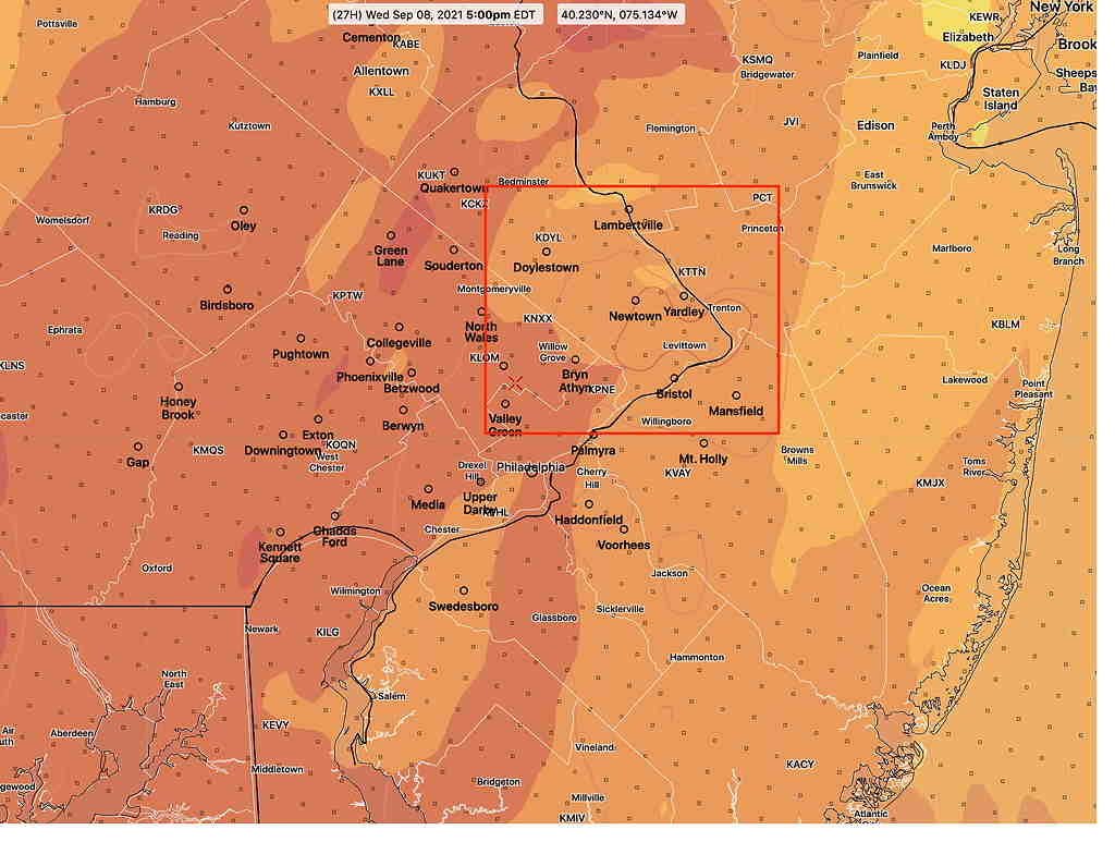
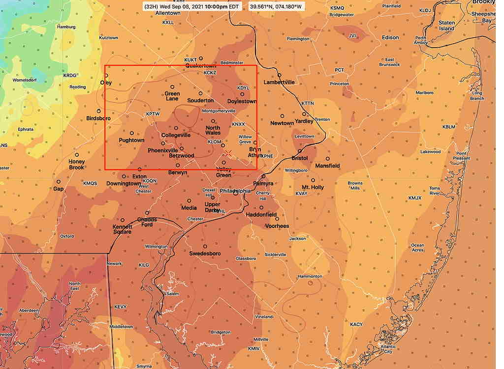
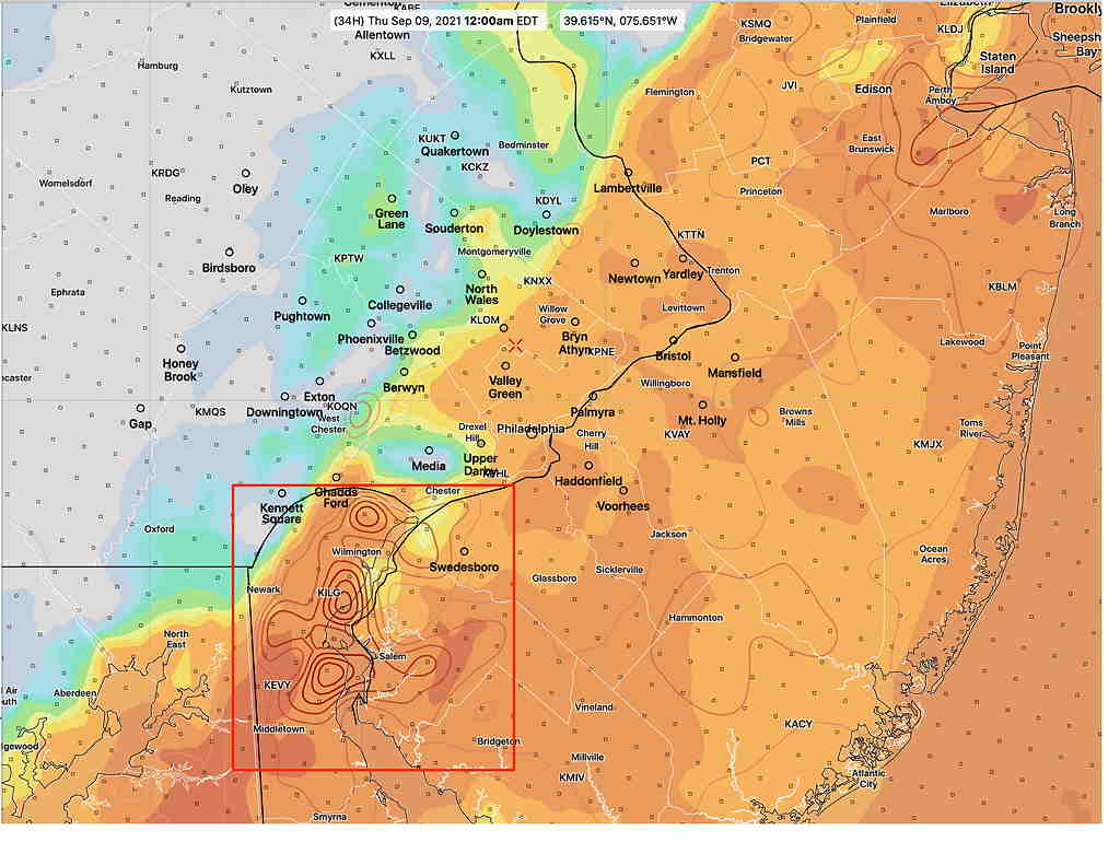
HRRR Helicity and CAPE at 5 PM. Darker is higher CAPE. Contours are Helicity, Peak helicity less than 320 (Click on image for a larger view.)HRRR model Peak CAPE and Helicity at 10 PM (Click on image for a larger view.)HRRR peak Helicity/CAPE at midnight. Peak Helicity 350 (Click on image for a larger view.)
Tornadic activity, if any, will be late afternoon or early evening, with the first batch of energy and again with the second batch of energy, in the 9PM to midnight time frame. But since we’re dealing with life-threatening possibilities, always follow the warnings of the National Weather Service.
I’ll be updating this info tomorrow morning. The next HRRR model run of consequence will become available around 9:35 AM. I’ll try to update then.