
Overview: We’re entering a [much needed] tranquil period of weather for the next several days, as the upper air flow flattens out (“zonal flow”) by Sunday and surface high pressure moves into a position to provide southwesterly flow of warmer air.
Saturday
High pressure almost over us will provide mostly sunny skies. As the upper air flow flattens, a weak upper air disturbance may bring a brief period of cirrus cloudiness during early afternoon, mostly NW of the city. High temp 78.2 ± 0.8º (NBM model Blue Bell PA)
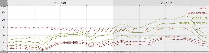
High pressure moves to allow warmer southwesterly flow. Mostly sunny, but some ripples in the mid level flow may result in brief periods of high clouds at times. Breezy with some gusty winds at times. High temp 78.2 ± 0.8º (NBM model Blue Bell PA)
The southwesterly flow will eventually bring back some summer-like temperatures early next week with highs forecast in the mid-upper 80s and dew points in the upper 60s.
On the very long range horizon, a tropical system may organize off the southeast coast and move up next weekend.