Updated Thu 10:34 PM — The forecast continues to evolve for the weekend. First, an upper air wave moving through on Friday will trigger showers and thunderstorms in far northwest areas mid Friday afternoon and these storms will move near the immediate PHL area late afternoon into the evening. Most but not all of the activity northwest of the city.
CAPE values are forecast to exceed 2200 j/kg, so strong storms are possible, but severe not expected.
The front sinks slowly through our area on Saturday. Strong storms and showers possible throughout the day, but late afternoon and evening are the most likely times.
Sunday and Monday are looking better and better. Tomorrow’s Weekend Weather forecast will nail things down
Updated Thu 7:42 AM — The forecast for the weekend continues to improve, as the GFS now shows more spotty precip during the day and the heaviest rain during the evening hours. Most models show clearing by Sunday afternoon. Monday looks good.
Updated Wed 10:03 PM — A cold front will sink towards us late Friday and stall over our area for Saturday and at least part of Sunday as waves develop inducing showers and thunderstorms for Saturday and part of Sunday. Some significant rain for Saturday. The ECMWF is the most optimistic for Sunday, the GFS less so. Things look better for Monday. Stay tuned.
Updated Tue 10:34 PM — Cancel those showers. Tonight’s models have no showers for Wednesday afternoon.
Update Tue @ 9:27 PM — For Wednesday, a weak front (trough) moves through the area late in the day. The models have been back and forth on the chance of showers late afternoon, but the afternoon models are showing a chance of showers between 5 and 8 PM in the northwest and far northwest suburbs.
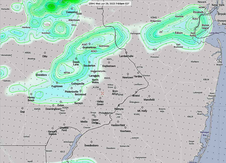
18zHREF shows showers northwest suburbs at 7 PM. Most models keep these north of the immediate PHL area. (HREF 1 hour precipitation + spread in contours) (Click on image for a larger view.)
FYI — Tomorrow, June 28th, the NWS-NOAA will launch its new supercomputers into operation, beginning with the 8 AM EDT (12z) models. The system being upgraded is referred to as WCOSS (Weather and Climate Operational SuperComputer System) The increase in speed/capacity is quoted as 3x the current system.
I’m not sure if this will result in a faster model release schedule (as an example, the 00z GFS currently takes 3 hours 44 minutes to create the first 24 hour forecast, not available until 11:44 PM EDT. It sure would be nice to have that earlier in the evening.)
Surely, new models expected for release in 2023 will be more complex and higher resolution. Exciting stuff!
Update Mon @ 5:48 PM — The balance of the week looks to be fairly nice and increasingly warm. There’s an increased chance of scattered thunderstorms Wednesday evening; otherwise quiet.
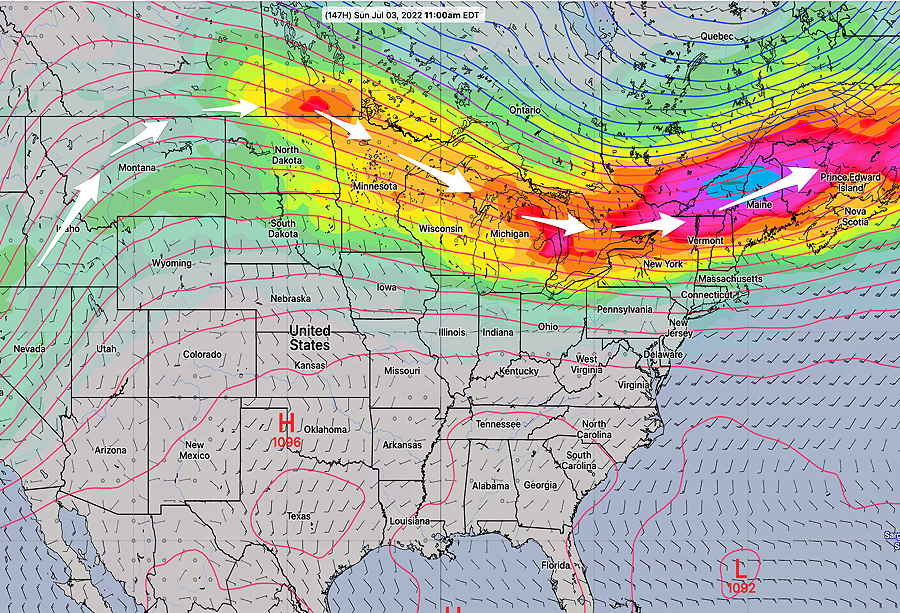
Todays’ GEFS jet stream winds forecast (250mb) for Sunday July 3. A slight cyclonic upper flow will interact with moisture moving up from the southwest. A frontal boundary right over us. (Click on image for a larger view.)
Unfortunately, the weekend may be affected by a front that somewhat stalls out. Current model forecast is that much of Saturday will be OK, but we may have showers and thunderstorms late afternoon Saturday through much of Sunday.
Way too early to hang our hats on that forecast. Monday, the 4th, looks good.
Forecast Review— Overall, most areas had 0.25-.50 inches of rain with several areas in NJ getting over an inch.
Update Mon @ 11:07 AM — The frontal boundary is on schedule with showers and thundershowers expected to enter the immediate Philadelphia area between 12:30 and 2 PM.
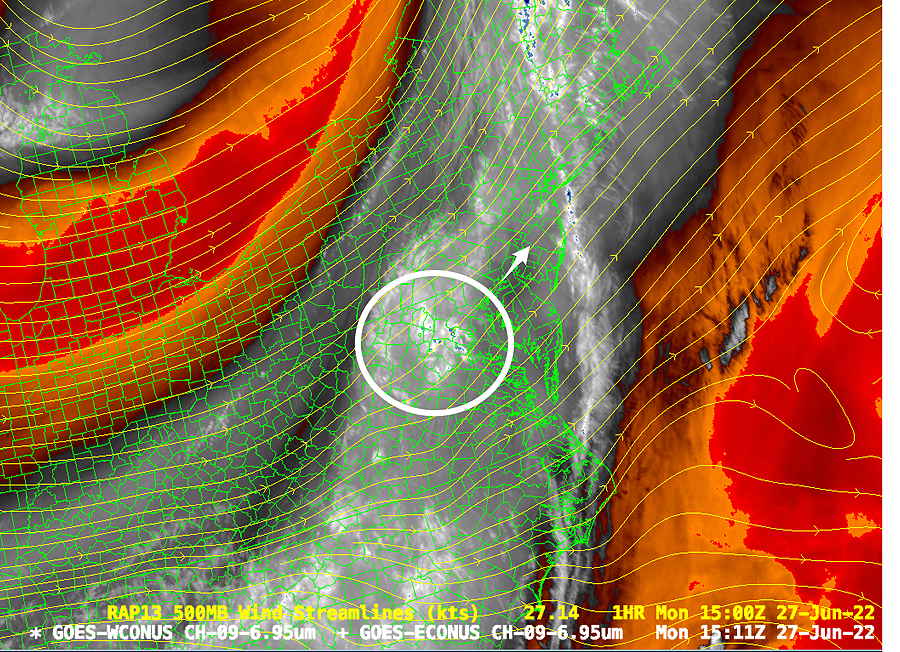
Water Vapor image shows upper air ‘trigger” for some shower intensification this afternoon (Click on image for a larger view.)
Heavy rain in some areas but no severe weather in the immediate PHL area. Stronger storms possible east of the Delaware during the afternoon.
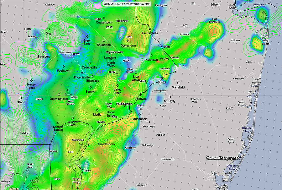
12z HREF 2.5 km showing simulated radar and accumulated rain (green contours) at 2 PM. (Click on image for a larger view.)
Showers should end about 3-4 PM in the city with areas of sun breaking out in some locations.
Updated Sun 11:22 PM — Tonight’s models show thunderstorms of greater intensity as the front moves into New Jersey early afternoon.
Update Sun @ 7:38 PM — Most models show the timing of the front as described below. But, the latest RAP model and GFS have the main wave of the front moving through much earlier. The GFS has showers starting as early as 10-11 AM and the RAP as early as 8-10 AM.
Update Sun @ 5:44 PM — A cold front will move through our area Monday morning through early afternoon with showers and thunderstorms.
The front is likely to come through in two waves— an early period 6-8 AM with very widely scattered showers and storms. Another wave approaches about noon to 2 PM with a more distinct line of showers and thunderstorms. No severe storms expected here. Heavy rainfall (1-1.5 inches) in some locales will be the main impact.
Today’s 18z NAM forecast for 2 PM showing heavier rains (3 hour totals) north of the immediate PHL area as well as southward. Some areas may have 1.5″ rain, some may have less than 1/2 inch. (Click on image for a larger view.)
Since the front is coming through early, daytime heating effects will be minimized. This will reduce the likelihood of any severe weather. The energy with this front is distributed in two waves, also reducing severity. Possibly stronger storms will be nearer the Jersey shore and southward into Delaware.
Updated Sat 10:35 PM — Current Sunday forecast looks good. High temps 90-92°, dew points low 60s. The approaching cold front won’t affect us until Monday morning.
Showers and thundershowers Monday morning and early afternoon with the cold front likely will not be severe in our area. Some areas of heavy rain possible.
The upper air low pressure system will finally move out allowing high pressure and an upper air ridge to move in bringing much warmer conditions, above seasonable average temperatures. (average highs are 83º Blue Bell and 85º Philadelphia)
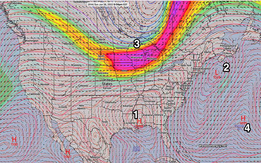
Today’s 18z GEFS shows the upper ridge (1) the upper low (2) and a cold front moving towards us (3) late Sunday. By the end of the week, the typical Bermuda high pressure (4) will move into its usual position bringing more heat and humidity. (Click on image for a larger view.)
Sunny and compared to recent conditions, very warm. Borderline humid with dew points in the mid 60s. High temperature 88.7º ± 2.0º NBM model, Blue Bell PA. There’s a chance of very widely scattered pop-up thundershowers, mostly far northwest of the city during the afternoon.
Sunday
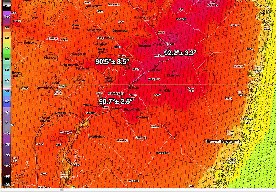
Sunny and somewhat warmer. Lower dew points in the low 60s. High temperature 90.5º ± 3.5º NBM model, Blue Bell PA.
Today’s 19z NBM Model high temperatures Sunday. Black contours are 2 degree increments. (Click on image for a larger view.)
A cold front moves in late Sunday evening and overnight with showers and thunderstorms into Monday morning.
Updated Sat 7:48 PM — Sunday will be sunny. Still very windy. Wind gusts 30-40 mph. High temp 73.4º ± 1.5º NBM model Blue Bell. (Average seasonal high this time of year is 83-84°)
Update Sat @ 10:25 AM —
Forecast Review— Despite the lack of most models’ support, instability cloudiness did develop during Saturday morning. Why the models don’t seem to forecast this very well is a mystery to me, but I’ve seen it happen many times in similar setups.
Increasing sunny breaks and sunshine should begin during the afternoon; I’m basing this on the ICON and ECMWF models which did show this cloudiness.
Updated Fri 11:06 PM — Tonight’s models have backed away from the Saturday morning cloudiness.
Update Fri @ 5:59 PM — Forecast Updated in below
High pressure builds in behind a cold front Friday. We’ll be under the influence of high pressure at the surface and low pressure aloft—
GEFS jet stream wind forecast for Sunday showing low pressure aloft in the northerast. Persistent upper ridge in the Midwest will bring very hot temperatures to that area. We’ll be in the cooler section of the pattern. (Looks like a persistent omega block appearance to me.) Will have to keep an eye on the jet streak in western Pennsylvania. This cold bring some instability cloudiness, although it’s not being forecast. (Click on image for a larger view.)
From this upper wind configuration, expect cooler temperatures, windy conditions and possibly some cloudiness (although the models aren’t forecasting any clouds here right now.)
More specific forecast info later today…
Here’s the Fri 5:59 PM update on the forecast specifics:
Saturday
As mentioned, the above upper air setup often leads to some cloudiness. Earlier models didn’t show it, but this afternoon’s GFS, ICON and ECMWF show upper air disturbances moving through around the upper low pressure system.
Saturday will be a mix of clouds and sun. The GFS is suggesting some significant periods of instability stratocumulus both in the morning and mid day, with fair weather cumulus along with periods of sunshine other times. Somewhat windy! High temperature 70.8º ± 2.6º NBM model, Blue Bell
Sunday
Mostly sunny and delightful. High temp 75.0º ± 2.5º NBM model Blue Bell.