Update Sat 08/06 @ 10:01 PM — The models continue to forecast widely scattered light showers where none can be found. This will likely be the case again Sunday.
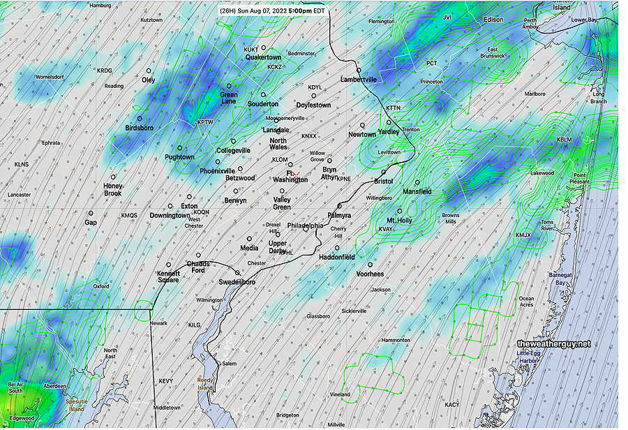
Tonight’s 00z NBM showing light scattered showers at 5 PM Sunday. (Click on image for a larger view.)
Sunday will be mostly sunny, with occasional clouds. While scattered showers are forecast for late afternoon and evening, most areas will remain dry.
High 93ª NBM model Blue Bell PA. Dew point temperatures in the mid to upper 60s- increasingly uncomfortable.
Update Sat 08/06 @ 10:59 AM — This morning’s models keep us dry through the day Saturday. The anticyclonically curved flow causes the air to sink inhibiting storm development.
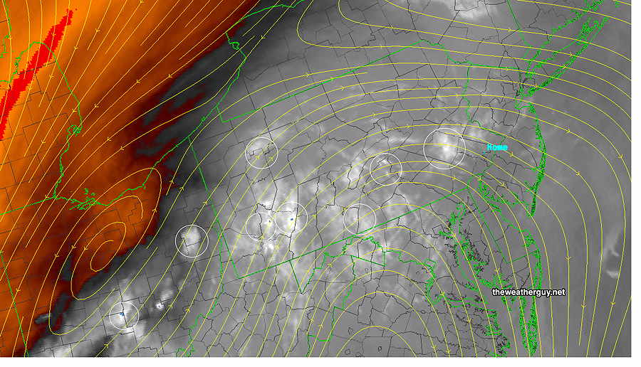
Update Sat 08/06 @ 9:31 AM —This morning’s water vapor image shows the various potential triggers for showers and thunderstorms today—
Water Vapor shows various potential storm triggers (circled in white) today in the jet stream level flow (yellow stream contours) The sharp anticyclonic flow (yellow contours) may inhibit these triggers from storm development. (Click on image for a larger view.)
Showers and storms are possible anytime today, although most of the day will be dry in most places.
Previously Posted Fri 8:36 PM —
A diffuse summertime pattern with the moist flow of a Bermuda high in the Atlantic pushing back on a weak cold front that has been trying to move through Pennsylvania today.
Water Vapor Satellite image showing upper air disturbances (dark blue areas) around Pennsylvania embedded in a moist flow around the Bermuda high. The disturbance to our west, Lancaster/York counties, may yet produce some storms here later this evening. (Click on image for a larger view.)
No specific model has correctly identified the timing and location of the storms the past two days. That likely will be the case over the weekend.
For those hoping for rain, there is the possibility that a disturbance just to our west in Lancaster/York counties may still spark some storms later this evening.
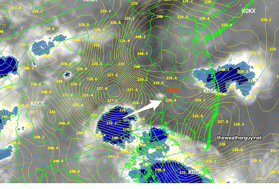
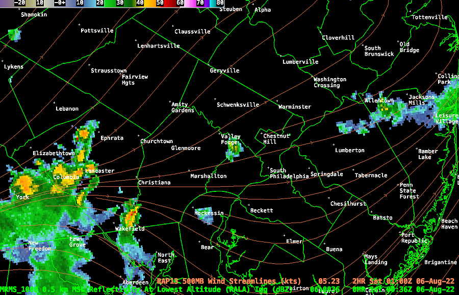
WV showing upper air trigger near Lancaster/York with weak 500 mb flow towards us (arrow) Unfortunately, the yellow contours suggest that the disturbance may not fully make it towards us. (Click on image for a larger view.)MRMS radar with RAP 500 mb wind streamlines. (Click on image for a larger view.)
For Saturday, we remain in the hot moist airflow. Some models are forecasting scattered thunderstorms at any time during the day. The Canadian GEM is is pushing for some storms around noon to 1 PM on Saturday.
The same pattern continues for Sunday. It will be difficult (maybe impossible) to accurately predict timing and location of any showers/storms.
Saturday
A mix of clouds and sunshine. A chance of showers and thunderstorms any time, especially noon/early afternoon according to the Canadian GEM
High temperature 89.4º sd 3.3º NBM model Blue Bell, PA (higher than usual sd- standard deviation- the result of uncertainty in cloud cover and showers)
Sunday
Similar to Saturday. Showers / thunderstorms possible anytime and anywhere.
High temperature 90.6º sd 2.5º NBM model Blue Bell, PA
Updated Sat 11:16 PM — Some models are predicting as much as 0.6”-1.1” of rain Sunday night into Monday morning.
Updated Sat 9:53 PM —A warm front had been expected to move in late Sunday night. Things have speeded up a bit. The latest models show clouds moving in as early as 1-2 PM Sunday and becoming mostly cloudy by late afternoon. Some showers develop early evening.
There’s a chance of some light accumulating rain early Monday morning.
Updated Fri 10:52 PM — Tonight’s early models show the following minor forecast changes— Saturday’s high temperatures will be warmer, just under 90°. Sunday has some significant mid level cloudiness developing during the afternoon with some light scattered showers in the evening south of the city.
Previously Posted Fri 6:01 PM —
A front moves through later tonight. As forecast in my morning update, very little rain is expected tonight in the immediate Philadelphia area; most of the light rain will move off to the northwest, affecting northwest suburbs, while another disturbance brings light rain to NJ. We may get some light showers this evening and again about 3 AM.
Clearing by Saturday as high pressure builds in for the weekend.
Not many chances of rain in the coming week. Very strong upper level high pressure builds in after Wednesday bringing very hot and dry weather for us. We may be seeing 100º temperatures again.
Saturday
Sunny and warm. High 86.6º sd 1.0º NBM model Blue Bell, PA
Sunday
Sunny and warmer. Some increasing cloudiness during the mid to late afternoon as a warm front will be approaching Sunday night. High 87.8º sd 2.8º NBM model Blue Bell, PA
Forecast Review— Temperatures have gone beyond what was forecast by the NBM this morning—
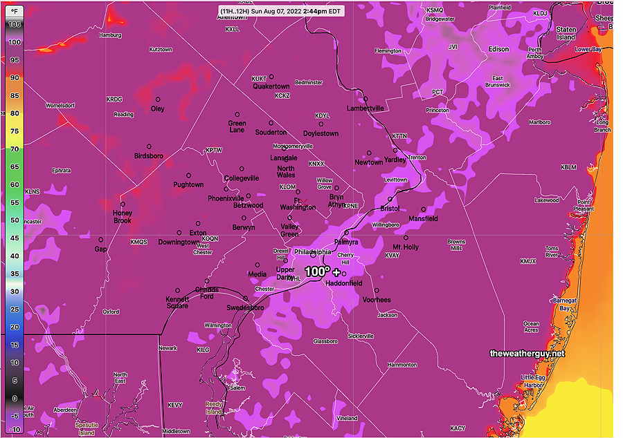
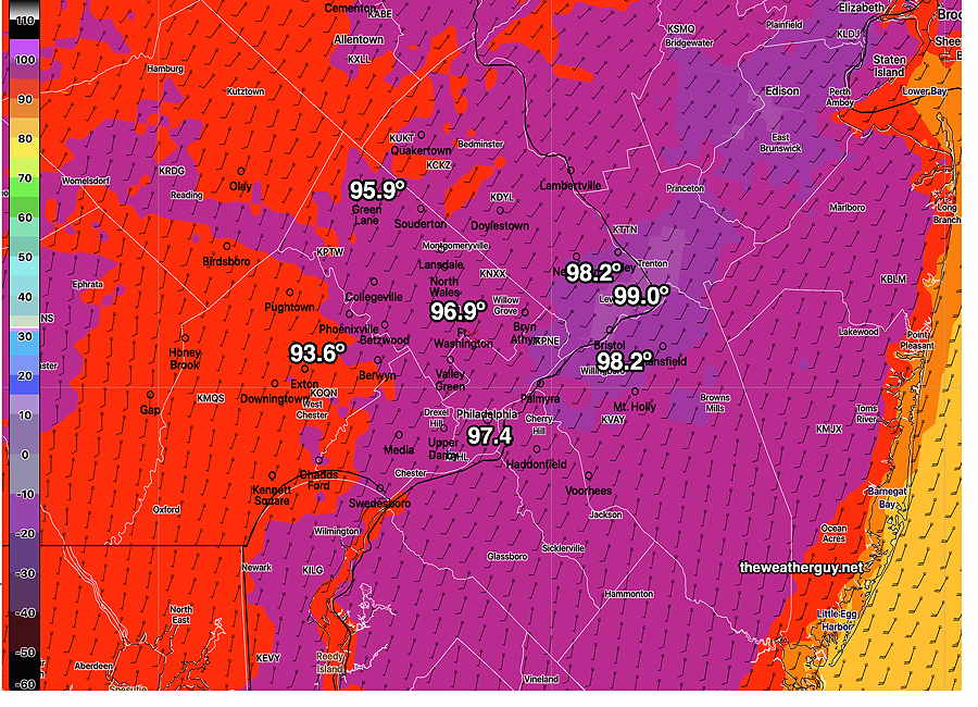
Official temperatures at 4 PM today. Philadelphia International and Northeast Philadelphia airports are at 99º These measurements are reported at certain intervals. If is possible there was a higher temperature recorded between the regular reported intervals. That information will be available later. (Click on image for a larger view.)
Update Sun @ 9:54 AM — New 12z NBM model out continues with the somewhat lower temperatures for Sunday—
Sunday 12z NBM high temp (Click on image for a larger view.)
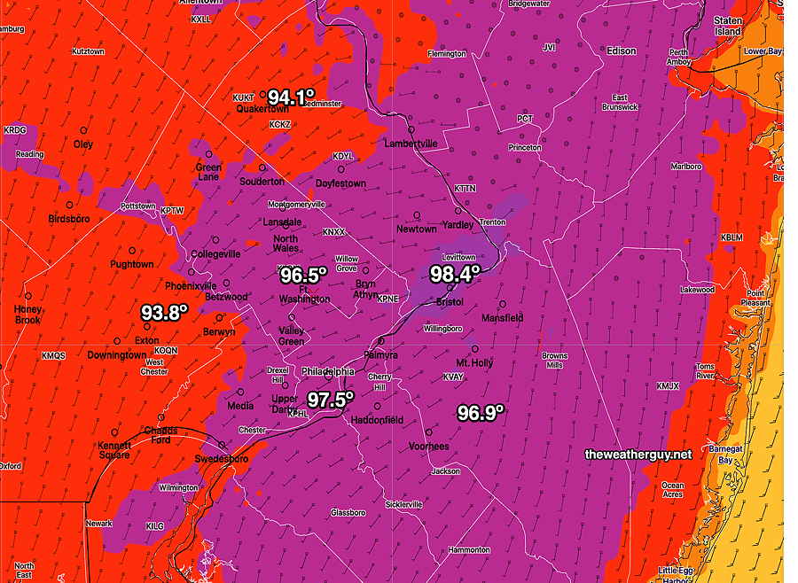
Updated Sun 8:37 AM — Last night’s model blend (NBM) shows high temperatures will not reach the extreme highs forecast yesterday. It appears that highs will be 96-98º with some areas just reaching 99º. Nonetheless, dew points will be higher and heat indexes still forecast to be over 100.
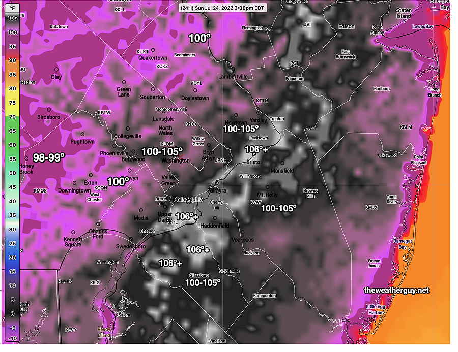
Forecast Review— Actual high temp recorded at Philadelphia Airport on Saturday was 98º and heat index was 100º
Sunday appears to be on track for extremely hot weather. The latest NBM high temperature—
Today’s 19z NBM high temperatures for Sunday (Click on image for a larger view.)
And heat index (apparent temperature)—
Today’s 19z NBM heat index at 3 PM Sunday. (Click on image for a larger view.)
Of interest— some models are showing some widely scattered showers and thunderstorms Sunday evening.
Update Sat @ 10:17 AM — The latest NBM model forecast high temperatures have trended downward slightly for today, Saturday, from previous model runs—
12z NBM mean temperature (Click on image for a larger view.)
Even heat indexes have trended downward for Saturday, as dew points will also be somewhat lower. I don’t see any 100 heat indexes here today .
No change in Sunday’s extreme heat. In fact, the NBM shows higher heat indexes >100 more widespread for Sunday.
Update Fri @ 10:08 PM —Updated the Rain Outlook for Monday
A continued hot and increasingly moist flow of air will be with us for the weekend. Little chance of rain in our area until later on Monday (more about that later.)
Current model jet stream position—
18zSREF showing jet stream position Saturday morning. The jet streak over Wyoming will affect our weather Monday. (Click on image for a larger view.)
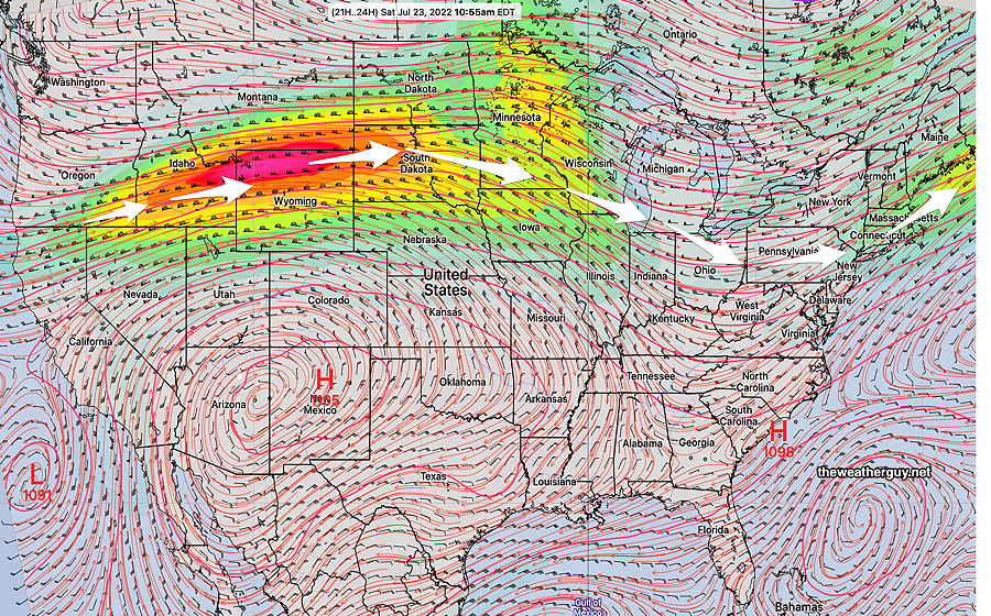
Current water vapor imagery (Friday late afternoon) —
Water vapor image from Friday afternoon provides three dimensional understanding of whats happening now. Stationery front (1) passed through yesterday. High pressure (H) in center of country and hot air conveyor belt (white arrow) will provide heat and humidity for our weekend. The Low system (L) over Idaho will bring a cold front through our area Monday. (Click on image for a larger view.)
Saturday
A southwesterly flow will bring heat and increasing humidity. Sunny and hot.
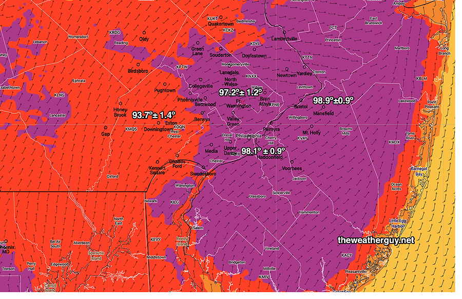
High temperature 97.2º ± 1.2º NBM model Blue Bell, PA
Model Blend (NBM) high temperature forecast for Saturday, shown as statistical mean ± standard deviation. It would not surprise me that the true temperature will be the mean temperature PLUS the standard deviation, meaning some areas will hit 99-100º. This displays actual temperature, not heat index. (Click on image for a larger view.)
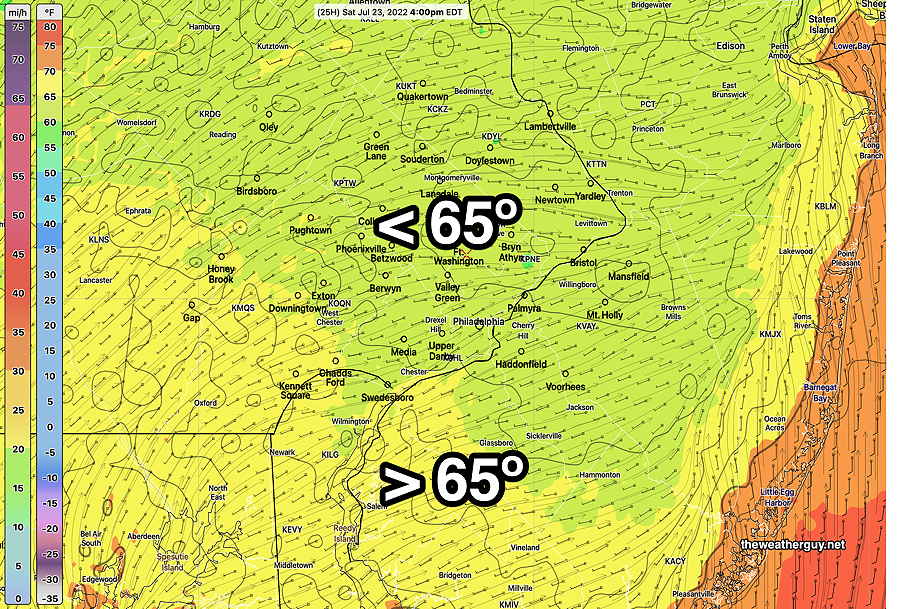
Dew points will be still be moderate, despite the temperatures, although higher than Friday—
NBM Dew points (and winds) Saturday. Contours are 2º dew point temp increments. (Click on image for a larger view.)
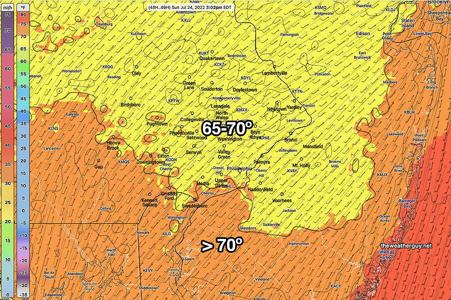
Sunday
Sunday will continue to be extremely hot and increasingly humid. I expect to see actual temperatures reach 100º+ in several areas.
NBM High temp forecast for Sunday It would not surprise me that the true temperature will be the mean temperature PLUS the standard deviation, meaning some areas will hit 100º+.(Click on image for a larger view.)NBM dew points forecast for Sunday in the early afternoon. Much higher than Friday and Saturday.
I’m usually not ‘into’ the heat index (what meteorologists call the “apparent temperature”) since it sensationalizes things and I think is confusing. (If a 100 degree temperature always feels different than 100º, how do you know what a 100 degree temperature really feels like? ….And I hate when TV weather people start talking about temperature and then they talk about heat index and then talk about temperature. Too sensational and too confusing. But don’t get me started. )
Anyhow, the heat index for Sunday is forecast to be impressive. All areas will feel like it’s over 100 (whatever that means. I think it means it will feel unusually hot.)
Heat Index for Sunday—
NBM heat index forecast for Sunday. All areas are over 100. (Click on image for a larger view.)
Just a teaser…we need the rain and the first chance is Monday late afternoon and evening. Will we see this fall apart as it has for several past forecast rains? More about that over the weekend.
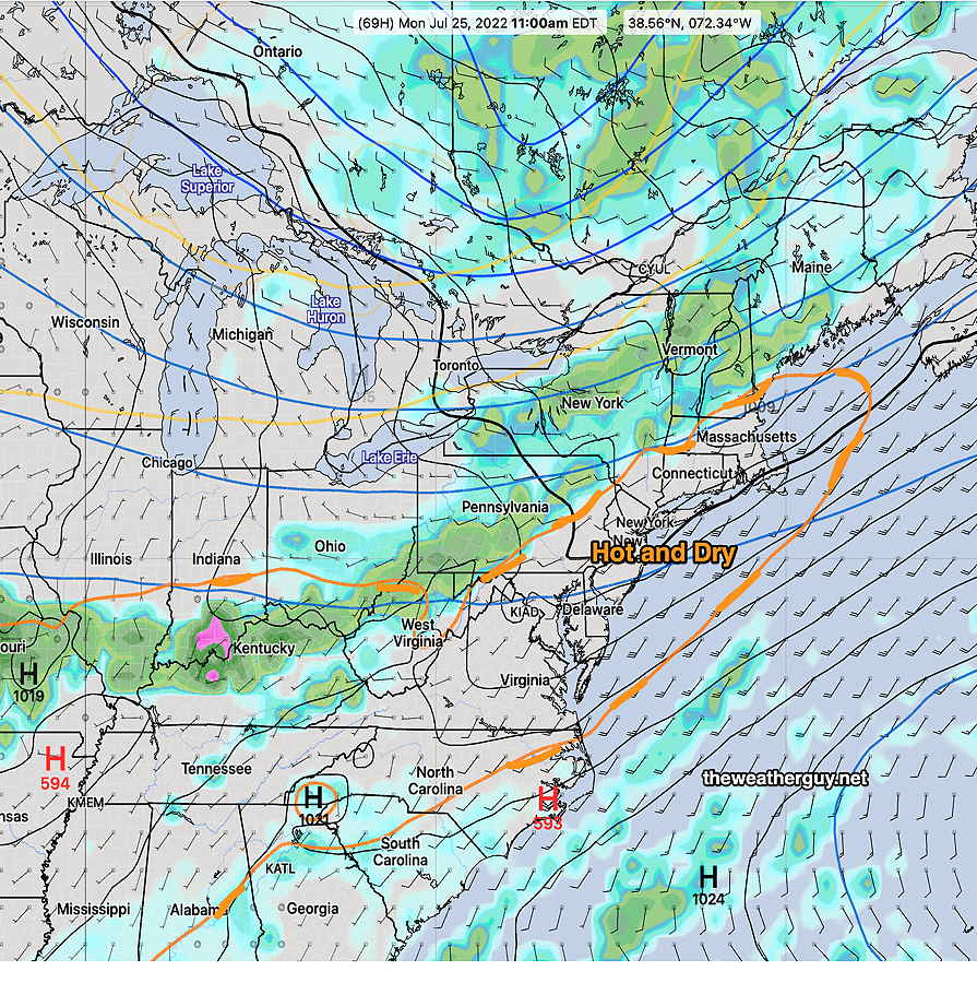
Rain outlook for Monday
Rain Outlook for Monday—
Latest models suggest a repeat of a low rain amount event for Monday evening. As has been the case for weeks now, the front will run into a wedge of very dry, hot stable air. Total rainfall may be less than 0.3- 0.5 inches, much less than we need.
18z ECMWF model forecast for Monday late morning. The front will run into a ‘tongue’ of dry, stable air from the Midwest high that pokes into our region. The wedge of dry air is represented by the 1000-500 mb orange “thickness” line that I have emphasized with with additional orange shading. I am postulating that this is causing our dry conditions, along with very low soil moisture causing a negative feedback effect for thunderstorms. See my other post about this here.
Updated Fri 10:52 PM — Tonight’s NAM shows heavy rain for late Monday ( over 2 inches). I’m not sure I believe it.