Update Sun 09/18 @ 10:30 AM — Today’s high temp 83.5º with an unusually low sd of 0.7º
Outlook
Generally warm weather for the first half of this coming week. A rather potent cold front may move through late Wednesday night with showers and thunderstorms.
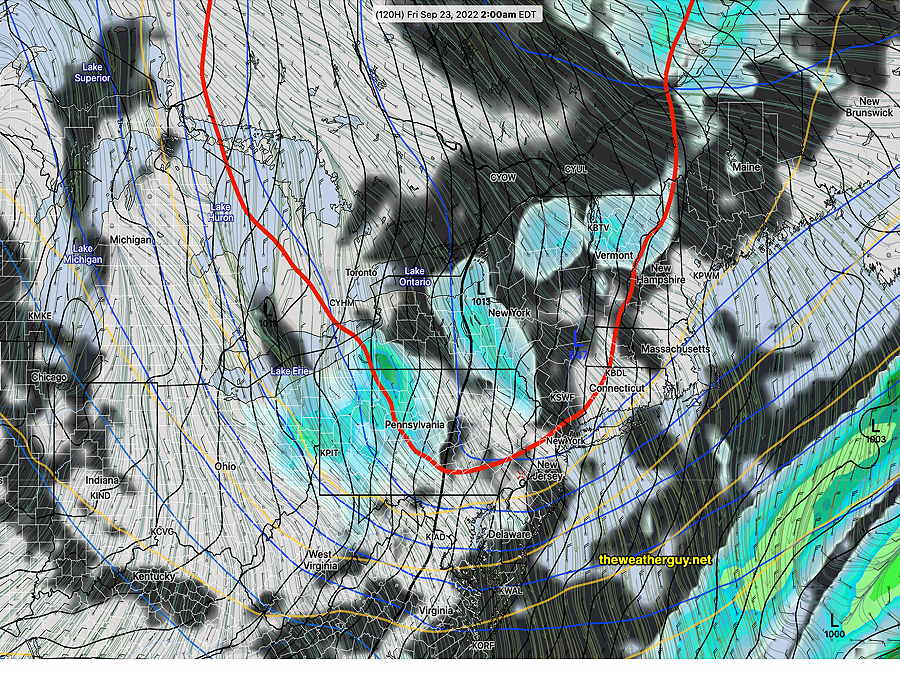
The GFS is advertising a brief, unusually chilly outbreak for late Thursday into Friday. On the weather map, we see the appearance of the 540 thickness line (red), a parameter usually associated with the snow-rain line (in winter).
Today’s 06z GFS forecast for Friday 2 AM with 540 thickness line (red) making an usually early appearance. A brief period of chilly weather next Friday expected. (Click on image for a larger view.)
This dip in the jet flow should assure us that tropical system Fiona stays out to sea.
Updated Fri 9/16 10:01 PM — minor update, highlighted
A fairly straightforward forecast for this weekend as high pressure over us will provide mostly sunny skies for Saturday and Sunday.
Saturday
For Saturday, there will be some considerable high, thin cirrus at times as a result of some moisture streaming over an upper level ridge covering the center of the country. Otherwise, sunny.
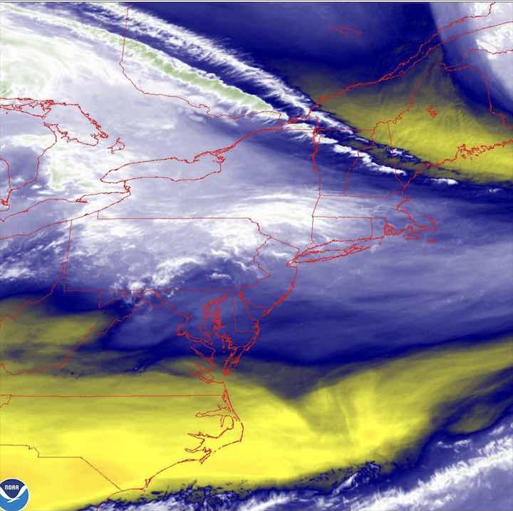
Water vapor showing northern moisture flow
High temperature 82.7º sd 1.2º NBM model Blue Bell, PA
Sunday
Sunny.
High temperature 37.0º sd 1.8º NBM model – for location Blue Bell, PA
Next week shows temperatures trending towards very warm for mid September. A weak front will also move through Monday night. A hurricane developing near Puerto Rico is expected to stay out to sea but it’s not a sure bet, according to the Canadian model. Hurricanes, in general, seem to affect forecast accuracy.
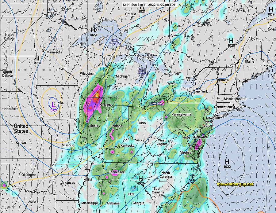
Updated Sat 9/10 10:56 PM — My usual habit of checking current radar and satellite images before a forecast update lapsed tonight. Regardless of the models, current radar shows some showers at our doorstep. So, I guess we know when the rain will start. BTW, only the ECMWF had forecast this early start.
Update Sat 09/10 @ 9:43 PM — There’s still some uncertainty about the start of the rain tomorrow in the immediate PHL area. The trend has been for some showers to move in as early as daybreak or early morning. Periods of rain on and off during the day. Anywhere from 0.5″ to 1.0″ expected tomorrow through Sunday evening. Additional rain expected Monday into Tuesday.
Today’s 18z ECMWF shows the rain well into our area by 11 AM Sunday. Additional rain expected Monday into Tuesday associated with the upper low in Iowa as it move eastward. (Click on image for a larger view.)
Updated Fri 9/09 10:54 PM — Tonight’s models are cranking out some moderate rain for Sunday afternoon and evening.
Updated Fri 9/09 8:23 PM — A continuing change with the onset of showers on Sunday. This afternoon’s Canadian high resolution HRDPS, the German ICON, and the ECMWF models forecast an earlier start— as early as 8 AM Sunday. Our US models are still forecasting the rain to move into the immediate Philadelphia area between 12 and 2 PM.
With the moisture approaching faster, expect some fog early Saturday morning before the sun burns through about 11 AM.
Saturday: fog early, then sunshine by late morning. Clouds move in mid-afternoon on Saturday. (no fog today!)
Sunday: Showers in western suburbs as early as Sunday morning, moving into the city around noontime.
Update Fri 09/09 @ 12:41 PM — This morning’s GFS has moved towards the ECMWF with a faster approach of Sunday’s system.
Saturday: Clouds move in mid-afternoon on Saturday.
Sunday: Showers in western suburbs as early as Sunday morning and moving into the city around noontime. A break in the action mid-afternoon before more showers move in during the evening.
Previously Posted Fri 10:50 AM —
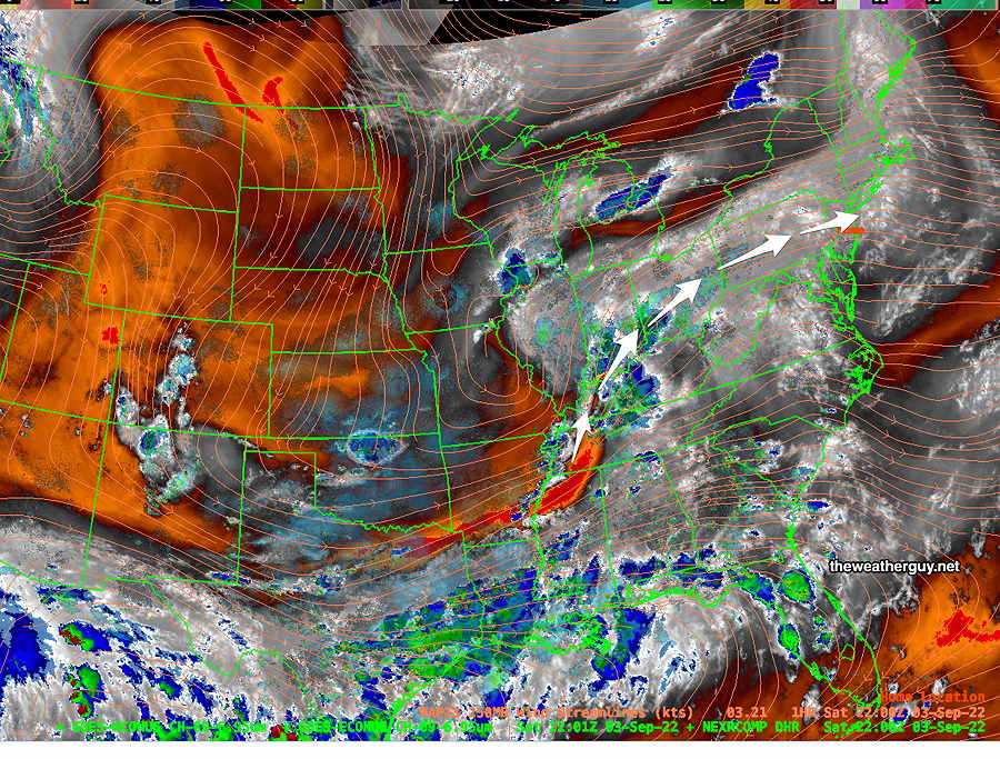
A dry flow over us will keep delightful September weather over our area through Saturday. Extensive dry flow is visible on current satellite water vapor imagery—
Current Water Vapor image Friday morning. Warm dry air flow (orange -red shading) is over us. I’ve drawn a warm front position over the advancing system from the south. This will affect us on Sunday. (Click on image for a larger view.)
High pressure over our area Friday and Saturday will slowly move offshore to our east as the warm front moves up from the south.
By Sunday, the high pressure system will be off the coast, possibly blocking the advance of showers and rain to our south and west until late afternoon or evening—
NAEFS model forecast for Sunday at 11 AM. High pressure is blocking rain moving in from the west. (Click on image for a larger view.)
The uncertainty in this forecast will be the degree of blocking provided by the high off the coastline and the timing of the showers on Sunday afternoon or evening.
The NBM (model blend) maintains the block and keeps the showers in far western areas for much of the afternoon and early evening. Here’s the NBM probability forecast for rain on Sunday at 5 PM—
Today’s 12z NBM precipitation probability forecast for Sunday at 5 PM. (rain becomes a good bet in the green-yellow and certain in the violet areas) (Click on image for a larger view.)
While several models (and model blend) keep the rain to our west for much of the day, the ECMWF has been consistently aggressive in bringing rain in as early as Sunday morning. I’m leaning towards late afternoon at this time.
Saturday
Sunny and pleasant. Some clouds move in during the late afternoon and evening.
High temperature 82.5º sd 2.1º NBM model Blue Bell, PA
Sunday
Cloudy with increasing chance of rain moving in during the mid to late afternoon. (rain significantly earlier western areas)
High temperature 76.7º sd 4.1º NBM model Blue Bell, PA (higher than normal sd – uncertainty)
Some models have a good, soaking rain late Sunday night into Monday with rainfall about 1″
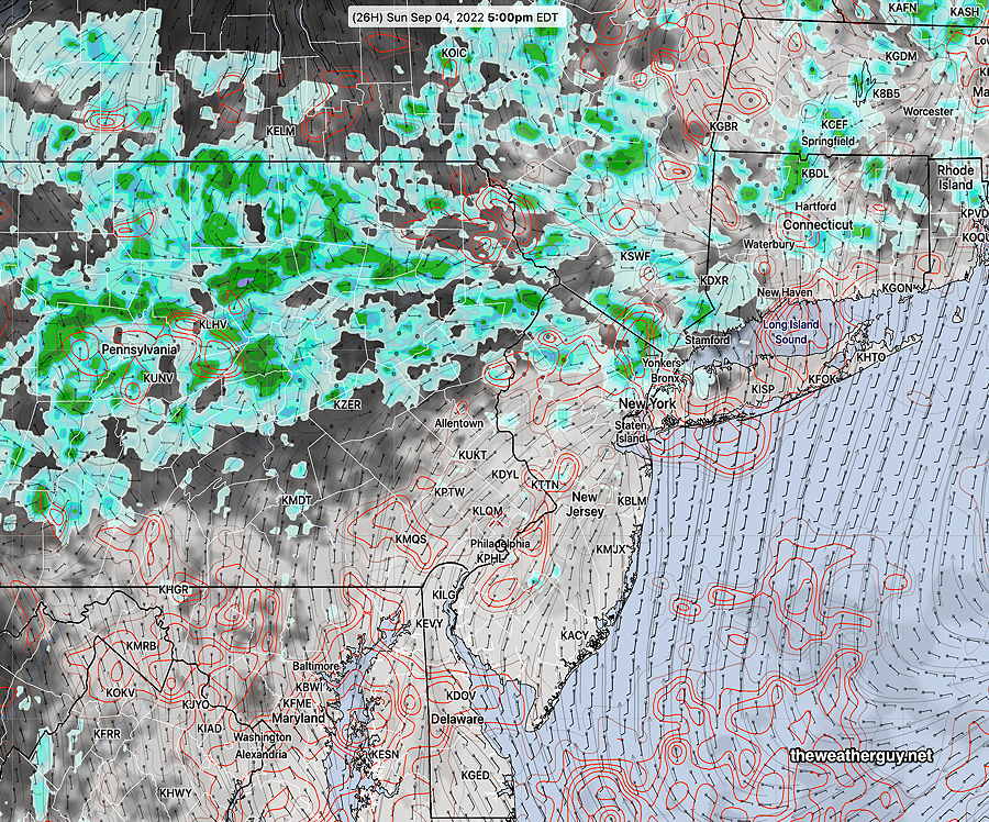
Update Sat 09/03 @ 5:49 PM — The forecast posted Friday still looks good. It does appear that we’re going to luck out: no rain in the immediate PHL area (and the shore) until late afternoon on Monday.
Current weather at 6 PM—
Water Vapor with jet stream level wind streamlines (orange streamlines) with superimposed radar. Moisture and rain flow will move north of our area through Monday. (Click on image for a larger view.)
Sunday afternoon has the showers circling up around the region. We stay mostly sunny through high clouds and dry—
NBM forecast for Sunday 5 PM. Cloud cover is in grey/black. Red contours are spread uncertainty in cloud cover. Rain is green. (Click on image for a larger view.)
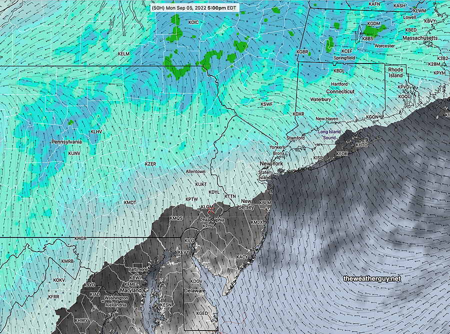
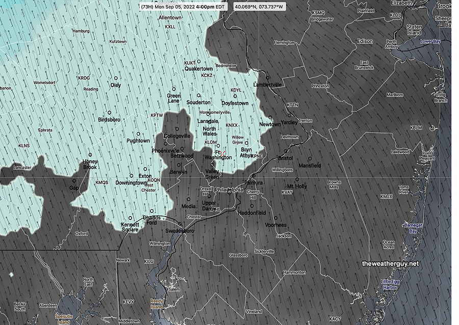
For Monday, the rain gradually moves in from the north and west. We’ll have significant cloudiness ,thickening during the afternoon, with rain by 5 PM, according to the latest NBM—
NBM forecast for Monday 5 PM rain moves down from the northwest. (Click on image for a larger view.)
Hard to believe, but the NBM cranks out a widespread rainfall of about 1 inch through Tuesday.
Updated Fri09/02 @ 11:35 PM — The forecast below remains on target.
Updated Fri 09/02 @ 5:45 PM —Not much change in the forecast (see the earlier “outlook” below). The system moving towards us may be even slower to arrive, which means Saturday and Sunday will be dry.
Indeed, the areas from just west of Philadelphia and eastward which have seen the least rainfall in recent months, will continue to be bypassed by any showers.
Saturday
High thin clouds much of the day; occasional periods of more signficant cloudiness. Dry. (There may be some afternoon showers along the NJ, coast according to the latest NAM-NEST.)
High temperature 86.4º (sd 1.3º) NBM model Blue Bell, PA
Sunday
Cloudy early morning, then sunshine by noontime. Increasing cloudiness again later in the afternoon and towards evening. Dry.
High temperature 87.9º (sd 3.2º) NBM model Blue Bell, PA
Monday
Considerably more cloudiness. Some models keep us dry while others have light rain moving in late afternoon or evening. (There’s significant uncertainty with Monday’s forecast.)
NBM Forecast Monday 4 PM. Light showers northwest, cloudy elsewhere. (Click on image for a larger view.)
High temperature 83.2º (sd 3.1º) NBM model Blue Bell, PA
Early Labor Day Weekend Outlook
Previously Posted Fri 10:13 AM —
A weak jet flow will result in slow movement of weather systems into our area.
A somewhat stationary area of moisture in the Mississippi valley will slowly approach over the weekend. Here’s what it looks like Friday morning on satellite water vapor imagery—
Current water vapor image (Friday morning) with stalled stationary front This area of moisture will very slowly move eastward bringing an increasing chance of showers late Sunday and Monday. (Click on image for a larger view.)
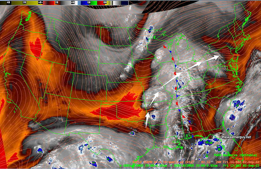
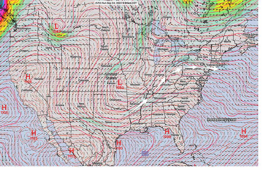
The current upper air (jet stream level) map shows a somewhat stationary area of low pressure that will linger out west due to weak jet winds—
ECMWF jet stream level wind forecast for Sunday at 5 AM. Low pressure in the middle of the country with upper winds bringing moisture up from the Gulf of Mexico. (Click on image for a larger view.)
With systems moving so slowly (note the colored, higher speed winds can only be seen in the northwest corner and northeast corners of the map) the upper level low pressure system in Kansas will linger as moisture streams up over our area.
Based on the GFS and ECMWF, we’ll have mostly high cloudiness on Saturday and Sunday. Timing any showers precisely will be difficult. With continuing drought conditions, I expect any showers to stay mostly west of Philadelphia through most of Sunday.
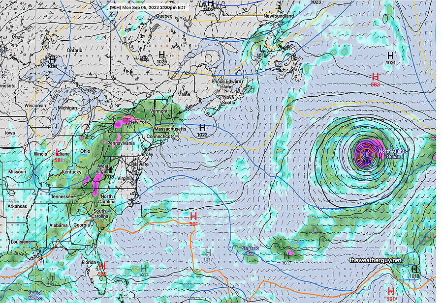
There’s a hurricane in the North Atlantic. From experience, tropical systems with weak steering currents play havoc with forecasts even if they are many hundreds of miles away. I expect forecasts to change over the next few days, likely leaning towards even better weather.
According to the ECMWF, even Monday will be mostly rain-free—
ECMWF forecast for 2 PM Monday. Tropical system in North Atlantic. Rain hangs back into western Pennsylvania. (Click on image for a larger view.)
Updates later today and during the weekend. Stay tuned.