Category Archives: Philadelphia Area Weather Forecasts

WEEKEND WEATHER FORECAST

theweatherguy and Twitter – Life after Twitter?
Click here.

Colder Sunday

Update Sat 11/12 @ 6:13 PM

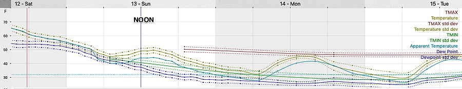
A cold front moves through after midnight tonight (Saturday) with showers. Colder air moves in Sunday and especially Sunday night. A mix of clouds and sun with highs 50.8º sd 1.8º NBM model, Blue Bell. (Average high this week is 54º-55º)

NBM temperature meteogram for Blue Bell, PA (Click on image for a larger view.)

The long term outlook is for temperatures to be at or below normal for the next 10 days or so.

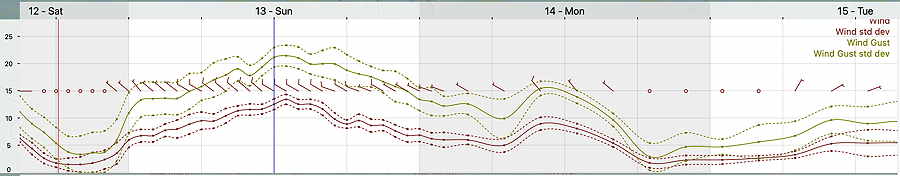
It will be fairly windy and gusty—

NBM winds and wind gusts for Blue Bell PA (Click on image for a larger view.)

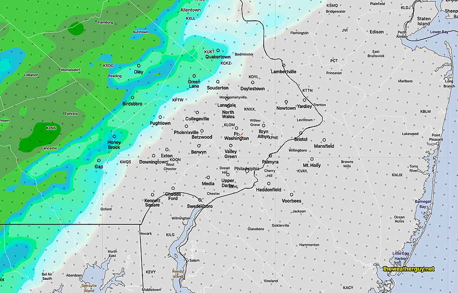
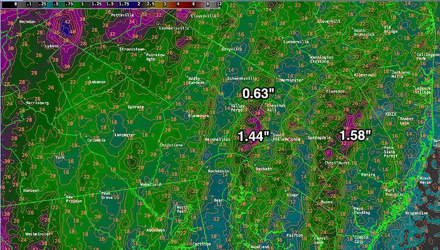
BTW, how much rain did we get on Friday? Not as much as it seemed—

MRMS rainfall estimates for Friday. Contours are in mm (25.4 mm = 1 inch) (Click on image for a larger view.)

Where’s the Sun?

Update Sat 11/12 @ 5:26 PM

Well, my ‘experiment’ with relative humidity didn’t work. The models were correct and we had mostly sunny skies. I do realize what I had overlooked— there was too little moisture at upper levels. Anyhow, I always like to see what parameters connect with sensible weather and this is what makes it fun for me.

We might have a chance to try the same technique tomorrow. 🙂
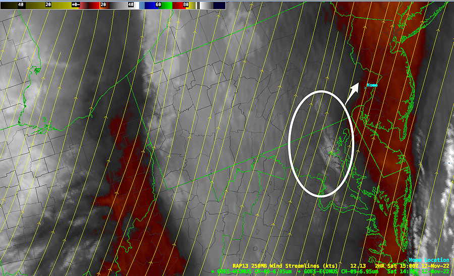
Update Sat 11/12 @ 9:31 AM
I was curious about the amount of sunshine today. For a reason. The models’ cloud algorithms are still pushing clouds to dissipate with sunshine, but a look outside suggests otherwise.

The latest GFS and HRRR all show little to no cloudiness at this hour. Not correct and not the first time their cloud algorithms under-forecast cloudiness.

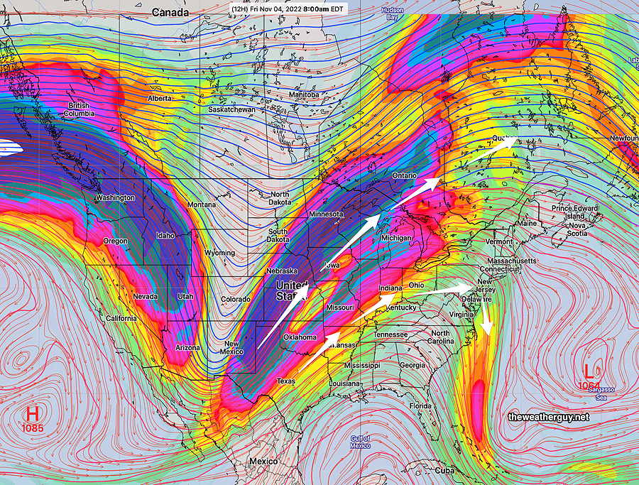
What the models all show is significant moisture at about 3000 feet (925 mb height). Here’s the GFS current model—

GFS 925 mb Relative Humidity and 500 mb Vorticity (contours) for noon today. Significant low level moisture with vorticity providing upward motion may keep the clouds in place longer. (Click on image for a larger view.)

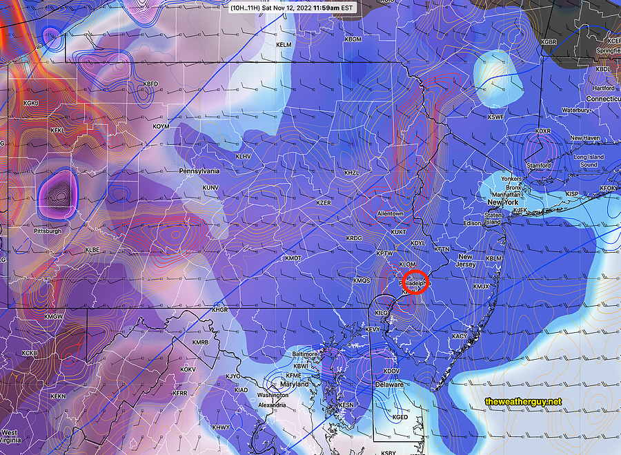
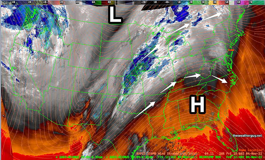
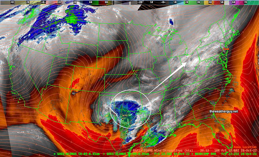
Water Vapor shows upper air disturbance (vorticity)—

As is often the case, the latest Water Vapor satellite image shows the area of vorticity. This is expected to move in around noon, according to the GFS and move out about 2-3 PM. (Click on image for a larger view.)

So if we use the model’s cloud algorithms, we have sunshine shortly. If we use ‘my technique’ of relative humidity at specific levels combined with voriticity, we have clouds lasting until about 2 PM or so. ‘My technique’ has let me down in the past, so it’s an interesting experiment.


Updated Fri 11/11 9:41 PM —
Tonight’s models are pushing more sun, little cloudiness on Saturday.

Previously Posted Fri 6:21 PM —

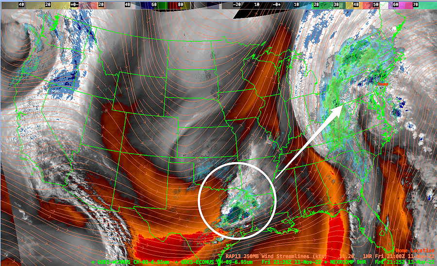
The remnants of what was Nicole will depart around daybreak Saturday and we will likely wake up to a mix of clouds and sunshine.

We can see the remnants of Nicole plainly visible on the current water vapor satellite image, but also note a developing disturbance (white circle) that will affect our weather Saturday night—

Water Vapor image showing the remnants of Nicole. A disturbance has developed at the base of the jet trough (white circle) and this may move in to our area late Saturday night (GFS model) or early Sunday morning (ECMWF model) It will be fast moving, as it’s embedded in a very strong jet streak.

Saturday

A mix of sun and clouds in the morning, but there may be periods of considerable cloudiness later in the afternoon as a secondary cold front and the disturbance approaches. It will be mild in the morning (upper 60s), but temperatures will be dropping slowly to near 60 after 2 PM. Windy in the morning, but winds should slowly decrease during the day.

High temperature 68.1º sd 1.1º NBM model Blue Bell, PA (this high will be in the morning.)

Some showers moving in late evening.

Sunday

Showers should depart early morning. A period of sun in the morning will give way to instability cloudiness in the early afternoon. The sun may break out again late afternoon. Winds breezy and somewhat gusty.

High temperature 50.6º sd 1.8º NBM model Blue Bell, PA

Areas of temps at or below freezing Sunday night in areas north and west of the city.

WEEKEND WEATHER FORECAST

Poor Forecast—

Forecast Review Sun 11/06 @ 12:06 PM — “I thought the rain would stay to our west?”

Folks, I was off-duty most of Saturday 😉 and I thought I could coast on what seemed to be a high confidence forecast with any rain staying to our west. BUT not so!

When it started raining about 10 AM this morning, I went back to look at last night’s models and, as suspected, none (except for the ECMWF and Canadian HRDPS) showed any rain for the immediate PHL area for this morning.

Since the ECMWF has shown a tendency to over-predict precipitation over recent months, had I actually looked last night at updating the forecast, I probably would have ignored it.

Even the new GFS v 16.3 didn’t show rain here this morning. Numeric Weather Prediction (” the models”) often amazes me. Not today.

Update Sun 11/06 @ 9:23 AM — Periods of clouds and periods of sun throughout today. Radar is showing some showers moving in from the south, somewhat further east than had been forecast yesterday. Some parts of the city may has a few showers. The models have been consistent with the most cloudiness between noon and 3 PM. High temperatures 75º ± 1.5º. Breezy and gusty winds to 25 mph.

Enjoy the mild weather. A change coming Friday with a tropical-sourced coastal system followed by a stronger cold front.


Update Sat 11/05 @ 8:57 AM — We had less fog than forecast this morning and that will likely be true again on Sunday.

The models are in agreement with front barely making it through Philadelphia on Sunday.

HREF model forecast – the expected maximum eastward extent of any showers with the front on Sunday. (Click on image for a larger view.)

There’s a range of uncertainty with the amount of cloud cover for Sunday, with the NAM-NEST showing considerable cloudiness for much of the day and the GFS having considerable breaks of sun except for a period of thicker clouds in the early afternoon.

Uncertainty in the cloudiness will affect the high temperature forecast. Either way, expect temps in the 70s.


Update Fri 11/04 @ 5:51 PM — Updated forecast below to include wind gusts both Saturday and Sunday and early morning fog Saturday. Also light scattered showers Sunday morning, based on latest HRRR model.

Unseasonably Warm Saturday & Sunday

A warm southwesterly upper air flow will bring unseasonably mild air to us Saturday and Sunday.

Current water vapor image (Friday) shows strong upper ridge over the eastern US and a sharp trough in the mountain region of the west. A front in the central part of the country will lift north and west of us.

Friday morning Satellite Water Vapor Image (with RAP jet stream streamlines overlay) shows upper ridge and upper trough east of the Rockies. A cold front with showers over Missouri that will lift north into Canada. Warm flow for us from the southwest. (Click on image for a larger view.)

The ECMWF model forecast for the above water vapor image—

Friday’s 00z ECMWF shows the same jet stream config as above water vapor image. (Click on image for a larger view.)

The deep trough in the Rockies will flatten as the amount of cold air is limited by this push. By Sunday, things look very different but we’ll still be in a southwesterly flow —

ECMWF jet stream wind forecast for Sunday evening. Strong flat flow. Little support for cold front. (Click on image for a larger view.)

With the upper air trough dissipating, there won’t be much support for the cold front when it moves through our area early Sunday afternoon.

Update: High resolution models show some light showers making it into the immediate PHL area Sunday morning.

The GFS just shows a brief period of clouds moving through Sunday afternoon —

Friday’s 06z GFS forecast for Sunday at 1 PM. Some rain in western and central PA with the remnants of the cold front. Only some mid=level clouds (brown and tan) will in our area early afternoon. (Click on image for a larger view.)

Saturday

Considerable fog early morning, then sunshine through high thin cloudiness. Somewhat gusty winds from the south about 20 mph.

High temperature 74.5º sd 2.8º NBM model Blue Bell, PA

NBM forecast high temperatures Saturday. (Click on image for a larger view.)

Sunday

Areas of fog early (less than Saturday), then brightening skies. A few widely scattered light showers in the morning. A period of mid-level clouds in the afternoon with the remnants of the cold front. Fairly windy with wind gusts from the South Southwest over 30 mph.

High temperature 75.5º sd 1.8º NBM model Blue Bell, PA

WEEKEND WEATHER OUTLOOK

Update Sun 10/30 @ 8:19 PM — I guess I need to say that my previous forecast update below is tilted perhaps towards too much optimism. Here’s the latest Canadian High Resolution model—

Today’s 18z HRDPS forecast for 9 PM Monday night. (accumulated rain) (Click on image for a larger view.)

Update Sun 10/30 @ 8:04 PM — This afternoon’s models have clustered towards the following forecast for Monday evening— with the exception of the ECMWF, rain won’t arrive in Philadelphia until after 10 PM. Some suburbs to our west may see some very light showers as early as 7-8 PM. If the GFS is correct, some light rain moves into Philadelphia just as the Phillies are wrapping up (well, maybe the 7th inning) for a game 3 win. Somewhat heavier rain moves in later Monday night into Tuesday morning.

Comparing GFS 16.2 and new GFS 16.3 (today’s 18z model run)

GFS version 16.2—

GFS 16.2 forecast for 10 PM accumulated rain. (Click on image for a larger view.)

New GFS v 16.3—

GFS (newest version) 16.3 forecast 10 PM Monday night. (accumulated rain and clouds (black) ) (Click on image for a larger view.)

Update Sun 10/30 @ 9:27 AM — Another beautiful day expected for today, Sunday. But there’s a lingering question about the chances for rain Monday evening for the Trick-or-Treaters and the Phillies World Series Game.

The ECMWF has consistently shown rain between 7 and 11 PM for Monday evening. This forecast is supported, in part, by the Canadian High Resolution model and the German ICON model.

The ECMWF 3 hour accumulated rain forecast for Monday evening—

Today’s 00z ECMWF forecast for Monday evening at 8 PM. (3 hour accumulated rain) (Click on image for a larger view.)

The US models have consistently shown rain moving in later, about 10-11 PM.

Here’s the latest GFS (new version 16.3)—

Today’s 06z GFS forecast for 10 PM Monday. (3 hour accumulated rain) (Click on image for a larger view.)

Unfortunately, I am now leaning towards some light rain during the Phillies game, possibly about 9-10PM. Rainfall may be as little as 0.03″ but the ECMWF shows 0.20″- 0.40″.


Updated Fri 10/28 10:27 PM — Saturday- Sunny. High 60°
Sunday mostly sunny. Some clouds may move in during Sunday afternoon in our southern and western suburbs. High 62°.

Most models have Halloween mostly dry. The exception is the ECMWF which has significant showers during the evening.

Previously Posted Fri 9:51 AM —

High pressure will slowly move off to the northeast while a storm shears off to our wesst late Sunday into Monday. (The storm brewing near Texas could be the Phillies?!)

Mostly sunny skies expected for Saturday and some clouds and sun are forecast for Sunday.

Current Water Vapor (jet stream level) —

WV Satellite image captures upper atmosphere. (Water vapor imagery is NOT clouds. It shows temperature, moisture height and motion.) Low pressure is expected to shear off to our northwest late in the weekend. (Click on image for a larger view.)

Here’s the new GFS (v. 16.3) model forecast for Friday afternoon at 2 PM. It shows some mid-level cloudiness moving in from the west—

GFS v 16.3 forecast for today, Friday at 2 PM. (Click on image for a larger view.)

Let’s see how the new GFS does with the today’s cloud forecast.

Halloween evening is looking much better than it had previously.