Category Archives: Philadelphia Area Weather Forecasts

THIS WEEK’S WEATHER

Friday

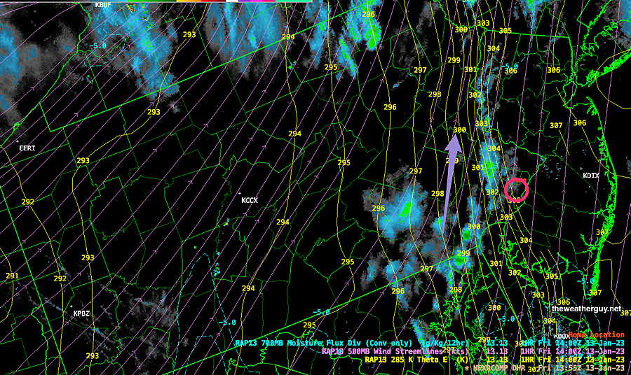
Update Fri 01/13 @ 9:34 AM — The rain has lingered longer than I had forecast. (The latest NBM and HRRR show no showers here at this time. Go figure.) The residual showers should be tapering off and moving off shortly to our northwest by about 11:30 AM

Latest Radar with superimposed Theta-E (yellow contours) and 500 mb wind streamlines (violet) . The tight packing of the Theta-E contours just west of the city shows the position of the front. (RAP model) (Click on image for a larger view.)

Friday and the Weekend

Update Thu 01/12 @ 5:19 PM — The showers and rain have moved in with a warm front, and additional rain will precede a cold front passage early on Friday morning.

The rain ends about 7-8 AM Friday morning.

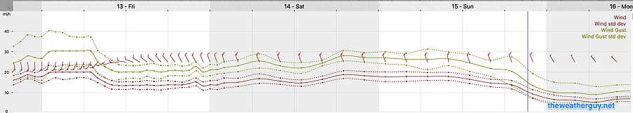
The models aren’t predicting all that much rain (0.30-0.40 inches) in our area. The big story will be the WIND which is already picking up as I write this.

Gusts 30 to possibly 40 mph towards midnight tonight and windy conditions through the weekend. Here’s the NBM wind meteogram for Blue Bell—

Latest NBM forecast wind and wind gusts for location Blue Bell PA. (Click on image for a larger view.)

Temperatures will drop from the 50s Friday morning to the mid 40s in the afternoon, but the wind chill will make it feel colder. A mix of considerable cloudiness with some sun expected on Friday,

A secondary cold front moves through Friday evening and temperatures will drop below freezing by early Saturday morning. The weekend will be sunny, cold and dry.

One more thing — considerably colder air is finally pooling in Canada and in Greenland. In another 7-10 days, we will likely see some snowstorm activity as the cold air sinks south. (Just conjecture at this time. )

Thursday Through Friday

Update Wed 01/11 @ 5:10 PM — Moisture aloft moving in from the southwest over colder air at the surface will result in light showers or drizzle early Thursday morning. The rest of the day looks to be cloudy with additional showers later in the afternoon.

Thursday night: Rain develops during the evening hours Thursday and becomes heavier around midnight. Look for WINDY conditions to develop as the evening progresses. Thursday into Friday as a warm front approaches.

Friday: The warm front moves through before daybreak and then a cold front moves through Friday morning. Skies begin to clear late morning on Friday. It will be windy and temperatures will slowly drop. Friday will still be relatively mild.

A stronger cold front moves through early Friday evening.

Much colder for the weekend!

ECMWF forecast for Friday at 10 AM. Rain is ending here around that time. A sharp but progressive dip in the jet stream (as captured by the red 540 thickness line) will bring cold air on Saturday and Sunday. (Click on image for a larger view.)


Wednesday

Update Tue 01/10 @ 8:15 PM — Not much happening weather-wise, so let’s see if tomorrow’s cloud forecast does better. Thickening high cirrus clouds in the morning. Cloudiness increases about 10:30 to noon. Cloudy most of the afternoon. (Based on tonight’s 00z NBM and HRRR, just available.) Easterly winds will keep it colder to about 43º for a high.


Tue 5:36 PM Forecast Review — We had less cloudiness than any of the model forecasts had predicted. Cloud forecasts can be challenging.

Forecast Update

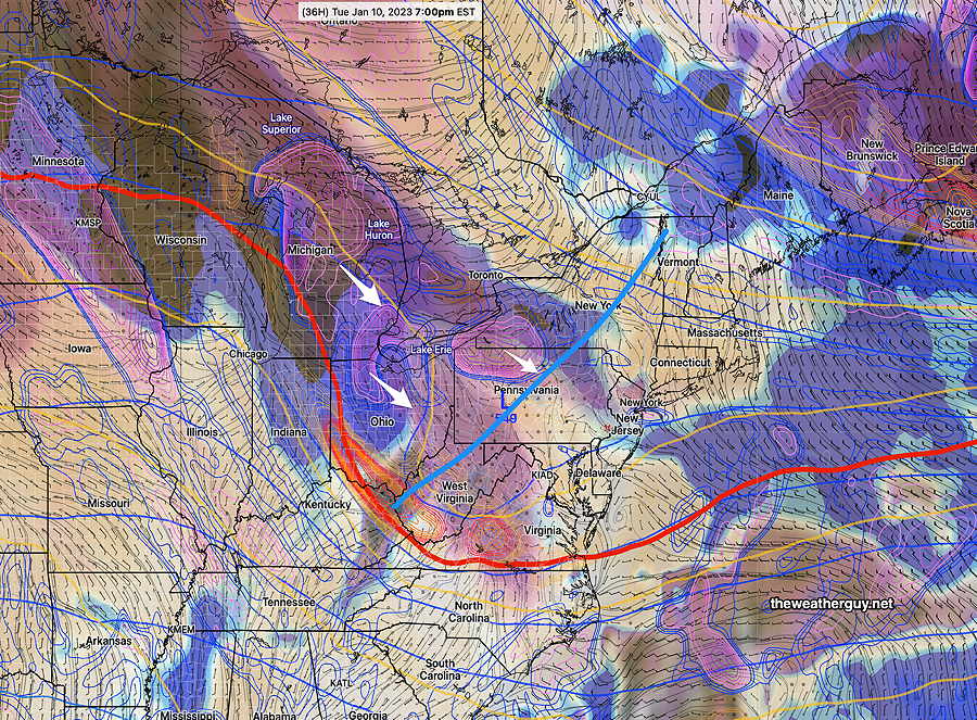
Update Tue 01/10 @ 9:25 AM — The cloudiness forecast below for today, Tuesday, has begun moving in. These clouds are the result of an upper air disturbance and trough moving through. High 42-44º

For Wednesday, a similar forecast with partly cloudy conditions giving way to mostly cloudy in the afternoon. High 43-45º

The storm for late Thursday into early Friday will be a rain event. Cold air arrives after the storm has departed. High ~55º

The weekend looks cold, but a moderating trend is expected next week with temperatures again above average. I don’t see any potential snowfall for us in the next week or so.

Previously Posted Mon 4:38 PM —

Overview

A benign weather pattern for us this week through early Thursday as a somewhat flat to ridge-like pattern will prevent any storms from forming.

Monday’s 12z ECMWF jet stream wind forecast for Wednesday at 4PM. Low pressure (L) at the surface and aloft is the remnants of the storm that is battering California on Monday. This low will move eastward as high pressure dips down from Canada. (Click on image for a larger view.)

Temperatures warm up a bit on Wednesday and especially on Thursday with the ridge moving eastward.

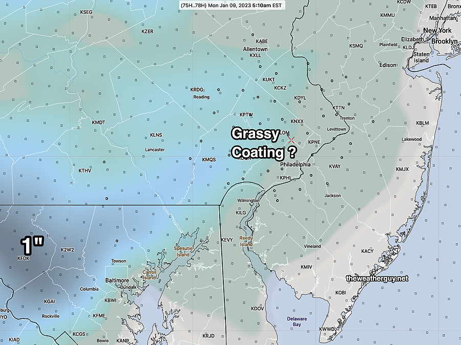
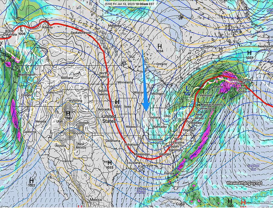
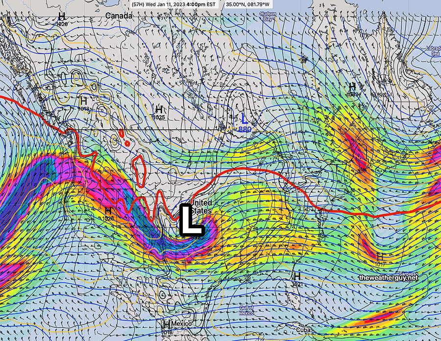
By late Thursday into Friday, a sharp upper air trough will develop and spawn a surface low off the coast—

Monday’s ECMWF jet stream wind forecast (300 mb level winds) for Friday at 4 PM Upper low (L) and deep trough will spawn a surface low (blue small L) off the coast. (Click on image for a larger view.)

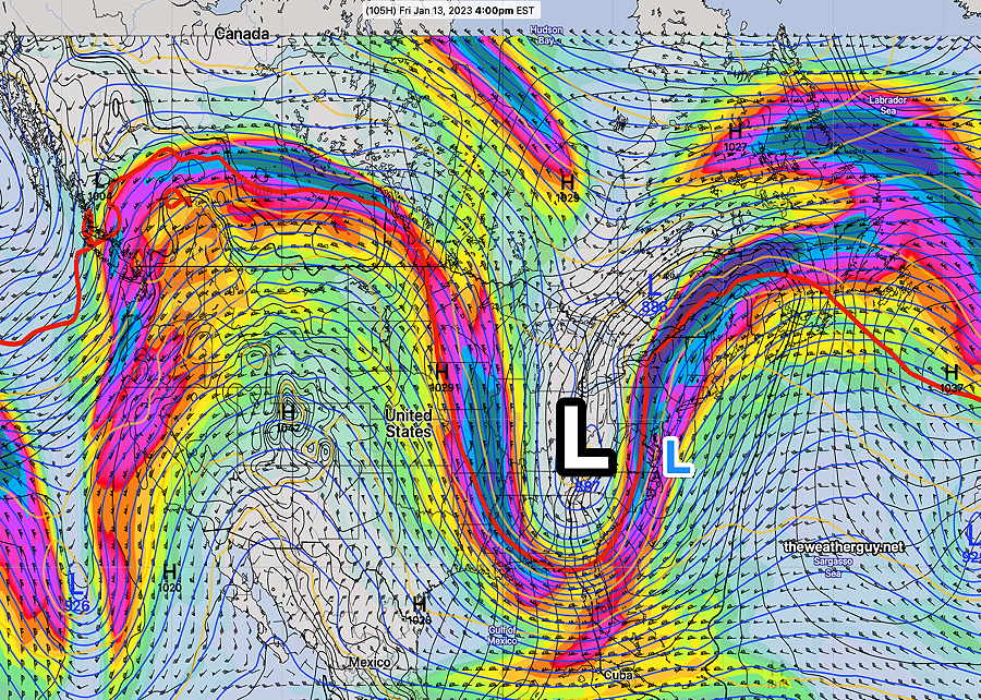
Currently there isn’t much cold air that will move in before the storm departs late Friday afternoon, so all the precipitation will be rain for us late Thursday into Friday. While this could change, there hasn’t been any model suggestion of early deepening of the coastal low.

Tuesday

For Tuesday, an upper level trough with some disturbances will approach with partly cloudy skies becoming cloudy during the afternoon. No precip expected.

ECMWF 500 mb mid level contours with relative vorticity and humidity (Click on image for a larger view.)

By Wednesday, temperatures begin to moderate a bit.


WEEKEND WEATHER FORECAST

Update Sun 1/08 9:58 PM — Tonight’s models. No change. No accumulating snow for the Philadelphia area.


Trending Warmer

Update Sun 01/08 @ 3:43 PM — This morning’s model’s trends show only a coating at most north of Quakertown. (The only exception is the Canadian GEM model.)

The NBM and HRRR show virtually no snow accumulation in our area, although a mix may fall in northwest suburbs.

NBM Precipitation Type probability at 5 AM Monday (Click on image for a larger view.)

Precipitation ends between 7 and 9 AM.


Snow Update

Update Sun 01/08 @ 9:06 AM — Not much change in the snow forecast. The latest GFS and NAM are remarkably similar with snow only accumulating northwest of Quakertown to less than 1 inch.

This morning’s 12z HRRR captures the general picture of most of the models—

Sunday’s 12z HRRR just available shows no accumulation in the immediate Philadelphia area and possible less than an inch north and west of Quakertown.

The latest NBM is even less enthusiastic about accumulating snow in the areas above with its totals 0 – 0.3 inches in the same areas above.


Trending Warmer

Update Sat 01/07 @ 10:48 PM — This evening’s models have trended warmer, in an already marginally cold event for snow.

The latest NAM captures several other models in now predicting little or no snow in Philadelphia and its immediate suburbs to the north and west Sunday night.

Tonight’s 00z NAM shows 32º contour (blue) at 925mb and 32º contour at the surface. Areas shaded in blue may have a light coating on grassy surfaces by Monday daybreak. Most areas in green will not. (Click on image for a larger view.)

Update Sat 01/07 @ 6:15 PM — The latest ECMWF along with the earlier CMC-GEM and NAM show an increasing possibility of a small snowfall on mostly grassy surfaces after midnight Sunday into predawn Monday.

Ordinarily this would a be a clear-cut small snowfall of about 1-2 inches— all upper air temperatures support snow. However, the models are all consistently forecasting surface temperatures to be above freezing (33º-34º)

So while, it’s fairly certain that the precipitation will fall as snow north of Philadelphia, it’s more uncertain how much, if any, will accumulate.

I’ll try to clarify in future updates.

Update Sat 01/07 @ 11:01 AM

Saturday: The cloudiness forecast for today has moved in from the northwest. This morning’s models (with the exception of the NAM-NEST) continues to forecast considerable cloudiness for much of the afternoon hours.

Sunday: Here are the current trends for the precipitation late Sunday—

  • Precipitation moves in later, now closer to and after midnight into the predawn morning hours Monday.
  • Temperatures aloft support snow but temperatures in the lower levels (1000mb-850 mb or near ground level to 4500 feet) are just a bit too warm in the immediate PHL area.
  • Somewhat more coastal development is forecast and somewhat more precip.
  • The latest GFS (12z) and the CMC-GEM (12z) have very different forecasts with the GEM having a narrow band 1-2″ of snow just northwest of the city while the GFS has zero to a coating. The GEM is currently the outlier in this morning’s models.

Previously Posted Fri 4:39 PM —

Colder surface high pressure will build in for Saturday and we’ll be under an upper air cyclonic flow.

Low pressure developing in the Midwest will move in later Sunday and Sunday night.

Friday’s 12z GFS forecast for 1 PM Saturday. High pressure and upper trough (1) will be in control Saturday while a developing low pressure (2) begins to move in from the Midwest giving us light snow Sunday evening. (Click on image for a larger view.)

Saturday

Partly sunny in the morning, but considerable cloudiness moves in from the northwest early afternoon, then more sunshine late afternoon.

High temperature 43.8º sd 0.6º NBM model – for location Blue Bell, PA

Sunday

Sunny in the morning, increasingly cloudiness during the early afternoon. Mostly cloudy by 3 PM. Light snow develops during the evening hours. Temperatures are expected to be just above freezing in and around the city. Accumulations are currently expected to be zero to a very light coating on grassy surfaces near the city, but 1/2 inch far northwestern suburbs (near Allentown). Temperatures are expected to rise slightly at night.

High temperature 41.3º sd 1.3º NBM model – for location Blue Bell, PA

Slight changes in temperature will greatly affect the snow totals. But currently, there is high model agreement regarding this ‘storm’. Check back for updates over the weekend.

Of interest for snow lovers is the time period next Friday into Saturday. A more potent coastal storm is possible in that time frame and it has been consistently forecast by the long range models. Temperatures may be borderline again for this storm.

Friday and this Weekend

Friday will have gradual clearing beginning about noontime. Temperatures will continue to move towards more normal (average) range or slightly above average levels.

The very light snow mentioned for late afternoon and evening Sunday continues to be a low probability event for any accumulation. Accumulation amounts are in the ‘model noise’ range and temperatures are expected to be just above freezing in the immediate PHL area and rise somewhat late Sunday night.

Friday’s 06z NAM snow forecast for Sunday night. (Click on image for a larger view.)

So even the idea that there might be a coating on grassy surfaces now appears to be a stretch.

There’s simply not enough cold air to our north at this time.