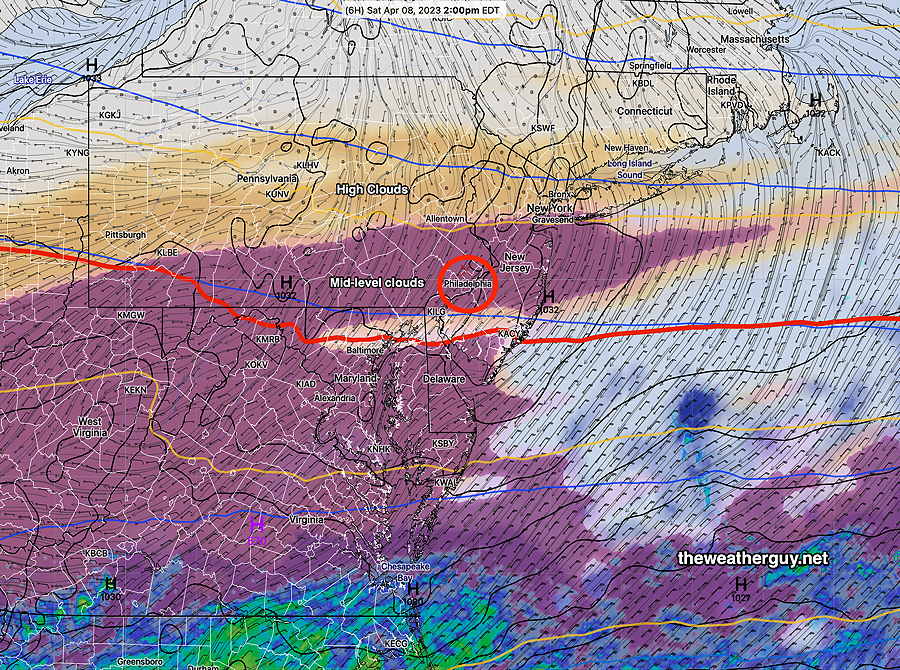
Update Sat 04/08 @ 10:23 AM — So far, my forecast of “Variable amounts of sun through high cloudiness” seems to have verified, but this morning’s early models are still forecasting more in the way of cloudiness this afternoon as moisture from the stalled front that’s south of us spills up aloft as cloudiness here.
Here’s the latest NAM-NEST cloud forecast for 2 PM—
I should mention that the Canadian HRDPS has much less cloudiness for us.
Previously Posted Fri 5:50 PM —
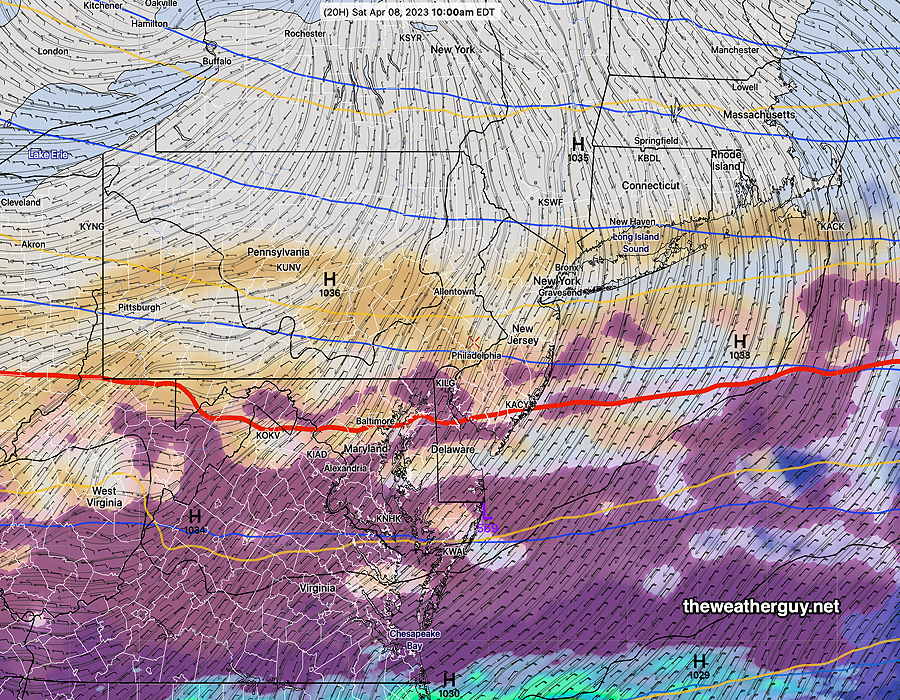
The stalled front to our south will gradually sink further south on Saturday as high pressure moves in from the north. A low pressure system on the same front will push some moisture aloft towards us on Saturday, causing high level cloudiness.
The high pressure system will bring much cooler (actually colder) weather Saturday night before temperatures rebound next week.
NAM-NEST cloud type/precip forecast for Saturday at 10 AM. High clouds (tan) and some mid-level clouds (deep purple) will skirt our area from the low moving off to the south. (Click on image for a larger view.)
Saturday
Variable amounts of sun through high cloudiness through the day. Much colder Saturday night where temperatures may approach or dip below freezing.
High temperature 52.4º sd 0.9º ( NBM model location Blue Bell, PA
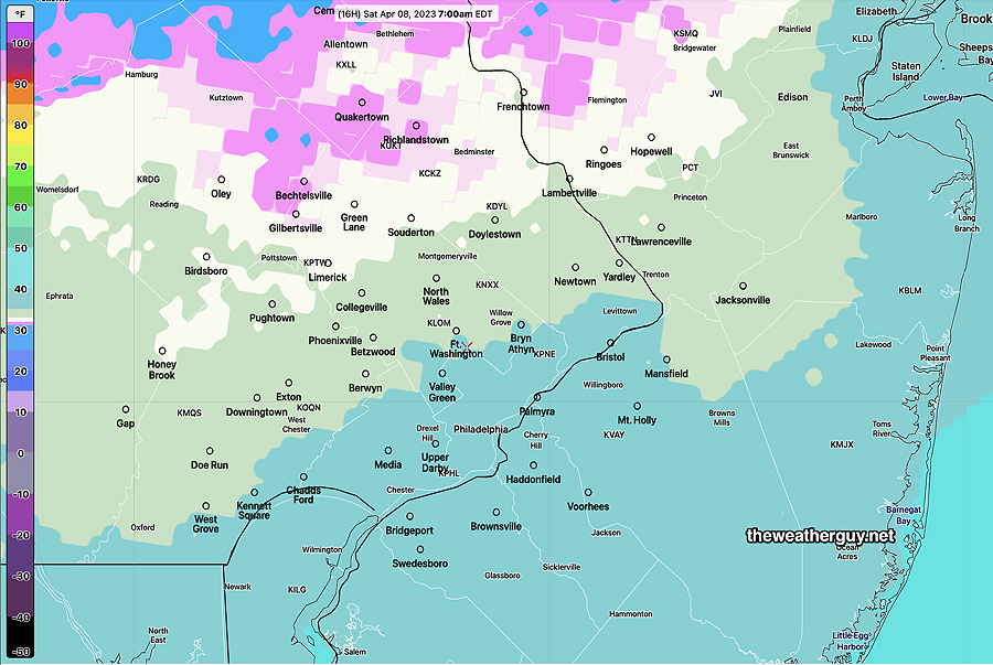
NBM low Temperatures Saturday night—
NBM low temperatures Saturday night 31-34º. The standard deviation is 1.5º -2º (Click on image for a larger view.)
Sunday
Sunny and a bit milder.
High temperature 57.2º sd 1.2º ( NBM model location Blue Bell, PA)
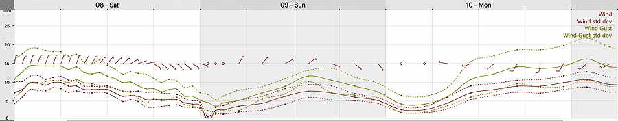
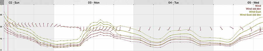
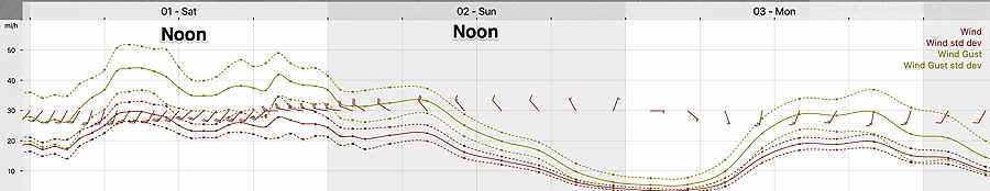
Winds
NBM Wind meteogram for Blue Bell, PA (Wings Field) (Click on image for a larger view.)
Winds subside during the day. It will be sunny and unseasonably cool.
High temperature 50.0º sd 1.4º ( NBM model location Blue Bell, PA)
12z NBM Wind meteogram forecast for KLOM Blue Bell PA (Click on image for a larger view.)
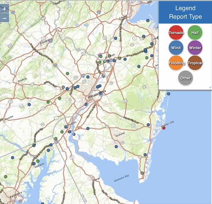
Update Sat 4/01 9:44 PM — Despite the tornadic radar ‘signatures’ seen on radar this evening (inferred from radar differential velocity), the NWS is currently not showing any actual tornado reports except off the coast, near Atlantic City—
Forecast Review
Update Sat 4/01 7:22 PM — Tonight’s storms were impressive, almost scary. Thunder/lightning was almost continuous. Small hail also thrown in for good measure. The ingredients were there. The models did well with the timing and the forecast of the severe weather possibility. The HRRR was particularly impressive, as it often is with this.
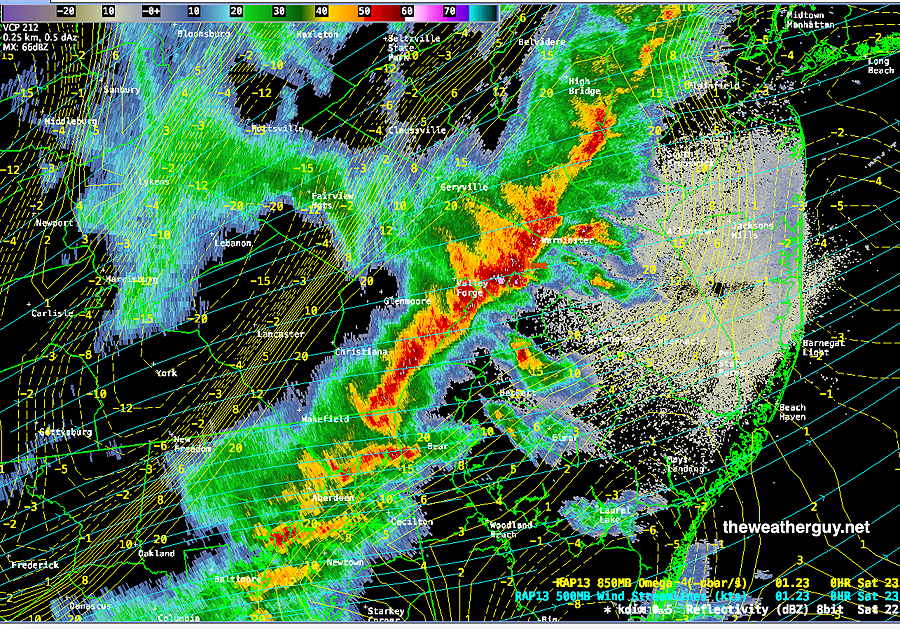
Radar with storms just entering Philadelphia 6:30 PM—
Here’s current NEXRAD radar (~ 7 PM) —
Areas of NJ will likely continue to encounter these severe storms over the next hour or so.
One more thing. The meteorologist on Channel 3 did an excellent job in covering the severe weather. Knowledgeable and impressive.
Storm Potential Update
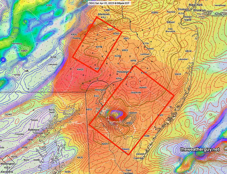
Update Sat 04/01 @ 10:25 AM — Updated with the 12z NAM-NEST which shows a different potential location of severe weather at 6PM—
12z NAM NEST shows elevated CAPE and Helicity northwest of the city at 6 PM. (Click on image for a larger view.)
Update Sat 04/01 @ 9:42 AM — The important 12z models (those with direct upper air radiosonde/weather balloon measurements) are just becoming available. The HRRR and RAP have become available.
Specifically, the HRRR shows chance of an isolated severe storm in South Jersey as early as 5 PM. The main line of storms moves in between 6 and 9 PM.
Here’s how the ‘severity’ parameters stack up compared to the major storm outbreak of Sept 2021—
9/1/2021Tornado Outbreak (example of highly severe)
Todays’s Forecast HRRR 12z
Comparative Impact
CAPE 3500-4200 Joules/kg
2100
⚑
Helicity 1350 m^2/s^2
655
⚑
Vertical Shear 40-46
40-45
⚑
Precipitable Water 2.7″
0.83”
⇩⇩
Lifted Index minus 6º K
minus 9.3º
⚑
HRRR Hail Parameter 1.9
1.4
⚑
Peak Wind Gusts 40-50
40-50
↔
Aligned Storm Motion and Shear Vectors- ~ 90º
Almost aligned
↔
Jet stream level – wavy
Highly cyclonic
↔
Jet Stream 250 mb Speed – 63
High 135
↔
500mb – Highly Cyclonic
Highly cyclonic
↔
Severity Parameters Impact: ⚑ indicates favors Severity ⚐ indicates Possible Severity ↓ indicates works against Severity ⇩ Significant, but less impact
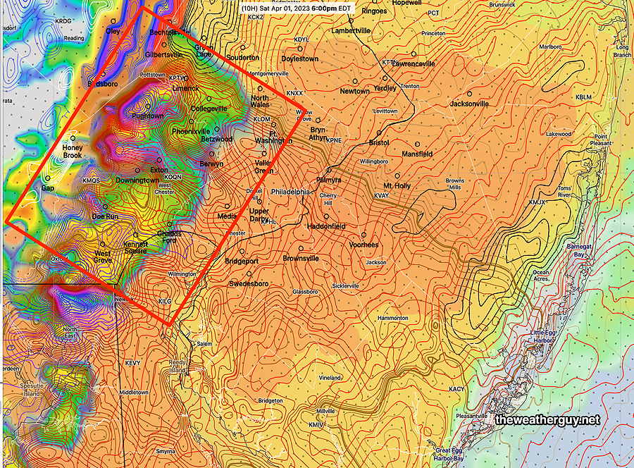
Here’s where the greatest potential for severe weather appears to be at this time (this will likely change)—
Today’s 12z HRRR CAPE/Helicity/Radar forecast for 6 PM Saturday evening. Contours represent helicity. Max helicity South Jersey means some chance of tornadic activity. (Click on image for a larger view.)
Canadian RGEM Convective (thunderstorm) Precipitation Forecast 7 and 8 PM snapshots—
Update Sat 4/01 7:51 AM — Last night’s models continue with an increased possibility of severe weather this evening. The new 12z HRRR will become available about 9:35 AM. I’ll update before 10 AM.
Update Fri 3/31 10:49 PM — Tonight’s models are showing storm severity parameters that are more impressive for Saturday evening’s storms than previous model runs—
9/1/2021Tornado Outbreak (example of highly severe)
Severity Parameters Impact: ⚑ indicates favors Severity ⚐ indicates Possible Severity ↓ indicates works against Severity ⇩ Significant but less impact
Previously Posted Fri 8:52 PM —
Low pressure will move northeast of us on Saturday. Warm air will be brought up over us from the southwest with rain in the morning. A strong pressure gradient will bring strong and gusty winds. A dry slot from the low will bring some sunshine in the afternoon.
A fast moving cold front moves through early Saturday evening with showers and thunderstorms
Saturday
Rain in the morning, rapidly ending about 12-1 PM from west to east. Sunshine breaks out from the dry slot associated with the low pressure system in Canada.
A strong cold front moves through between 6 PM and 8 PM with showers and thunderstorms. Some storms. especially from Philadelphia and eastward into NJ, will be strong, although severe weather not expected. The big issue may be the winds.
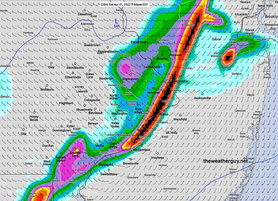
The HRDPS shows a fast moving line of storms at 7 PM Saturday—
Today’s 18z HRDPS shows a line of heavy rain at 7 PM . This will be a fast -moving line. (Click on image for a larger view.)
High temperature 71.3º sd 2.7º ( NBM model location – Blue Bell, PA)
Wind Meteogram (19z NBM) for Blue Bell PA 40-53 mph winds possible (Click on image for a larger view.)
Sunday
Following Saturday’s cold front, winds subside during the day. It will be sunny and unseasonably cool.
High temperature 50.6º sd 2.2º ( NBM model location Blue Bell, PA)
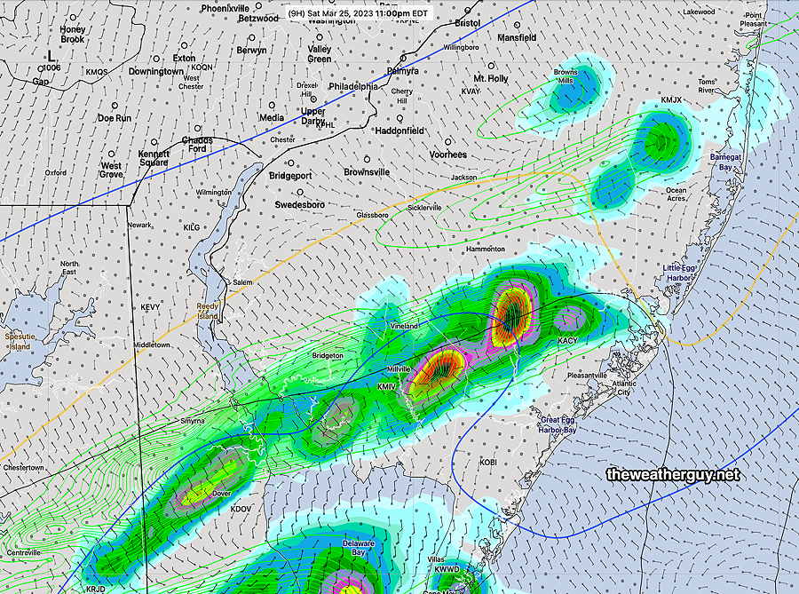
Update Sat 03/25 @ 4:38 PM — The models have backed away from thunderstorms developing in the immediate PHL area. The area of development may be South Jersey, about 10 PM
This afternoon’s 18z HRRR shows thunderstorms developing about 10-11 PM in South Jersey. Little to no activity in the immediate PHL area. (Click on image for a larger view.)
Sunday looks suuny. A bit windy. Temps upper 50s to near 60.
Update Sat 03/25 @ 10:33 AM — There have been some changes in the forecast.
The rain will be moving in over the next hour or so. Rain ends about 5-6 PM. Total rainfall about 0.2-0.5 inches. A second batch of rain and thunderstorms about 9-11:30 PM
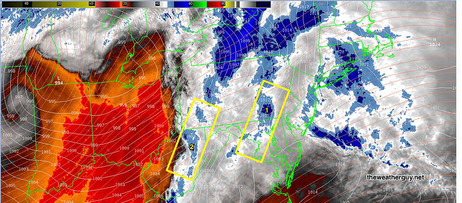
Here’s the current water vapor image. The first boxed area (1) is the area of upward motion bringing the rain in the next few hours. The second boxed area (2) may bring some thunderstorms between 9-11:30 PM, (maybe missing the immediate PHL area, maybe not.) Some model uncertainty in the placement of the second batch of rain/thunderstorms.
Update Fri 3/24 11:20 PM — Tonight’s models show breaks in the rain Saturday with total rainfall on the light side. The warm front gets further north and temperatures rise to upper 50s late afternoon.
Update Fri 03/24 @ 7:59 PM — Minor update to include the mention of thunderstorms mid-day with the rain. The latest models have very high levels of helicity and vertical shear, greater than that which spawned Thursday evening’s surprise thunderstorms . Nothing severe expected because CAPE values are expected to be low.
The cold front that moved through Friday night has stalled to our south and will try to return as a warm front later Friday night as a cold front moves in from the northwest later on Saturday.
It appears that the warm front won’t make it north of our area, as low pressure is expected to form near the Delmarva coast.
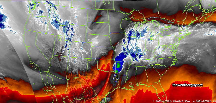
Water Vapor image at 4 PM shows large storm in Mississippi Valley and significant water vapor flow into our area. This will affect us on Saturday. (Click on image for a larger view.)
The warm front, the low pressure system and the cold front will result in periods of rain for much of Saturday. Thunderstorms appear possible Saturday evening, especially north and west of the city.
Saturday
Cloudy with rain becoming heavier late morning and continuing on and off during the day. Some thunderstorms mixed in with the rain possible mid day. Becoming very WINDY and gusty. Scattered thunderstorms again possible between 6 and 10 PM, mostly northwest of the city. Clearing after midnight.
High temperature 53.5º sd 2.4º ( NBM model location – Blue Bell, PA)
Sunday
Sunny and mild. Still quite windy.
High temperature 60.3º sd 1.7º ( NBM model location Blue Bell, PA)
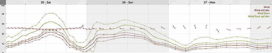
Winds
Strong wind gusts about noon-2 PM Saturday. Large wind shift about 10 PM signifies cold front passage. (Click on image for a larger view.)