All posts by GFS

THIS WEEK’S WEATHER

Friday Update

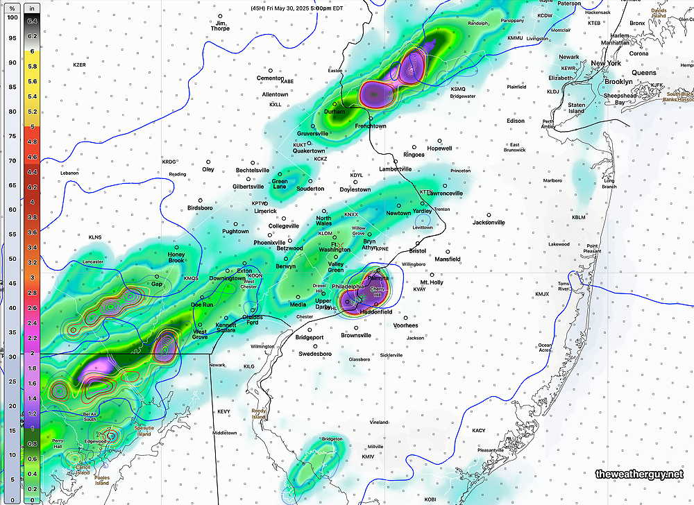
Posted Friday 05/30/25 @ 9:53 AM — The clouds should break for sunshine from west to east about 11 AM to noon. Cloudiness develops again about 4-5 PM. Light rain moves in about 7-9 PM. Heavier rain and possibly severe thunderstorms move in about 9 -11 PM Friday evening, according to the latest HRRR.

Today’s 12z HRRR forecast simulated radar- 10 PM Friday evening. (Click on image for a larger view.)

(Problems with NOAA’s supercomputers have been an issue over the past 18 hours, hopefully resolved. This has prevented availability of the RRFS and REFS.)


Update Thu 5/29 10:44 PM — Tonight’s early models suggest that Friday will be relatively rain free. Minimal isolated showers. Heavy rain and potentially severe storms move in and develop in place over our area beginning 6-8 PM.


Active Unsettled Weather Friday Saturday

Posted Thursday 05/29/25 @ 5:27 PM — Several pieces are coming together for some active weather (heavy rain, thunderstorms) beginning later Thursday night through at least Saturday.

The jet stream is forecast to dive south into a sharp trough (somewhat unusual for late Spring). This feature along with a southern stream jet flow will provide energy to spawn low pressure, rain and thunderstorms. Add to this an increasingly moist air flow with some forecast helicity, wind shear and the ingredients are in place for potential severe weather and heavy rainfall.

Today’s 12z ECMWF jet stream flow shows strong jet streak diving south and interacting with south jet flow, spawning waves of low pressure. (Click on image for a larger view.)

Timing of these soon-to-be spawned low pressure waves will be less than exact. As mentioned, the first wave moves through Thursday night with showers and some thunderstorms, ending early Friday morning.

A break in the action looks likely Friday morning, but there’s the possibility of some scattered storms forming Friday afternoon. The heavy action now appears to occur Friday evening and night, where severe thunderstorms are possible, especially in NJ. Rain and thunderstorms continue into Saturday. We may get a break on Sunday.

I expect to hear a few severe thunderstorm announcements over the next two days. Stay tuned.


Clearing Thursday- Possible Severe Storms Friday Afternoon

Posted Thursday 05/29/25 @ 8:42 AM — Sky conditions are expected to improve over this afternoon. Cloudiness will become quite variable in many areas between 2 and 5 PM. Enjoy while you can.

More clouds and what looks like possible severe storms Friday afternoon into Friday evening.

RRFS forecast Precipitation rate and upward helicity at 5 PM Friday. Suggestive of severe storm potential. (Click on image for a larger view.)

Wednesday -Thursday Update

Posted Wednesday 05/28/25 @ 4:33 PM — I rarely use the popular TV weather phrase “I’m tracking this [on radar]” to describe the progression of weather.

“Tracking” suggests to me a very non-dynamic process with weather moving from point A to point B, like on a train track. Indeed, the hourly rain depiction on the iPhone weather widget is that level of weather ‘forecasting’. Weather forecasting is much more complex than this.

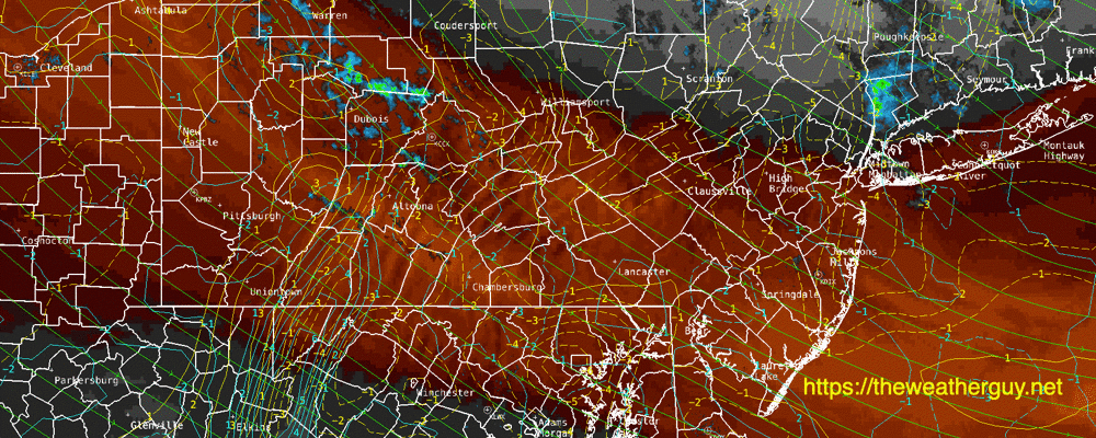
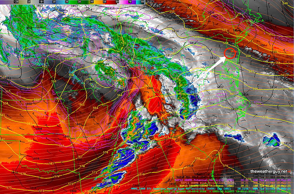
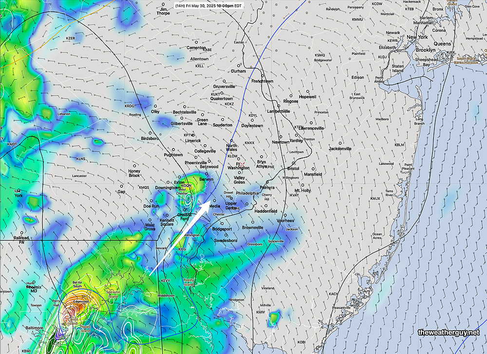
Case in point is the current radar, which shows the back edge of the rain moving towards us at 4 PM. So, why did they postpone the Phillies game for this evening?

The reason is rain is expected to redevelop over us and increase in intensity despite the back edge visible on radar at this time.

Composite RADAR with RAP model parameters superimposed at 4 PM. Yellow contours depict vertical velocity. (Click on image for a larger view.)

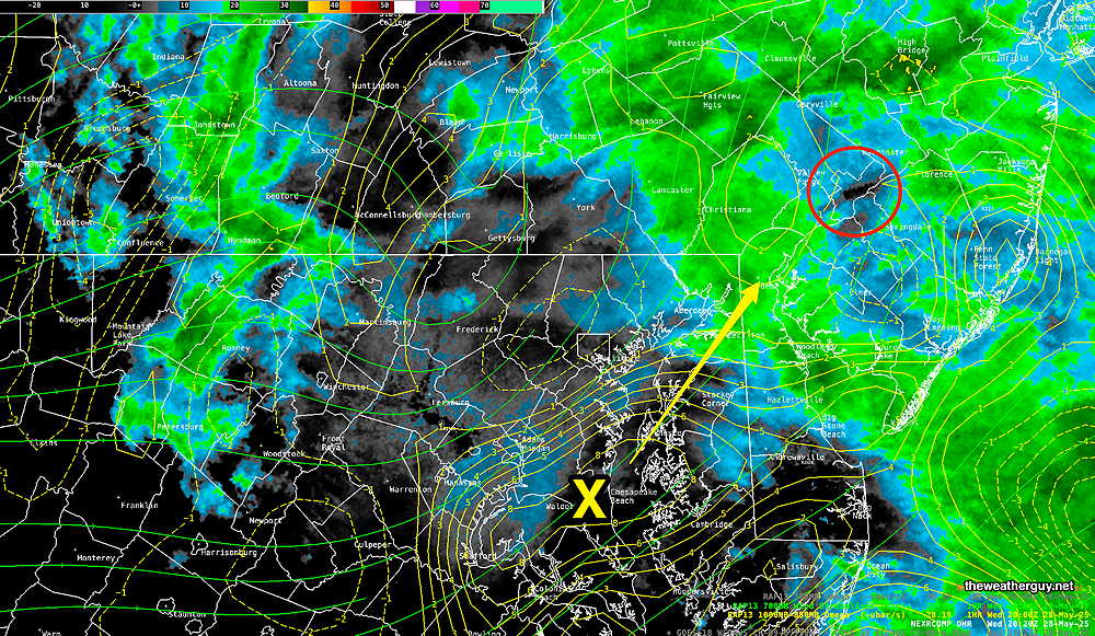
The above radar image above includes RAP model vertical velocity (yellow X) which is expected to move over us during the early evening hours. Heavier rain is expected to redevelop with this dynamic in place Wednesday evening. (I guess we’ll see if it happens.)

The rain is expected to depart by the early morning, but low clouds will linger for much of the day Thursday.

Another possibly heavy rain maker is forecast to begin mid afternoon Friday.


Wednesday’s Rain

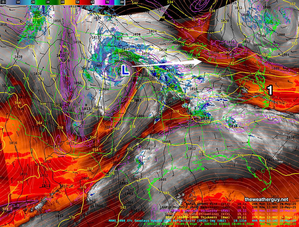
Posted Tuesday 05/27/25 @ 6:10 PM — This afternoon’s models are predicting remarkably similar rainfall totals for Wednesday, with higher rainfall to our south (a trend that has been consistent as well.)

To mix it up a bit, here’s the HREF ensemble model rainfall totals through 8 AM Thursday—

Today’s 18z HREF model rainfall forecast through 8 AM Thursday. (Click on image for a larger view.)

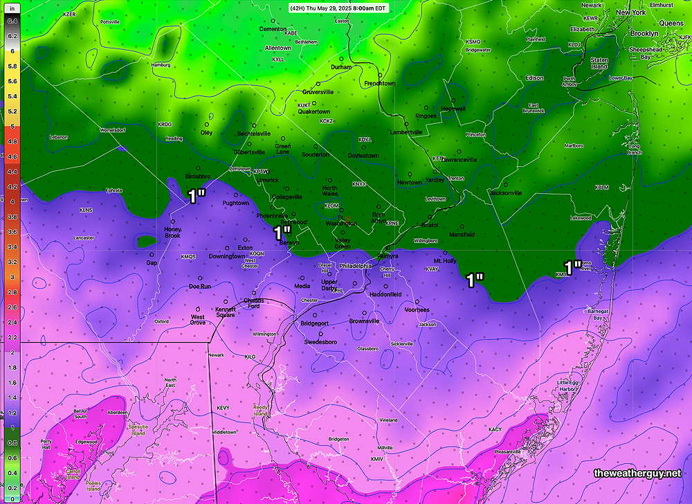
With the exception of the Canadian RGEM, most models have rain starting around daybreak Wednesday. As for the Phillies game Wednesday evening, it looks like the rain doesn’t taper until late evening.

The rain ends early Thursday morning, but plenty of clouds are forecast for much of the day, possibly breaking to some sunshine or bright skies late Thursday afternoon.


Tuesday-Wednesday Forecast Update

Posted Monday 05/26/25 @ 7:29 PM —It appears that cloudiness will advance earlier into our area Tuesday than previously forecast. Considerable cloudiness is expected during the morning, with thickening and lowering cloudiness during the day.

Many models have some light sprinkles after midnight into early Wednesday morning with heavier rain developing by late morning and during the afternoon. An easterly wind will make it quite chilly on Wednesday.

Rain will continue Wednesday evening and taper off Thursday morning. Slow clearing with a chance of a shower through Thursday.

12z RRFS-A (pre-release version) total rainfall through Thursday/ (Click on image for a larger view.)

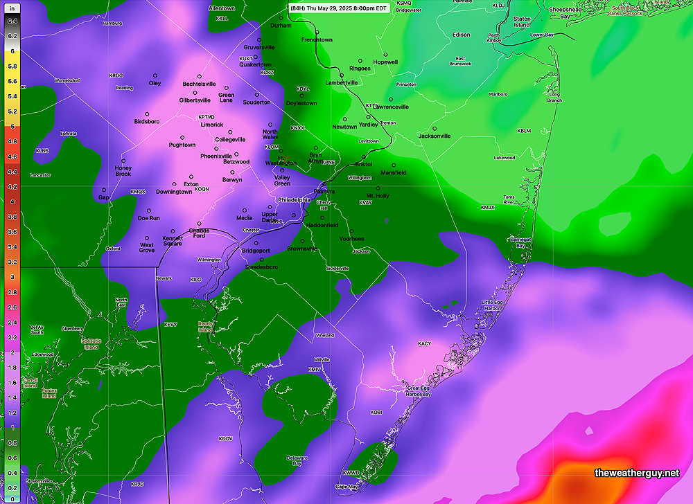
The GFS, Canadian, ECMWF and RRFS are forecasting close to 1+ inch of rain total around Philadelphia, less amounts to our north. The AI versions of the ECMWF and the GFS show lesser amounts, about 0.5-0.75 inches with the heaviest rain south of our area.


Memorial Day through Wednesday

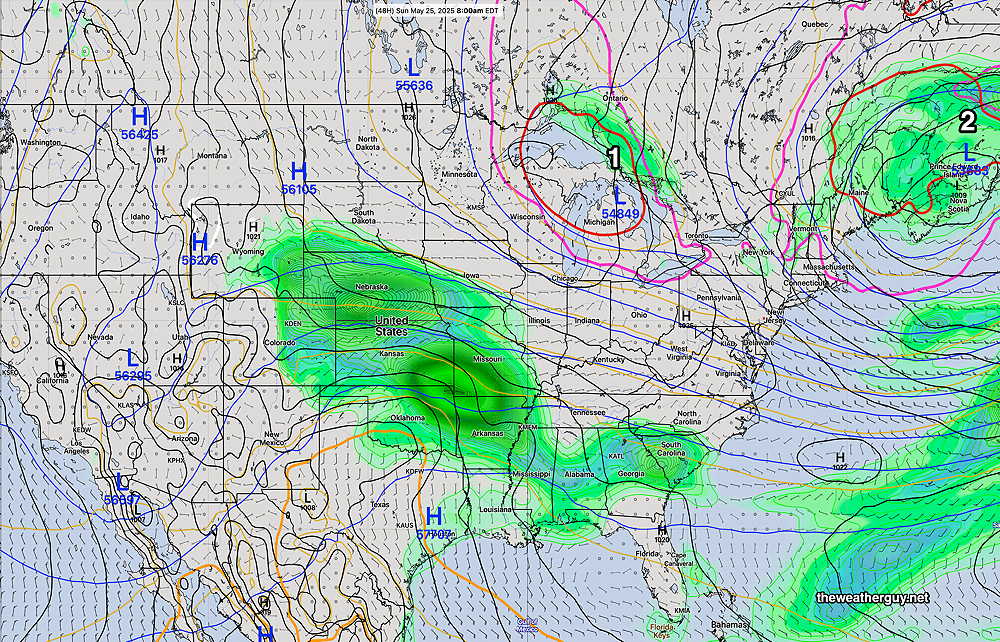
Originally Posted Sun 7:53 PM —Low pressure that slowly departed our area will still influence our weather on Monday, Memorial Day. We’ll see plenty of sunshine Monday, but several models are hinting at some cloudiness developing mid-afternoon into the evening as a short wave associated with the departing low rotates through.

The GFS and pre-release RRFS model show the possibility of a few isolated showers between 3 PM and 8 PM. Most areas will be dry. (The Canadian HRDPS keeps these showers far north of our area.)
(Updated Sunday 05/25/25 @ 9:12 PMSeveral more of this afternoon’s models keep any isolated showers to our far north.)

12z RRFS-A (pre-release) model forecast for 8 PM Monday. (Click on image for a larger view.)

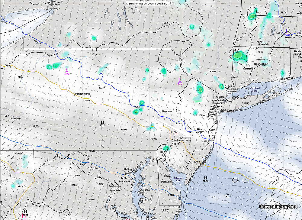
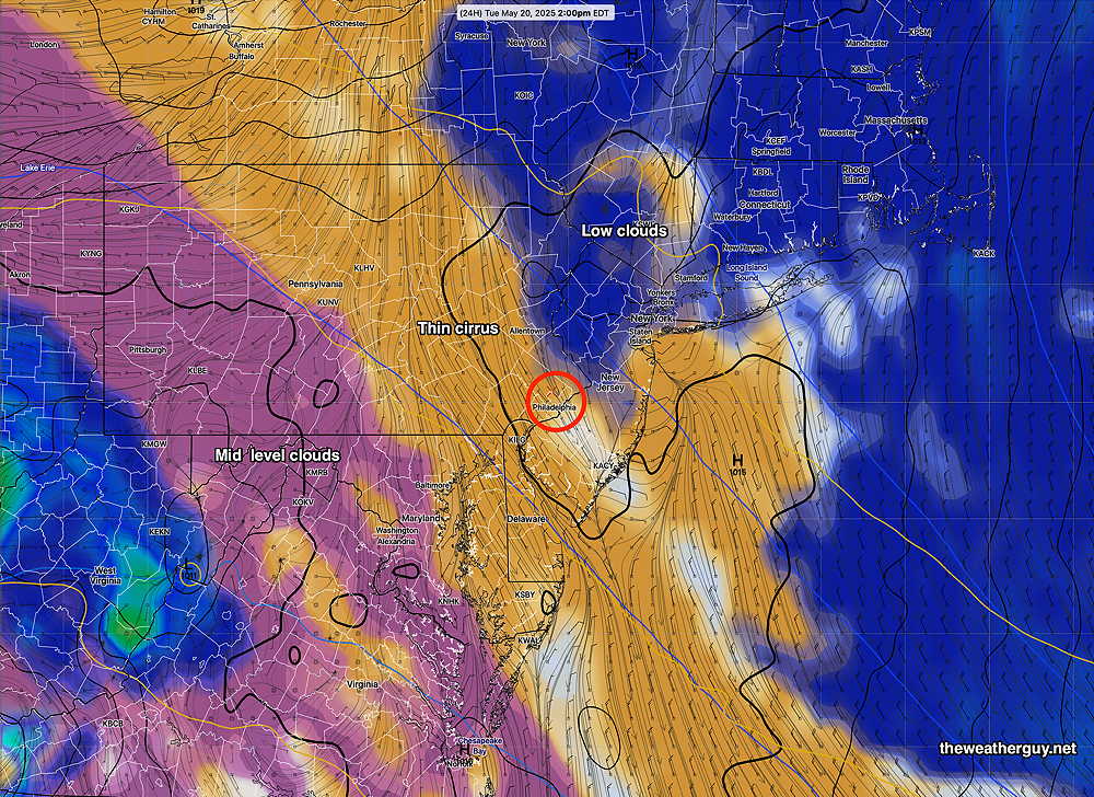
Tuesday will have sunshine through high cirrus clouds ahead of an approaching low pressure system. (Areas south of the city and in South Jersey may have considerable mid-level cloudiness.)

Also expected Tuesday is an updated NBM model, which will be moving to NBM version 4.3. This updated model will have several enhancements, including an update to cloud cover and improvements in forecasting tropical systems and severe weather.

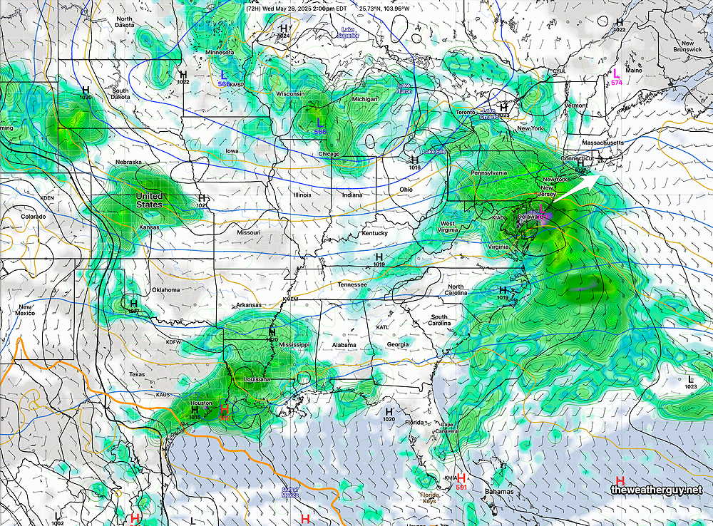
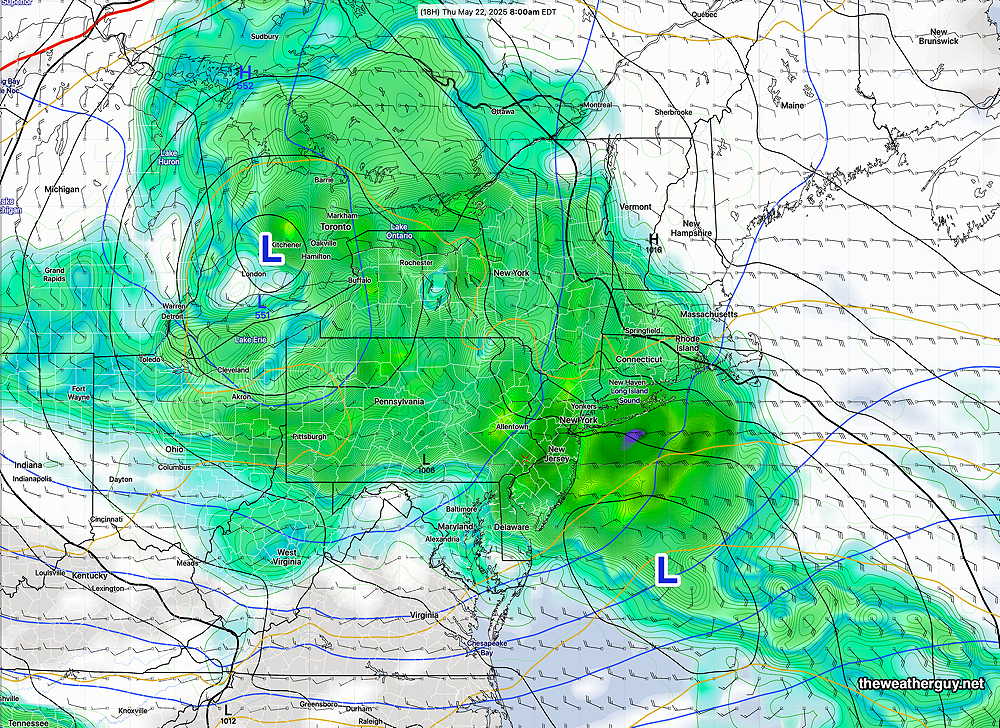
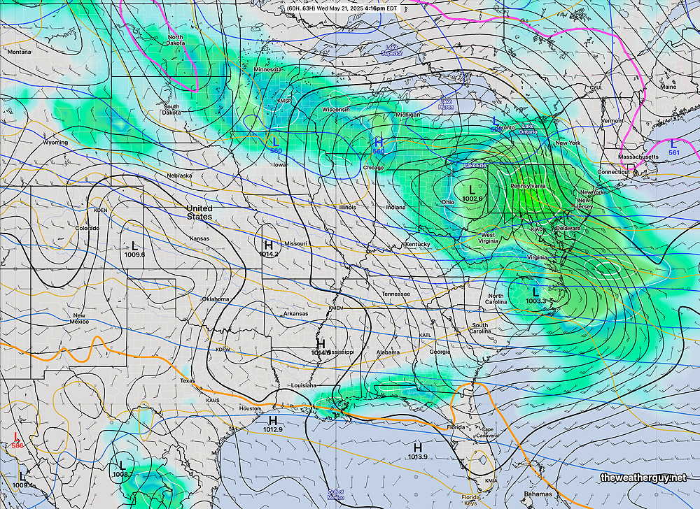
Here’s the storm taking shape in the Central US as of Sunday evening —

Sunday evening satellite water vapor image with superimposed RAP model 500-1000 mb thickness lines (yellow), Mean Sea Level Pressure isobars (black contours) potential vorticity (fine violet contours) with superimposed MRMS RADAR. Storm taking shape in south central US. (Click on image for a larger view.)

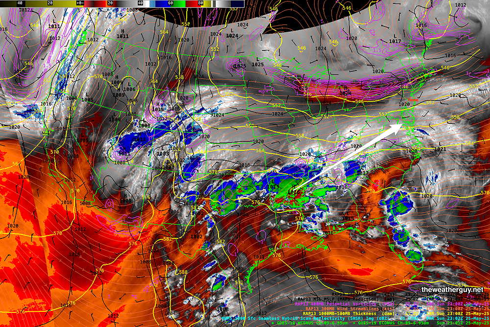
This storm will bring rain to our area Wednesday. The trend has been for the heaviest rain to move to the south of our immediate area. About 0.5 inches of rain are expected.

Latest GFS forecast for Wednesday (Click on image for a larger view.)


WEEKEND WEATHER FORECAST

Saturday Update

Posted Saturday 05/24/25 @ 9:37 AM — Last night’s forecast still holds. The sunshine this morning will be mixing with clouds by about noon. There’s a chance of an isolated, fast moving light shower about 3-5 PM. although most areas are expected to remain dry.

Current Water Vapor with Radar shows the disturbance expected to move through—

Water Vapor, radar composite and RAP model vertical motion around 9:15 this morning (Click on image for a larger view.)

Previously Posted Fri @ 6:19 PM — —The main low pressure system that affected our weather over previous days is slowly moving away, but the first upper low and a second upper low will bring cool weather and unsettled skies at times through the first portion of the Memorial Day Weekend. Monday should be mostly sunny.

(An upper low can be thought of as a cold circulation of air aloft.)

ECMWF-AI forecast for Sunday at 8AM 1 and 2 are upper low pressure systems. The red lines are called 540 thickness lines, and they demarcate colder average temperatures of the lower half of the atmosphere. In winter, areas north of the 540 thickness lines are cold enough for snow. In late spring, that cold air causes instability to develop with sunshine heating the ground. (Click on image for a larger view.)

We had widely scattered fast moving showers late this afternoon, and with cold air aloft, that possibility still exists for Saturday afternoon. Sunday, any instability showers should remain far north of the Philadelphia area.

It should be noted that any really warm weather isn’t forecast for our area this weekend or even for the coming week.

Saturday Forecast

Sunny in the morning. Instability cloudiness develops before noon and lasts several hours into the afternoon. A few, isolated showers move through at that time. Most areas will be rain-free. It will be windy during the mid-day hours.

NBM high temperatures: Blue Bell, PA 63º Philadelphia, PA 66º
Uncertainty:average (based on standard deviation): ± 1.9º

Sunday Forecast

Partly sunny, although the experimental RRFS shows considerable cloudiness south of the city and in Southern NJ. Less windy but still breezy.

NBM high temperatures: Blue Bell, PA 68º Philadelphia, PA 70º
Uncertainty: average (based on standard deviation): ± 1.8º

Memorial Day

Sunny. Winds subside further but still breezy. High thin cirrus clouds move in late afternoon.

NBM high temperatures: Blue Bell, PA 68 72º Philadelphia, PA 74º
Uncertainty: low (based on standard deviation): ± 1.4º


THIS WEEK’S WEATHER

Friday & Weekend Outlook

Update Fri 5/23 8:51 AM — The latest RRFS model runs keep most of the day dry with clouds and breaks of sun. Scattered showers become more numerous after 5 PM into the early evening.

Posted Thursday 05/22/25 @ 5:43 PM — Rain continues to rotate around the main area of low pressure. This system will eventually move off to the northeast over the next 48 hours.

Current satellite water vapor image with superimposed RAP model 500-1000 mb thickness lines (yellow), Mean Sea Level Pressure isobars (black contours) potential vorticity (fine violet contours) with superimposed MRMS RADAR. Low pressure moves off to the northeast over the next 48 hours. (Click on image for a larger view.)

Friday: Relatively cold air aloft will move in behind the system during the first two days of the weekend. Looking at the best match for Friday’s forecast, it appears that we may see some sun at times Friday morning. Cold air aloft will cause enough instability for clouds to form with scattered showers in the afternoon, especially mid to late afternoon.

It will be windy and gusty. Cool! High near 65º

Saturday: Cold air aloft will result in considerable low clouds (stratocumulus) especially by later morning and during much of the afternoon. There’s still a chance of light scattered showers. It will be windy and gusty. High near 65º

Sunday: More sun, but still periods of some cloudiness. Still breezy/windy. High near 67º

Monday: Mostly sunny. High near 68º


Thursday and Friday

Posted Wednesday 05/21/25 @ 7:43 PM — A secondary coastal low is expected to form tonight and will bring heavier rain tonight into Thursday.

Today’s 18z GFS forecast for 8 AM Thursday. Secondary low develops off the NJ coast. (Click on image for a larger view.)

A line of heavier rain is moving through Central Pennsylvania this evening and will arrive here later this evening.

Thursday will have periods of rain on and off during the day and into the evening hours.

Friday will still be cloudy, windy and chilly with a chance of showers, especially in the afternoon.

The weekend will feature gradual clearing. Plenty of clouds on Saturday and even Sunday may have some cloudiness develop mid day due to instability. Monday looks to be the best day. It will be chilly and windy much of the weekend; it won’t feel like the beginning of summer.


Wednesday Thursday Forecast

Posted Tuesday 05/20/25 @ 6:02 PM —Rain moves in from the southwest, reaching us between 7 and 9:30 AM on Wednesday.

YES, THE UNIDATA SERVER IS AGAIN UP AND RUNNING. BUT FOR HOW LONG? Current satellite water vapor image with superimposed RAP model 500-1000 mb thickness lines (yellow), Mean Sea Level Pressure isobars (black contours) potential vorticity (fine violet contours) with superimposed MRMS RADAR. (Click on image for a larger view.)

(The onset of the rain has moved later with each model run.) Wednesday looks rainy for most of the day, perhaps with some breaks at times. Heaviest rain likely during the afternoon hours.

A possible break in the action Wednesday evening, then more rain, on and off through much of Thursday. Thursday’s rain will likely be more showery and intermittent than Wednesday.

It will be windy and become gusty, especially Wednesday night into Thursday morning.

About 1 inch or more of rain is expected.

Improving conditions on Saturday through Monday. Saturday will be quite cold and windy.


The Trump Administration is withholding National Science Foundation (NSF) funds. The MRMS and live Satellite Water Vapor data I post here is from Unidata, funded by the NSF. The data has become “temporarily unavailable” as of this afternoon, as announced two weeks ago. The support teams for the servers have been furloughed, placed on temporary leave.

So, no more MRMS rain totals and fancy model superimposed water vapor until….

I don’t want to get political here. But what’s going on makes me angry and sad.

Tuesday Update

Posted Monday 05/19/25 @ 8:36 PM — We had much more cloudiness for much of the morning and early afternoon today than forecast by any model. Skies eventually cleared.

For Tuesday, the approaching system has slowed down and it appears that any rain will wait until daybreak Wednesday.

In the mean time, we’ll start sunny Tuesday morning, but we’ll be sandwiched between low clouds to the north and advancing middle level clouds to the southwest. So we’ll go with sunshine in the morning and sun through high cirrus clouds in the afternoon. It wouldn’t take much for the cloud forecast to be off tomorrow.

Today’s 18z GFS shows us sandwiched between low clouds and mid level clouds Tuesday afternoon. It wouldn’t take much for the cloud forecast to be wrong. (Click on image for a larger view.)

It should be much less windy on Tuesday compared to Monday.

Rain on Wednesday into Thursday. Over an inch is forecast. See this morning’s forecast immediately below for the weekend sneak peak.


This Week & Memorial Day Weekend

Originally Posted Mon 9:42 AM —Currently a low pressure system is gathering strength and moisture near Nebraska and will move eastward—

Current satellite water vapor image with superimposed RAP model 500-1000 mb thickness lines (yellow), Mean Sea Level Pressure isobars (black contours) potential vorticity (fine violet contours) with superimposed MRMS RADAR. (1) indicated where a secondary low will be spawned. (Click on image for a larger view.)

A secondary low will develop along the eastern Mid-Atlantic from this system. Rain will move in, about 5 AM Wednesday morning and linger in some form at least through Thursday evening and even Friday.

NAEFS model statistical “mode” version with overlaid GEFS model “bias-corrected” precipitation forecast for Wednesday_ (Click on image for a larger view.)

Over an inch of rain is expected with this system.

The big question is the Memorial Day Weekend. The AI model (ECMWF-AI Single) is showing a cut off closed low hanging back, bringing chilly temperatures and the chance of showers even through Saturday.

ECMWF-AI forecast for Saturday afternoon. Closed low off the New England coast with instability showers expected here.

Things look better for Sunday and Monday.

A note for those of you who are visiting this site from “X“.
Due to the highly unbalanced political environment on X, I’ve considerably cut back auto-posting there. To receive all my forecast postings, I recommend following me on mastodon.social or bluesky.social