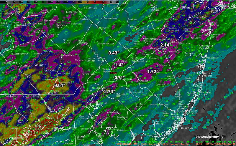
Sun 9:35 AM —Forecast Review —MRMS rainfall 24 hours through 9 AM Sunday—
MRMS rain-gauge measured rainfall combined with rain-gauge calibrated and interpolated radar-based summary of ACTUAL RAINFALL RECEIVED. Color shading is in inches. Line contour numbers are in mm. (25.4 mm= 1 inch) (Click on image for a larger view.)
Sunday Forecast Update
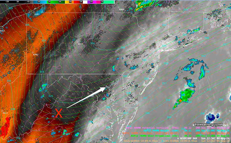
Posted Sunday 08/04/24 @ 9:01 AM — The upper level trough axis will move across our area today. An area to our southwest is expected to generate disturbances that will lift towards us causing showers and thunderstorms in our area. Most of the heaviest rainfall will be from the city and eastward in NJ.
This morning’s water vapor image with superimposed RAP model 700 mb data. Area designated X at the base of the upper trough will generate showers and thunderstorms that will lift northeastward towards us. (Click on image for a larger view.)
Showers and thundershowers are expected later this morning and again by 1-3 PM. Some may be heavy.
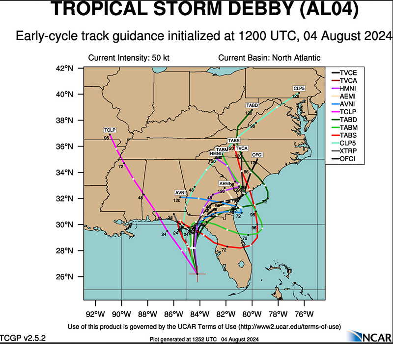
I’m watching the development of likely Hurricane Debby. There’s much uncertainty with the track of this storm, but after hitting Florida, it may redevelop around the Georgia/South Caroline coastline and even move westward due to blocking by the large Bermuda High Pressure system. Remnants of this storm have a good chance of affecting our area later in the week, but the timing is quite uncertain at this time.
Posted Saturday 08/03/24 @ 4:01 PM — A quick update. The latest models show several ingredients present for possible severe storms early this evening.
Shear, CAPE and updraft helicity are all elevated from just west of the city into NJ. The HRRR shows echo tops up to 48,000 feet, meaning strong thunderstorms, possible hail.
Heavy rainfall possible with some storms. Expected to move into western Chester, Montco, Bucks counties about 5-5:30 PM or so, then into the city about 6-7:30 PM.
Posted Saturday 08/03/24 @ 9:22 AM — A mix of sun and clouds expected through much of the day. The Canadian and ECMWF models have a few isolated showers early afternoon; Our HRRR and RRFS have little shower/no or storm activity until after 5 PM. Either could be correct.
A line of storms is expected to form late afternoon into early evening, similar to Friday’s showers. Exact timing didn’t work yesterday and might not work again today. That said, peak activity 6-9 PM. Rainfall may be heavier and more widespread this evening than yesterday.
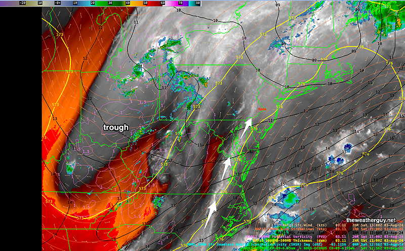
Water Vapor this morning shows a line of weak disturbances to affect us later today—
Current satellite water vapor image with superimposed RAP model 500-1000 mb thickness lines (yellow), Mean Sea Level Pressure isobars (black contours) potential vorticity (fine violet contours) with superimposed MRMS RADAR. (Click on image for a larger view.)
A similar situation expected for Sunday.
The tropical system taking shape along the western Florida coast may affect our weather Thursday into Friday.
Originally Posted Fri @ 8:15 PM — —A southwesterly flow of moisture and an upper level trough will combine with small mid-level disturbances to bring clouds and showers/thunderstorms for Saturday and Sunday.
GFS 700 mb forecast at 8 PM showing ‘shortwaves’ (L) that are forecast to lift towards our area over the weekend.
The models weren’t stellar with the forecast timing for Friday’s showers/storms. I expect that other issues will arise with this weekend’s forecast.
Saturday
Some sun in the morning. Increasing clouds during the early afternoon. Scattered showers and thunderstorms will develop around the area.
NBM high temperatures: Blue Bell, PA 90º Philadelphia, PA 93º Uncertainty (based on standard deviation): ± 3º high uncertainty
Originally Posted Fri @ 8:15 PM — —
Sunday
Mostly cloudy, some bright spots at times. Scattered showers and thunderstorms for much of the day, ending late afternoon.
NBM high temperatures: Blue Bell, PA 86º Philadelphia, PA 88º uncertainty (based on standard deviation): Average to low.