THIS WEEK’S WEATHER

#Phillywx #Philadelphia #weather #PAwx

Friday, The Weekend

Posted Thursday 11/30 @ 8:06 PM — A series of disturbances will approach our area ahead of cold front that eventually gets here on Monday.

For Friday, some sun early through high clouds, then cloudy by noontime. Rain moves in about 2:30 PM to 5 PM from the west.

The rain departs by Saturday morning. A strong southwesterly flow of warm air will allow temperatures to reach 62º Saturday before clouds thicken ahead of the next disturbance Saturday evening. Most of the daytime Saturday will be rain-free.

Rain develops later Saturday night into Sunday, tapering off late afternoon or evening but there’s uncertainty in the timing of these disturbances on Sunday and beyond.

The ECMWF is most aggressive with secondary low formation near us—

Today’s 12z ECMWF shows a secondary low off of the NJ coast at 7 PM Sunday evening. This is the most aggressive forecast regarding rainfall here. (Click on image for a larger view.)

The GFS has a faster and less developed system at 7 PM on Sunday evening—

Today’s 18z GFS shows the secondary low further northeast at 7 PM Sunday evening. Notice the wavy isobars (“baggy isobars’) that suggests additional low pressure wave development to our south and an uncertain forecast. (Click on image for a larger view.)

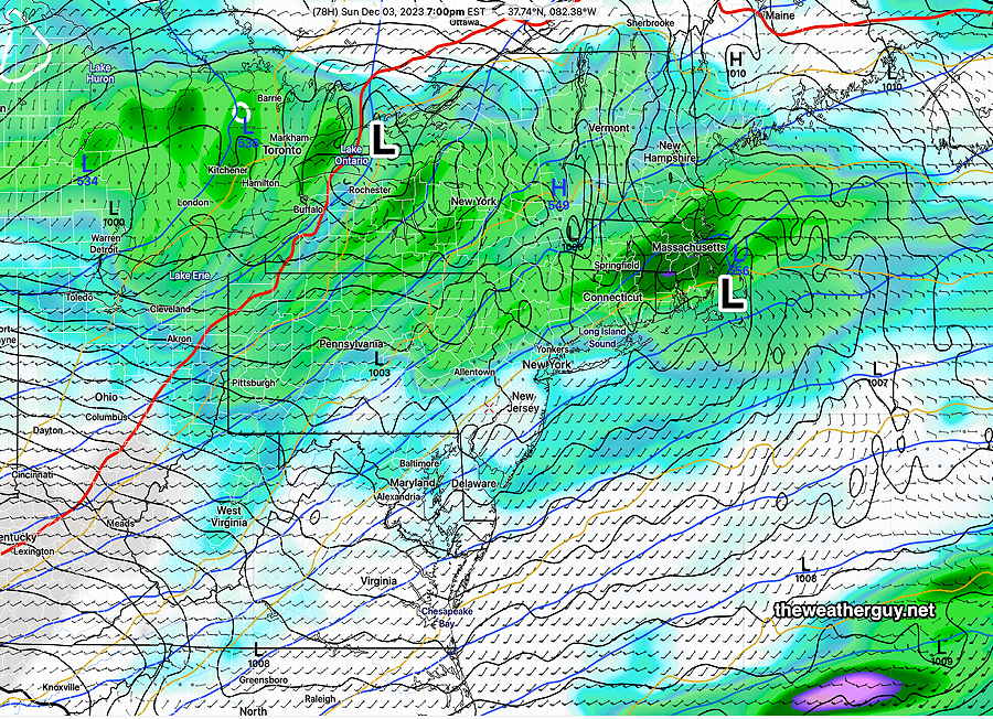
So there’s an interesting setup for the next several days with large swings in temperature and uncertainty in secondary low development.

In the Monday through Wednesday time frame, it will get cold with snow flurries likely at some point. Another big warm up for next weekend!


Thursday, Friday, The Weekend

Posted Wednesday, 11/29 @ 5:18 PM

A gradual warm up is expected Thursday and Friday with high temperatures expected to reach 49-51º Thursday and Friday. Cloudiness is expected on Friday and showers are possible late mid afternoon ahead of the next system to affect our area.

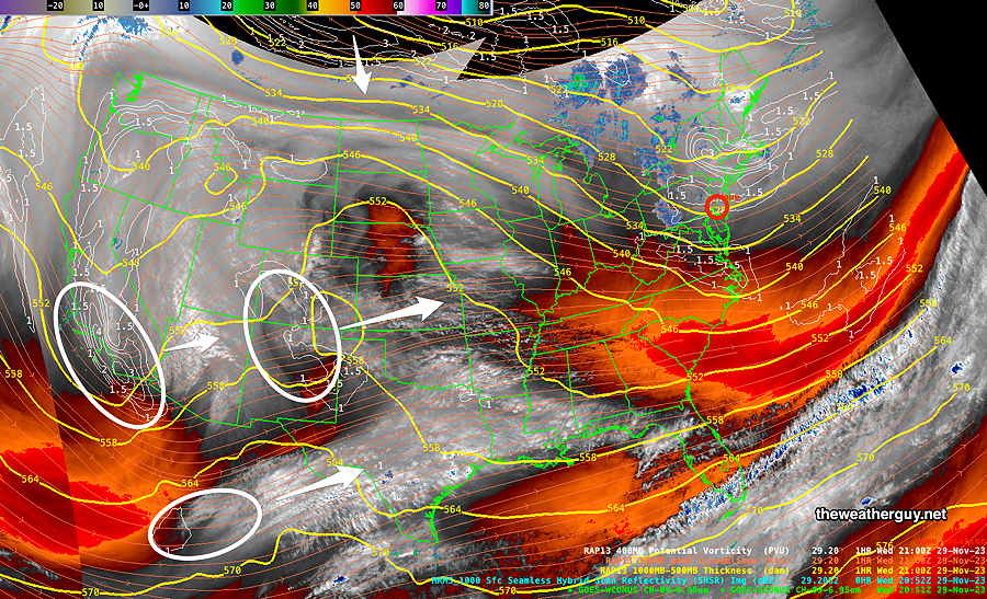
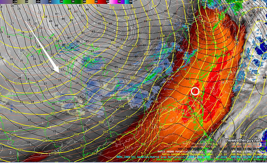
This afternoon’s water vapor image shows developing disturbances that will bring the light rain late Friday and additional rain likely on Saturday—

Current satellite water vapor image with superimposed RAP model 500-1000 mb thickness lines (yellow), jet level wind streamlines (orange contour-arrows) potential vorticity (fine white contours) and superimposed MRMS radar. Developing disturances out west (circled in white) will bring rain late Friday and again Sunday. The arrow in Canada depicts the expected movement of another cold air mass later in the weekend. Early next week looks somewhat stormy.

Speaking of next week’s possible storminess, I’ve been doing some additional thinking about the coming winter. I’m planning to put together a separate page for my winter outlook.


Hey, how come no one else predicted these flurries??
Snow Flurries are Here

Update Tue 11/28 @ 8:24 AM

The light snow flurries should be ending shortly. Some additional flurries possible this afternoon, but the models have backed off of that somewhat.


First Snow Flurries of the Season

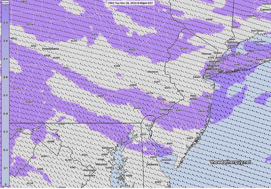
Update Mon 11/27 11:10 PM — Tonight’s models show some snow flurries during the morning hours in the northwest suburbs and again at times during the afternoon.


Update Mon 11/27 @ 9:21 PM — A very intense cold flow of air will bring instability cloudiness to our area on Tuesday along with snow flurries. Not everyone will see flurries, but a fairly significant band should set up. Total precipitation will be 0.01 to 0.02″ water equivalent. If there’s a coating anywhere, it will be on grassy surfaces and it shouldn’t be there long.

Tonight’s HRRR probability of snow at 2 PM. (Click on image for a larger view.)

Wind gusts in the early afternoon > than 35 mph possible and high temperatures 36º Blue Bell, 38º Philadelphia.


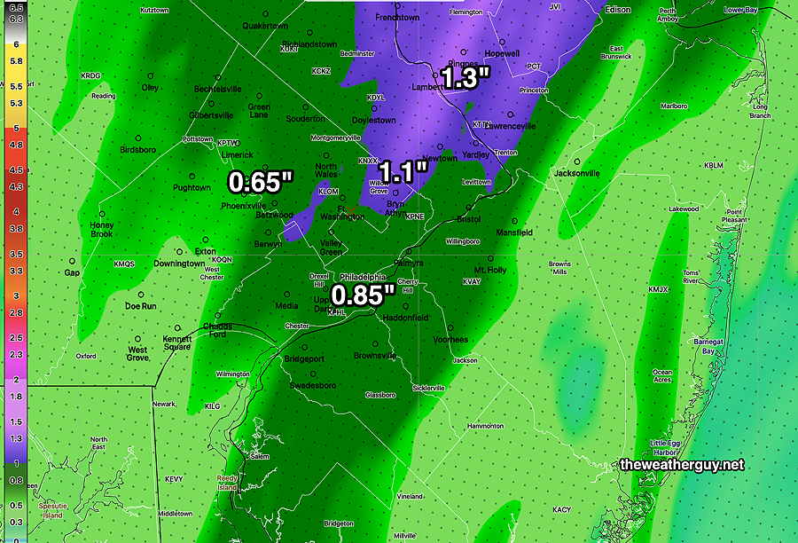
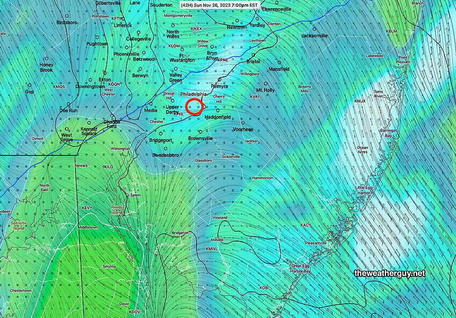
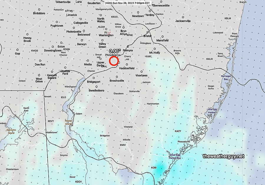
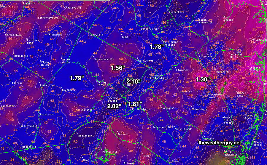
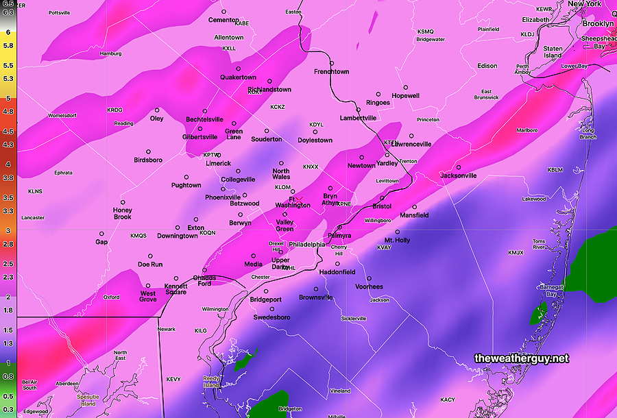
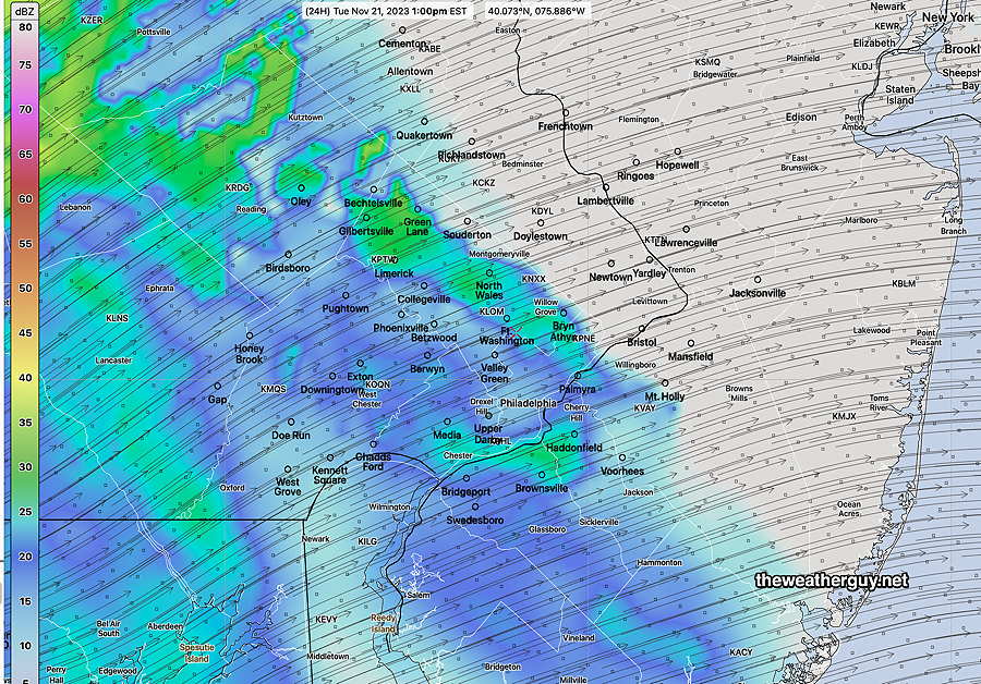
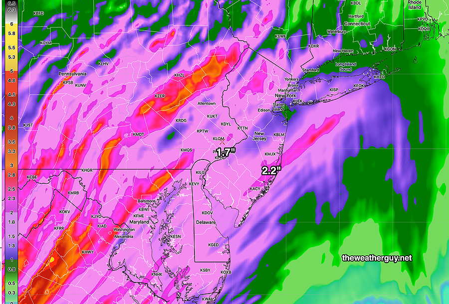
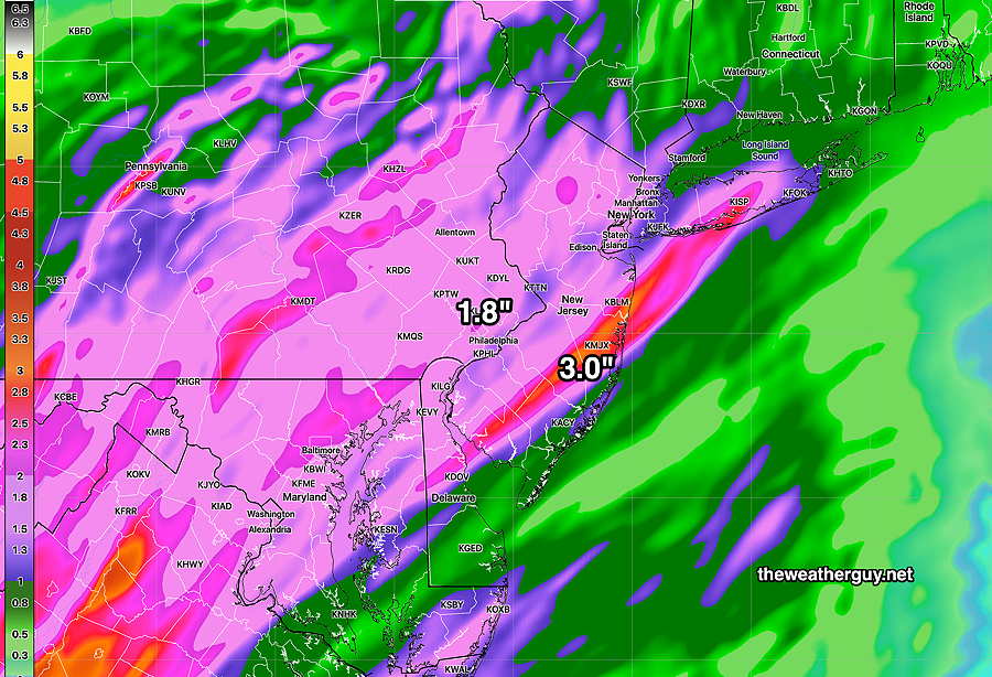
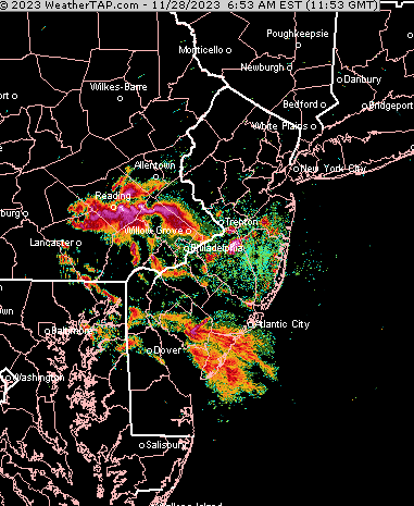
Update Mon 11/27 @ 9:26 AM — Sunday’s models finally got it right for the heavy rainfall we received—

MRMS rain guage – radar based estimate of rainfall received. Color shading is in inches. Line contours are in mm (25.4 mm= 1 inch) (Click on image for a larger view.)

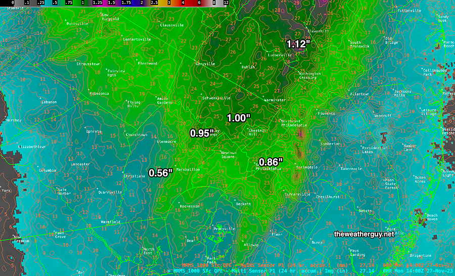
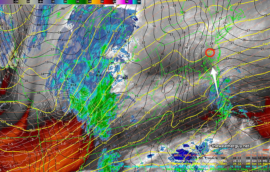
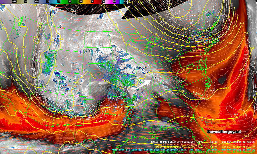
Current Water Vapor image Monday morning—

Current satellite water vapor image with superimposed RAP model 500-1000 mb thickness lines (yellow contours), Mean Sea Level Pressure isobars (black contours) potential vorticity (fine white contours) with superimposed MRMS RADAR. Lake effect snows developing with the abrupt change in temperature. Cold air will move in from Canada. (Click on image for a larger view.)

Monday will become windy and considerably colder after noontime. Typically, the high temperature is reached daily around 2-3 PM standard time. Today, our high temperature will be reached around 11 AM -12 PM and will drop from there. An abrupt increase in winds is expected as well.

Tuesday is looking quite cold and very windy.


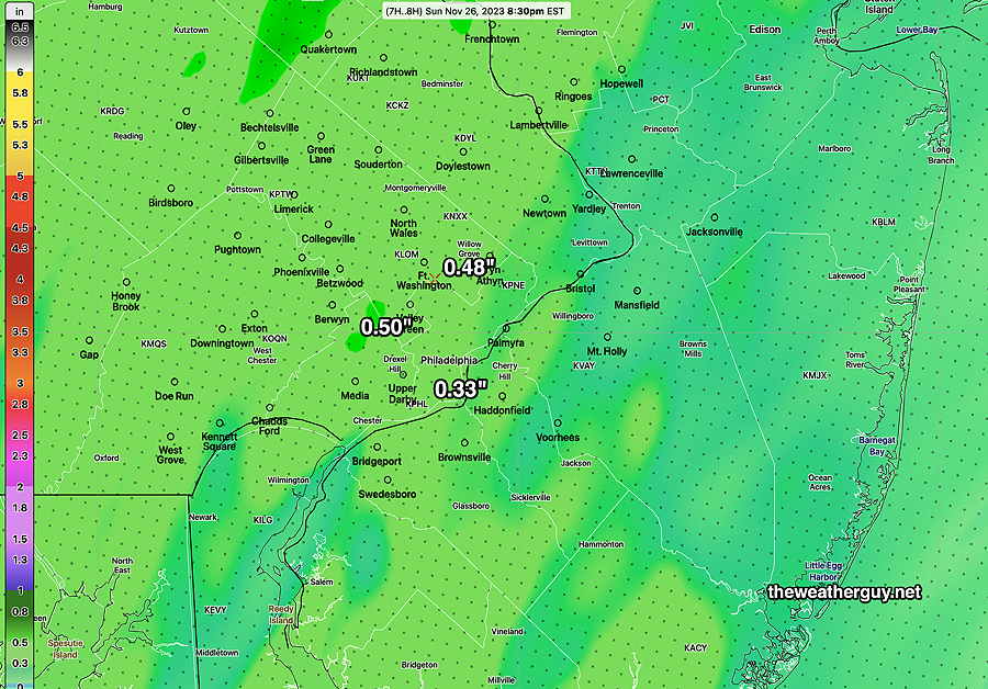
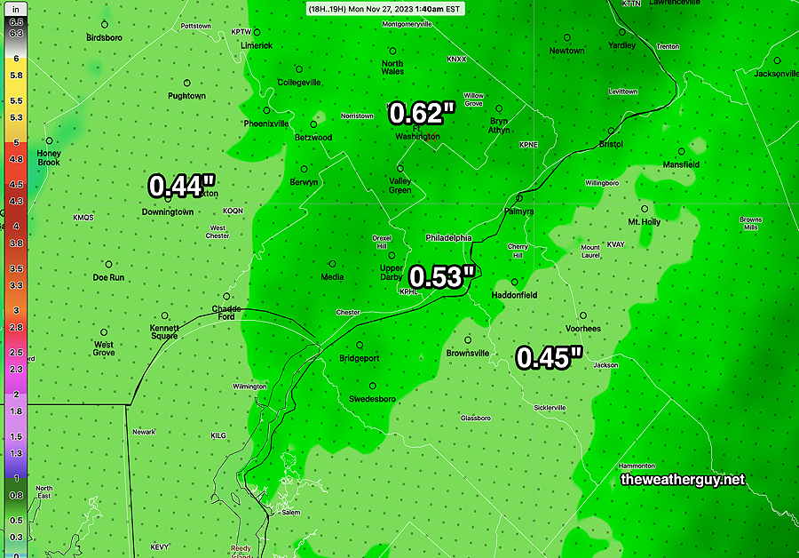
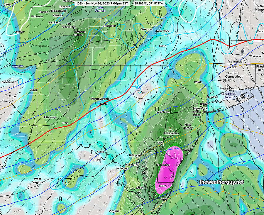
Previously Posted Sun 9:56 PM —

Following this heavy rainstorm Sunday night (totally missed by most models 24 hours ago with the notable exception of the HRDPS -which I ignored), a cold front will move through a few hours before daybreak Monday.

We may see some periods of instability cloudiness on Monday and an increase in winds/gusts.

The cold air will move in during Monday afternoon and from Monday night through early Thursday, it will be quite cold here with highs in the upper 30s to 40 Tuesday and Wednesday.

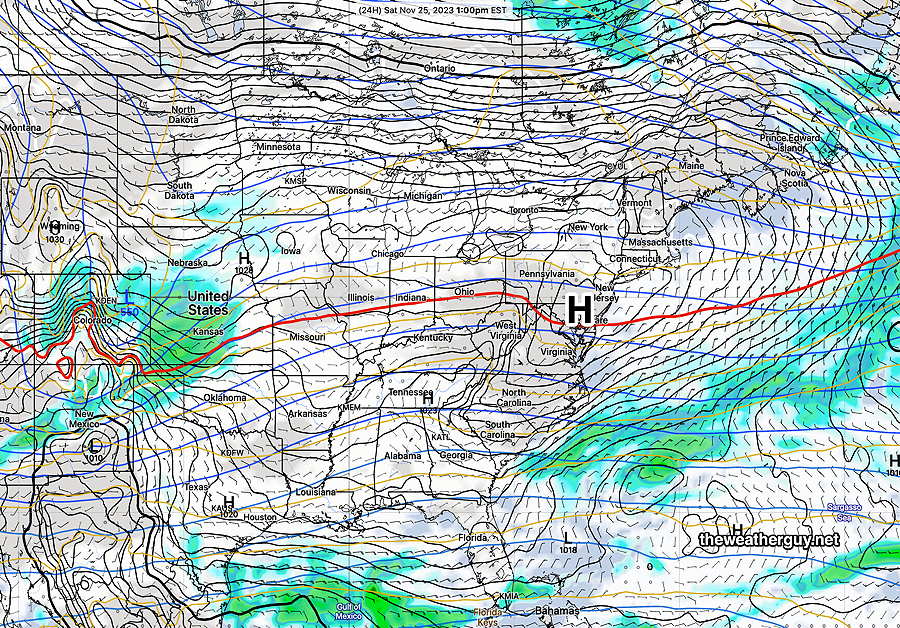
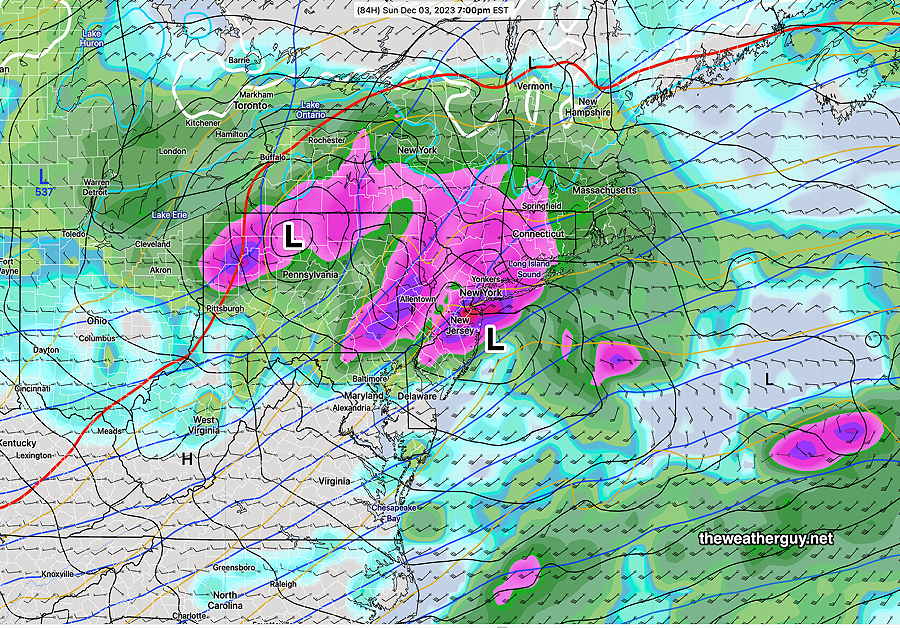
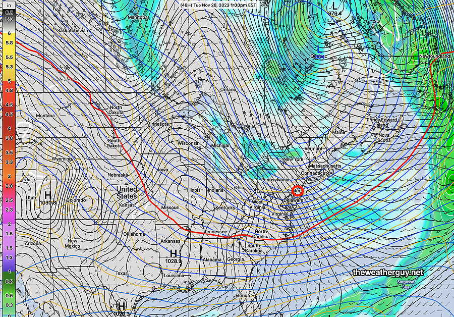
Here’s the NAEFS forecast for Tuesday, showing high pressure over our area—

Today’s 18z NAEFS forecast for Tuesday 1 PM, showing high pressure over our area and the red 540 thickness line far to our south, indicating cold air and the dip in the jet flow. (Click on image for a larger view.)

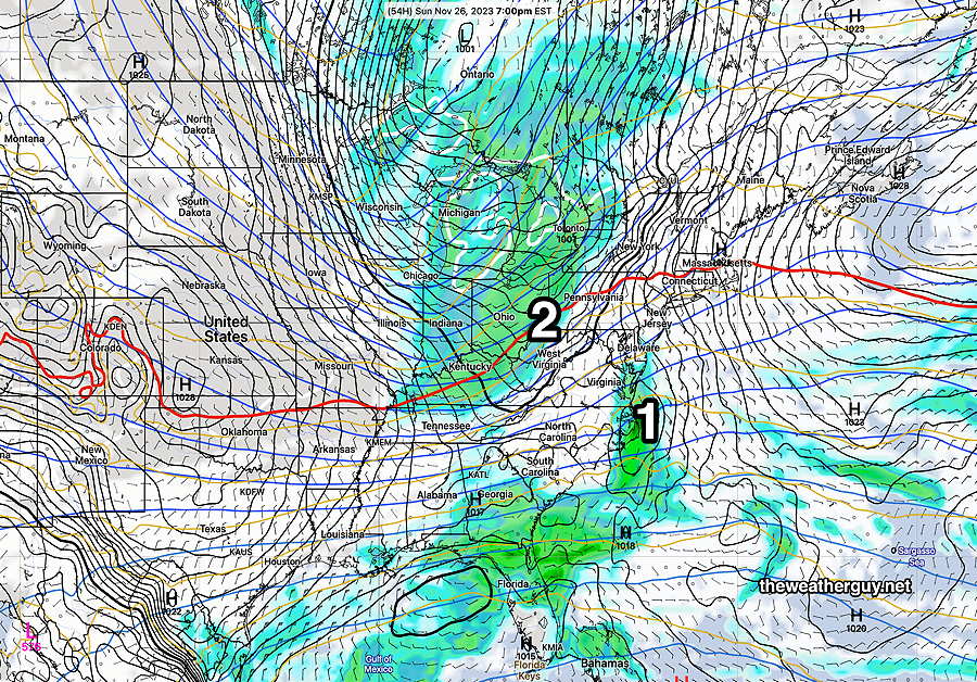
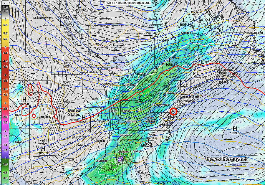
By Friday, the upper trough from Tuesday will have transformed into a ridge, indicating warmer air returning. Low pressure and another front will bring rain later Friday—

18z NAEFS forecast for Friday 1 PM showing the upper level ridge, as captured by the shape and position of the red 540 thickness line. (Click on image for a larger view.)

So a dry, cold week on tap. Rather windy at times as well. Rain returns later on Friday.


WEEKEND WEATHER FORECAST

#Phillywx #Philadelphia #weather #PAwx

A very different rain storm than had been forecast two days ago.

Update Sun 11/26 @ 3:58 PM — The latest HRRR and NAM-NEST have rainfall amounts during tonight’s Eagles game significantly higher than had been forecast—

18z HRRR total rainfall through 8:30 PM (Click on image for a larger view.)

Here’s the total rainfall forecast through midnight—

This afternoon’s 18z HRRR total rainfall forecast for this evening. (Click on image for a larger view.)
Sun 2:17 PM Forecast Review — It appears that light showers have moved in from the south even an hour earlier than forecast.
Sunday Forecast Update

Update Sun 11/26 @ 9:24 AM — No change from the forecast update last night. An earlier start of the rain, and much heavier than previous model guidance had forecast. A faster system that will leave around or before midnight, but not after almost 0.75″ of rain falling!

Current Radar/Water Vapor at 9:15 AM—

Current satellite water vapor image with superimposed RAP model 500-1000 mb thickness lines (yellow), Mean Sea Level Pressure isobars (black contours) potential vorticity (fine white contours) with superimposed MRMS RADAR. (Click on image for a larger view.)

Here’s my original forecast from Friday evening:

Cloudy early, the some sun towards noon, becoming cloudy again during the afternoon. Light rain moves in about 6-8 PM. Breezy.

High temperature 49º ( NBM model— location Blue Bell, PA)
High temperature 51º ( NBM model— location Philadelphia, PA)
uncertainty is about average with a ± 2.0º sd

Here’s my latest forecast for today:

Cloudy early, then some sun towards late morning, becoming cloudy again just around noon. Light rain moves in between 3-4 PM and becomes heavier during the second half of the Eagles game. Rain departs about 11 PM to midnight.

High temperature 49º ( NBM model— location Blue Bell, PA)
High temperature 52º ( NBM model— location Philadelphia, PA)
uncertainty is about average with a ± 1.8º sd

Winds breezy and gusty up to 25 mph around 7 PM

Here’s the latest, NBM 12z forecast total rainfall by midnight—

12z NBM with accumulated rainfall by midnight tonight. Heavier rain further north and east of the city into NJ. (Click on image for a larger view.)

Sunday Forecast Update

Update Sat 11/25 11:18 PM — As mentioned this morning, there was a shift in the forecast towards an earlier start of the rain but the GFS became what was possibly an outlier. Well, this afternoon, and this evening, the models converged on an earlier start with some light rain as early as 3-4 PM. The HRDPS has been the most consistent and it’s forecasting some significant rain by the Eagles second half.


Rain likely after the Eagles Game Sunday

Update Sat 11/25 @ 11:12 AM — A quick update. Our high resolution models have joined the Canadian and European ECMWF with an earlier onset of the rain, 5 PM to 7 PM Sunday, and somewhat heavier. This morning’s GFS, just available, has moved in the opposite direction: a more eastward track of the storm, a later start to the rain, and less overall rainfall for Philadelphia. So high uncertainty.


Update Sat 11/25 @ 09:17 AM

There remains timing issues with the onset of the light rain late Sunday afternoon/evening. The ECMWF and Canadian HRDPS continue with an earlier onset of the light rain, about 4-7 PM. Our NOAA models (GFS, HRRR, HREF) show a later start, after 8 PM. I’m leaning towards a later start, but this forecast is lower than average confidence.

Either way, any rainfall during the game should be light, on the order of 0.01″ – 0.03″ inches or so.

The HRDPS has the most rain during the game 0.03″ at 7 PM—

06z Canadian HRDPS shows accumulated rainfall of 0.03″ at 7 PM Sunday (Click on image for a larger view.)

Our NOAA HREF shows 0.00″ at 7 PM —

06z HREF accumulated rain forecast for 7 PM Sunday (Click on image for a larger view.)

I’ll provide further updates later.


Previously Posted Fri 8:02 PM —

Following a weak cold front that moved through today, colder weather is expected. High pressure directly over us will provide mostly sunny skies on Saturday—

Today’s 18z GFS forecast for Saturday. Sunny skies with high pressure directly overhead. The red 540 thickness line is to our south, indicating colder weather. (Click on image for a larger view.)

Low pressure will approach from the south on Sunday and very light rain with this system will move in about 6-8 PM Sunday. The rain will become somewhat heavier after midnight, but only about 0.25 inches of rain are expected, somewhat heavier north and east into NJ —

Today’s 18z GFS shows light rain from a coastal system (1) moving up the coast and merging with the rain associated with a cold front (2) Sunday night into Monday morning. (Click on image for a larger view.)

Colder weather expected next week.

Saturday

Mostly sunny and colder. Light winds.

High temperature 41º ( NBM model— location Blue Bell, PA)
High temperature 43º ( NBM model— location Philadelphia, PA)
uncertainty is low with a ± 1.3º sd

Sunday

Cloudy early, the some sun towards noon, becoming cloudy again during the afternoon. Light rain moves in about 6-8 PM. Breezy.

High temperature 49º ( NBM model— location Blue Bell, PA)
High temperature 51º ( NBM model— location Philadelphia, PA)
uncertainty is about average with a ± 2.0º sd


THIS WEEK’S WEATHER

#Phillywx #Philadelphia #weather #PAwx

Friday Update

Update Thu 11/23 9:38 PM — A weak cold front will move through mid day Friday with a few hours of mid and high level cloudiness.

Details for the weekend tomorrow. Currently, it appears that the showers will arrive Sunday evening between 6 and 8 PM. Initially, they’ll be quite light.


Possible Weekend Forecast Change

Updated Wed 11/22 @ 7:58 PM — The next few days are expected to be mostly sunny, but there’s been a shift in the forecast for Sunday.

Some background first:
Earlier this week, a coastal storm was expected to form in the Friday to Saturday time frame. Model runs by Tuesday had the storm moving out to sea, well to our south, not affecting our weather.

Today’s GEFS, NAEFS, ECMWF, ICON and GFS now have this coastal system moving up the coast late on Sunday and interacting with an approaching cold front late Sunday afternoon into evening, possibly during the Eagles game.

The timing varies, with the ECMWF having some rain moving in during the mid afternoon Sunday, while the GFS has the rain developing after 8 PM or so.

Here’s this morning’s ECMWF forecast for 7 PM—

Today’s 12 z ECMWF forecast 3 hour accumulated rain forecast for Sunday at 7 PM (Click on image for a larger view.)

There are currently timing differences, with the GFS slower and later with the rain here. This system has been tough to nail down and I would expect further changes in the forecast.


Wed 9:49 AM Forecast Review — We had the heavy rain as forecast, although totals were somewhat overdone by the HRRR (but more accurate with the development version of the RRFS). The banding of heavier rain set up close to the forecast with a strip of 2″ rains right through the immediate Philadelphia area.

Here’s the MRMS total rainfall for the past 24 hours—

MRMS rain guage – radar based estimate of rainfall received. Color shading is in inches. Line contours are in mm (25.4 mm= 1 inch) (Click on image for a larger view.)

Here’s yesterday’s 12z RRFS—

Yesterday’s 12z RRFS shows the 2.1″ band right through Philadelphia. Not bad! Note that my color coding is very different than the MRMS /AWIPS. (Click on image for a larger view.)

As for Wednesday, several models continue with the idea of mostly cloudy, but a few breaks of sunshine can’t be ruled out. It will be mild. There’s the possibility of a few widely scattered sprinkles about 8 PM this evening.

Sunny for Thanksgiving Day and into the weekend. The trend is for lower temperatures here into the next week or so.


Wednesday Outlook

Updated Tue 11/21 @ 8:36 PM — The rain moved in on schedule and the heaviest rain is expected between 11 PM and 2 AM tonight. Winds are also expected to peak in the same time frame.

Here’s the current situation at 8:30 PM—

Current satellite water vapor image with superimposed RAP model 500-1000 mb thickness lines (yellow), Mean Sea Level Pressure isobars (black contours) potential vorticity (fine white contours) with superimposed MRMS RADAR. The heaviest rain is still to our south and will move in later this evening. (Click on image for a larger view.)

The rain ends about 4-5 AM Wednesday and skies will be cloudy early morning. There will likely be some brief periods of sunshine early to mid morning, but instability cloudiness will be with us for most of the day Wednesday. There’s even a slight chance of a widely scattered sprinkle.

It will be very mild! High 59º-61º, but somewhat windy.

Thanksgiving Day will be sunny, but cooler. high 51º-53º


Tuesday Rain Update

Updated Mon 11/20 @ 5:30 PM — We’re back to an earlier start of the rain on Tuesday, with the GFS, HRRR and NBM all shows rain moving in from the southwest, as early as 12:30 PM in Chester County and moving into the rest of our area after 1-2 PM.

1 PM HRRR simulated radar forecast—

18z HRRR simulated radar forecast 1 PM Tuesday afternoon. (Click on image for a larger view.)

The latest HRRR cranks out some impressive rainfall and wind gusts later Tuesday approaching 40 mph —

18z HRRR total rainfall through Wednesday 7AM . (Click on image for a larger view.)

It looks like the rain will end about daybreak Wednesday. We may see sunshine as early as 9-10 AM. but instability cloudiness will quickly move in with considerable cloudiness by afternoon.


Tuesday Rain Update

Updated Mon 11/20 @ 10:02 AM — There has been some uncertainty with the onset of the rain in Philadelphia on Tuesday. This morning’s trend is towards a somewhat later start, about 3-4 PM, earlier in southern Chester county. The latest 12z NBM (which tends to lag when showing changes) is still showing a 1-2 PM start.

The total rainfall forecast based on this morning’s 12z HRRR—

12z HRRR total rainfall through 7 AM Wednesday. (Click on image for a larger view.)

I’ve been playing with the still experimental RRFS and it shows similar totals, although placement is different—

Today’s 06z RRFS TESTBED model totals. (Click on image for a larger view.)

The big story will be the WIND around midnight Tuesday into early Wednesday morning. Gusts are being forecast to 40 mph! Combined, with heavy rain, it will be an interesting 12 hours.


Previously Posted Sun 8:38 PM —

Low pressure is developing to our southwest and will move into our area Tuesday afternoon with rain. The rain may be heavy Tuesday night.

Current satellite water vapor image (Sunday evening) with superimposed RAP model 500-1000 mb thickness lines (yellow), jet level wind streamlines (orange contour-arrows) potential vorticity (fine white contours) and superimposed MRMS radar. The system in the middle of the country will move towards us and the rain will start Tuesday afternoon. (Click on image for a larger view.)

There has been some spread in the timing onset of the rain on Tuesday. Earlier forecasts were going with 4 PM. Recent models have some light rain as early as noon. Others delay the rain until 1-2 PM. The 1-2 PM start looks best at this time.

Rainfall totals are expected to be moderate to heavy with totals 1.6 +”. Here’s the latest NBM total accumulated rainfall forecast—

Today’s 18z NBM model accumulated rainfall Tuesday through Wednesday. (Click on image for a larger view.)

The heavy rainfall forecast has been consistently high. (We really need the rain!)

The speed of the system is still somewhat uncertain. The general consensus is that the rain ends Wednesday morning but clouds linger for much of the day. It will be quite windy.

Thursday, Thanksgiving Day, looks sunny but chilly. Highs upper 40s to low 50s.

There’s another chance of rain in the Friday through late Saturday time frame due to a coastal storm. Much uncertainty with the details right now.