THIS WEEK’S WEATHER

#Philadelphia #weather #PAwx

Quick Update

Updated Fri 10/13 @ 12:00 PM — This morning’s GFS just available shows an earlier start time for the rain Saturday, different than last night’s models. The GFS shows accumulating rain as early as 8-10 AM Saturday moving west to east. (I tend to like the GFS timing with these things, but it’s not fail-proof.)

Today’s 12z GFS simulated radar and accumulated rain contours (green contours 0.01″ intervals.) forecast for 10 AM Saturday. (Click on image for a larger view.)

Update Fri 10/13 9:26 AM — Sunny and cooler Friday.

Model trends show a later start to the heavier rains Saturday. A late morning quick sprinkle can’t be ruled out but the main area of rain moves in about 1-3 PM and the heaviest rain during the evening and nighttime hours. Rainfall totals may be less than previously forecast in the immediate Philadelphia area, about 1” with higher amounts near the Jersey Shore and northwest of Reading. Windy at night.

Rain ends Sunday morning. Breaks of sun in some (but not all) areas Sunday afternoon. Windy.

I’ll update later today.


Friday through Sunday

Update Thu 10/12 10:25 PM — Friday looks to be sunny and cooler. Rain starts later on Saturday, moving in from west to east, between 11AM and 2 PM. A faster moving system will likely clear out by Sunday afternoon, with rainfall totals somewhat less than posted earlier.


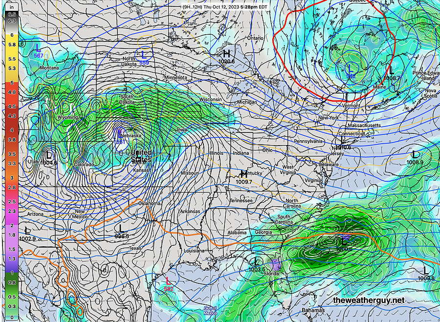
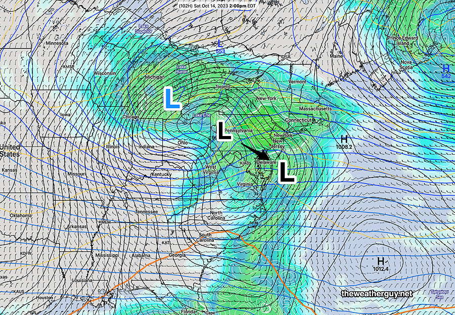
Updated Thu 10/12 @ 6:04 PM —A large storm will develop as a secondary low forms off of the Delaware coast later Saturday.

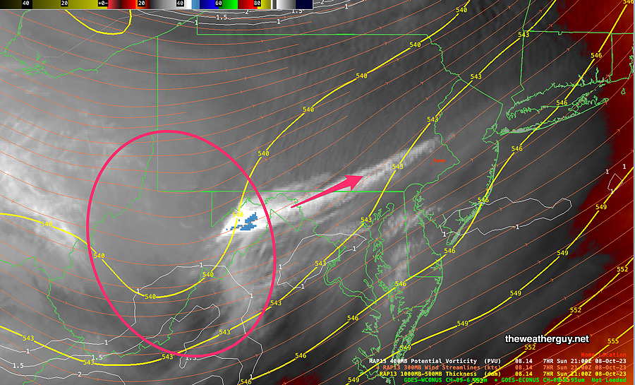
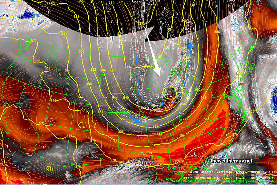
Currently, water vapor imagery shows the seeds of the storm to affect us Saturday into early Sunday—

Water Vapor image 5:20 PM Thursday with superimposed RAP ), potential vorticity (fine white contours) and superimposed MRMS radar. Low pressure in Nebraska will move east and a secondary coastal low will form Saturday. (Click on image for a larger view.)

The above image corresponds to this NAEFS model map—

Today’s NAEFS map for the current time (5:20 PM) Thursday. (Click on image for a larger view.)

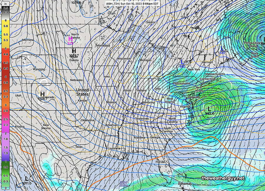
By late Saturday into Sunday morning , a strong coastal storm will have formed—

NAEFS forecast for 5 AM Sunday morning showing the coastal storm (Click on image for a larger view.)

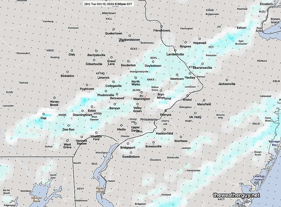
Rain begins mid morning on Saturday and becomes heavier by the afternoon.

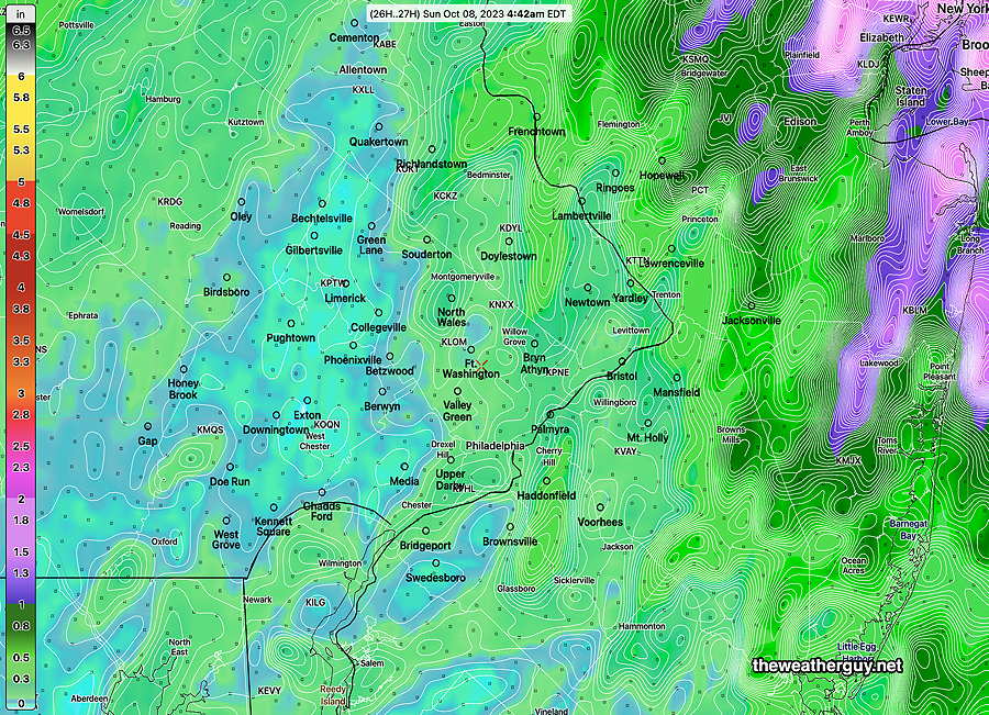
Total rainfall, based on the current NBM is 1.2″ to -1.4″—

NBM total rainfall through Sunday ranges from 1.2-1.4″ in our area. It should be noted that the ensemble forecasts and the ECMWF show lower totals, on the order of 0.6″ to 1″.

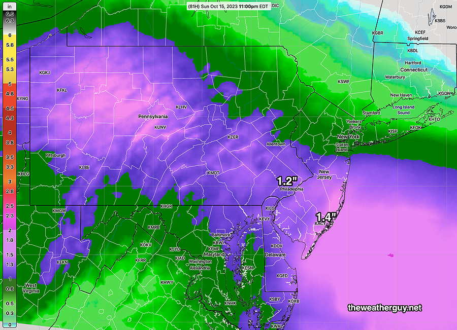
Rain ends sometime Sunday morning. but clouds linger with windy conditions. This is a change from previous model forecasts, which had showers lingering later.

The latest GFS shows some sun Sunday afternoon.

An interesting storm. Stay tuned for updates.

Thursday through Sunday

Updated Wed 10/11 @ 8:54 PM — Go Phillies! OK, back to the weather.

The models have us being in fair, dry weather Thursday through Friday, and the latest models have the heavy rain starting somewhat later, now during the morning hours Saturday instead of midnight Friday. It may clear later Sunday, but right now I wouldn’t bet on it.

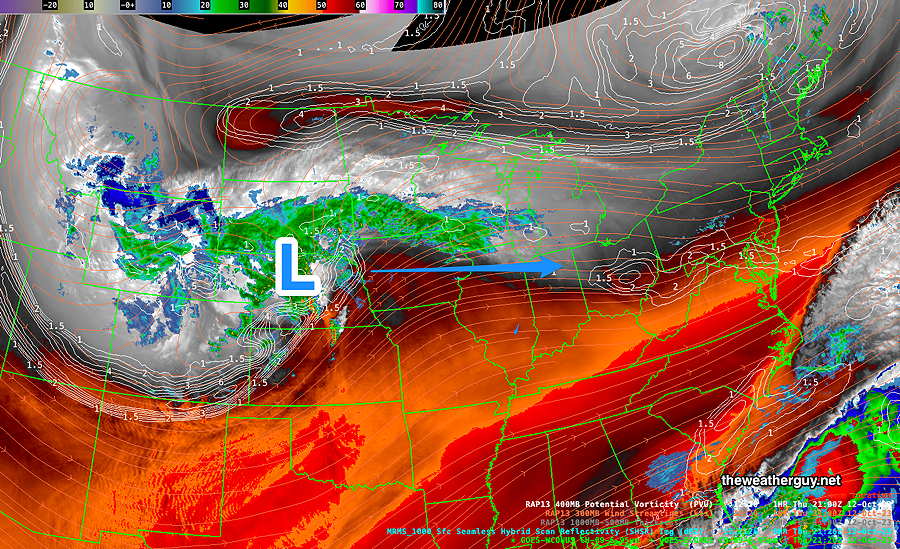
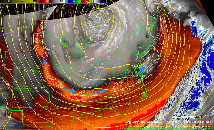
Of interest is the current water vapor imagery which shows moisture moving up from the south along with some rain developing in the central US, ahead of the system expected on Saturday.

Current Water Vapor image with superimposed RAP model thickness lines (yellow), potential vorticity (fine white contours) and superimposed MRMS radar. Of interest is the moisture moving up from the south along with the area of disturbance ( red?) . The models have this being suppressed to our north and south, but you wouldn’t know that from this image. (Click on image for a larger view.)

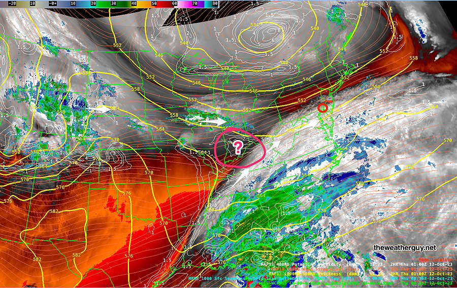
It will be interesting if any cloudiness develops early afternoon Thursday from this questionable area. The GFS suggests this possibility, the NBM not so much. The Canadian HRDPS, not at all.

I’ve learned to never second guess the models, so at this time, some increased cloudiness on Thursday is just a thought experiment.


Wednesday and Beyond

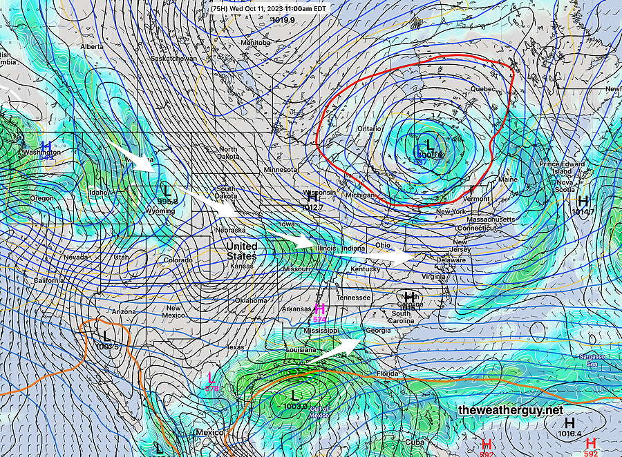
Updated Tue 10/10 @ 5:21 PM — The closed, stationary upper low over Canada continues to rotate disturbances, but the models are forecasting those disturbance to have a trajectory further to our north Wednesday thorough Thursday.

As a result Wednesday and Thursday will have more sunshine than clouds and temperatures are expected to moderate with highs approaching 70º by Thursday—

NBM Model Temperatures/Dew points for Blue Bell, PA (Click on image for a larger view.)

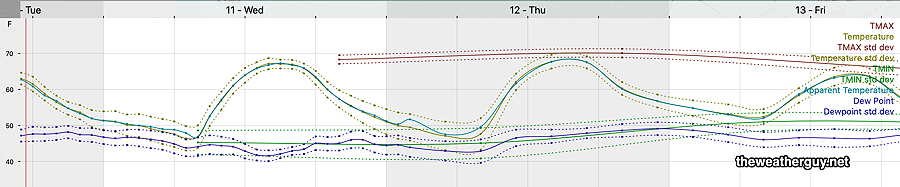
It should be noted that the high temperatures start to decrease a bit on Friday. That’s due to increasing cloudiness ahead of a rather robust weather system that will bring rain Saturday and much of Sunday.

The NAEFS and GEFS has been forecasting a significant low pressure system to move in and re-develop a secondary surface low along the coast over the weekend Some heavy rain is possible with this system—

NAEFS forecast for Saturday 2 PM. Upper low (blue L) with surface low (black L) will transfer energy to a coastal secondary low. Heavy rain possible. (Click on image for a larger view.)

Tuesday Update

Updated Tue 10/10 @ 10:11 AM — Yesterday’s forecast of “a low chance of widely scattered showers” for today has moved into a more likely event.

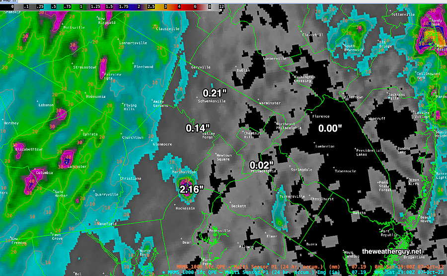
The latest NBM shows very light showers moving through from now into mid afternoon—

Today’s 12z NBM total rain accumulation for today, Tuesday. (amounts less than 0.02″) The NBM still shows some breaks of sun during the day as well. (Click on image for a larger view.)

Tuesday

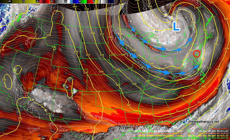
Updated Mon 10/09 @ 9:32 PM — Showers are moving through this evening as forecast, the result of a disturbance rotating around the upper low in Canada. Weaker disturbances will move through Tuesday, for a mix of sunshine and clouds. A low chance of a widely scattered shower Tuesday afternoon. About 2-3º warmer than Monday.

Current water vapor image shows the current upper air situation—

Water Vapor image with superimposed thickness values (yellow) and RAP potential vorticity (white fine contours/blue arrows) show the area of disturbances causing the clouds and showers. (Click on image for a larger view.)

Wednesday looks good.

Unfortunately, the weekend still looks quite rainy, but too soon to be sure.


Previously Posted Sun 8:21 PM —

An upper air low will close off and rotate disturbances around it, as high pressure builds in by late Tuesday into Wednesday.

Water Vapor Image with RAP model thickness and potential vorticity. Upper level low (L- Blue) will become almost stationary for much of the week. Some disturbances will develop and rotate around the low affecting our weather Monday night. .

Monday will be chilly and sunny, but instability cloudiness will develop mid afternoon (like today) as a disturbance moves in. Some showers possible Monday night, clearing on Tuesday.

By Wednesday the low is “closed” and remains stationary but high pressure builds in. Meanwhile, next weekend’s weather is brewing in the Pacific northwest—

NAEFS forecast for Wednesday morning shows closed low, with high pressure building in. The white arrows show disturbances originating in the Pacific that will cross the country and potentially give us a rainy weekend.

WEEKEND WEATHER FORECAST

#Phillywx #Philadelphia #weather

Sunday Update

Updated Sun 10/08 @ 11:34 AM — My forecast already included clouds and isolated sprinkles today. It appears that a significant wave has developed to our southwest and we may have considerably more cloudiness than forecast at times. Breaks of sun possible and still a chance of isolated sprinkles as well.

Sunday morning WV image with superimposed RAP model thickness lines and potential vorticity contours (white). You can see why they call it a “wave” here. (Click on image for a larger view.)

Sunday

Update Sat 10/07 9:47 PM —

Sunny in the early morning. Periods of clouds and sun in the afternoon. There’s a chance of isolated instability sprinkles in the mid to late afternoon, especially north and west of the city. Windy.

High temperature 60º ( NBM model— location Blue Bell, PA)
High temperature 62º ( NBM model— location Philadelphia, PA)


Sat 3:57 PM Forecast Review — Yes, the model forecasts have been a bust today. More specifically, the rain totals have been a mere fraction of what was forecast, even this morning. Here’s this morning’s NBM rainfall forecast—
Today’s 06z NBM rainfall forecast for Saturday. (Click on image for a larger view.)

Here’s the current estimated actual measured rainfall that occurred over the past 24 hours based on radar and rain gauges (MRMS estimate) —

MRMS based total 24 hour rainfall period ending 3 PM. based on combined radar with actual rain-gauge measurements (Click on image for a larger view.). (Click on image for a larger view.)

The model forecast guidance usually impresses me. Not over the past three days. As I’ve mentioned over the years, the presence of a tropical system nearby seems to affect the accuracy of the models. Not sure why that is, and it’s just an observation based on my many years doing this stuff.

I had mentioned earlier this morning that the HRDPS did well.

HRDPS (06z) forecast for total rain Saturday. (Click on image for a larger view.)

Well, not perfect by any means, but the rainfall totals were more in line with what we received and it even placed the 0.00″ area fairly close to where no rain was received. Yet areas in NJ received no rain, despite some significant rain being forecast.

Saturday Update II

Updated Sat 10/07 @ 10:00 AM — So, which model has done the best with this system? It appears the Canadian HRDPS has done very well. It even shows the break of sunshine we had over the past 3 hours.—

HRDPS cloud cover at 10 AM. (black/grey is cloud cover). (Click on image for a larger view.)

While we’re on an HRDPS roll, the model has very light total rainfall for much of our area—

06z HRDPS total rainfall through 2 AM Sunday morning. (Click on image for a larger view.)

Updated Sat 10/07 @ 9:33 AM — Here’s the latest WV/Radar image—

WV MRMS radar with RAP model “most unstable” CAPE (yellow contours) . While the front has moved through, the rain/showers with this system is sill to our west and will be approaching. Model forecasts suggest most of the rain will be to our northwest. (Click on image for a larger view.)
Saturday Update

Updated Sat 10/07 @ 9:16 AM — The model forecasts over the past two days haven’t been that stellar and today’s forecast continues that trend. The front has just moved through the immediate Philadelphia area, based on wind shifts in the RTMA

RTMA wind shifts at 9 AM. (The RTMA model is run every 15 minutes with a 15 minute computational time delay.) Colors show wind gusts entering western suburbs with streamlines showing the wind shift to the northwest. (Click on image for a larger view.)

Additional showers expected, but much of the heavier rain is moving off to the northwest.


Previously Posted Fri 5:52 PM —

An upper level trough will drive a cold front through Friday night into Saturday morning—

Water vapor image Friday afternoon shows upper and mid level of the atmosphere. (FYI, It doesn’t show clouds.) Areas of vorticity encircle the upper trough. This trough is forecast to close off and become a ‘closed upper low’ around Quebec province. Disturbances (areas of vorticity) rotating around this low (blue arrows, white contours) will set off cloudiness at times this weekend. (Click on image for a larger view.)

Saturday

The front comes through the Philadelphia area around daybreak Saturday with showers and wind gusts. Areas of vorticity behind the front will set off additional showers into the afternoon. There may be a quick break of sun, but mostly cloudy conditions with rain showers expected. It appears that one of those disturbances moves through early afternoon, with some rain showers. Unsettled is the term often used to describe this scenario. It will be windy. The rain may last until 4-5 PM, according to this afternoon’s models and skies will clear west to east.

(In a departure from recent forecasts, this afternoon’s HRRR shows some areas of heavy rain here Saturday. Right now, I’m seeing it as an aberration. I’m inclined to lean towards the HRDPS model, which has an area of heavy rain in northern Montgomery and Bucks counties Most other areas have lighter precip, less than 0.5 inches. )

High temperature 68º ( NBM model— location Blue Bell, PA)
High temperature 69º ( NBM model— location Philadelphia, PA) uncertainty ± 1.6º

Sunday

Continued windy. Sunny early in the morning. A considerable amount of instability cloudiness develops late morning into afternoon.

High temperature 60º ( NBM model— location Blue Bell, PA)
High temperature 61º ( NBM model— location Philadelphia, PA) uncertainty ± 1.7º

Winds

18z NBM wind meteogram for Blue Bell, PA (Click on image for a larger view.)