THIS WEEK’S WEATHER

#philly #weather #pawx #philadelphia #phillywx

Updates

Updated Sat 9/09 9:23 PM — Regular updates here to This Week’s Weather and Weekend Weather Forecast should resume next weekend…. Certainly in enough time for coverage of Hurricane Lee, which the ECMWF model is forecasting to possibly affect our region.


Thunderstorms Thursday Night

Updated Thu 09/07 @ 11:55 AM — A quick update. This morning’s models are suggesting that most of the showers and thunderstorms stay to our west tonight. We need the rain, but it looks like very little will make it into the immediate Philadelphia area tonight.


Updated Thu 09/07 @ 9:27 AM — A slowly advancing cold front will trigger thunderstorms tonight. Most of the stronger storms will affect far northwestern areas (Pottstown, Reading, Allentown) this later this evening.

Most (but not all models) have the storms moving through the immediate Philadelphia area and adjacent suburbs between midnight and 2 AM. Since these storms will be occurring well after the sun has set, surface level CAPE values will not be that high. Severe storms are NOT expected.

Rainfall amounts in our immediate area are not expected to be that high—

Today’s 06z HREF total rainfall for Thursday night. (Click on image for a larger view.)

Thursday Forecast

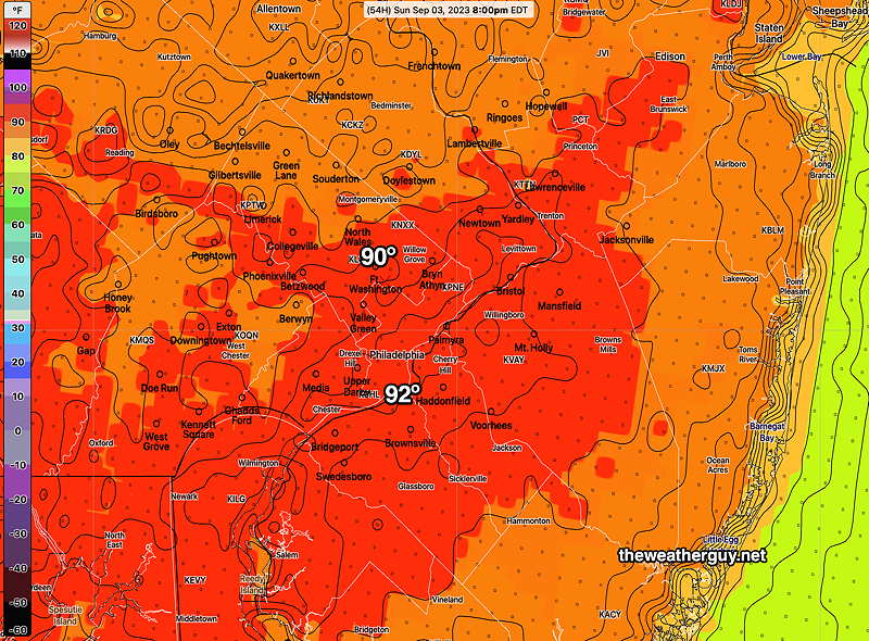
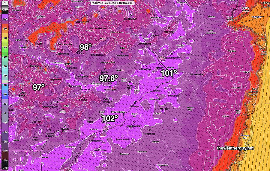
Updated Wed 09/06 @ 5:40 PM — A preliminary check of the RTMA shows that we ‘only’ hit 94º in Philadelphia, but areas just west of Atlantic City hit 96º. Dew points were in the mid to upper 60s during the high temperature period.

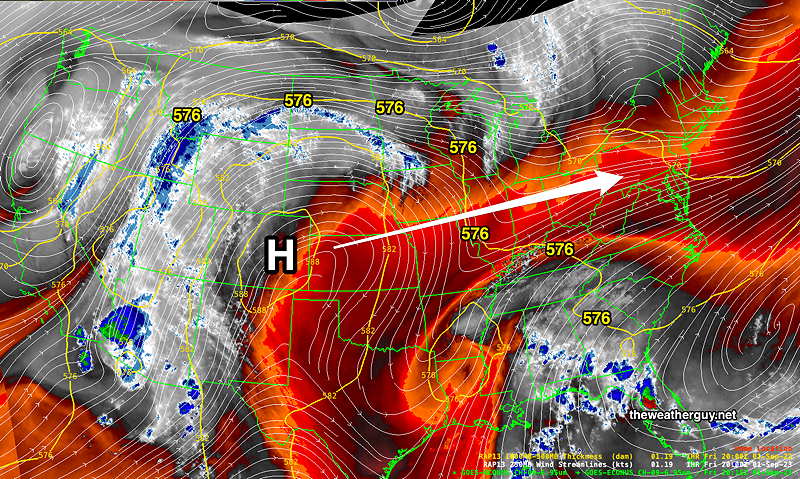
The hot air ‘dome’ is being squeezed by a very slowly moving push from the west and a stagnant low pressure system in the Atlantic (the non-tropical remains of what was Hurricane Idaila!)—

WV image Wednesday afternoon shows the ‘squeezed dome’ of hot air directly over us, delineated by the 576 thickness lines (yellow). (Click on image for a larger view.)

Thursday will likely be the hottest day, with temperatures truly hitting 96º+ and a much wider area around Philadelphia hitting heat indices of over 100º.

As the system in the Ohio tries to move eastward, it will be blocked somewhat but some slow progress is expected.

This means an eventual decrease in temperatures and an increasing likelihood of thunderstorms and rain from Thursday evening through at least Sunday.

Areas to our west and northwest will likely see thunderstorms Thursday night. They may not make it into Philadelphia or much further eastward.

From Friday through Sunday, more of our area will see showers and thunderstorms. Sunday looks to have the most widespread activity as the advancing front slows over our area.


Wednesday Forecast

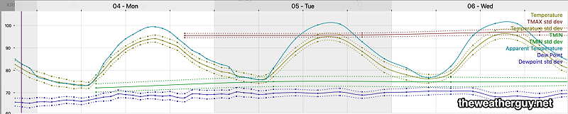
Updated Tue 09/05 @ 5:19 PM — High temperatures today (usually reached between 3:45 PM and 4:00 PM) were a degree or two lower than Monday. The increased dew points (69º -71º) more than made up for the marginally lower temperatures.

For Wednesday, temperatures are expected to move back to those reached on Monday, and the higher readings will be more widespread—

Today’s 18z NBM forecast high temperatures for Wednesday. (Click on image for a larger view.)

The dew points on Wednesday will be a bit higher as well. As a result, the heat indices will be quite hot in many areas—

18z NBM Apparent Temperature forecast (Heat Index) for Wednesday. (Click on image for a larger view.)

An approaching front will bring a good chance of thunderstorms Thursday evening and Friday evening.


Tuesday Forecast

Update Mon 9/04 10:10 PM — Tonight’s 00z NBM’s high temperatures for Tuesday are coming in a 1-2 degrees lower than Monday, but dew points look to be be higher. So heat indices may be the same or hotter. Another hot day!

Tonight’s 00z NBM “apparent temperature“ forecast (aka heat index) for Tuesday (Click on image for a larger view.)

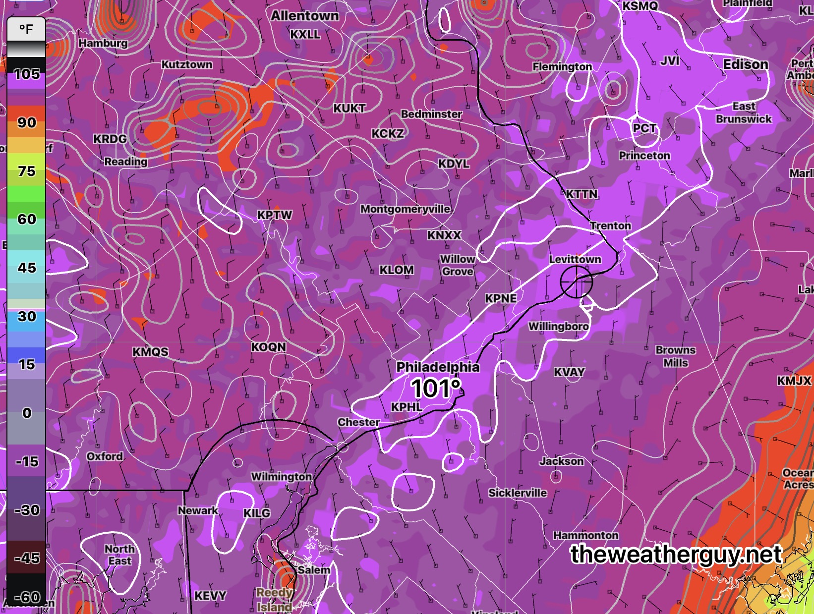
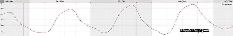
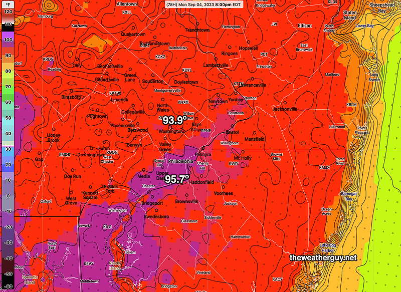
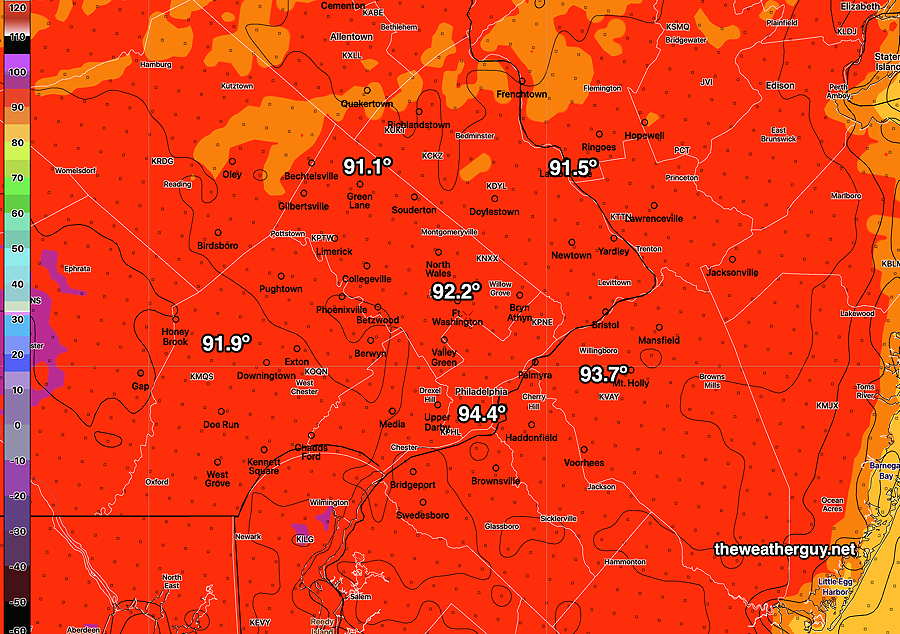
Updated Mon 09/04 @ 5:22 PM — Actual high temperatures on Monday—

1945z RTMA Temperature analysis at 3:45 PM Monday. Contours are 1º increments (Click on image for a larger view.)

It is very similar to last night’s NBM model forecast (but not this morning’s NBM) —

Last night’s 00z NBM forecast highs. While it is often the desire to ‘get the latest model’, due to model spin up issues, the most recent model forecast is often not the most accurate. (Click on image for a larger view.)

We can see that the HRRR (below) over forecast the high temperatures. When it comes to temperature forecasts, the NBM is often the best model.


Previously Posted Mon 10:10 AM —

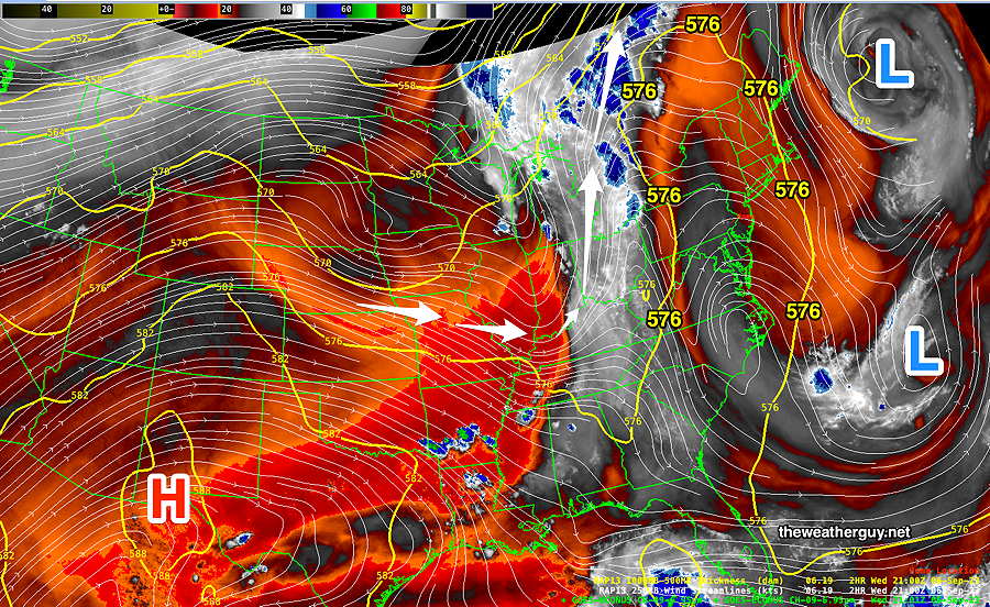
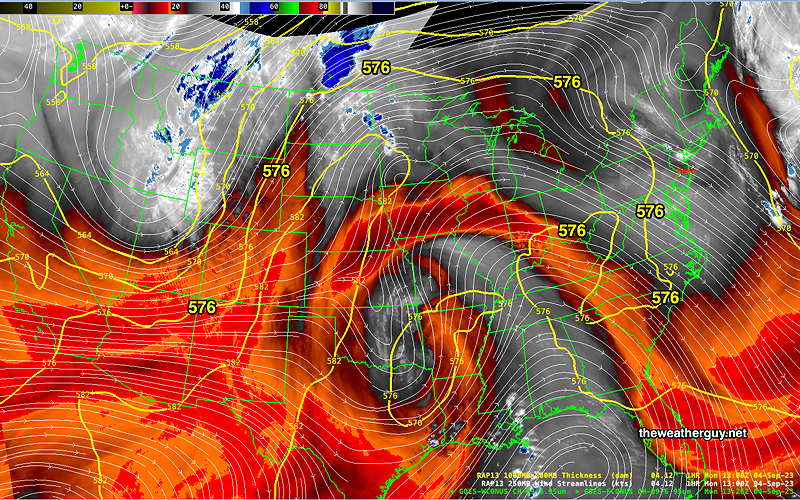
The large heat dome continues to nudge north and eastward towards us. The “576 thickness line” provides a clue into the three dimensional outline of this hot air mass—

This morning’s water vapor image (capturing the middle and upper atmosphere) and the RAP model 500-1000mb thickness line (mid level contour showing the outline of the very hot air at 576 decimeters) The hottest air is still to our west and south. (Click on image for a larger view.)

This morning’s NBM model’s high temperature forecast has moved down a degree or so from last night’s forecast highs temperatures.

Last night’s forecast—

This is last night’s NBM high temperature forecast. Today’s is similar, but without that patch of violet 95.6º High temperatures will be closer to 93º-95º today in our region.

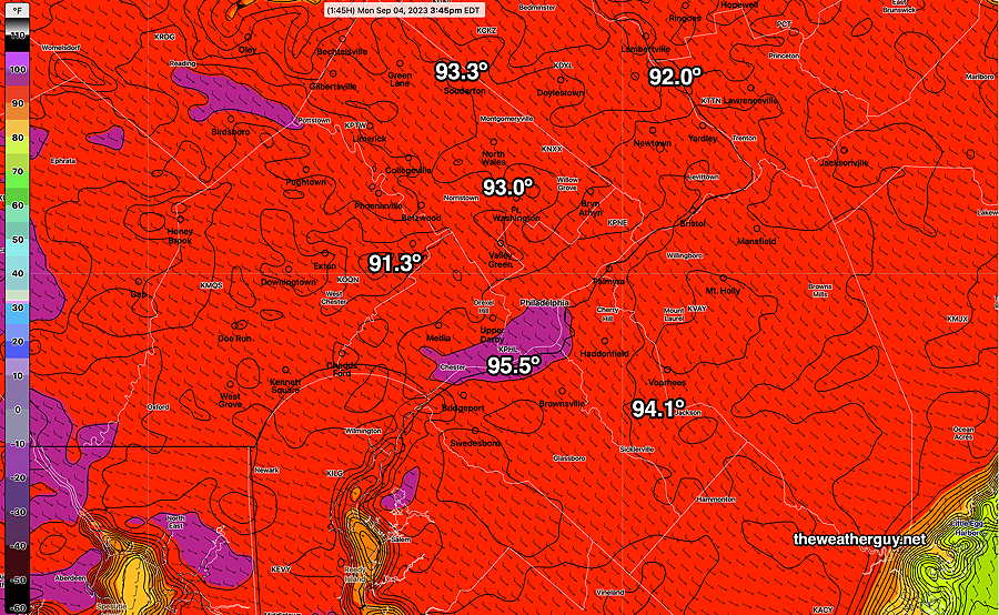
Today’s 12z NBM high temperature forecast—

Today’s 12z NBM High temperature forecast (Click on image for a larger view.)

As good as the NBM has been regarding temperature forecasts, it’s not forecasting the showers affecting northern parts of the Jersey Shore at this time—

Current radar with Satellite Channel 13. (Click on image for a larger view.)

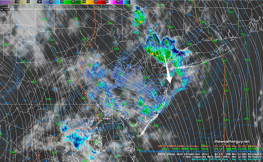
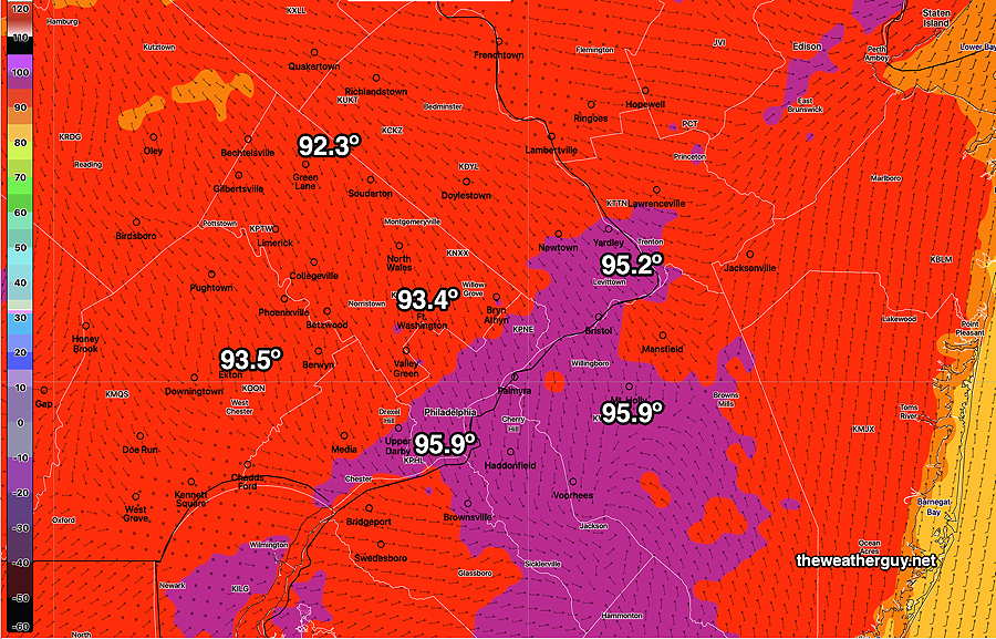
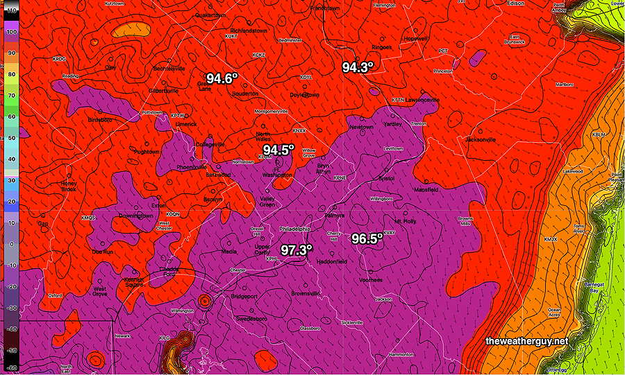
The latest HRRR does show these showers and it has a much hotter forecast for us today than the NBM—

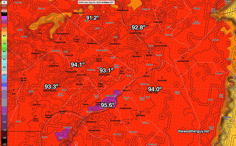
Here’s the latest HRRR forecast high temps for today—

Today’s 12z HRRR is forecasting much hotter high temperatures than the NBM (Click on image for a larger view.)

The NBM is my preferred model for high temperatures, but the NBM tends to be a lagging forecast by design.

We’ll see if the HRRR is forecasting too hot for today or whether its forecast represents a more up to date forecast.


WEEKEND WEATHER FORECAST

Philadelphia area Forecast including Labor Day

#weather #paweather #wx #pawx #philadelphia #phillywx

Monday- Heat Wave Continues

Updated Sun 09/03 @ 9:36 PM — High temperatures Sunday were 1º shy of last night’s NBM forecast (within the forecast standard deviation). The heat wave cranks up a notch on Monday.

The latest NBM forecast (00z) just became available and it’s consistent with past forecasts—

Tonight’s 00z NBM forecast high temperatures for Monday. Standard deviations (uncertainties) are about 1º again for Philadelphia and about 1.5º for the surrounding areas. (Click on image for a larger view.)

High temperatures are forecast to rise about 1º each day through Wednesday and possibly Thursday. Here’s the NBM forecast for KPHL—

NBM Forecast temperatures/dew points/heat indices (“apparent temperatures”) The apparent temperatures (over 100º) are likely too high because the NBM has been over-estimating the dew point temperatures. (Click on image for a larger view.)

Here’s the latest ECMWF forecast temperature meteogram for Philadelphia Airport—

ECMWF (18z run) through Wednesday. Temperatures Philadelphia Airport. A little lower temperature than the NBM forecast for Monday but much higher for Tuesday and Wednesday. (Click on image for a larger view.)

Update Sat 9/02 11:12 PM — The forecast remains on track for Sunday and Monday. I’m raising the expected high temperatures for Sunday. Monday’s forecast highs still look right.

Sunday

High temperature 91º ( NBM model— location Blue Bell, PA)
High temperature 93º ( NBM model— location Philadelphia, PA)

Monday

High temperature 94º ( NBM model— location Blue Bell, PA)
High temperature 96º ( NBM model— location Philadelphia, PA)


Previously Posted Fri 5:21 PM —


This is a fairly simple forecast and the details haven’t significantly changed over past days.

Following a delightful Saturday, the “heat dome” that has made the weather headlines this summer will expand eastward and northward, affecting our area starting Sunday.

This afternoon’s Satellite Water Vapor (which shows the upper atmosphere) with superimposed RAP model jet level windstreams and the 500-1000mb thickness line (thick orange contour). Note the 576 thickness line. South of this line is hot/tropical air. This tropical air will expand towards us. (Click on image for a larger view.)

Expect unseasonably hot weather from Sunday through at least Thursday. On the positive side of things, dew points over the weekend will NOT be oppressive.

Saturday

Sunny and beautiful!

High temperature 82º ( NBM model— location Blue Bell, PA)
High temperature 83º ( NBM model— location Philadelphia, PA)

Sunday

Sunny and unseasonably hot, but with comfortable humidity.

High temperature 90º ( NBM model— location Blue Bell, PA)
High temperature 92º ( NBM model— location Philadelphia, PA)

NBM high temperatures Sunday. This may be a degree too low. (Click on image for a larger view.)

Monday

Sunny and quite hot. Increased humidity with dew points in the mid 60s.

High temperature 94º ( NBM model— location Blue Bell, PA)
High temperature 96º ( NBM model— location Philadelphia, PA)