THUNDERSTORMS: TUES

Tue 04:57 PM Forecast Review — The models did well with the thunderstorm forecast for today. The storm activity should continue into the early evening. The latest HRRR is forecasting some intense dynamics around 6PM in Philadelphia and into NJ.

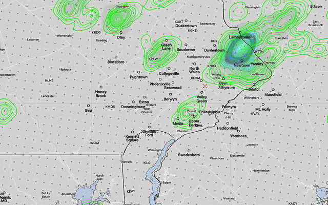
Some of lightning today was cloud->ground and was dangerously spectacular to view.   CAPE (Convective Available Potential Energy)  values today were high —in the 2800 range (compare to last week’s storms which were only in the 1700 J/kg range.)

A repeat performance expected on Wednesday, likely 2-6 PM and somewhat more in NJ.  

Another very warm day is in store for us on Tuesday. Temps will be in the upper 80s, but an increase in humidity will more than make up for it.

Upper air disturbances will move through, around noontime, triggering scattered showers and thunderstorms in many areas, starting as early as noon- 2 PM and lasting in some areas into the evening.

HREF (High Resolution Ensemble Forecast) hourly precipitation with standard deviation, at 12 PM, 2 PM and 5 PM with increasing areal coverage. (Click on image for a larger view.)

High CAPE (potential energy), high instability values and high precipitable water values could make for some heavy rains in localized areas. Overall, the models are cranking out 0.5 inches of rain.

WEEKEND WEATHER FORECAST

Updated Sat 11:06 PM: Sunday forecast update is highlighted below:

Following two days of active weather, the forecast for this weekend is straightforward — high pressure builds in, both at the surface and aloft, bringing sunny skies and unseasonably warm (hot) temperatures, a marked change from last weekend.

Indeed, while last weekend featured temperatures in the mid 40s, this weekend, we’ll be catapulted into the low 90s!

Sunny and very warm. High temperature 90.8º sd 2.8º (NBM Blue Bell)

Sunny and hot. High 93.3º sd 3. (NBM Blue Bell) High temp still expected to be about 93 ± 2º. Dew points near 62º are beginning to reach a noticeable level, but still not very high. Tonight’s models show the possibility of an isolated thundershower far north of the city late Sunday afternoon.

An increase in the chance of thunderstorms on Monday, mostly west of the city and a significant increase on Tuesday and Wednesday in much of southeastern PA.

Winds
NBM wind meteogram for Blue Bell, PA  (Click on image for larger view)