
Update Sun 04:34 PM — OK, it WAS a beautiful spring-like day, even though didn’t reach 70º.
Some interesting weather on tap for next Saturday, likely changing to all rain.
Today, I’m simply playing with a ‘live blogging’ type format. This may be a cleaner look for rapidly changing weather situations [su_note note_color=”#defcdc”]instead of the box format I’d been using previously.[/su_note]
Update Sun 12:37 PM – The temps are maintaining about 64-65 and the winds have diminished somewhat. Temps expected to remain in low 60s until 3-4 PM.
Update Sun 08:30 AM — The front moved through as forecast and the winds have picked up. Expect sunny skies for the rest of the day with winds gradually diminishing.
…Posted this morning—
As expected, we are NOT going to reach 70º today; all of the models had started to back off of that forecast on Friday evening and have continued with a forecast high of about 64º today, probably already reached.
Here’s the EKDMOS I posted on Friday–
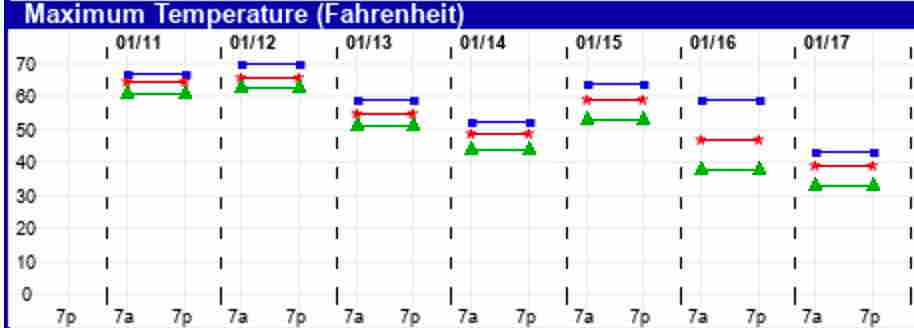
The EKDMOS, being an advanced statistical post-processing handling of 20 version variations (called “perturbations”) of the GFS model, shows the actual potential forecast temperature range being forecast was 63-70. The average was closer to 65 (red line). I was persuaded initially to go with the upper limit, but I began having my doubts as the the models rolled in Friday evening and posted my skepticism in a later update.
Temperatures will gradually fall into and through the 50s today. With the wind, the “spring like temperatures” predicted by the weather entertainers won’t make all that much sense.
Still no chance of any snow predicted in coming weeks, although a mixed-precipitation event is possible on Saturday before a change to rain.