
#Philadelphia #weather #PAwx
Sunday Update
Posted Sunday 01/28/24 @ 10:54 AM — Light rain is expected to continue, perhaps with a slight lull in the action between 11 AM and 2 PM in areas south and east of city. Another batch of somewhat heavier rain expected between 3 PM and 6 PM, then tapering off by 8 or 9 PM.
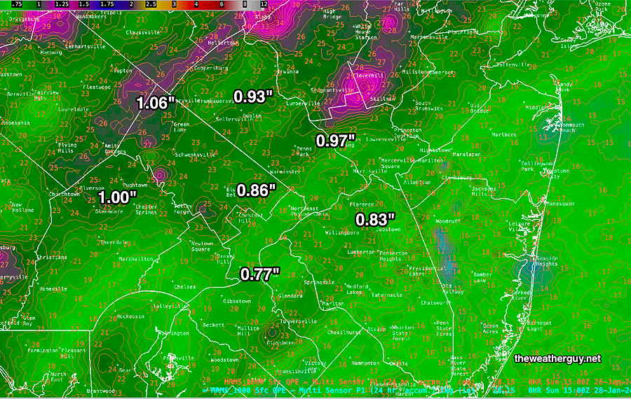
So far, we’ve received about 1 inch of rain in many areas (through 10 AM) according the the MRMS summary. An additional quarter inch of rain is expected by the time it ends—
That ending in snow showers looks increasingly unlikely in this area.
Sunday Forecast Update
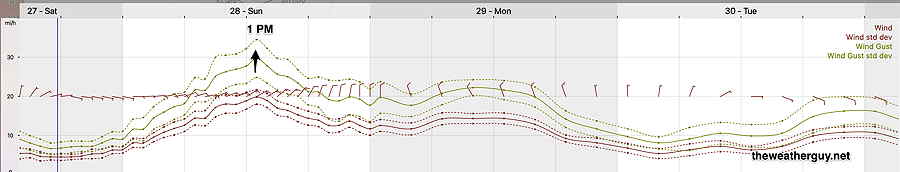
Posted Saturday 01/27/24 @ 5:44 PM —Rain is still expected to move in tonight between 11 PM and 2 AM, somewhat later than forecast yesterday. The heaviest rain from 5 AM through about noontime, but showers and light rain continue into the evening. Rainfall totals look to be in the 0.80″ to 1.3″ inch range in our area. It will become quite WINDY and gusty. Wind gusts to 35 mph.
Cold air rushes in aloft Sunday night, but the any change to snow showers will be very limited, (if it occurs at all) and no accumulation is expected anywhere around here. Temperatures near the ground expected to remain above freezing.
That poor track record continued into today with cloud cover much less than anybody (especially me, with my reference to this morning’s NBM) would have predicted.
At least from the city westward, we had quite a nice long stretch of sunshine. I always like to go back and see what model, if any, got this right. The HRRR 15z, available about 11:15 AM showed significant sunshine in the afternoon, but disappearing behind clouds about 2 PM. The Canadian HRDPS showed not a cloud in the sky west of the city. That was overdone. The experimental RRFS had significant clouds with a break for an hour or so, the clouds back about 2 PM. Looking back, the German ICON model had the best match in cloud cover. Go figure.
Saturday Forecast Update
Posted Saturday 01/27/24 @ 8:16 AM — The models have not been doing a stellar job.
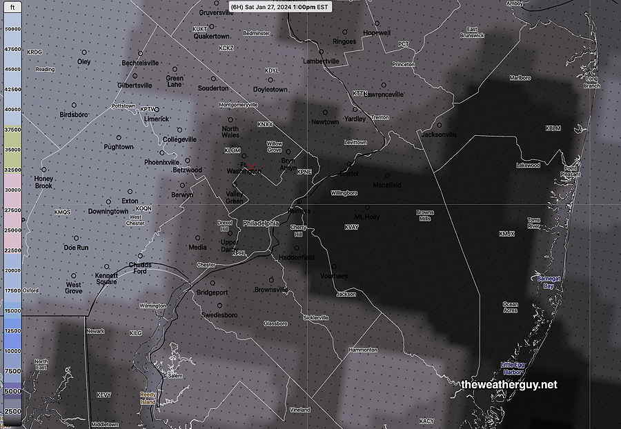
The fog has lingered in some areas longer than forecast last night. Last night’s models continue to forecast a break in the clouds from the city westward with some sun by late morning lasting until about 1-2 PM. HOWEVER, the latest NBM (12z) just available keeps a layer of low clouds, no sun.
Here’s the latest NBM cloud ceiling forecast for 1 PM today—
Rain expected by 10-midnight this evening. Highs in the 48-50º range.
Previously Posted Fri 6:07 PM —
As of this posting, the stalled warm front remains to our south and we remain socked in with fog and light mist. The front will retreat southward with somewhat colder drier air moving in from the northwest tonight.
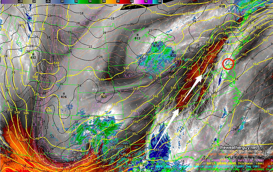
A system is developing over the Gulf States that will move in late Saturday night with rain for Sunday.
This developing system for Sunday is visible on this water vapor image from late Friday afternoon—
Saturday
Fog should dissipate after midnight Friday. We’ll have a break in the clouds by mid morning and we should see some sun Saturday around noontime before more clouds roll in early afternoon ahead of the next system.
Rain moves in from the southwest between 10-11 PM Saturday evening.
NBM high temperatures: Blue Bell, PA 50º Philadelphia, PA 52º
Uncertainty (based on standard deviation of 2.5º): slightly more than average
Sunday
Cloudy with rain. Heavy at times. About 1 inch total rainfall. Rain/snow showers tapers off about 10 PM.
Low pressure intensifies along the coast Sunday evening as colder air enters the system from the northwest—
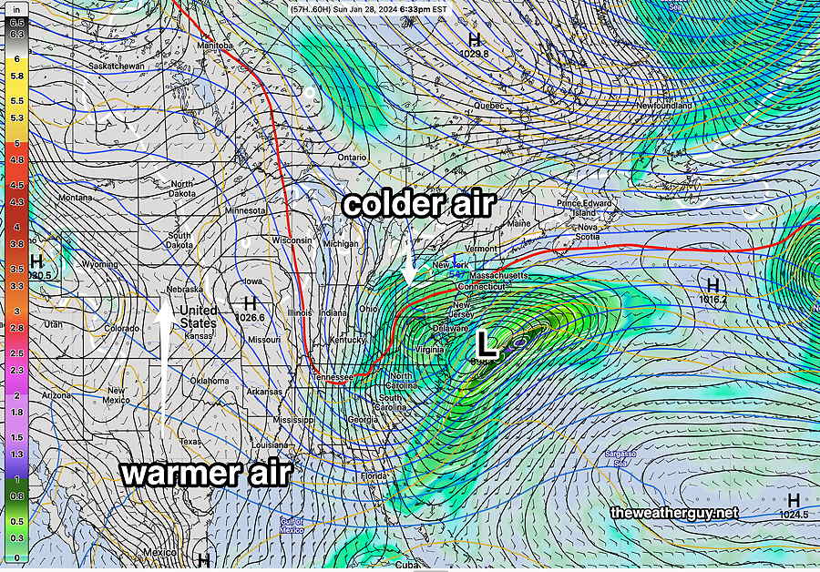
Rain changes to snow showers during the evening from northwest to southeast. No accumulation in our area.
NBM high temperatures: Blue Bell, PA 40º Philadelphia, PA 41º
uncertainty (based on standard deviation ± 2.2º): more than average