FYI, NOAA model data, usually available on their website called “NOMADS“, has been inconsistently available today.
NOAA, over recent days, has changed SSL certificates and has attempted to move their data over to Akamai’s CDN (Content Delivery Network).
This changeover has been fraught with difficulties over recent days. With NOMADS not working, NOAA’s backup server is overwhelmed.
It’s been difficult to get a complete download of the NAM, GFS and other models. With little data available, it’s been tough to do a forecast.
Updated Fri 8/26 8:23 AM — Many of last night’s models have significantly downplayed the chances of showers today in our area. The NAM-NEST continues with very widely scattered showers around 5 PM.
Update Thu 08/25 @ 8:11 PM — The weather has been on easy auto-pilot the past few days with increasingly warm and humid conditions.
Friday will have the warmest temperatures of this week with temps in the low 90s in many areas.
A weak front will move through Friday afternoon. Most of the US models have kept any showers to the far north of Philadelphia. But, this afternoon’s NBM, Canadian RGEM, and the ECMWF shows some light showers and thundershowers developing west of Philadelphia in the mid afternoon and moving eastward.
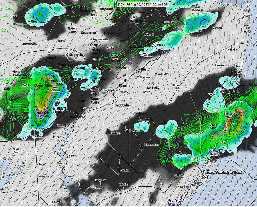
Canadian High Resolution (HRDPS) forecast for 4 PM Friday (1 hour Precipitation rate and 3 Hour accumulated Rain) (Click on image for a larger view.)
This is a relatively new development, since the previous days model runs had no showers in our area.
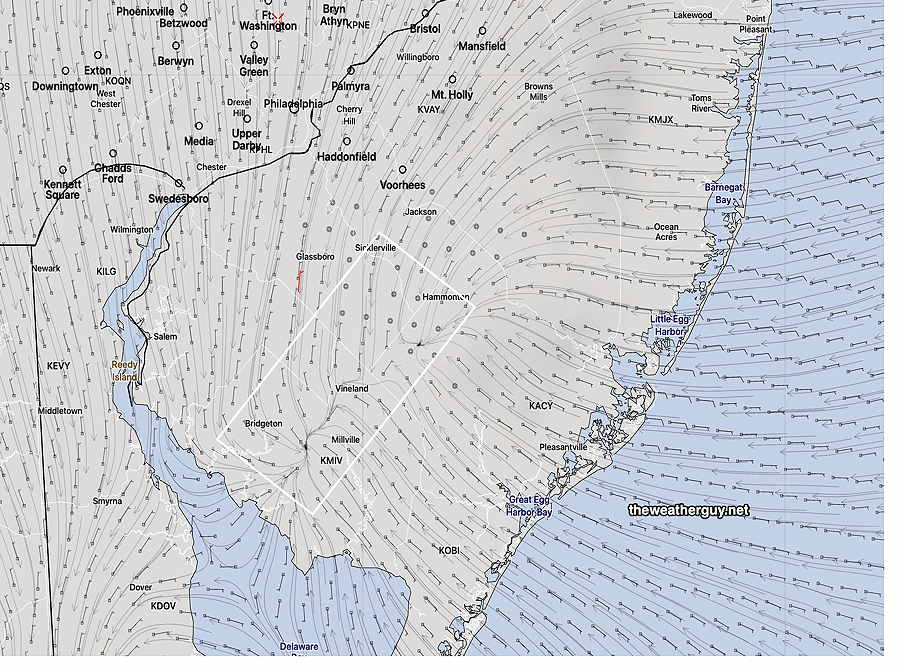
A bit of uncertainty for the weekend forecast, as the high pressure system behind the front will move off to our north creating an easterly flow here. Some degree of cloudiness and possibly some afternoon showers are possible as the models have an easterly flow converging with a westerly flow.
NBM surface winds Saturday 3 PM. The wind streams clearly show an area of horizontal wind convergence, forcing air upward causing showers to develop. (Click on image for a larger view.)
The Jersey shore may be most affected by this easterly flow. The uncertainty in the weekend forecast should clarify over the next day. Stay tuned.
Quiet and increasingly hot
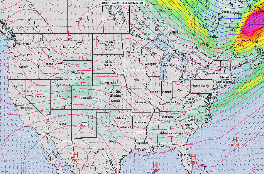
Update Tue 08/23 @ 5:40 PM — The balance of the week will be influenced by a very weak upper flow. (The main jet flow is north into Canada.)—
NAEFS statistical “mode” Friday forecast jet stream level contours at 250 mb. Slow, stagnant flow over the US. The little wave in southwestern PA is a weak front. (Click on image for a larger view.)
Increasingly warm and humid through Friday. High temperatures upper 80s Wednesday and low 90s Thursday and Friday. A weak front moves through Friday evening. The long range models show little chance of rain in the coming week.
Update Tue 08/23 @ 5:38 PM — A more zoomed in version of the accumulated rain graphic—
MRMS accumulated rain. Contours are in millimeters. 25.4 = 1 inch. Color code is in inches with legend at the top. (Click on image for a larger view.)
Update Tue 08/23 @ 9:05 AM —Many, but not all areas, received significant rainfall since Sunday afternoon. Here’s the MRMS rainfall totals—
MRMS 48 hour rainfall totals. Contours are rainfall in mm. Color coding is in inches. (Click on image for a larger view.)
Yesterday afternoon’s 19zHRRR did well in predicting the additional rain and thunderstorms that evening.
Additional Showers and Storms Monday Evening
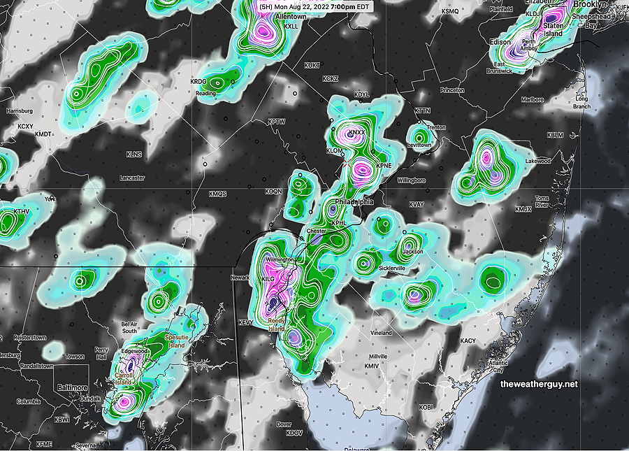
Update Mon 08/22 @ 5:56 PM —This morning’s HIRESW (high resolution models) weren’t all on-board with much additional rain this evening.
However, the 19z HRRR shows some significant rains/thunderstorms popping about 7-8 PM in the immediate PHL area.
19z HRRR showing some heavy showers/thunderstorms 7 PM (Exact location of heaviest rain shouldn’t be taken literally) (Click on image for a larger view.)
Monday showers not a drought-breaker
Previously Posted Mon 10:20 AM —
Additional showers and maybe some thunderstorms during the day today (Monday), but the latest HRRR and RAP shows much of the activity today before 1 PM, with another round this evening.
Much of the remaining rain forecast by this morning’s models will fall to our west, north and south, with only about 0.3″ additional in the immediate PHL area.
Last night’s rain was disappointing, except in some areas (not forecast).
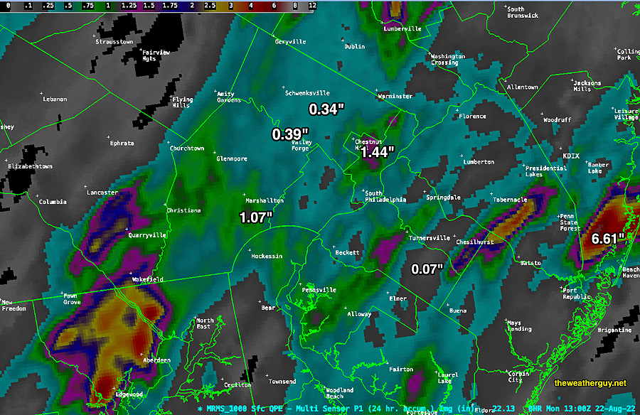
MRMS past 24 hour rainfall accumulation as of 8 AM Monday. Much of the area had much less than forecast. The rain maxima over Chestnut Hill/Germantown was partly from the localized rainfall that went through Sunday afternoon. (Click on image for a larger view.)
Not much of a drought-breaker so far, But we’ll have to see what develops later today and where.