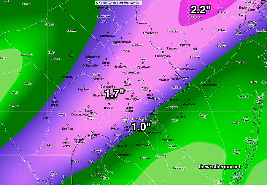
Posted Friday 01/12/24 @ 7:29 AM — First, tonight’s rainstorm. No significant changes seen in the forecast for tonight’s flooding rains. The rainfall map from last night’s models is similar and the high wind gusts expected also similar.
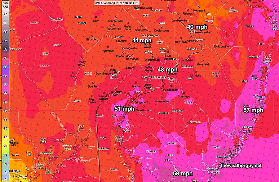
Here’s the wind gusts expected at 1 AM Saturday morning—
01-12-24 06zNBM model forecast mean wind gusts at 1 AM Saturday morning. (Click on image for a larger view.)
Friday evening, rain moves in between 6:30 PM and 9 PM from southwest to northeast. It’s a fast moving system and the rain ends before daybreak, possibly with a few lingering sprinkles early morning.
A mix of clouds and perhaps some sunny breaks Saturday morning. Considerable cloudiness early afternoon, then more sunshine by mid to late afternoon. WINDY.
Snow Storm Tuesday?
Several models, with the noted exception of the ECMWF, are predicting a coastal low to intensify and bring mostly snow to our region. The storm is still 120 hours in the future and only in the range of the global models and their ensembles.
I know there are plenty of snow lovers who follow this site and I’m providing a snow accumulation graphic below just to give an idea of what I think is possible.Way to early to take this literally and with the ECMWF not buying into the snow forecast, this is a low confidence situation—
01-12-24 06z NBM based snow accumulation calculation through Wednesday evening. (Click on image for a larger view.)
Beginning tomorrow (Friday) morning, I’ll be covering that potential Tuesday snowstorm here; the chance of a significant snowstorm, especially for western and northern suburbs, has moved from speculation to possible.
Friday Rain Storm
Posted Thursday 01/11/24 @ 5:51 PM — This afternoon’s NBM has increased the expected total rainfall for Friday night in our area.
Here’s the latest—
01-11-24 19z NBM model total rainfall forecast for Friday night. (Click on image for a larger view.)
Rain moves in somewhat later, about 9 PM from west to east. Rainfall heavier than previously forecast, per above graphic.
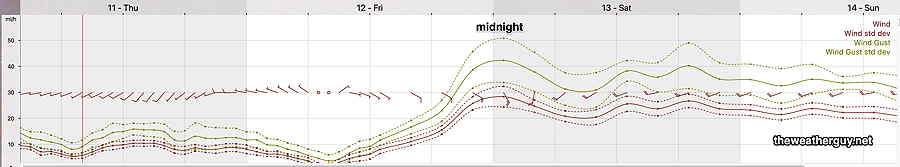
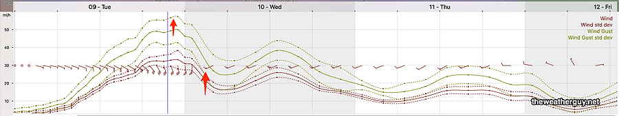
Windy towards midnight with gusts 40-50 mph—
01-11-24 NBM 19z wind meteogram for Blue Bell, PA (Click on image for a larger view.)
Rain tapers off mid to late morning Saturday. It remains very windy.
Today, Thursday will have early clouds breaking for sunshine. Highs Blue Bell -45º Philadelphia – 47º. Still somewhat windy and gusty.
Friday will be partly cloudy in the morning, becoming cloudy by the early afternoon. Rain begins between 6 PM and 9 PM, an hour or so earlier southwest Chester county. Total rainfall looks to be significantly less than Tuesday’s storm. Wind gusts again may approach 40-50 mph at night.
01-11-24 12z NBM total rainfall is forecast to be considerably less than Tuesday night’s storm (Click on image for a larger view.)
Winds
01-11-24 06z NBM wind meteogram for Blue Bell, PA (Click on image for a larger view.)
Saturday: rain will end mid morning, becoming partly cloudy/sunny. VERY WINDY. Colder
Sunday: partly sunny/cloudy, less windy. There may be some snow flurries in the afternoon as a secondary cold front moves through with an upper air disturbance.
Monday: Colder
There’s increasing signal for some (an inch or two) of accumulating snow late Tuesday. Still uncertainty.
Today, I updated my Winter OutlookPage about potential future storms in the coming weeks.
Friday into Saturday Rain Storm
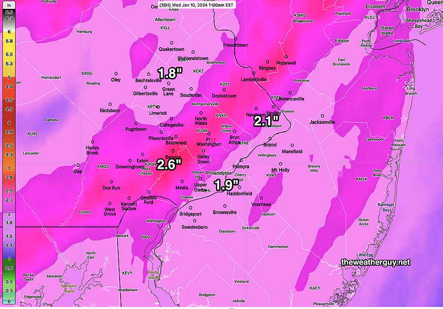
Posted Wednesday 01/10/24 @ 7:46 PM — This afternoon’s models have backed off on the heavy rain in our area Friday night.
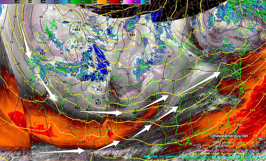
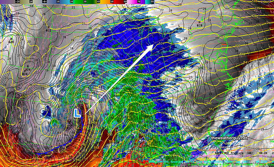
Posted Wednesday 01/10/24 @ 5:02 PM — Another disturbance dropping down in the northern jet stream flow will combine with a southern jet stream disturbance, creating yet another similar, (but not as powerful) low pressure system—
Current (Wed afternoon) satellite water vapor image with superimposed RAP model 500-1000 mb thickness lines (yellow), Mean Sea Level Pressure isobars (black contours) potential vorticity (fine violet contours) with superimposed MRMS RADAR. A strong disturbance (violet contours) in the northern jet dropping down along the Pacific coast will combine with the southern jet flow, spawning yet another low pressure system. (Click on image for a larger view.)
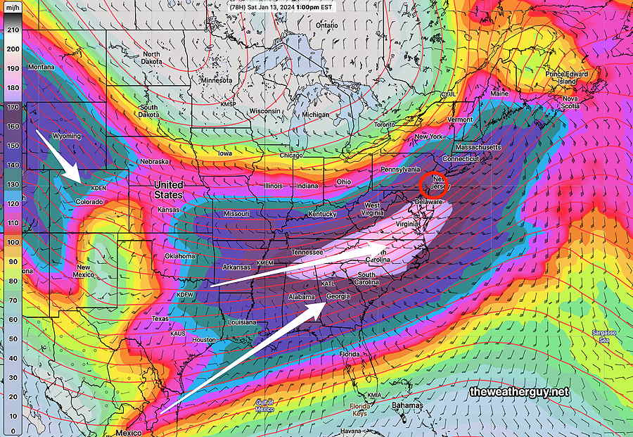
The NAEFS model’s forecast for 1 PM Saturday shows the combined jet stream and an enhanced area of high speed winds called a jet streak—
01-10-24 12z NAEFS model jet stream wind level (250 mb) forecast for Saturday at 1 PM. White area is >185 mph winds aloft.
This will be another night-time moderately heavy rain event.
Here’s the storm as forecast by the today’s ECMWF at 1 AM Saturday—
01-10-24 12 z ECMWF forecast for 1 AM Saturday morning. Another night-time heavy rain event. (Click on image for a larger view.)
Rainfall will be moderately heavy, not as heavy as Tuesday night’s storm, but saturated ground conditions will make be problematic. Wind gusts again will be high around midnight, in the 40-50 mph range!
01-10-24 12z GFS forecast total rainfall expected by noon Saturday. (Click on image for a larger view.)
It looks like the rain will begin after 6 PM Friday, earlier far western suburbs. Faster moving, it will end around daybreak Saturday with some clearing.
Stay tuned for updates.
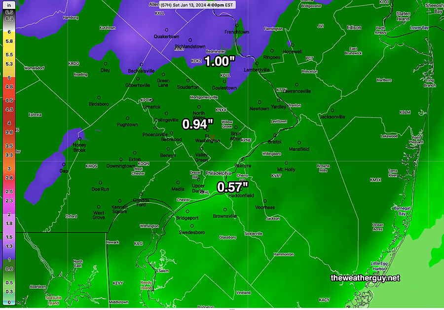
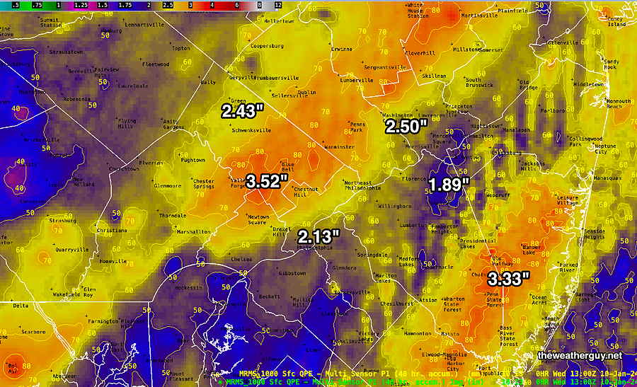
Wed 8:32 AM —Forecast Review —That was an impressive storm and the rainfall and wind forecasts were spot on.
Here’s the MRMS based final summary of the total rainfall we received with this storm —
MRMS combined rain gauge & radar-based measurement of rainfall received. Color shading is in inches. Line contour numbers are in mm (25.4 mm= 1 inch) (Click on image for a larger view.)
Just to note, the storm moved as had been expected and exited about an hour or two sooner than had been forecast.
For those of you who might want to follow the river flooding, the USGS (Unites States Geological Survey) maintains river gauges and posts live, real-time data on their web site . For the Perkiomen Creek-
I’ll be posting about the next rain storm late Friday and the cold outbreak to affect us next week later today.
Height of the Storm
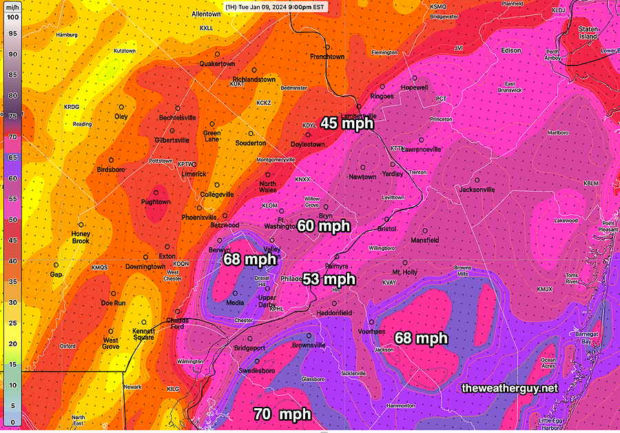
Posted Tuesday 01/09/24 @ 9:26 PM — Hearing the wind outside our home, I had to run another RTMA download. Here’s the wind gusts measured/interpolated at 9 PM—
0200z RTMA (9 PM EST) actual wind gusts measured/interpolated. (Click on image for a larger view.)
Incredibly, the 01z HRRR has higher wind gusts for us at 10 PM!
MRMS combined rain gauge & radar-based measurement of rainfall received through 9 PM. Color shading is in inches. Line contour numbers are in mm (25.4 mm= 1 inch) (Click on image for a larger view.)
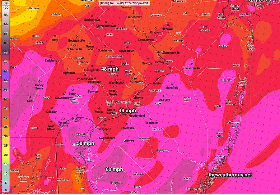
Posted Tuesday 01/09/24 @ 7:56 PM — We’re approaching the height of the storm. Here’s actual measured and extrapolated wind gusts measured at 7:30 PM tonight—
RTMA 7:30 PM (Click on image for a larger view.)
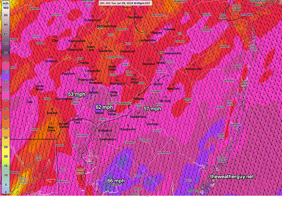
Here’s what the latest hourly HRRR model is forecasting for 9 PM—
01-09-24 23z HRRR wind gust forecast for 9 PM. (Click on image for a larger view.)
Heaviest Rain and Wind
Posted Tuesday 01/09/24 @ 4:11 PM — The heaviest rain and the highest winds will be this evening through about 1 AM.
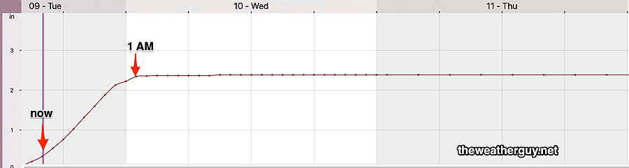
The rain should increase in intensity by 5 PM and remain quite heavy. An additional 2.2 inches + is possible, bringing the totals to 3 + inches in many areas.
18z NBM model rainfall. “now” is 4 PM. Steep slope shows 2.3 inches in (Blue Bell) over a 12 hour period! (Click on image for a larger view.)
The big concern is the wind and wind gusts, expected to peak between 10 PM and midnight in the immediate Philadelphia area. Here is the latest NBM model wind gust forecast for 10 PM—
01-09-24 18z NBM model blend wind gust forecast with standard deviations at 10 PM. (Click on image for a larger view.)
The NBM , as an average of numerous models, tends to be conservative with its wind forecasts. The latest NAM and NAM-NEST (not shown) have well over 65 mph gusts for a large portion of the area.
Tuesday Storm Update
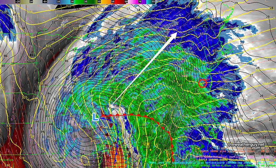
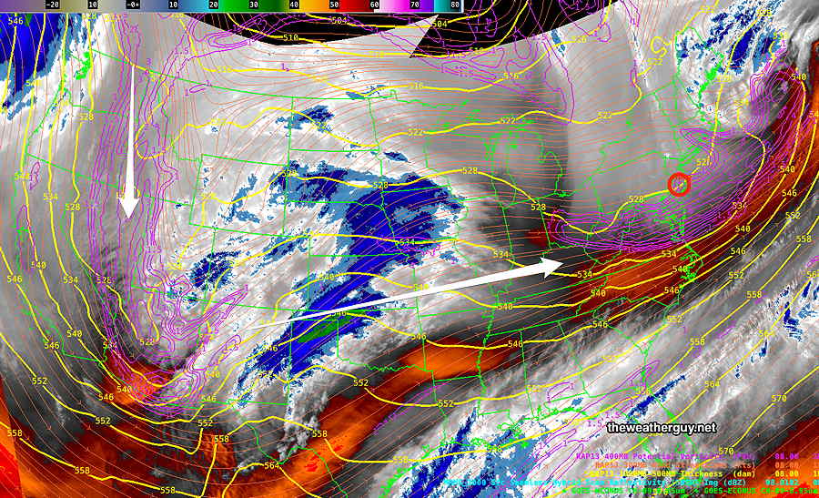
Posted Tuesday 01/09/24 @ 11:36 AM — Here’s the current water vapor image of the storm at 11:30 AM—
Current satellite water vapor image with superimposed RAP model 500-1000 mb thickness lines (yellow), Mean Sea Level Pressure isobars (black contours) potential vorticity (fine violet contours) with superimposed MRMS RADAR. (Click on image for a larger view.)
This morning’s models continue with a basically similar forecast. Each model varies somewhat with rain totals and the areal placement of the heaviest rain bands. Here’s this morning’s latest HREF model. (The HREF, being an ensemble model combines various higher resolution models into a statistical mean.)
01-09-24 12z HREF accumulated rainfall by 3 AM Wednesday. (Click on image for a larger view.)
The latest Canadian HRDPS is very similar. (The latest GFS, ECMWF and German ICON models have trended towards the heaviest rain in Northern NJ and NYC, but still crank out over 2 inches of rain in our immediate area.)
We’ve had several storms over the past month that threatened heavier rainfall. The issues with this storm:
• HIGH WINDS and WIND GUSTS around 50-60+ mph. • Saturated ground conditions, existing snow cover north and high river levels at the start. River Flooding appears likely. Flooding often occurs towards the end of the storm and in the hours afterwards.
Highest winds increasing in the evening and especially towards midnight, ahead of the cold front passage about 1 AM or so.
Tuesday Storm Update
Posted Monday 01/08/24 @ 10:43 PM — Tonight’s high resolution models continue with same forecast, but there will be bands of rainfall of over 3 inches. Wind gusts continue to be forecast in the 50-60 mph range in the period between 9 PM and midnight Tuesday evening. The leading edge of the rain moves in between 8 AM and 11AM.
Posted Monday 01/08/24 @ 5:49 PM — A deep low pressure system and associated sharp cold front will affect our weather on Tuesday into early Wednesday with heavy rain, high winds and likely stream and river flooding.
Current satellite water vapor image at 5 :30 PM Monday with superimposed RAP model 500-1000 mb thickness lines (yellow), Mean Sea Level Pressure isobars (black contours) potential vorticity (fine violet contours) with superimposed MRMS RADAR.
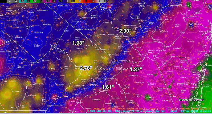
The latest NBM accumulated precipitation forecast is for a generalized 2 to 3 inches of rain, beginning with light spotty showers as early as 9-11 AM (earlier in Chester and Delaware counties) with increasingly heavy rain into the evening and around midnight—
01-08-24 18z NBM accumulated rainfall through 1AM Wednesday. (Click on image for a larger view.)
Of concern is the increasing wind velocity and gusts expected with this deep low. Gusts over 50 mph and overall sustained winds of 30 mph will be likely towards midnight Tuesday.
NBM wind and wind gust meteogram for Blue Bell PA. High winds and gusts towards midnight. The front comes through with an abrupt change in wind direction at about 2 AM Wednesday (second red arrow) (Click on image for a larger view.)
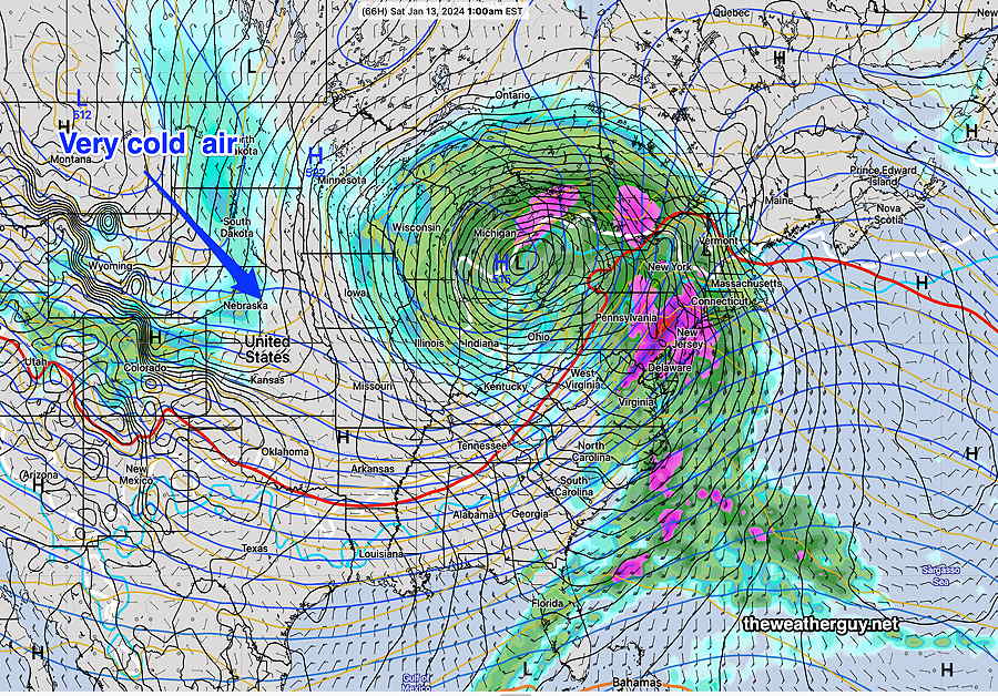
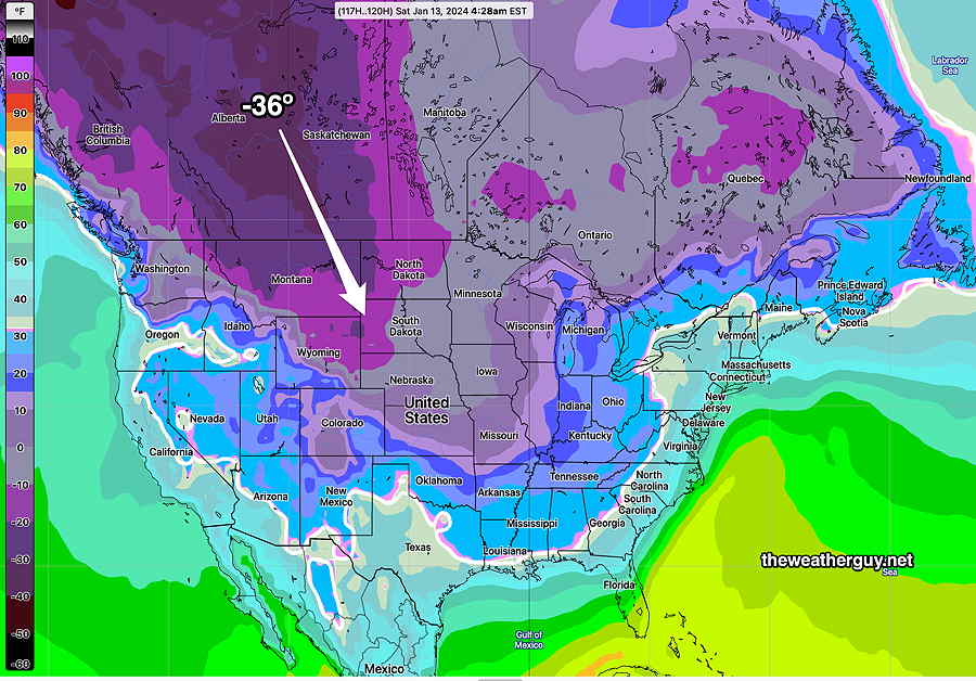
Another rainstorm is expected late Friday afternoon into Saturday morning bringing yet another 2 inches or rain. Following this storm, deep cold air is poised to move into the US—
01-08-24 12z NAEFS temperatures Saturday morning. Deep cold air mass in Alberta Canada is poised to descend into the US. (Click on image for a larger view.)
Tuesday Rain Storm Update
Posted Monday 01/08/24 @ 8:23 AM — The deep low pressure system looks to be moving in somewhat earlier than previously forecast. The rain moves in about 9-11 AM from the southwest, somewhat earlier in Chester and Delaware counties.
I know the models often predict wind gusts that seem to be in excess of those actually seen, but the wind gust model forecasts with this storm appear unusually impressive, with several models showing wind gusts anywhere from 50- 60 mph gusts and higher at the shore. These will occur Tuesday evening
01-08-24 06z GFS winds and gusts wind meteogram for Blue Bell, PA Also notice the wind shift about 1-2 AM indicating the cold front passage. (Click on image for a larger view.)
Rainfall is expected to be 2-3 inches in our area. With snow melt occurring due to warm winds bringing near 60º temperatures Tuesday evening, river flooding is looking increasingly likely.
Previously Posted Sun 8:48 PM —
A storm system near Arizona/Colorado will move northeast to the Great Lakes and rain from this system will move in Tuesday afternoon ahead of a cold front Wednesday.
Current satellite water vapor image (Sunday evening) with superimposed RAP model 500-1000 mb thickness lines (yellow), jet level wind streamlines (orange contour-arrows) potential vorticity (fine violet contours). This system will bring rain to our area Tuesday into Tuesday night. (Click on image for a larger view.)
Rain associated with this system will move in on Tuesday, likely in the early afternoon, and will become heavy Tuesday evening as temperatures rise to almost 60º. The rainfall is expected to be heavy (about 2″) but recent trends have reduced it from the 3″ previously forecast. Some river flooding is possible. High winds will be an issue.
01-07-24 18z NAEFS forecast for Tuesday at 7 PM Heavy rain expected here, but the heaviest rain now is forecast to be south and north of the Philadelphia area. A cold front moves through Wednesday. (Click on image for a larger view.)
But a quick look at tomorrow, Monday— mostly sunny, windy in the morning, diminishing winds in the afternoon. High in the low 40s.
Incredibly, another heavy rain event this coming Saturday.