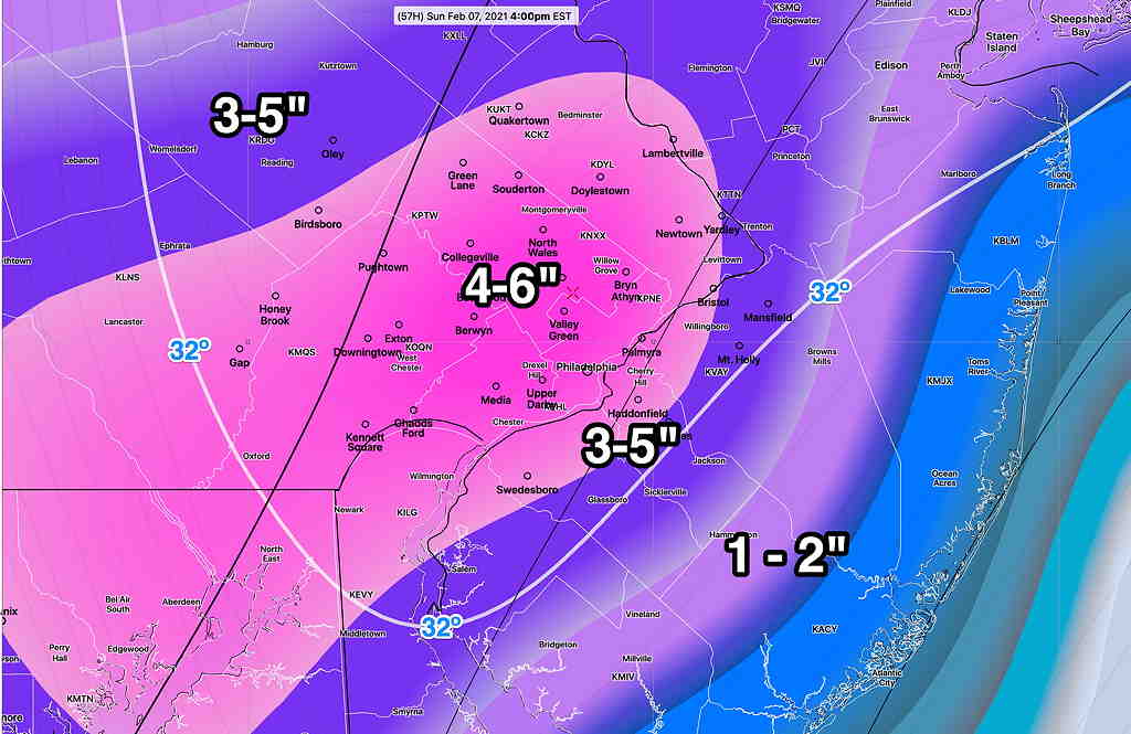
Forecast Updated Sun 8:00 AM— Last night’s model blend has continued to reduce final snow totals by about 1 inch less those posted below. Dynamic cooling has only reduced surface temps to above or about 32º which may limit full accumulation on roadways.
8:11 AM. It should be noted that the NAM continues to predict almost 6 inches.
New models by about 9:15 AM
Forecast Updated Sat 9:11 PM — Tonight’s NBM, HRRR, RAP and NAM models have become available. The model blend (NBM) continues with the trend of slightly lower snow totals, although the spread of possibilities remains somewhat large—
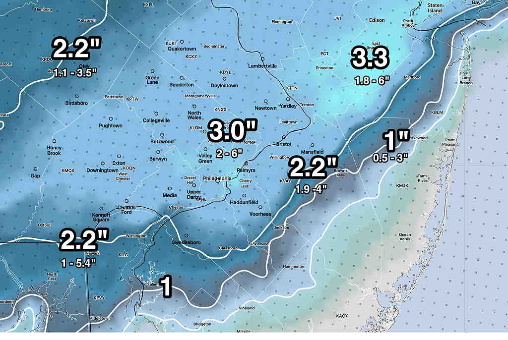
The NBM 3 inch snow totals are in line with the RAP (4 inches) and ICON (3.5 inches), HRRR 2.5 inches.
The latest NAM, just available, is highest and still shows 6 inches, which accounts for the high spread in the percentiles.
I’m inclined to go with the NBM model numbers and probably 3-4 inches is a good forecast at this point for most of the area.
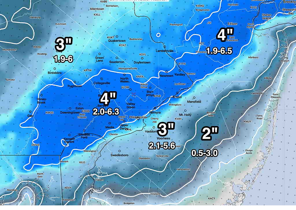
Forecast Updated Sat 6:10 PM — The 4PM Model Blend has reduced the 50 percentile snow totals by about 1/2 inch. See graphic below.
Forecast Updated Sat 5:18 PM — This afternoon’s 1PM, (18z) models are in.
The models are in good agreement that the predominant precipitation type will be snow in the immediate Philadelphia area, starting between 5 and 7 AM and ending around 2-4 PM.
QPF values are stable in the 0.4-0.55 inches water equivalent. Current GFS water -snow ratio is in the 9.8 to 1 range. That is in good agreement with the current Model Blend (NBM) percentiles.
The NBM 50 percentile is shown below shaded with the 25 and 75 percentiles below it. (Remember, if you are were in the 90 percentile in your school test grade, it meant that your score was equal or greater than 90 percent of the other students. It doesn’t mean that 90 percent of the other students got the same test score as you.)
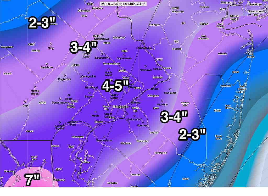
Food for thought is the ICON model which is remarkably similar to the NBM 50 percentile—
It’s not expected to be windy during the storm. Winds pick up Sunday evening.
Forecast Updated Sat 9:01 AM — The trend is back to mostly snow for Philadelphia but less total QPF.
First some model info:
The major numerical weather prediction models are run every 12 hours, or twice a day, at 00z and 12z (7 AM and 7PM EST). Depending upon the model, it takes 1.5 to 6 hours to complete their calculations.
Some of these major models have an additional run at “06z” and “18z” (at 1 AM and 1 PM EST.) (Not to complicate, there are hourly models too.)
Looking at the both of these major model runs from last night, the trend is for a lower QPF (total quantity of precipitation falling) than had been predicted Friday afternoon. As an example, the NAM QPF for Philadelphia has reduce to almost 1/2 the amount from yesterday’s model run.
The models have clustered at a total QPF for our area between 0.3 and 0.6 inches of water or snow-water equivalence. For areas that will be all-snow, that translates into 3-6 inches of snow based on a 1:10 ratio.
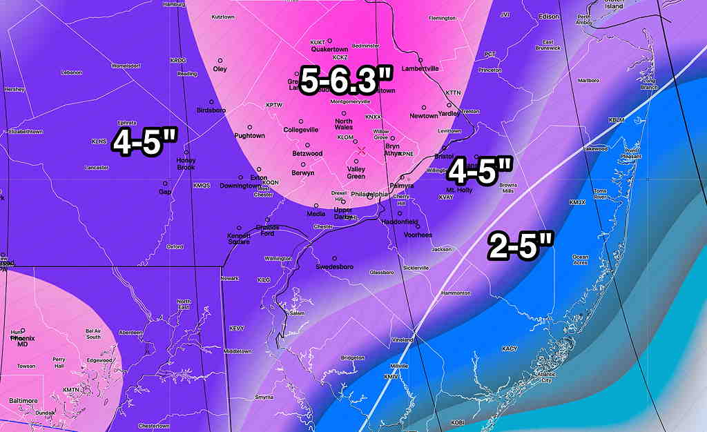
Here’s the latest ICON model from 06z which is at the high range—
Here’s the SREF model showing precip type that I referenced last night. Notice that it now has the snow-rain line south of Philadelphia, meaning more snow, less rain, for the immediate PHL area. A significant change—
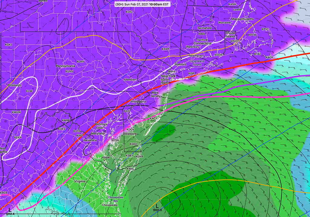
Final forecasts of the rain snow line, surface temperatures and the amount of QPF will need to wait until this evening’s models come in.
Stay tuned.
Forecast Updated Fri 9:27 PM — A significant forecast complication has emerged. Tonight’s models just becoming available show the low pressure system closer to the coast, bringing milder air in. What was going to be all snow may now mix with sleet and rain, reducing snow totals significantly from what I had just posted below. Here’s the latest SREF forecast showing the critical “thickness lines” (measures of average density of atmosphere layers correlated with temperatures) are now north of Philadelphia by 1 PM
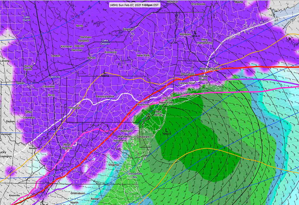
If this trend continues, those high snow totals are going to wrong.
I used the latest NBM model (from 7PM- 00z ) for the snow totals below. Unfortunately, the way the NBM model works, it takes at least 6 hours for the new models (with their warmer forecast) to work their way into the NBM blend.
Weekend Weather Forecast & Sunday Snow Update Fri 8:45 PM —
First, the regular Weekend Weather Forecast: Saturday, mostly sunny. Cloudiness moves in towards evening. High 37º ± 2º (Blue Bell- NBM model). Winds 10-15 mph with gusts to 30mph mid-day.
Sunday: Snow begins 4-6 AM as low pressure develops and moves just south of us. Snow heavy in the morning, tapering off in the afternoon. The trend has been for increasing snow totals and the trend for the heaviest snow right over Philadelphia and just east.
Using the model blend (NBM) 24 hour snow accumulation percentiles here’s where things look right now—
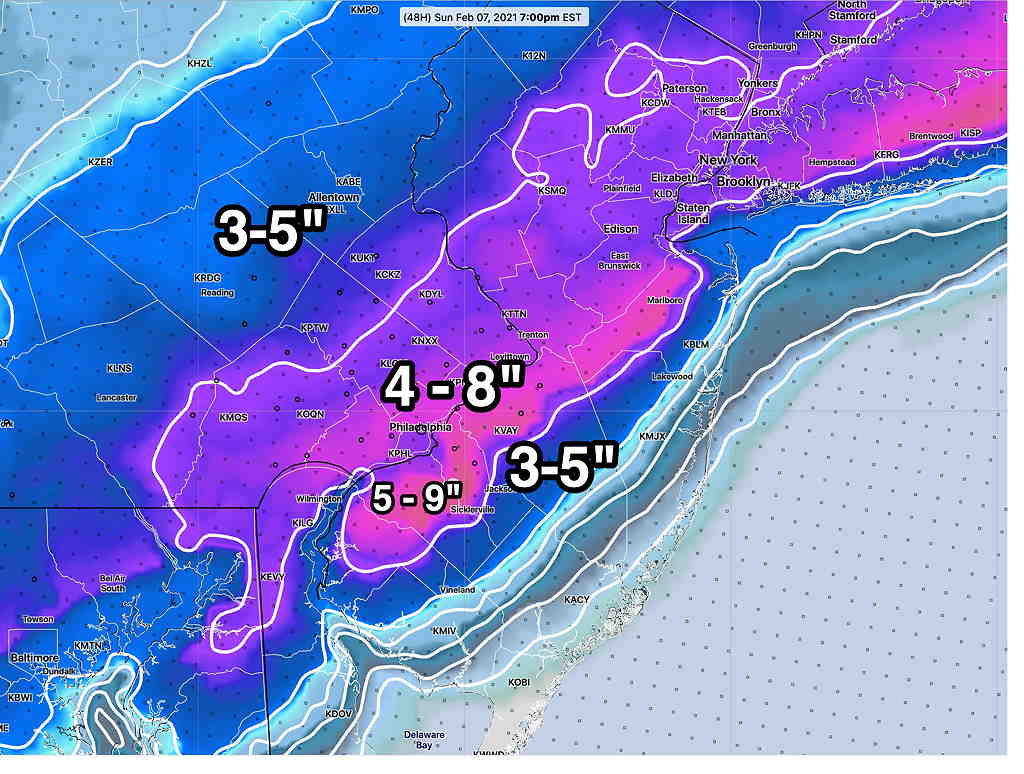
The spread is large because I’m using the NBM 25/50 and 90 percentiles; I’m including the 90 percentiles because this afternoon’s NAM was predicting in the high range.
(A 25 percentile means that 25% of the models are predicting up to that amount; a 50 percentile means that half of the models are predicting less than that amount and half are predicting more: a 75 percentile means that 75% of the models are predicting less than that amount. But it does NOT mean that 75% are predicting that amount. You gotta wrap your head around it.)
The latest ICON model from this afternoon has the following—
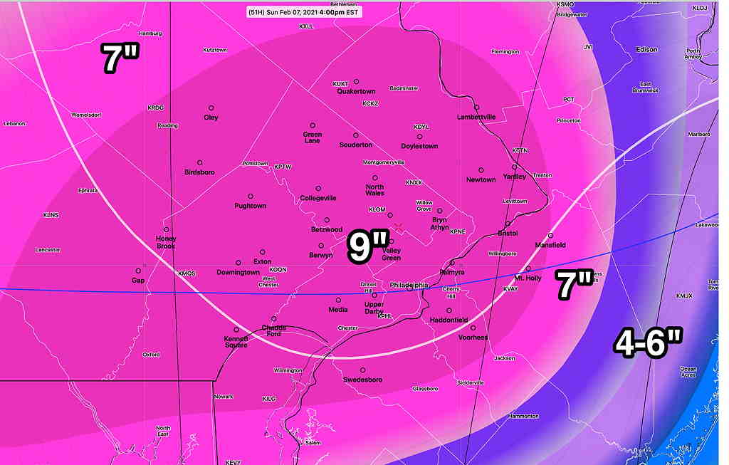
Why am I using the ICON model?? It was one of the first this week to consistently show significant snow for us. During our last storm, it was surprisingly good.
Stay tuned …
Forecast Updated Fri 5:51 PM — This afternoon’s models are pointing to a more significant snowfall for Sunday, starting before daybreak and ending in the afternoon. Most of the immediate Philadelphia area will have all snow. Using my old technique of snow-water equivalence, 4-10 inches of snow is possible in the immediate PHL area. The ICON model shows these snowfall totals—
The latest NAM model forecasts 2-4 inches greater than the above totals and the latest GFS is at the upper end of the range shown in the graphic.
This marks a major change in the forecast for this storm, that previously had been expected to pass by to our south, missing us.
Stay tuned for an additional update with tonight’s models.
