
#Philadelphia #weather #PAwx
Sunday Night Rain Update
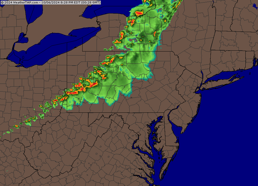
Posted Sunday 10/06/24 @ 9:44 PM — Current radar suggests some heavy rain moving into Philadelphia after midnight. It would be wrong.
Here’s the latest HRRR, just available —
Every high resolution model has this line of storms falling apart by the time it gets to Philadelphia. I’m going with the models, not the radar. We’ll see what happens.
I often chuckle when the TV weather people too frequently use the expression “I’m tracking the storms”. Weather is dynamic, not a train. On this blog, I avoid that expression like the plague.
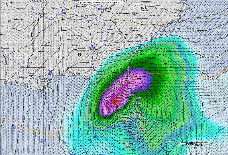
Hurricane Milton Update
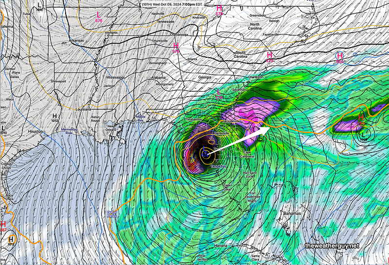
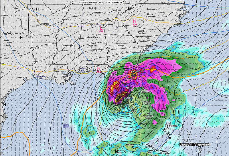
Posted Sunday 10/06/24 @ 3:14 PM —The latest model guidance is forecasting a major hurricane for the west coast of Florida. There is some question about the timing and exact point of landfall, but the intensity looks to be at least a Category 3 or likely a Category 4 storm.
The latest GFS has a northern track, further north than several other models—
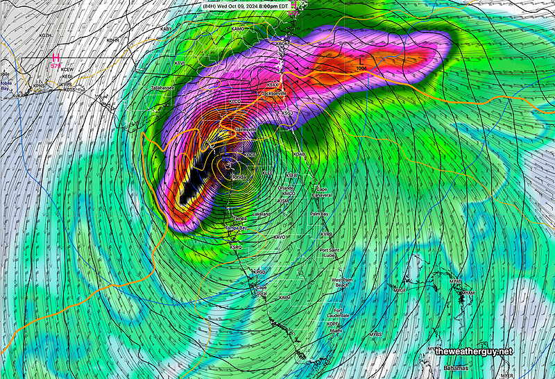
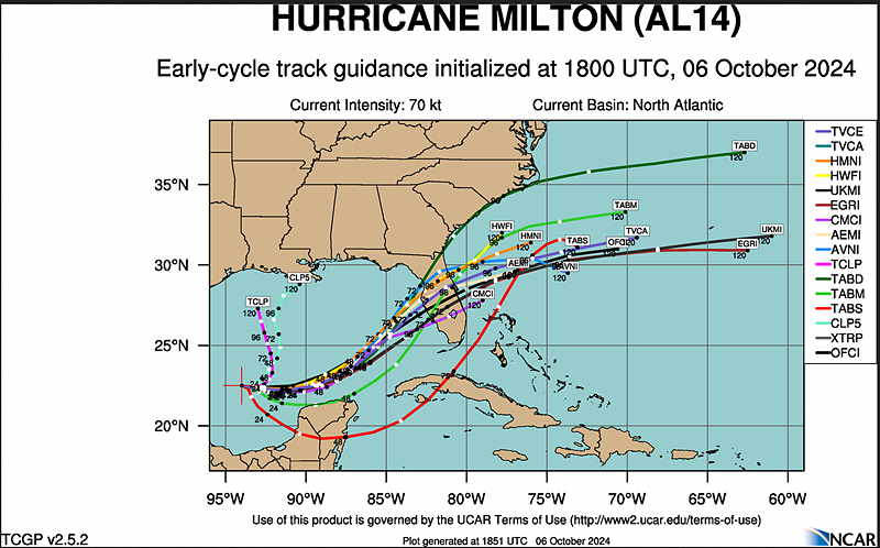
Milton looks to be a fast moving but dangerous storm.
Sunday Forecast Update
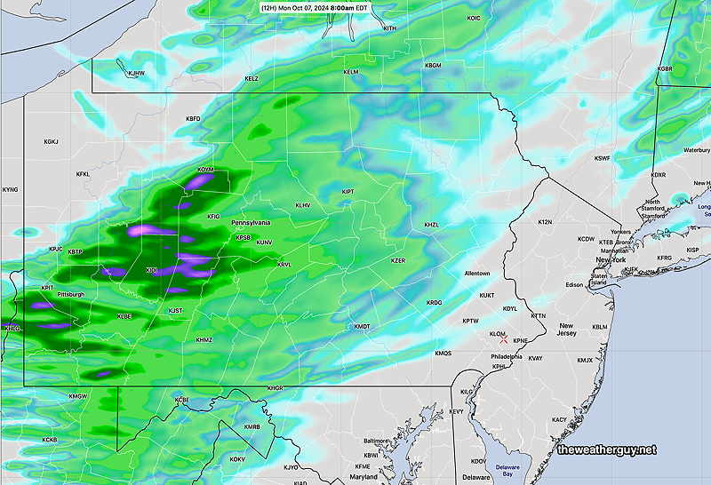
Posted Sunday 10/06/24 @ 8:55 AM — While some of the lower resolution global models (GFS, ECMWF) still show a line of showers after midnight in our area from a cold front, the higher resolution models (HRRR, RRFS, NAM-NEST, HRDPS,) show very spotty rainfall with low or no rain accumulations in many areas.
Here’s the NAM-NEST forecast total rainfall —
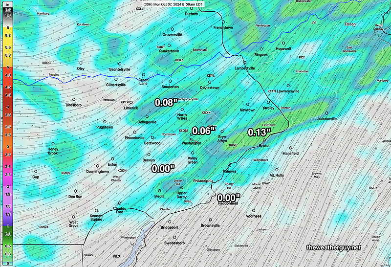
Here’s the HRRR total rainfall forecast for tonight—

Either way, not much in the way of rainfall. The reasons are discussed below.
Hurricane Milton
Posted Saturday 10/05/24 @ 7:55 PM — A new tropical system has developed in the Gulf, likely to intensify and be named Hurricane Milton.
Those following this blog know that the ECMWF-AIFS has been forecasting this development and track for days. While I hadn’t posted the German ICON model, it too was an early forecaster of this system.
The several runs of the GFS have jumped on board with a forecast track that would affect areas recently hurt by Hurricane Helene.
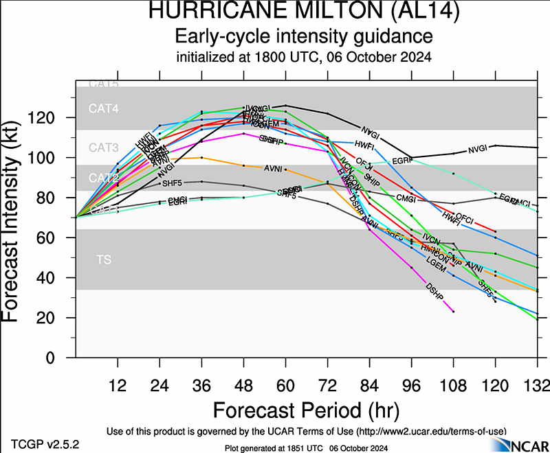
Here’s the latest GFS with a central pressure of 954 mb, likely at least a Category 2 , possibly Category 3 storm —
The latest German ICON is further south and slower —
This morning’s ECMWF is a bit further south (as is the Canadian Global) with this storm—
The model that has been forecasting this for almost a week, the artificial intelligence/machine learning model has a track further south and a bit faster with landfall—
Hurricane Tracks often change and I expect changes in these model forecasts. But a strong system to affect parts of Florida looks high probability.
Update Sat 10/05 5:38 PM — Watching the Phillies game and “doing the weather”. The latest models do show a hurricane at least Category 2 moving into central Florida from the western Gulf. More details after the game
Originally Posted Sat @ 12:27 PM — —Beautiful weather for this weekend. The chance of rain has significantly diminished for our area for Sunday night.
Why are we not getting any rain?
People have asked why we’re not getting rain. The reason is a persistent lower and upper level high pressure system, that both blocks the rainfall and results in downward vertical motion in our area.
More importantly, this persistent high pressure has caused the jet stream to be to our north, resulting in upper level downward motion unfavorable for rain in our area. My conjecture is the global warming has caused the resulting warmer air mass to be larger resulting in a more northern jet flow, along with a smaller air mass of colder air to our north.
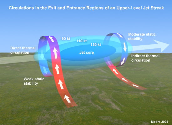
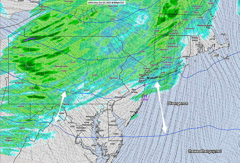
As a result, we’re in the in an area of both upper air divergence and the we’re also in the “right exit region” of the jet streak.
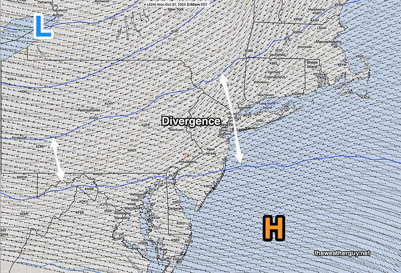
Additionally, we’re located south of the jet streak, specifically in the right exit region, also resulting in downward motion unfavorable for rain in our area—
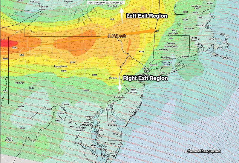
Here’s the HRRR predicted total rainfall for Sunday night. The upper level divergence and position of the exit regions affect our rainfall —
I’ll be updating this page about the the likely hurricane to affect Florida later today. (It appears the AI model of the ECMWF has been the first to identify the likely storm. I should note that the German ICON model has been forecasting something similar for several days. )
Check back later today.