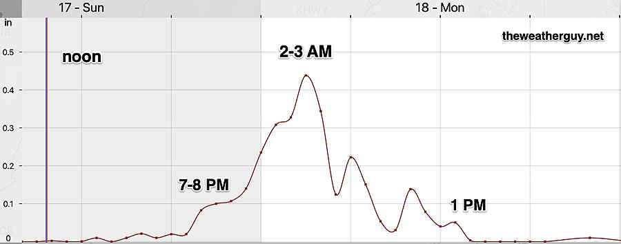
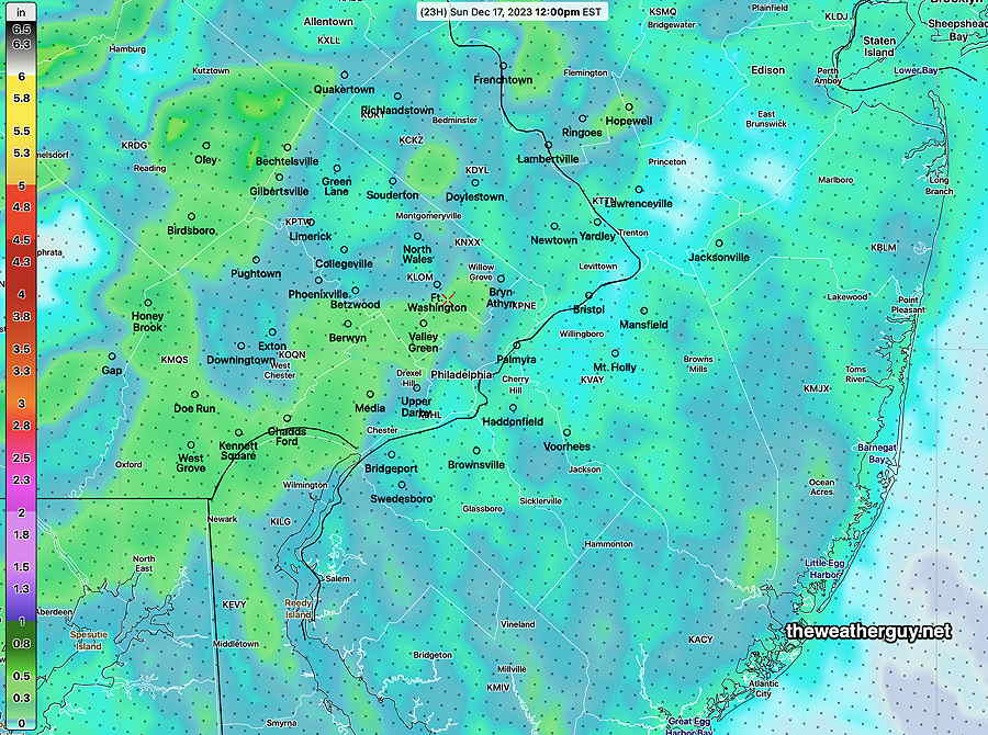
Posted Sunday 12/17 @ 3:10 PM — It’s looking like 3-4 inches of rain (even 5″ in a few spotes just to our west) will fall over a large area, according to the majority of this morning’s models.
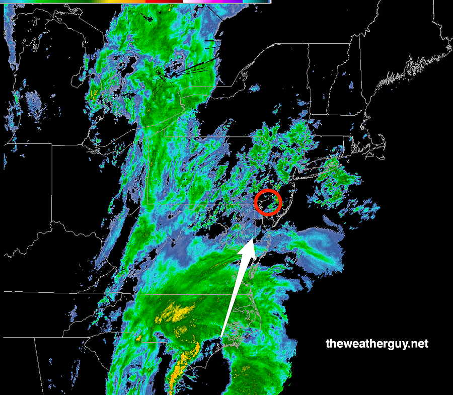
Here’s the 3 PM MRMS radar. The heaviest rain is expected between 1 and 4 AM —
MRMS radar at 3 PM Sunday.
Sunday Storm Update
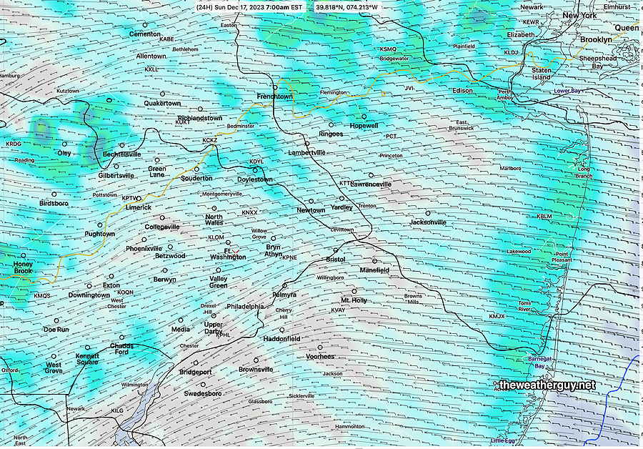
Posted Sunday 12/17 @ 9:33 AM — After reviewing the latest model guidance, the forecast remains pretty much intact. Very light drizzle of increasing intensity is visible on radar moving up from the Cape May area. A gradual increase in dampness as the morning proceeds.
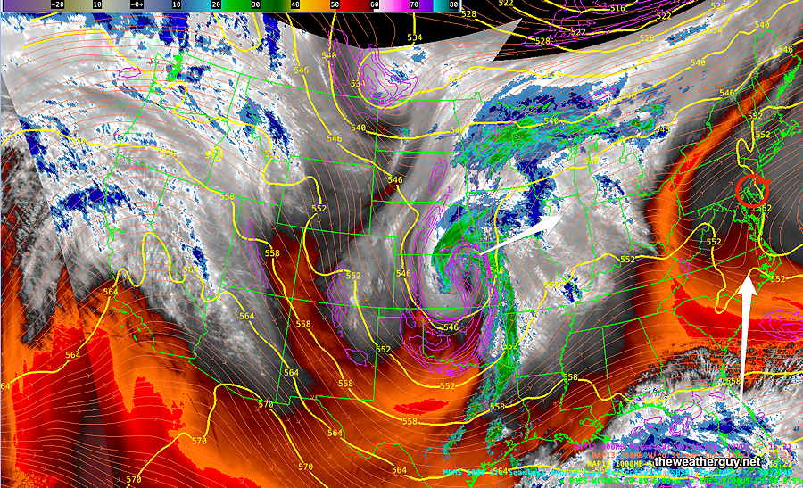
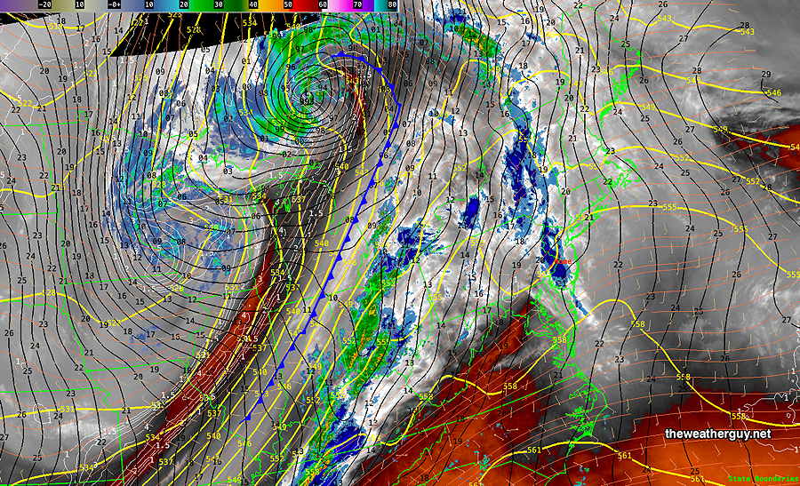
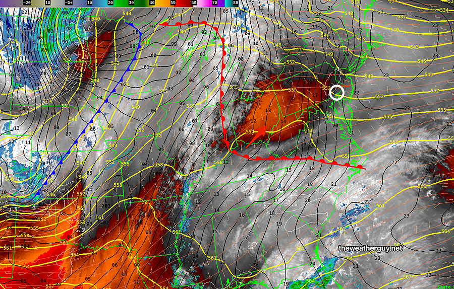
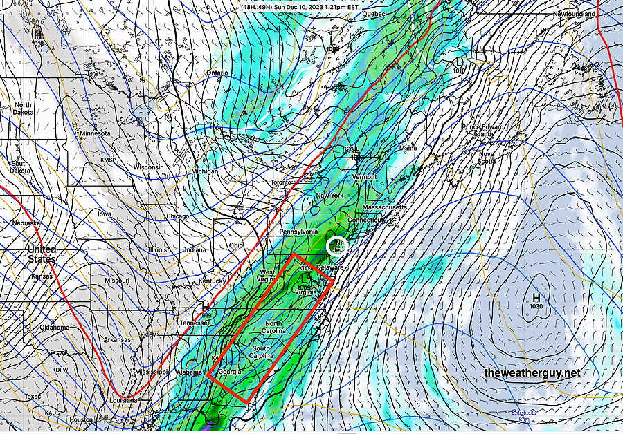
The current setup, via satellite water vapor imagery—
Current satellite water vapor image with superimposed RAP model 500-1000 mb thickness lines (yellow), jet level wind streamlines (orange contour-arrows) potential vorticity (fine violet contours) and superimposed MRMS radar. The main storm is far to our south moving almost directly towards us. (Click on image for a larger view.)
Here are the salient points regarding this storm—
light scattered drizzle, increasing late afternoon
heaviest rain 2-3 AM tonight
rain taper late Monday morning ends after 1-2 PM Monday
highest winds after midnight and especially 2-3 AM into Monday morning. Wind gusts 40 mph with some models showing 50mph.
Snow flurries, especially north and west daybreak Tuesday. Possibly a coating northwestern suburbs.
Here’s the hourly forecast rain rate in inches per hour (NBM model)—
NBM Precipitation rate (Blue Bell) in inches/hour. Greatest rainfall intensity (and winds) 2-3 AM (Click on image for a larger view.)
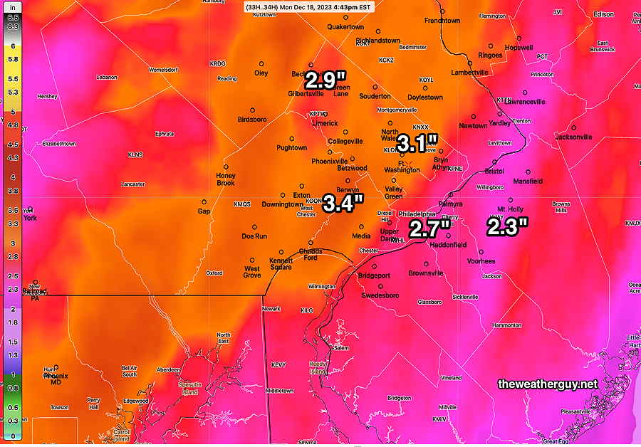
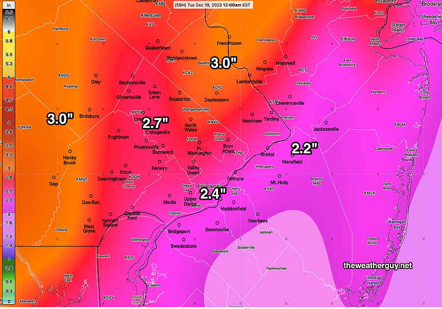
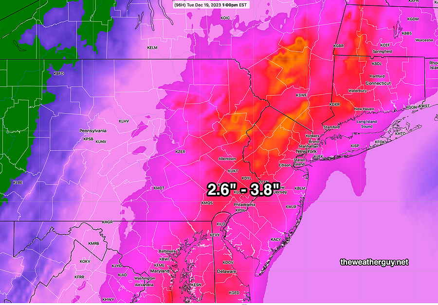
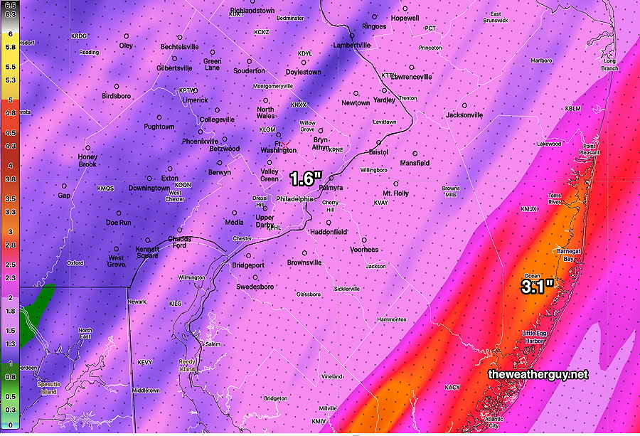
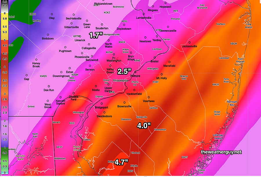
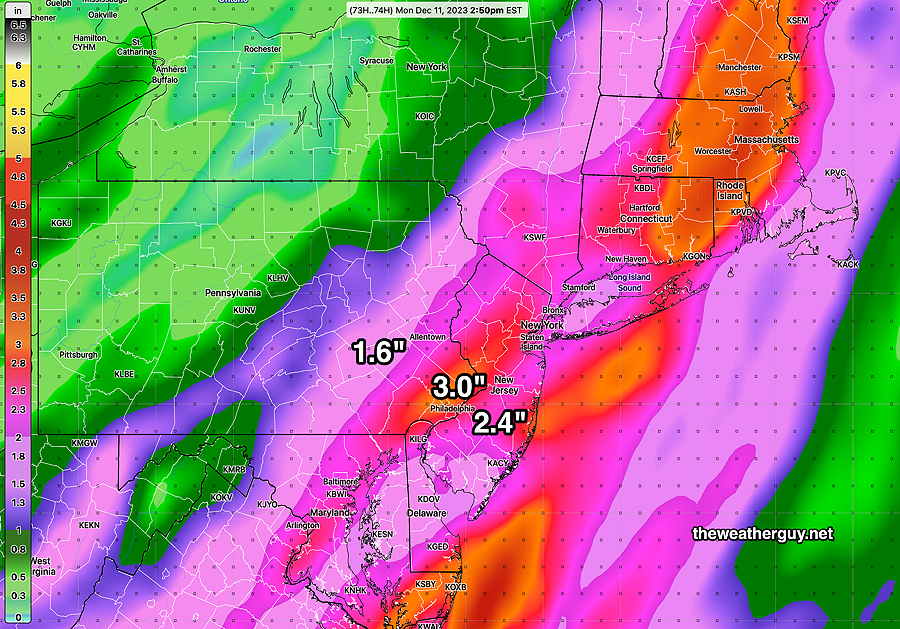
Total Rainfall expected—
Today’s 12z NBM total precipitation forecast. Some models show areas of 4″+ Click on image for a larger view.)
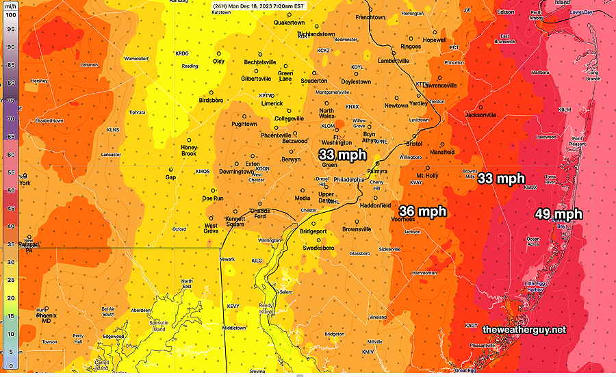
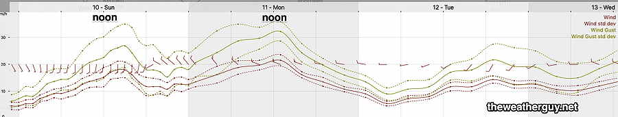
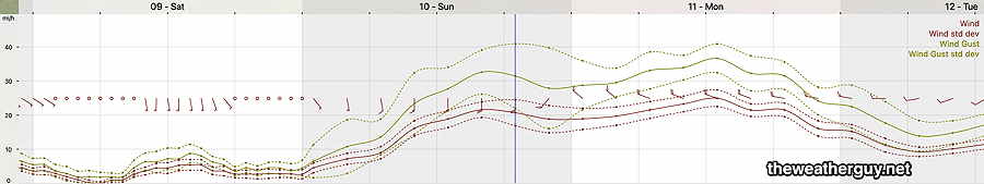
Wind gusts—
Sunday Forecast Update
Posted Saturday 12/16 @ 4:55 PM — The high cloud cover today was less than forecast and the NAM-NEST was one of the few models that got this right today (but discounted by me) .
The NAM-NEST continues to forecast showers and drizzle as early as the early to mid morning Sunday, and because of its accuracy today, I’m going with it for Sunday. It’s supported somewhat by the latest ECMWF and to some extent, the latest GFS, but the rainfall it’s predicting early is quite enhanced—
NAM-NEST shows showers and drizzle starting before daybreak and rainfall by noon Sunday is considerably more than several other models. Nonetheless, I’m going with it, based on its performance today. (Click on image for a larger view.)
The heavier rain starts between 5 PM and 7 PM Sunday evening. At that time, the main storm is still in South Carolina moving north. By midnight, wind gusts increase to 40 mph.
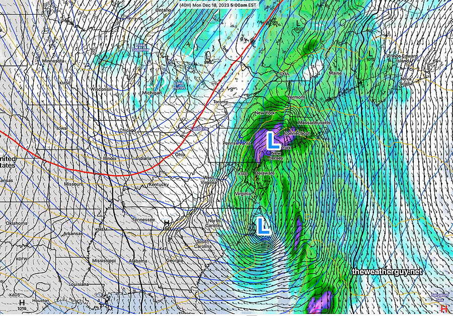
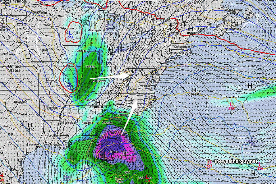
By 5 AM Monday morning, the low is an elongated two-center system right over our area—
Latest GFS (18z) shows a two center elongated low at 5 AM Monday. (Click on image for a larger view.)
The rain tapers off after noontime Monday. Total rainfall (GFS) —
Today’s latest GFS (18z) shows total rainfall expected. (Click on image for a larger view.)
Forecast Update
Posted Saturday 12/16 @ 9:18 AM — The forecast is on track for today, Saturday, with increasing high cloudiness, especially by late afternoon.
The general trend of last night’s models continue with the rain of the main low pressure reaching us during the evening hours, and with light scattered showers and drizzle during the day Sunday.
The NAM-NEST is particularly aggressive (maybe too aggressive?) with the light rain/drizzle during the day Sunday —
The latest NAM-NEST has light showers and drizzle, even Sunday morning. Possible, but maybe too soon. (Click on image for a larger view.)
One trend I’m watching (hinted only slightly by the GFS and ECMWF) is a more westward track of the low, with the heaviest rain west of the city into central PA.
I’m particularly interested in this trend, since the still experimental RRFS model (now at version 0.7.7) shows a considerable westward track of the storm. (It’s more than likely that the RRFS is not ready for prime time, but I’m curious to see if it provides any insights. You can see the ongoing development notes of the RRFS model here. )
I’ll update later this afternoon with the latest.
Previously Posted Fri 6:42 PM —
An impulse in the middle of the US will merge with another over Florida and move up towards us on Sunday, resulting in a powerful storm directly over us. Here’s the current water vapor image showing the setup—
Current satellite water vapor image (Friday afternoon) with superimposed RAP model 500-1000 mb thickness lines (yellow), jet level wind streamlines (orange contour-arrows) potential vorticity (fine violet contours) and superimposed MRMS radar. (Click on image for a larger view.)
A deep and significant storm will be the result. The NAEFS which combines the GEFS and Canadian GEPS shows the sequence—
NAEFS forecast Sat night–> Sunday night–> Monday night. (Click on image for a larger view.) By Tuesday, we’ll have a closed upper low with very cold air over our area. (Click on image for a larger view.)
High winds and heavy rains expected.
Saturday
Sunshine through high level cirrus cloudiness. The high level cloudiness thickens later in the day. Light winds.
High temperature 53º ( NBM model— location Blue Bell, PA) High temperature 54º ( NBM model— location Philadelphia, PA) average to low level of uncertainty ± 1.5º
Previously Posted Fri 6:42 PM —
Sunday
Cloudy. Scattered light rain in the morning, becomes more widespread and heavier by 2-3 PM. Light winds, becoming windy in the evening.
High temperature 56º ( NBM model— location Blue Bell, PA) High temperature 58º ( NBM model— location Philadelphia, PA) average level of uncertainty ± 2.5º
Rain, very heavy, Sunday night into Monday morning. VERY WINDY!
By late Monday, becoming quite cold and windy. Possibly some snow flurries.
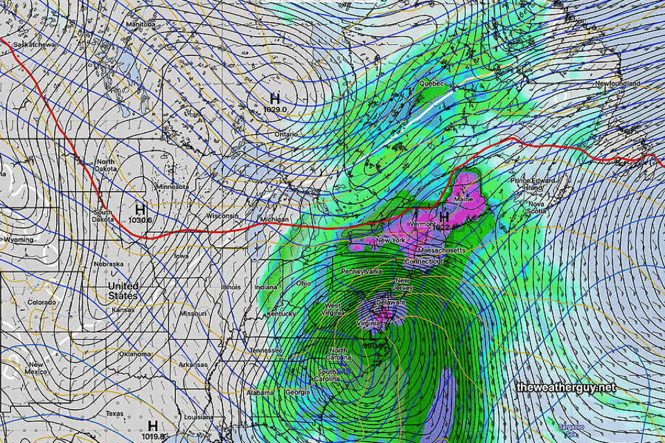
Total Rainfall—
NBM model total rainfall through late Monday. (Click on image for a larger view.)
Posted Thursday 12/14 @ 8:08 PM — Significant changes in the model forecasts continue to occur with the speed, timing and path of the storm. Additionally, large changes in the amount of cold air moving southward have showed up in recent model runs.
Here’s the latest NAEFS forecast compared to yesterday’s NAEFS forecast for 7 AM Monday—
NAEFS forecasts for 7 AM Monday from yesterday and today combined into a gif. Same model, same time frame, very different placement. Notice the greatly amplified jet flow, as captured by the sharped dip in the 540 thickness line. (Click on image for a larger view.)
Meanwhile the latest GFS is more inland and much faster at 7 AM Monday with the system already in NY State—
Thursday’s 18z GFS shows the storm center in NY State at 7 AM Monda (Click on image for a larger view.)
So things are not nailed down with this system, especially since the GFS is so different than its related ensemble forecast.
One trend that is present is an earlier start of the rain on Sunday, now likely sometime in the morning. Increasing rainfall in the afternoon.
Friday and Saturday look great with temps in the low 50s. Some high clouds move in Saturday afternoon.
Interesting Weather Sunday -Tuesday
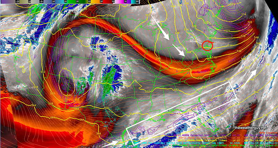
Posted Thursday 12/14 @ 9:41 AM — A very active southern jet stream will spawn low pressure over Florida.
Here’s the current setup as seen via satellite with superimposed RAP model —
Current satellite water vapor image with superimposed RAP model 500-1000 mb thickness lines (yellow), jet level wind streamlines (orange contour-arrows) potential vorticity (fine violet contours) and superimposed MRMS radar. Note the violet contours showing potential vorticity areas, areas where low pressure will develop. (Click on image for a larger view.)
There’s been uncertainty with the development and track of the low. What had been expected to be a coastal low now appears to be more of an inland storm, with plenty of rain and wind, beginning here Sunday.
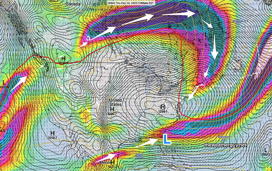
For several days, the low was expected to be coastal and linger. Now, it’s expected to be inland, move north faster, and then a second low will develop along the coast. —
Three frames of the NAEFS assembled as a gif, shows a likely path and development of this storm. Note the last frame shows a second low off the North Carolina coast. The red 540 thickness line captures the influx of cold air behind the first system. (Click on image for a larger view.)
With a faster moving system, rain will begin around noontime on Sunday and continue through much of Monday. More showers (or even snow showers) possible Tuesday.
The trends shows the influx of cold air behind the first system, a new trend with this storm. There won’t be enough cold air with the main system for snow here, but snow showers possible with the second system on Tuesday.
This is a complex system and the final forecast is not complete. (is it ever?) Stay tuned.
Coastal Storm Early Next Week
Posted Wednesday 12/13 @ 10:21 AM — As discussed yesterday, we’ll be under the influence of a cold upper trough Thursday that transitions to a warm upper ridge as early as Friday into Saturday.
An interesting setup for late Sunday through at least Tuesday as a southern jet stream spawns a low over Florida that ends up somewhere in the western Atlantic and possibly moves up the coast (GFS). Other models have different tracks and speeds with this system. The NAEFS has the storm lingering through much of early next week, which, while possible, is unlikely.
The current setup for next week depicts a pattern that does NOT favor snow. In colder winters this would be different.
Todays’s 06z NAEFS forecast for next Monday morning, showing a deep low off the SC coast. There is high uncertainty with the path and speed of this system, as well as the amount of cold air that will move either south or southeast. The color shaded areas are jet stream level wind speeds, the red contour is the 500-1000mb 540 thickness line and the black contours are surface pressure isobars. (Click on image for a larger view.)
With the (red) 540 thickness line so far to our north, snow isn’t possible in our area from this storm. Should high pressure push further southward from Canada, things might change. No model is showing that now.
An interesting situation. Stay tuned.
Philly Weather Outlook
Posted Tuesday 12/12 @ 5:51 PM — High pressure will continue to provide fair skies and cold temperatures through Saturday. A weak front will replenish the cold air Thursday.
The jet stream configuration continues to be strange for December, with the northern jet well into Canada. My discussion of what’s happening is in the caption of the graphic below—
Tuesday’s 12z NAEFS forecast for late Thursday shows the jet winds (shaded by speed) well into Canada, instead of dropping down into the US as is the old normal. The trough (dip in the jet) over the Northeastern US will continue to filter some cold air into our area. The southern jet is crossing Florida and is expected to spawn a major rainstorm (Blue L) in Florida that may become a Nor’easter. There’s quite a bit of spread (uncertainty) with the path of the potential nor’easter, but even if it stays close to the coast (GFS), there is not enough cold air here for snow; it will be rain late Sunday or Monday.
“There’s not enough cold air here for snow.”
-Likely to become the defining phrase of this winter.
Previously Posted Mon 11:17 AM —
We’ll start with a forecast review:
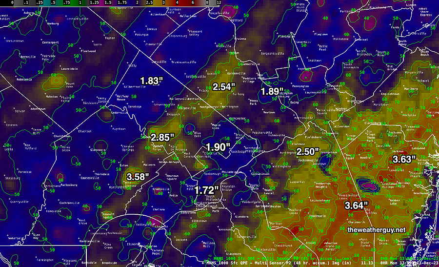
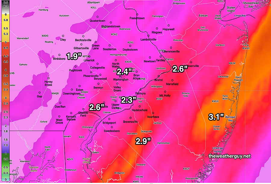
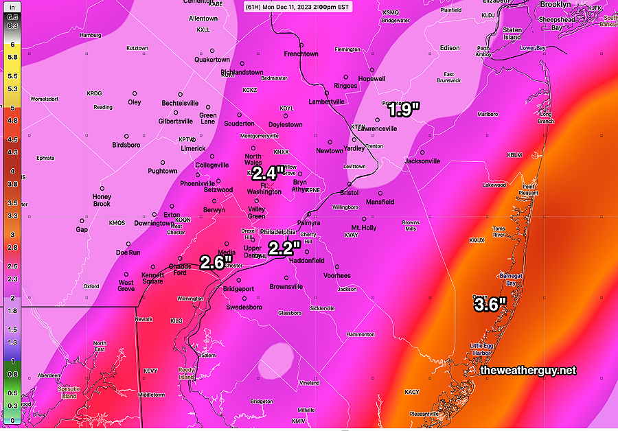
Mon 9:47 AM Forecast Review — We had the rain, as forecast, but the very strong winds forecast never really materialized. Here’s the MRMS estimate of the rainfall we received—
MRMS based total rainfall received (radar and measured rain gauge based) (Click on image for a larger view.)
If we go back to my previous postings for the weekend, the general range of rainfall, 2-3+ inches is correct, but no model consistently nailed the exact placement of the heaviest rain; most had the heaviest rain in NJ, but those that did missed the other band of heavy rain just west of the city.
This is entirely analogous to why it’s impossible to nail down the heaviest banding of snow storms; it’s similar model precipitation physics but snow leaves its forensic remains in plain sight; with rain, few people know if they received 1.8 inches or 3. Not so with snow. Not to mention the multiplier factor of typically 1:11 for snow.
The Coming Week
As for the week’s weather, look for dry conditions through the week (and likely through the weekend and much of next week)! Not much happening. As mentioned in my updated Winter Outlook, I don’t see any snow here for Christmas at this time.
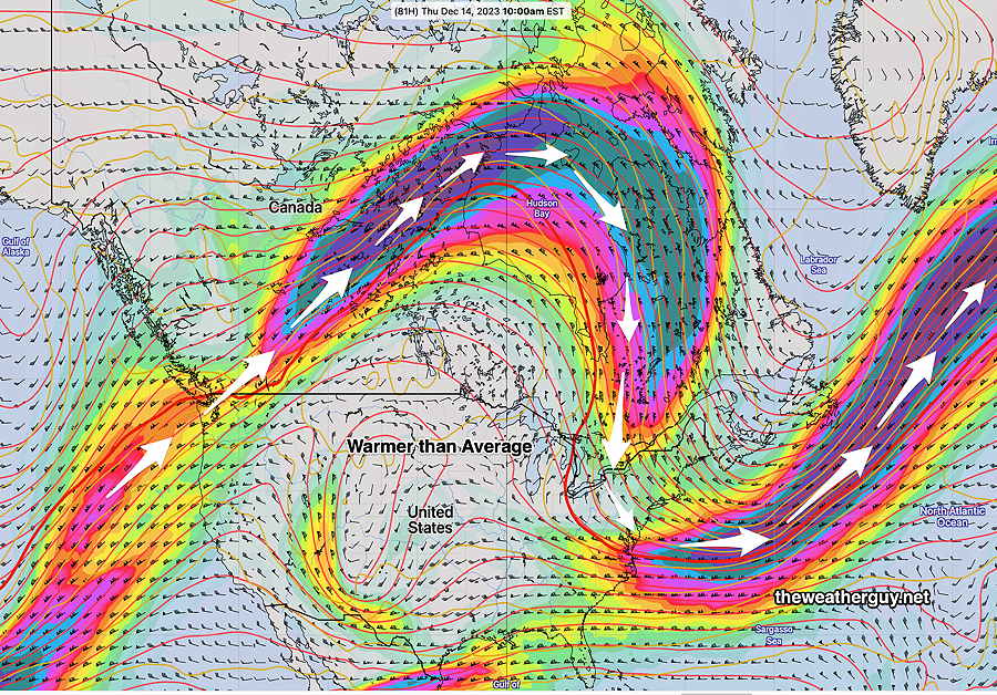
I can’t think of the last time I saw the jet stream so far north into Canada in December—
Today’s 06z NAEFS jet stream winds (with red 540 thickness line) Thursday morning. Large warm ridge in much of the country. We’ll be in a somewhat colder trough area. (Click on image for a larger view.)
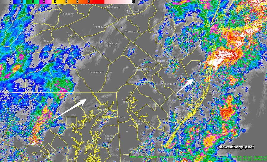
Posted Sunday 12/10 @ 3:23 PM — There’s been very heavy rain in NJ since around noontime and it’s moving off to the northeast. Philadelphia and its surrounding suburbs have missed some of the heaviest rain, so far.
MRMS radar/rain gauge current precipitation rate at 3:18 PM Sunday. Another area of intense activity is lining up to the west of Lancaster County and will be here by about 7-9 PM.
Is that it?
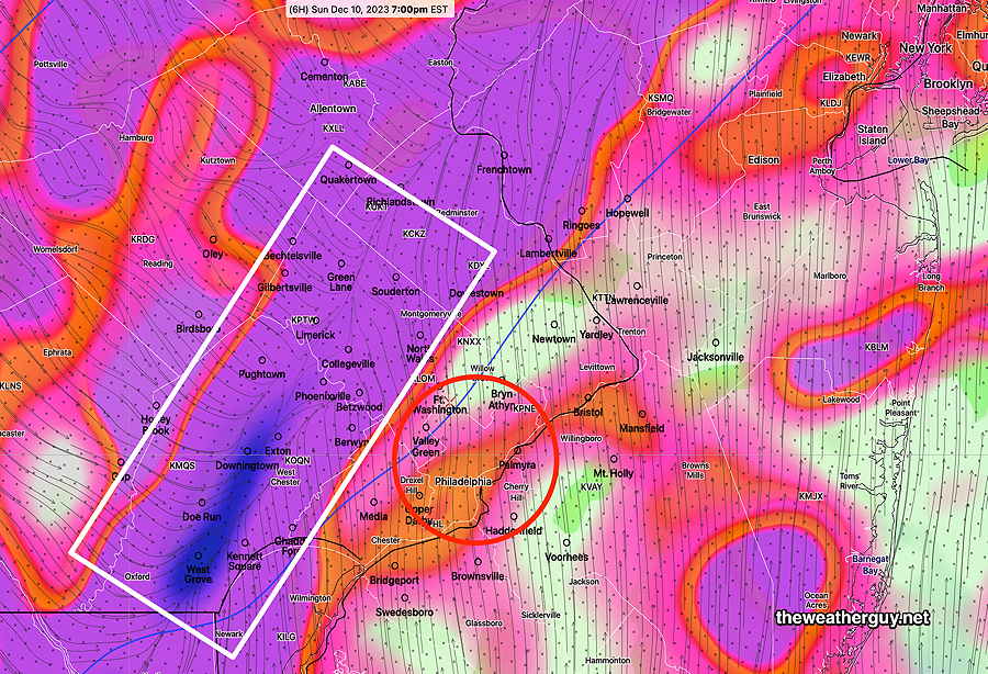
No. I just ran the latest HRRR (in what I call ‘summer-parameter mode’) and it shows huge dynamics as the front approaches between 6 PM and 9 PM as the front slowly moves through —
Today’s latest HRRR shows extremely strong upward vertical motion (white box) in the western suburbs at 7 PM. Expect heavy rain and high winds. Thunderstorms possible, especially east into NJ after 7 PM. Notice the convergence of the wind stream lines inside the white box. (Click on image for a larger view.)
Precipitation may last through 6-7 AM Monday morning
Sunday Storm Update
Posted Sunday 12/10 @ 10:56 AM — This morning’s models are in. It’s almost funny…the HRDPS has shifted to have the main rain axis eastward into NJ, similar to previous runs of the HRRR. The new HRRR looks similar to last night’s HRDPS with the main axis of rain just west of Philadelphia.
The NAM-NEST which was the same as last night’s HRDPS now has it’s axis well west of the city, in a similar placement to the HRRR.
(Go figure!This is why snow storm forecast snow totals are always impossible to pin down.)
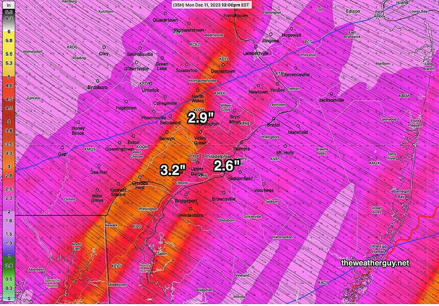
Here’s this morning’s 12z NBM which is designed to blend these differences together—
12z NBM forecast for total rainfall for this storm (Click on image for a larger view.)
One more thing— the latest NBM wind gust forecast is for wind gusts to be in the 30-38 mph range ( but with an sd ± 15 mph).
Posted Sunday 12/10 @ 8:35 AM — The onset of the rain now appears to be between 11 AM and 12 PM in the immediate Philadelphia area, earlier to our west. Precipitation totals have been reduced in several models, with the heaviest rainfall near the shore. However, I’m sticking with the HRDPS forecast —
Today’s 06z HRDPS rainfall totals by Monday morning.
Some snow flurries are possible north and west of the city Monday morning. No accumulation.
Wind Gusts: 35-40 mph Sunday evening. Stronger gusts to 50 mph Monday morning towards noon.
Sunday Storm Update
Posted Saturday 12/09 @ 5:46 PM — Current conditions at 6 PM—
Current satellite water vapor image 6 PM with superimposed RAP model 500-1000 mb thickness lines (yellow), Mean Sea Level Pressure isobars (black contours) potential vorticity (fine white contours) with superimposed MRMS RADAR. (Click on image for a larger view.)
It appears that rain will move in about 9 – 11 AM from the south and west on Sunday. It will start light and become heavier by 2 PM. For the rest Sunday and Sunday night, rain heavy at times and very windy. Rain should end by 6 AM Monday for most of the area.
As is always the case, there are differences in the model forecasts regarding banding and the placement of the heaviest rain on Sunday. Examples—
Today’s 18z HRRR total rainfall. (Click on image for a larger view.)18z HRDPS total rainfall Sunday into early Monday. (Click on image for a larger view.)
It will be quite windy, but the wind forecasts are not as extreme as earlier forecasts—
Todays 18z NBM wind meteogram for location Wings Field, Blue Bell PA (Click on image for a larger view.)
Posted Saturday 12/09 @ 9:05 AM — The fog is expected to lift before noontime. There’s a range of model guidance regarding cloud cover in the afternoon. The best bet is for some breaks of sunshine through high cirrus clouds after noontime with an increase in cloudiness again around 4 PM.
High Temperatures: 51º Blue Bell 52º Philadelphia (uncertainty high due to cloud cover uncertainty ± 3.5-4.0º)
For Sunday: Rain moves in about 8 AM from the west. Some of the extreme wind speed forecasts have decreased in intensity to the 30-40 mph range. Still 2-3 inches of rain forecast, but with some shifts in the placement of the bands of heavier rain to NJ.
Latest GFS forecast total rainfall (06z) by Monday morning. (Click on image for a larger view.)
Update Fri 12/08 11:13 PM — Based on tonight’s model guidance, it’s unclear how much sun we’ll see on Saturday afternoon, after the fog mist and light drizzle lifts just before noon. Considerable cloudiness is more likely than sunshine.
A warm front will slowly move through early Saturday. Previous model runs just had clouds and fog with this front, but the latest NAM-NEST and HRDPS show light showers drizzle and fog Saturday morning.
Current satellite water vapor image (Friday afternoon) with superimposed RAP model 500-1000 mb thickness lines (yellow), Mean Sea Level Pressure isobars (black contours) potential vorticity (fine white contours) with superimposed MRMS RADAR. A warm front will move north Saturday. (Click on image for a larger view.)
An approaching cold front will have a low pressure wave develop along the front on Sunday afternoon. Heavy rain and strong wind gusts are expected with this front and low pressure system Sunday afternoon into the overnight hours of early Monday. The system is approaching faster than previously forecast, but may bog down over our area with several areas of low pressure developing.
Here’s the GFS forecast for early Sunday afternoon—
Latest GFS forecast (18z Friday) showing cold area of low pressure development along this very sharp cold front early Sunday afternoon. (Click on image for a larger view.)
Saturday
Low clouds, fog, drizzle and showers Saturday morning. Some clearing and sunshine after 12 PM Saturday afternoon. Light winds.
High temperature 52º ( NBM model— location Blue Bell, PA) High temperature 51º ( NBM model— location Philadelphia, PA) larger than usual uncertainty with standard deviation ± 3.5º
Sunday
The latest shows showers moving in around daybreak and rain heavy at times during the day, becoming heavier towards evening. Rain lasts through about 4-5 AM Monday morning. Rain will be heavy—
Latest GFS total rainfall forecast for Sunday. (Click on image for a larger view.)
High temperature 62º ( NBM model— location Blue Bell, PA) High temperature 64º ( NBM model— location Philadelphia, PA) uncertainty ± 2.1º
High winds through much of Monday!
NBM wind meteogram for location KLOM Blue Bell, PA (Click on image for a larger view.)