PHILLY WEEKEND WEATHER FORECAST

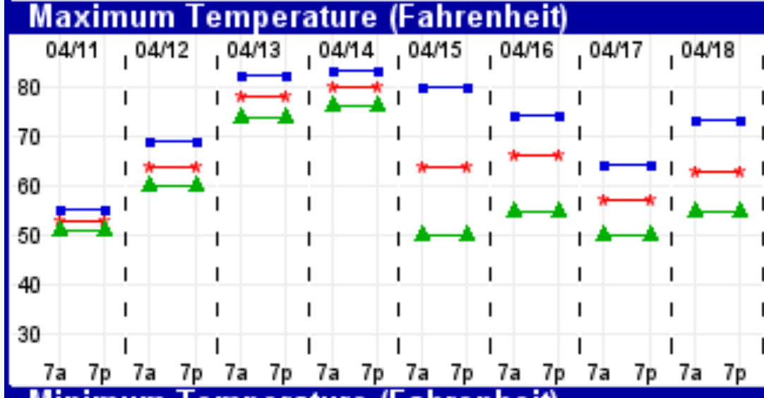
The southwesterly flow of above average temperatures will be with us on Saturday, with mostly sunny skies and temperature highs  of 83-85..

Some cloudiness moves in late Saturday afternoon as a cold front drops down  from the north.

Winds become easterly Saturday night and clouds and  scattered light showers with drizzle are possible Sunday morning although the heavier rains don’t move in until later in the afternoon on Sunday.

There remains uncertainty about high temperatures on Sunday. The Model Output statistics have highs around 58, but the experimental models continue to show a wide range with highs likely being much cooler. (48-50 is possible)  It becomes windy during the day.

Heavy rains and windy Sunday night into early Monday morning.

WARM WEATHER FOR PHILLY-FINALLY!

It’s been well-advertised that warmer than average temperatures will finally be felt in the Philadelphia area.

The experimental statistical model statistics (EKDMOS) has a temp of about 80, with the possibility of higher (or lower):

Experimental temperature forescast for Philadelphia
Experimental MOS forecast


By the way, the National Blend of Models (NBM) shows high temperatures of 76 (Friday) and 77 (Saturday).

You can see that on Sunday, 4/15, the range of temperature possibilities is quite large indicating high uncertainty for temperature highs on Sunday.

There’s a high chance of rain on Sunday, especially Sunday afternoon and evening, into Monday.   Some of the rain may be very heavy.


Weather… and Other Things 'Up in the Air'