Broad Street Run Forecast Update- We had a little more sunshine than predicted this morning. I’m always glad to be wrong about this. Cloudiness did move in during the afternoon.
Some showers will be moving in Saturday evening.
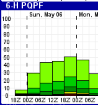
For tomorrow, Sunday, the models continue with a break in precipitation during the morning hours for the Broad Street Run. Minimal precipitation expected in the morning hours (QPF< 0.01 inches water) but rain returns after 2 PM.
It will be cloudy, cool with high temperatures in the mid 60s and a breezy north to northeasterly wind.
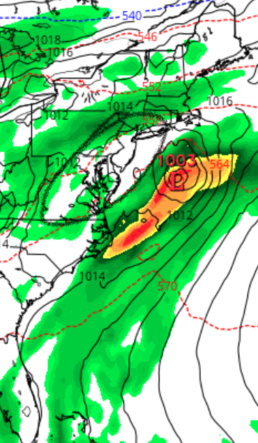
Experimental GFS model- Accumulated precipitation during the morning hours 8AM to 2PM Sunday. Most models keep the immediate PHL fairly dry in the morning hours.
While the operational models (NAMGFS) maintain dry conditions in the morning, the statistical models maintain a chance of light precipitation during the morning. (12Z-18Z)
Ensemble Kernal Density Model Output Statistics (Experimental)
A frontal boundary will pass through our area this evening. Some light showers are possible with the frontal passage.
The front is expected to stall to our south on Saturday, Cloudy conditions are expected, but most of Saturday should be dry. High mid 70s.
Showers develop during the late afternoon or evening Saturday as winds shift to the east and some over-running moisture develops across the stalled front to our south.
On Sunday, as high pressure builds to our north, an easterly flow will bring damp conditions and intermittent drizzle on Sunday. Low level cloudiness and cooler temperatures in the 60s are expected.
Confidence in the degree of cloudiness and the amount of precipitation on Sunday in a bit below average. There are large differences between the GFS and NAM QPF forecasts.
Experimental GFS forecast Sunday afternoon shows a gap in the precipitation shield in our area.