THIS WEEK’S WEATHER

#Philadelphia #weather #PAwx

Thu 8:14 AM —Forecast Review —Yesterday’s storms came through between 10 PM-2 AM, later than originally forecast in the morning, but the afternoon update seemed to be on target.

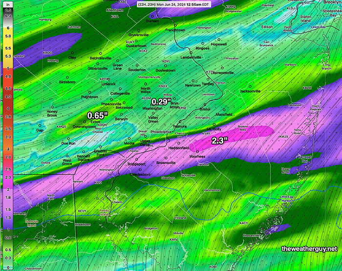
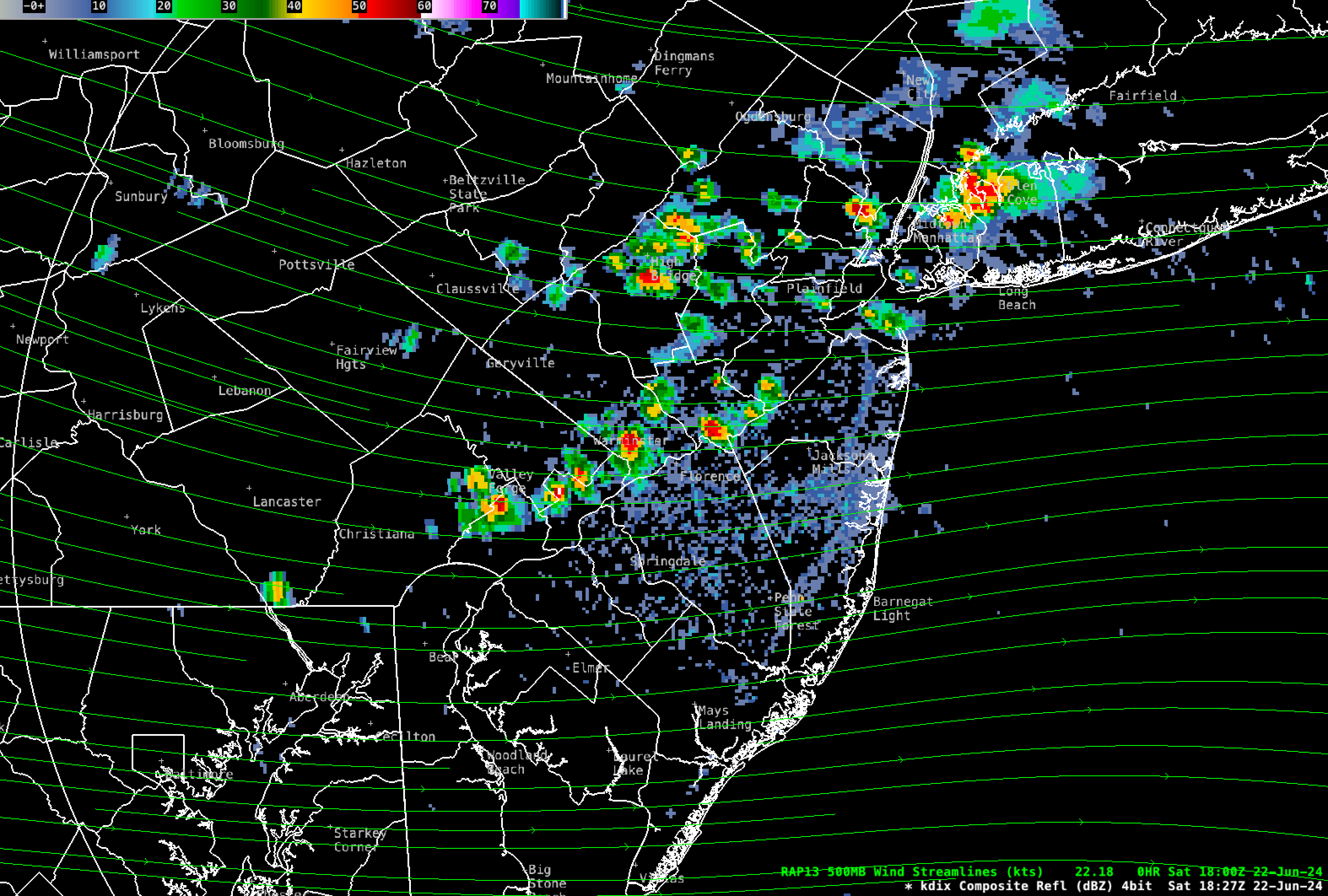
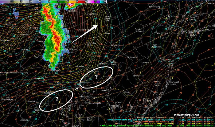
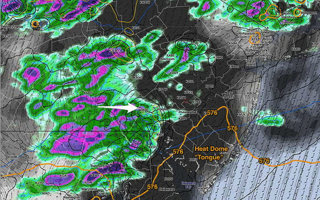
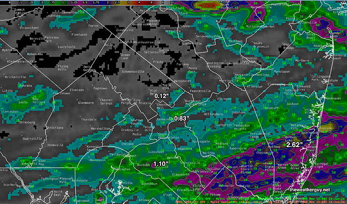
The axis of heavier rainfall was nowhere near where it had been forecast. Some areas received a good soaking, other areas had little rainfall.

Here’s the MRSMS summary—

MRMS rain-gauge measured rainfall combined with rain-guage calibrated and interpolated radar-based summary of ACTUAL RAINFALL received. Color shading is in inches. Line contour numbers are in mm. (25.4 mm= 1 inch)      (Click on image for a larger view.)

Update

Posted Wednesday 06/26/24 @ 5:52 PM — The latest NBM hasn’t changed significantly, but several of this afternoon’s models have moved the timing of the storms here in the Delaware Valley later, from 10 PM through 2 AM.

At 5:40 PM, things aren’t quite popping.

MRMS radar with RAP model parameters. Nothing happening in the ? areas. (Click on image for a larger view.)

Posted Wednesday 06/26/24 @ 1:32 PM — The 15z NBM includes more of this morning’s models. It’s a little more optimistic about the storms making it into Philadelphia, but then dissipating afterwards. This is consistent with the newest HRDPS.

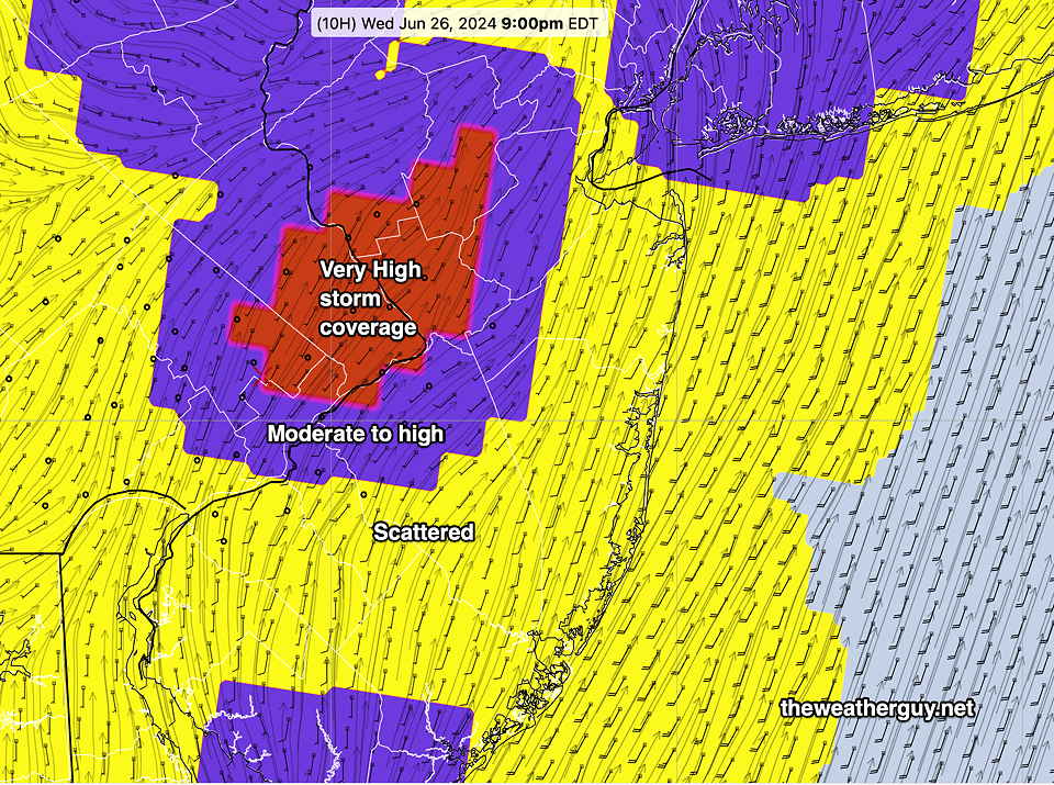
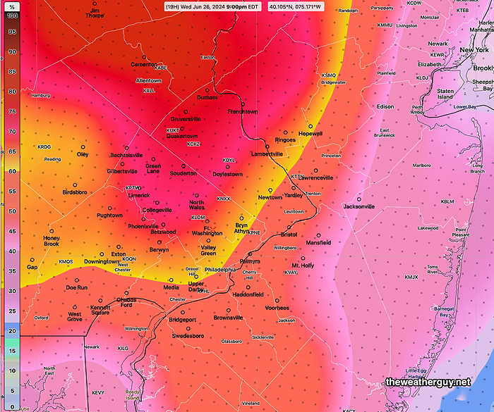
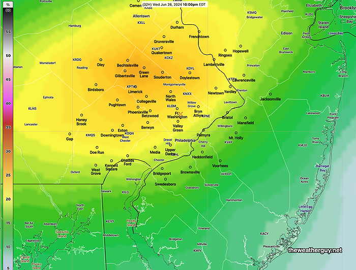
NBM thunderstorm coverage (scale 1-4) at 9 PM —

15z NBM thunderstorm coverage map. This is more optimistic about the heavier rain at least getting into Philadelphia this evening. (Click on image for larger view.)

Posted Wednesday 06/26/24 @ 11:12 AM — While the new HRDPS is not yet available at this hour, this morning’s NOAA models are increasingly trending towards rainfall dissipating as the storms approach and move past Philadelphia. Much needed rain may only reach western suburbs.

NAM-NEST forecast 7 PM and 9 PM showing significant storm dissipation as it moves into unfavorable conditions for convection (thunderstorms) (Click on image for a larger view.)

As we’ve seen, the exact placement is rarely forecast exactly in advance. But a much needed rainfall may not materialize for some areas.

Some of the factors responsible for this thunderstorm dissipating trend are reviewed in my post on dry weather from 2022. Many of the features are the same.


Thunderstorm Update- Wednesday Evening

Posted Wednesday 06/26/24 @ 9:44 AM — A quick update. This morning’s HRRR just became available. As expressed below, I have concern that large “convective inhibition values” (CIN) and low soil moisture feedback mechanisms may adversely affect rainfall totals in the immediate Philadelphia area. The latest HRRR seems to suggest that.

I guess we’ll see tonight.


Posted Wednesday 06/26/24 @ 8:29 AM — In keeping with with my revised probability approach to thunderstorm prediction, I’m going to lean on the probability elements of the HREF, HRDPS and NBM for tonight’s thunderstorm forecast. We can use the rain!

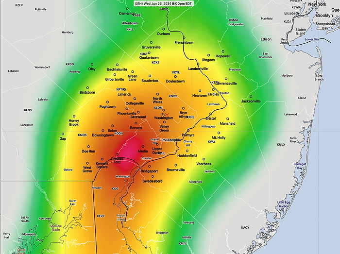
The cold front tonight will trigger showers and thunderstorms. While strong storms are likely in some areas, I would put the severity (hail, high winds) probability as a 1 out of 3 in the Philadelphia area and immediate surrounding counties. The latest HREF shows the areas of greatest rainfall and severity at 9 PM—

HREF hourly probability of strong radar echos at 9 PM Highest probaility of storms is northwest and north of the city. (Click on image for a larger view.)

Showers and thunderstorms will be spotty in areas west of Philadelphia as early as 5-6 PM. The main area of showers and storms moves in between 7 and 10 PM and showers linger into the predawn hours of Thursday.

The NBM shows the highest density of thunderstorms (“thunderstorm coverage”: on a scale of 1-4 ) at 9 PM—

06z NBM thunderstorm coverage at 9 PM Purple is high coverage, yellow is scattered moderate coverage. (Click on image for a larger view.)

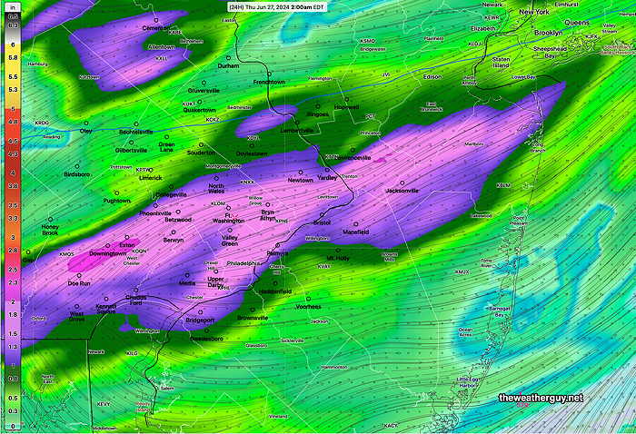
The HRDPS has the following rainfall totals (which is on the high side for the immediate Philadelphia area compared to other models) —

06z HRDPS Total Rainfall. The HRDPS did very well with the last thunderstorm rainfall totals, but many models show less rain than this. (Click on image for a larger view.)

I’m cautiously optimistic that we’ll get some much needed rain tonight, but with many models showing a “tongue” of the heat dome pushing into our area at the beginning of the event, I’m concerned that a wall of convective inhibition (CIN) and low soil moisture in our area may cause the storms to lose intensity as they move from west to east.

I’ll update later if things change.


Thunderstorm Probability Wednesday Evening

Posted Tuesday 06/25/24 @ 8:13 PM —The models have been inconsistent today regarding thunderstorm coverage and probability for Wednesday night ahead of a cold front.

Earlier today, it appeared that any thunderstorms would “hit a wall’ and decrease in intensity as they entered Philadelphia and attempted to move east into NJ. Rainfall totals this morning were forecast to be somewhat on the low side.

The latest models (18z – run 2 PM EDT) have increased the chance of thunderstorms with locally heavy rainfall in the Philadelphia area, with lesser amounts in eastern NJ. Most likely timing in Philadelphia and immediate suburbs is 8 PM to 11 PM Wednesday evening.

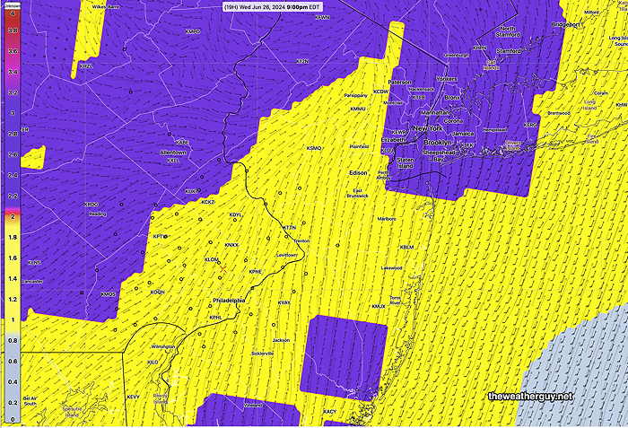
Here’s the current 18z NBM probability of thunderstorms at 10 PM—

NBM 18z forecast thunderstorm probability (Click on image for a larger view.)

The latest Canandian HRDPS shows a maximum at 9 PM—

18z HRDPS thunderstorm Probability (Click on image for a larger view.)

The HRDPS did well with our last frontal passage. Here’s its current total rainfall forecast —

HRDPS total rainfall. Blue-violet is > 1inch. Some areas will again have unimpressive rainfall. (Click on image for a larger view.)

Right now, I’m skeptical about heavy rain here and things will likely change tomorrow. Check back for an update tomorrow morning.

Strong storms are possible in some areas.


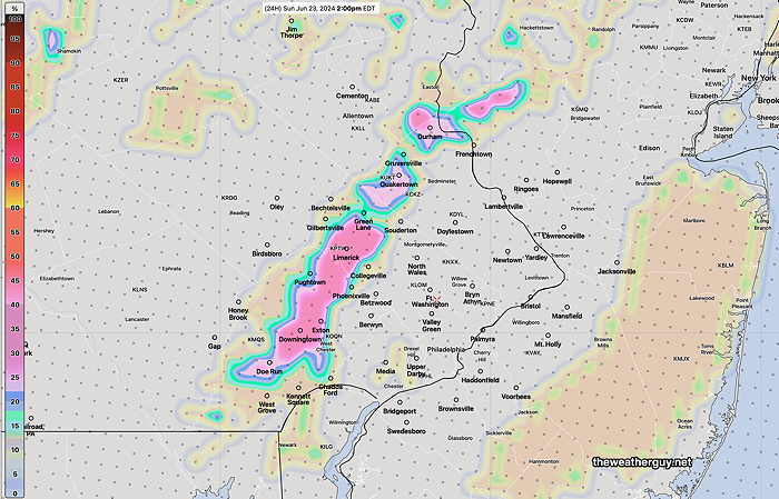
Previously Posted Mon 12:51 PM —

Mon —Forecast Review — As forecast, Sunday night’s storms blossomed in NJ but most of the Philadelphia- Delaware Valley area west of I-95 received little or no rainfall.

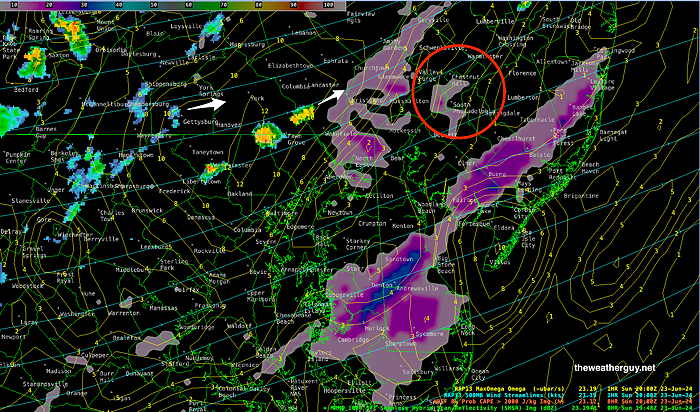
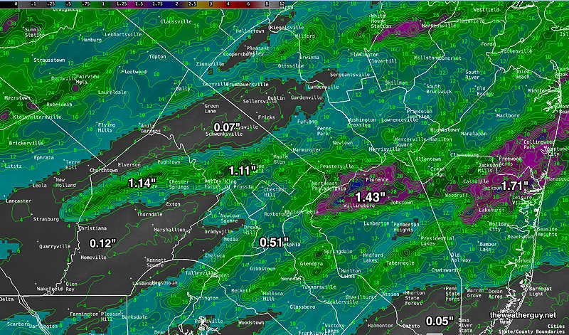
Particularly impressive was the HRDPS forecast which closely captured the band of heavy rain in NJ.

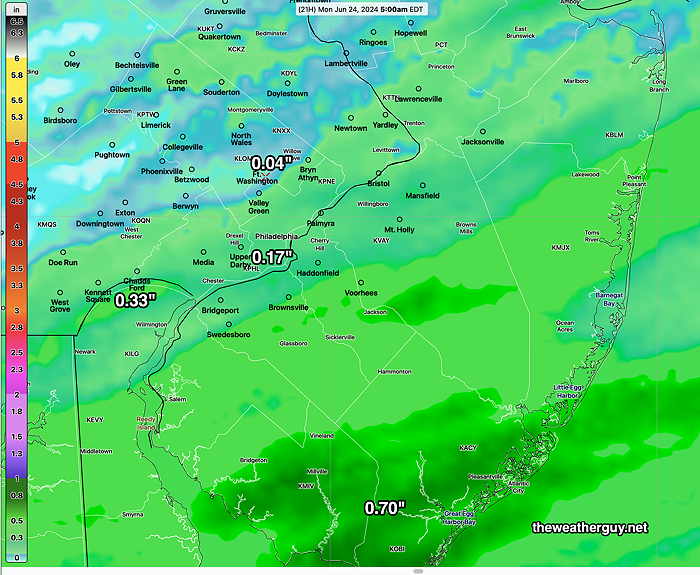
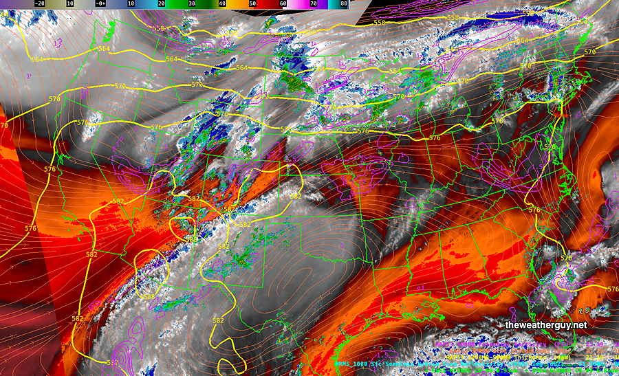
Here’s the MRMS rainfall summary for Sunday night—

MRMS rain-gauge measured rainfall combined with rain-guage calibrated and interpolated radar-based summary of ACTUAL RAINFALL received. Color shading is in inches. Line contour numbers are in mm. (25.4 mm= 1 inch)      (Click on image for a larger view.)

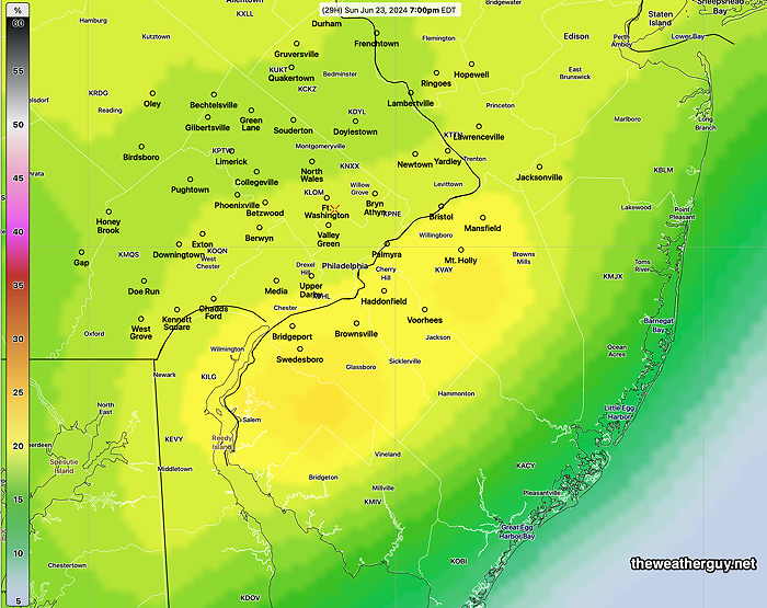
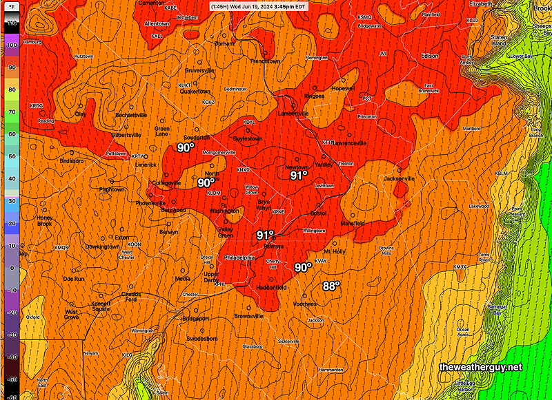
For today, Monday, the heat dome is suppressed to our south and we’ll be in a cooler cyclonic jet flow north of the heat dome.

NAEFS shows jet stream dip over the Northeastern US on Wednesday. Of interest is the cold pool of air still visible in Canada demarcated by the red 540 thickness line. It’s strange to still see this feature this late in June. Note the heat dome, demarcated by the orange 576 thickness line is suppressed to our south for now.

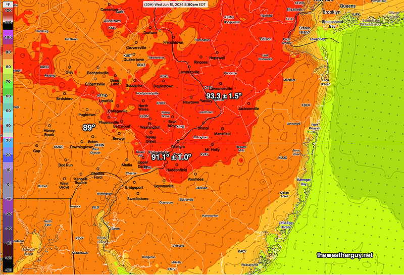
By Tuesday and Wednesday, the heat dome starts poking up northward and temperatures return to upper 80s Tuesday and near and above 90 Wednesday.

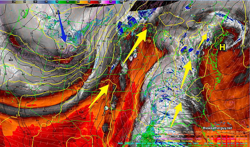
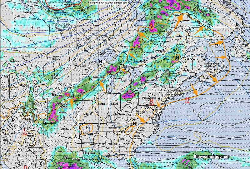
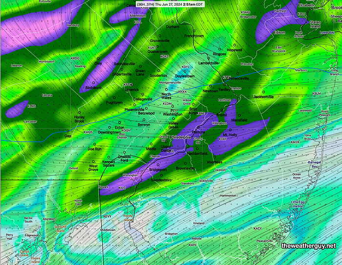
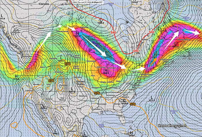
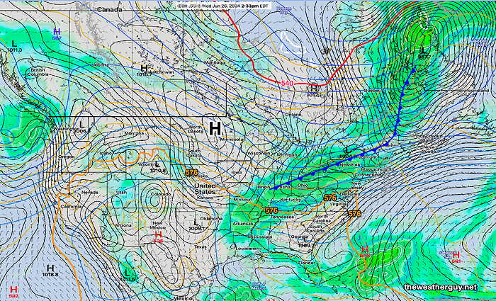
Here’s the surface map for late Wednesday showing a cold front moving through late in the afternoon. It looks like we’ll have some rain/thunderstorms late Wednesday into Wednesday night.

NAEFS late Wednesday forecast with approaching cold front. (Click on image for a larger view.)

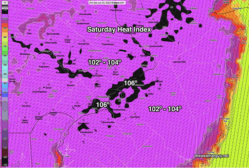
After a brief cool-down Thursday, temperatures look to rise again into the 90s by Saturday and Sunday. Another cold front moves through next Sunday night.


WEEKEND WEATHER FORECAST

#Philadelphia #weather #PAwx

Sunday Forecast Update

Posted Sunday 06/23/24 @ 4:18 PM —If you were expecting today’s rainfall to fully water your garden or lawn, you may be disappointed. Numerous models have the the showers diminishing in intensity in the immediate Philadelphia area. We could use the rain, but I’m not convinced we’ll see all that much. A few areas may get a good soaking but it seems that many won’t.

MRMS radar with superimposed HREF CAPE probability (purple shading) and vertical motion yellow contours (Max Omega) (Click on image for a larger view.)

Posted Sunday 06/23/24 @ 10:27 AM — The approaching cold front is in Ohio this morning with a line of showers and storms in western PA—

Water Vapor and MRMS radar summary with 500 mb windstreams at 10 AM I’ve drawn the approximate location of the cold front. In the oval is another disturbance ahead of the front that may triggers some storms this afternoon. Click on image for a larger view.)

This front will be a slow mover, not likely passing through here until 4-5 AM Monday.

Clouds well ahead of the front don’t appear to have changed the forecast high of 96-98º for the immediate Philadelphia area.

An increasing chance of thunderstorms after 1 PM with widely scattered storms possible west of the city as early 1-3 PM. Most likely period here in the immediate PHL area between 5 and 9 PM, but some scattered activity possible into the pre-dawn on Monday. It still appears that the heaviest activity will be in NJ this evening between 7 PM and midnight.

Total rainfall doesn’t look that impressive according to the NBM—

NBM total rainfall for Sunday through 5 AM Monday. (Click on image for a larger view.)

The Canadian HRDPS shows greater rainfall totals—

HRDPS total rainfall through 5 AM (Click on image for a larger view.)

Sunday Forecast Update

Posted Saturday 06/22/24 @ 7:52 PM — We had some thundershowers in the early to mid afternoon Saturday, not predicted by many models. (The Canadian HRDPS forecast some early storms, mostly west). These showers kept the high temperatures ‘only’ in the 96º-98ª range.

NexRad radar Saturday at 2:27 PM. Fast moving small storms. (Click on image for a larger view.)

For Sunday, a weak front is expected to move through late in the day, preceded by a line of showers and thunderstorms. Most likely time for the storms is about 4 PM far western areas, 5-6 PM in Philadelphia. As the storms enter NJ, they’re forecast to intensify.

Following our last round of poorly forecast storms a week ago, I mentioned I would be changing my approach. So I’m changing my methodology for forecasting thunderstorms.

It’s no secret that thunderstorms are best forecast with a probability-based approach. As such, I’m going to rely on the probability parameters of the HREF, NBM and the HRDPS, instead of my past approach of favoring one model’s timing and storm placement over another.

For Sunday, high temperatures look to be less than previously forecast. Highs will ‘only’ be in the 96º-98º range, similar to today. However, dew points will be near 70º, making it feel as hot if not hotter.

While there may be a main line of storms that move through 4-7 PM in Philadelphia, additional showers and storms, before and after the main line.

While the highest chance of storms in the immediate Philadelphia area will be between 4 PM and 7 PM, there are indications that some storms may move in from the northwest and blossom earlier in western suburbs, 1-3 PM —

HREF probability of CAPE >2000 joules/kg at 2 PM. Storms will likely develop or enhance in this region between 1-3 PM. Some storms will move in from the far northwest at this time. (Click on image for a larger view.)

Most models show any storms that move through Philadelphia may become more severe in NJ. By 6- 7 PM, the highest probability of storms has entered into NJ and are expected to intensify—

NBM Probability of thunderstorms. (Click on image for a larger view.)

While all thunderstorms may be locally severe, the overall severity parameters on Sunday are unimpressive, except closer to NYC.


Saturday Forecast Update

Posted Saturday 06/22/24 @ 10:16 AM — The model forecast guidance continues with a forecast of high temperatures in the 99º range in some areas today. Dew points are forecast to be near 70º, making the “apparent temperature” (heat index) over 100º around 3 PM—

This morning’s 12z NBM heat index forecast for Saturday at 3 PM. (Click on image for a larger view.)

As for showers/thunderstorms, while possible, the hourly probability in the immediate Philadelphia -Delaware Valley area is less than 13%. That’s not zero, so a widely scattered thunderstorm is possible later this afternoon, but when it comes to hourly probabilities, I usually look for 18% and higher. Those POPs great than 18% are far north of our area today.

The Canadian HRDPS has some storms as early as 2 PM around Doylestown and areas far west of the city. The experimental RRFS also has a few storms, mostly north. The HRRR has little in the way of storms around here, but a few in central and northern NJ.


Previously Posted Fri 5:33 PM —I’m pretty sure everyone reading this blog knows it’s going to be hot weekend. What value add can I provide to that forecast?

With high temperatures approaching 99º Saturday and possibly exceeding 100º on Sunday, there’s a slight chance of widely scattered thundershowers Saturday evening and a better chance of organized thunderstorms later Sunday evening or night with the approach of a cold front. Most areas will not see any showers Saturday.

A big factor this weekend will be the concomitant increase in humidity with the high temperatures. Some areas will have dew points in the mid 60s while others will have dew points near 70º

Current satellite water vapor image

Current satellite water vapor image with superimposed RAP model 500-1000 mb thickness lines (yellow), potential vorticity (fine violet contours) with superimposed MRMS RADAR. Notice the 576 thickness line just north of the Pennsylvania border. The disturbances along the front in the northern US are expected to drop through our area late Sunday into Monday. Right now the imagery doesn’t show this movement southward. (Click on image for a larger view.)

Low pressure is expected to form along the boundary to our north and its circulation will move a weak front through Sunday night. To mix it up a bit, here’s the latest ICON model forecast for 8 PM Sunday—

Today’s 12z German ICON model showing low pressure to our north. A weak front moves through late Sunday into Monday. Note the 576 thickness line (orange line) still to our north (Click on image for a larger view.)

Saturday

Sunny and very hot and humid. Slight chance of widely scattered thermally driven thundershowers late afternoon or evening.

High temperatures (latest NBM model)

NBM high temps Saturday (Click on image for a larger view.)

Sunday

Sunny in the morning, increasing clouds after 2 PM from west to east. Showers and thunderstorms early evening into night. Difficult at this time to access the the actual thunderstorm threat. I’ll update over the weekend.

NBM high temperatures—


THIS WEEK’S WEATHER

#Philadelphia #weather #PAwx

Friday through Sunday Update

Posted Thursday 06/20/24 @ 9:28 AM — Last night’s models show a trend towards higher temperatures Friday through Sunday, with the ECMWF and NBM showing areas exceeding 100º on Sunday. (That’s actual temperatures, not heat indices.) Heat indices (“apparent temperatures”) may exceed 105º)

High Temperatures Sunday

Latest 12z NBM high temperatures for Sunday. (Click on image for a larger view.)

Apparent Temperatures (Heat indices) on Sunday

So the current trend is for higher temperatures over the weekend than previously forecast earlier this week.


Thursday Friday Forecast Update

Posted Wednesday 06/19/24 @ 7:18 PM — The model guidance has backed off on the chance of showers in this area for Friday evening. Showers and thunderstorms will likely stay to our far north.

Today’s highs, based on the RTMA at 3:45 PM, showed temperatures in the city were close to those forecast yesterday by the NBM, although higher temperatures that had been forecast near Trenton did not materialize. Here’s today’s RTMA readings at 3:45 PM —

RTMA temperatures at 3:45 PM Wednesday. Contours are 1º increments (Click on image for a larger view.)

For Thursday, temperatures a degree or so warmer than today. Dew points will be higher, though, making it feel hotter.

The models have also come down a degree or so for Friday‘s high temperatures. Still forecast in the low to mid 90s.

Some pop-up thunderstorms possible Saturday. Some may be strong.

Temperatures above 90º now forecast through Monday. Perhaps a drop below 90º for Tuesday, then a return to the 90s!


Forecast Update

Posted Tuesday 06/18/24 @ 7:52 PM — This afternoon’s models are showing a mid level disturbance moving through over the top of the heat dome. Scattered showers and thunderstorms are possible Friday evening, especially areas north of Philadelphia.

Increasingly Hot

Posted Tuesday 06/18/24 @ 5:36 PM — Other than the increasing heat over the next several days, there isn’t much ‘weather’. No showers or thunderstorms are expected in this area into Friday, however, there’s a chance of scattered storms Friday evening/night, especially northwestern areas.

Tuesday afternoon Water Vapor Image shows two ‘tongues’ of hot air conveyor belts. Each group of yellow arrows are within the 576 thickness line outlining the heat domes. (Click on image for a larger view.)

The temperatures we’re seeing are hot. What’s most concerning is that it isn’t yet officially summer.

A picture, or in this case several pictures, capture the increasing temperatures Wednesday through Friday —

NBM high temperatures Wednesday Contours are 1º increments (Click on image for a larger view.)
NBM high temperatures Thursday Contours are 1º increments (Click on image for a larger view.)
NBM high temperatures Friday Contours are 1º increments (Click on image for a larger view.)

Saturday may be as hot as Friday and Sunday looks quite hot too.


Posted Monday 06/17/24 @ 8:34 AM — Most models are keeping the high temperatures in most areas in the Delaware Valley just below 90º on Monday, but dew points are expected to reach the mid 60s in the afternoon. As a result, heat indices will be about 91º in many areas.

Here’s the latest NBM high temperature forecast for today, Monday

Today’s 06z NBM high temperature forecast for Monday.. (Click on image for a larger view.)

Lower 90s are expected Tuesday and Wednesday. The heat gets more serious on Thursday with temperatures in many areas above 95º

By Friday, the heat is expected to be intense—

06z NBM high temperature forecast for this Friday. (Click on image for a larger view.)

Previously Posted Sun 7:56 PM —I guess you’ve probably heard that it’s going to be hot this week. This northward advance of hot air has been well-advertised by the extended range models as early as 2 weeks ago. The ‘heat dome’ will be over much of the central and northeastern US (even well into Canada) through at least next Saturday or Sunday.

The heat dome can be ‘visualized’ through a calculated weather parameter called thickness, specifically the 500mb-1000mb thickness. This thickness parameter reflects the average temperature (density) of of the lower half of the atmosphere. Greater values of this parameter show greater average temperature.

In winter, the 540 thickness level often demarcates the rain-snow line.

In summer, the 576 thickness is useful to visualize the outline of the heat dome. I like to think of it the outline of a horizontal slice through the atmosphere that only includes its (hottest) thickest area. There’s nothing magical about 576, but I find it to be the number that seems to best define the outline of the heat dome. Strangely, there’s often showers/thunderstorms on the northern side of the 576 thickness line.

Here’s the ECMWF forecast for Wednesday. The orange line is the 576 thickness line, outlining what the news is calling a heat dome—

Today’s ECMWF forecast forWedensday. The area within the orange contour is the 576 ( 500mb-1000mb) thickness. Areas within that line have the hottest weather. I’ve drawn orange arrows to better visualize the line location. Interestingly, the 540 thickness line (red) is still visible in part of Canada. (Click on image for a larger view.)

Here’s the this morning’s NBM forecast highs through Wednesday. Temperatures on Thursday through Saturday are expected to be even higher.

MONDAYTUESDAYWEDNESDAY
BLUE BELL89.092.392.8
PHILADELPHIA89.793.193.6
Today’s 12z NBM model mean high temp forecast usually reached between 3PM and 4PM. All temps have average confidence with an sd of ± 1.5º

The NBM is a mean (average) temperature calculated from 40 + models. In past summers, high temperatures were best calculated by adding the standard deviation (sd) to the mean, in this case adding about 1.5º.


Weather… and Other Things 'Up in the Air'