THIS WEEK’S WEATHER

#Philadelphia #weather #PAwx #drought

Philly Drought Watch

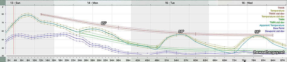
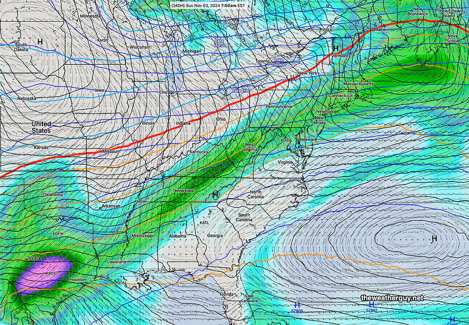
Posted Friday 10/25/24 @ 11:28 AM — Our next chance of any rain appears to be the first few days of November. Unfortunately, the latest AI and ensemble models show an upper air ridge in our area that may seriously reduce the amount of rainfall we get ahead of a cold front.

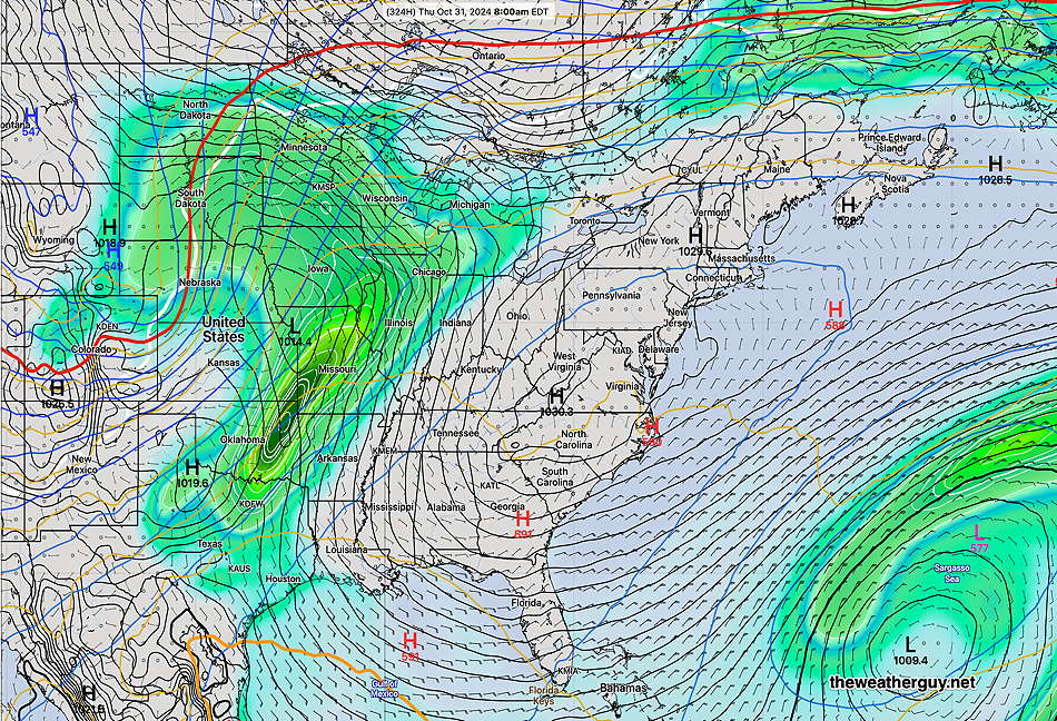
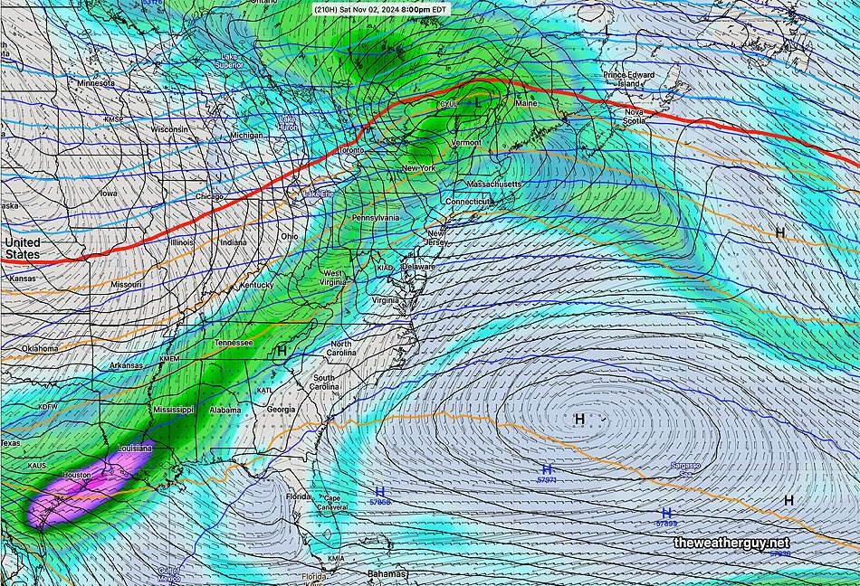
Here’s the ECMWF-AIFS forecast for November 2

ECMWF-AIFS (Artificial Intelligence Model) forecast for 8 PM Saturday Nov 2nd. Light showers ahead of a cold front, dissipating as they move eastward. (Click on image for a larger view.)

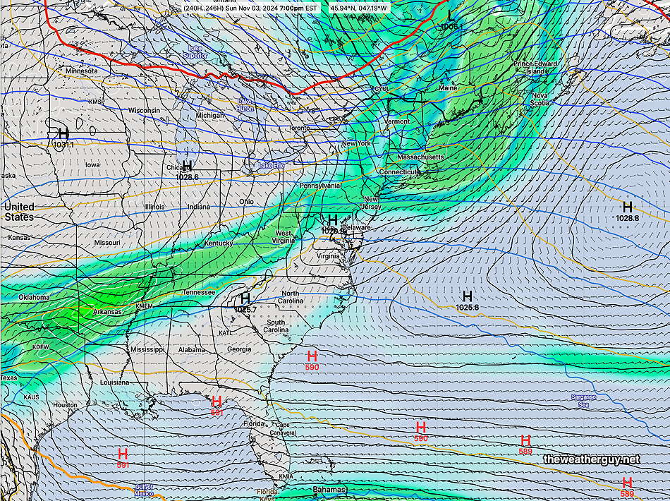
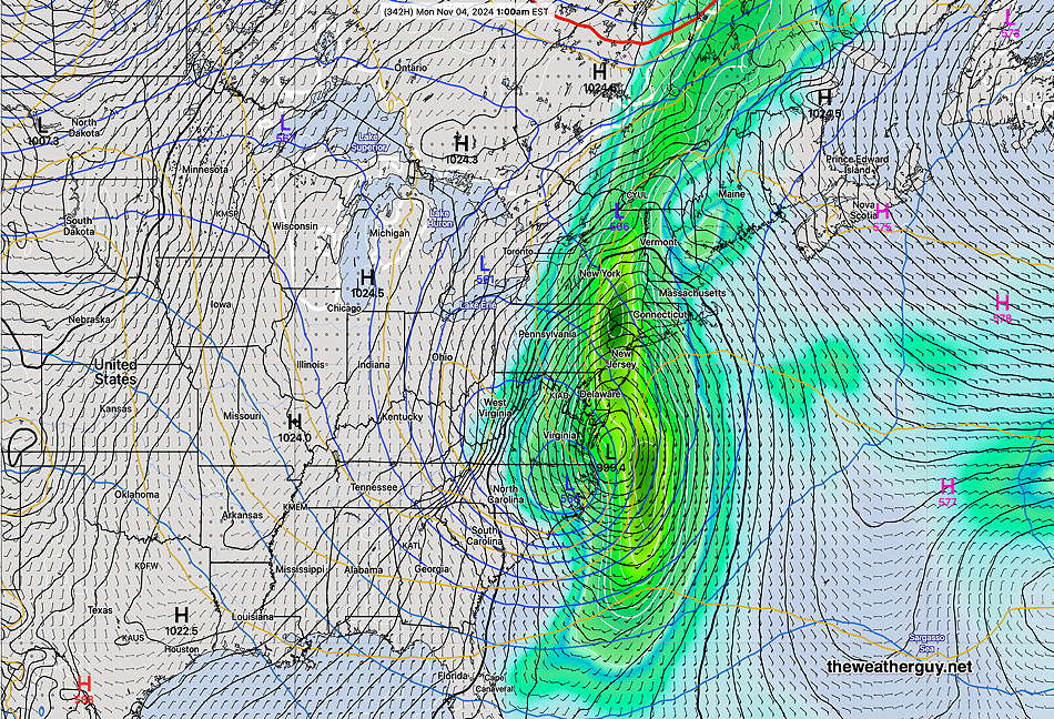
Here’s the GFS AI model forecast for Sunday Nov 3rd—

GFS Graphcast AI Machine Learning Model forecast for Sunday Nov 3 at 7 PM. Again, upper ridge will reduce our rainfall potential. (Click on image for a larger view.)

On the more positive side is the NAEFS (ensemble model combined GEFS and Canadian ensemble). It’s forecasting more rain and possible coastal tropical system near Florida. Likely not correct—

NAEFS forecast for Wednesday Nov 6th . Tropical system hinted at near Florida coasts. (Click on image for a larger view.)

The Drought Continues

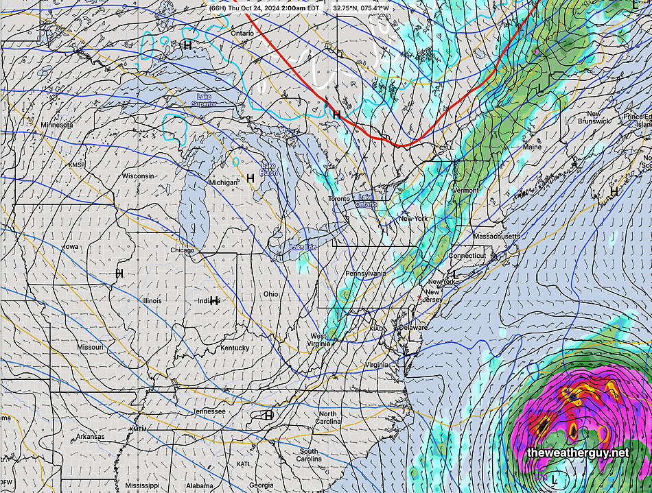
Posted Thursday 10/24/24 @ 5:01 PM — I can’t remember the last time I saw so many large sprawling high-pressure systems on the weather map. Our dry weather is expected to continue into the first few days of November.

Until that time, we’ll have some colder periods towards the end of this weekend as a second cold front moves through early Saturday. We’ll see another warm-up next week. And mostly sunny skies shall prevail.

I may have to rename this blog, “The Rain Watch”. I’m currently using various statistical ensemble models and the ECMWF-AI and GFS-AI models to see about our next chance of rain

We may finally get some rain, albeit, hardly a drought-buster, sometime in the November 3rd through November 5th time frame.

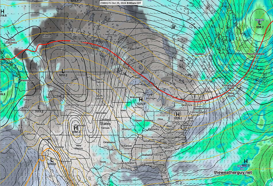
Here’s the ECMWF-AIFS forecast for November 3—

ECMWF-AIFS forecast for 7 AM November 3. A cold front moves through with about a quarter inch of rain, possibly more if low pressure develops along the front. (Click on image for a larger view.)

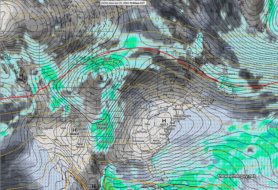
Posted Tuesday 10/22/24 @ 4:27 PM — As mentioned yesterday, two cold fronts will move through in the coming days; one late Wednesday night into Thursday and another late Friday night into Saturday.

These frontal passages have been forecast to be dry, but today’s ECMWF and Canadian RGEM show a deeper trough moving through with enough lift for with some sprinkles, mainly in NJ late Wednesday night. The few sprinkles forecast are supported by the experimental REFS. (The ECMWF-AIFS shows no showers.)

We’re only talking a one or two hundredths of an inch in a few locations.

During the weekend, our current well above average temperatures will drop to noticeably cooler levels.

The GraphCast AI-Machine Learning version of the GFS has moved the chance of rain here further down the road into November from yesterday’s forecast. So the drought continues.

10-22-24 00z Graphcast-GFS forecast for Monday, November 4th. Our first chance of light rain?? (Click on image for a larger view.)

No Rain

It’s been a long time since things seemed so dry outside. And the current extended range forecasts keep thing dry for us over the next two weeks!

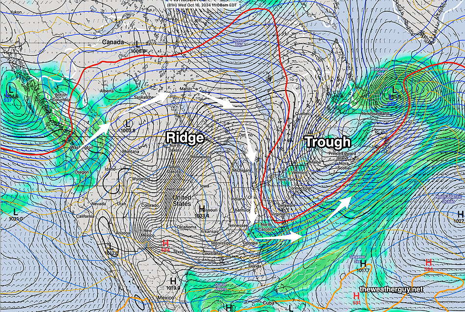
Yes, there will be two cold fronts moving through this week. The first one will result in a familiar pattern of having any rain shear off to the far north and west of the city—

Today’s ECMWF shows showers only far north of the city. (Click on image for a larger view.)

Another cold front moves through Saturday. The models had been forecasting some light showers for us, but those have all but disappeared in the forecast—

Today’s GFS forecast for Saturday. Grey black is cloud cover. Essentially no rain with this front. (Click on image for a larger view.)

I’m still playing with the highly experimental AI-Machine Learning version of the GFS. It still seems to show the first chance of any substantial rain here is November 3rd!

Graphcast GFS (AI Machine Learning model ) forecast for November 3rd. (Click on image for a larger view.)

All I can say is “Wow”.


WEEKEND WEATHER FORECAST

#Philadelphia #weather #PAwx

There’s almost no reason for a weather forecast for this weekend and certainly not a reason for many updates. You’ve heard the details on the radio or TV.

Sprawling dominant high pressure and a persistent upper air ridge will give us sunny skies and increasingly warm temperatures. I don’t see any rain here in the Philadelphia area until the end of October, possibly on Halloween, according to the NAEFS and into November according to the GFS AI model.

During this downtime, I’ve been exploring programming downloads and post processing of some the the experimental AI models.

Regular readers here have seen that the ECMWF-AIFS was quite impressive with its forecast of Helene and Milton.

NOAA also has what they call an experimental “machine learning model” which is a combined effort with Google (Graphcast) and uses the weather database of the ECMWF. It compares current conditions to a weather database going back to the late 70s with several parameters at 13 vertical atmospheric levels to create a forecast.

Over the past week or so, I’ve been working on programming the download and post processing of what’s called the Experimental Graphcast-GFS model. (Weather model downloads are much more complex than simply “click here” for the model.)

Here’s its forecast for October 31st at 8 AM, showing the first area of rain on the map for awhile. Notice that the rain is blocked to our west by high pressure.

10-18-24 00z Experimental Graphcast GFS for Halloween morning. High pressure still blocking rainfall. But it suggests a pattern change within several days of this date. (Click on image for a larger view.)

THIS WEEK’S WEATHER

#Philadelphia #weather #PAwx

NO RAIN for Philadelphia Area

Posted Thursday 10/17/24 @ 11:26 AM — The latest extended range models are in good agreement and currently show little to no rain (and certainly no meaningful rainfall ) through Oct 29th.

10-17-24 06z GEFS cloud (dark grey) and precip for next Friday, High Pressure dominates the US (Click on image for a larger view.)

The ECMWF-AIFS, which was impressive with its predictions of Helene and Milton, shows no tropical development to affect the mainland US within the next week or so.


Yet Another Pattern Change But NO Rain

Posted Tuesday 10/15/24 @ 5:09 PM — The cold upper air trough will dissipate by the end of the week. Troughs often spawn low pressure, and the current trough will spawn a low that will form off the coast, not giving us any rain.

The upper ridge in the central US will move over us by the weekend and the upper ridge will be with us through most if not all of next week. NO rain expected through at least the end of next week.

Here’s what we’re evolving into by next Monday. A broad ridge across the continental US and dry high pressure over us—

10-15-24 12z GEFS forecast for next Monday. This is stagnant through all of next week. Not a drop of rain!

A Pattern Change

Originally Posted Sun @ 4:21 PM — —The models are showing signs of an evolving pattern change beginning this week. Most obvious will be a developing trough in the the northeastern US giving us much cooler temperatures following a cold front passage tonight.

NAEFS for Wednesday. Cold upper air trough over the northeastern US. (Click on image for a larger view.)

Here’s the NBM temperatures through Wednesday—

10-13-24 12z NBM temperatures and dew points through Wednesday. Signficant drop in high and low temperatures (Click on image for a larger view.)

A cold front moves through tonight. Showers associated with this front will likely stay to our north. A few models vacillate on whether the Philadelphia area will see any showers or sprinkles with an upper air disturbance that moves through Monday morning. If we get anything, it will be scattered and very light.

The upper trough for the first part of this week may cause some instability cloudiness, perhaps more than the models are showing.

With the upper blocking ridge in the central US breaking down by the end of this week, we may finally see some systems by next week bring us some rain. although I don’t see any specific system yet in the extended range models.


Weather… and Other Things 'Up in the Air'