Sun 08:35 PM Forecast Review — The thunderstorms came through close to schedule about 6:45 PM . This afternoon’s models only showed CAPE values of 580 joules/kg, not the 1300 predicted by yesterday’s HRRR. So storms were typical, not severe.
from yesterday …
The forecast is on track with rain on Sunday, starting between 6 AM and 8 AM.
Most models have the rain becoming more episodic in the afternoon, with lines of showers moving through with breaks in the rain . Heaviest rain is now expected west of the Philadelphia area. QPF about 0.6 inches for Blue Bell. It will become WINDY. High near 68º
A final line of showers and thunderstorms appears to be timed between 5-7 PM in the immediate PHL area with the cold front passage. Available thermodynamic energy (“CAPE”) values may exceed 1300 joules/kg which could cause some strong storms from Philadephia and eastward.
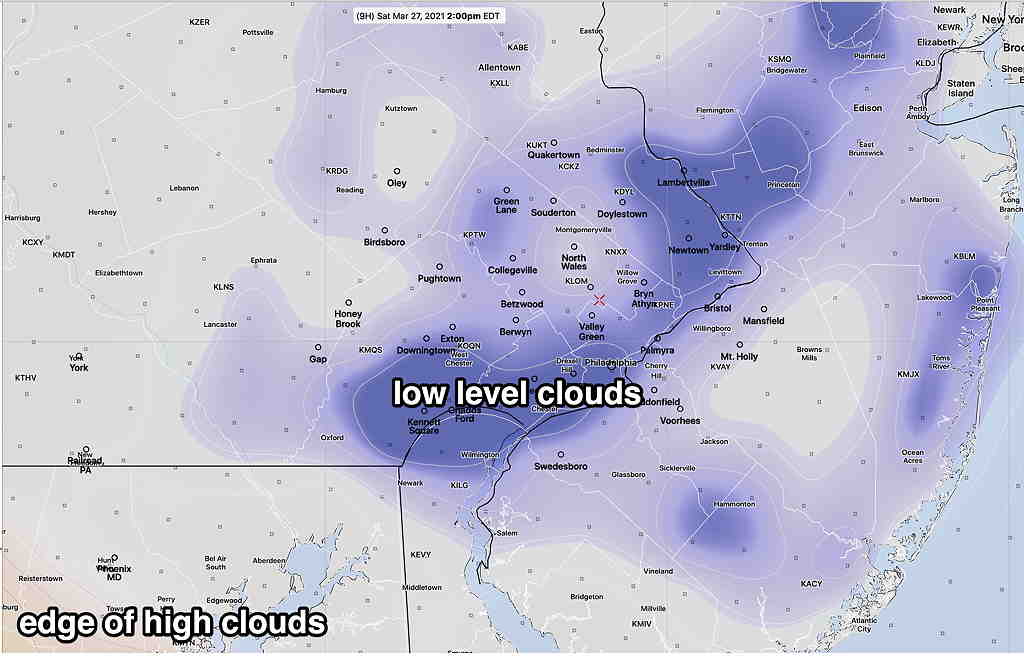
Sat 05:41 PM Forecast Review — We never got the low level cloudiness as shown in the graphic below, but the increasingly thick layer of high clouds (cirrus followed by high level altostratus) came in on schedule.
Several of the latest models with their new “cloud physics” modules seem to over-state low level cloudiness. I’ve seen that often with the HRRRv4 and RAPv5 model versions that were released in the fall of 2020.
Forecast Update Sat 8:20AM — Just some timing updates. There had been some uncertainties with Sunday’s forecast. Last night’s models suggest that the rain on Sunday will last later into the afternoon (3-4 PM) with a second line of showers/thunderstorms associated with the cold front between 6 and 7 PM.
Additionally, several models show an area of low clouds about 1-4PM today (Saturday) associated with an upper air feature. Sometimes the new HRRR and RAP models over-state cloudiness. We’ll see.
RAP cloud forecast Saturday 2 PM (Click on image for a larger view.)
From Friday evening…
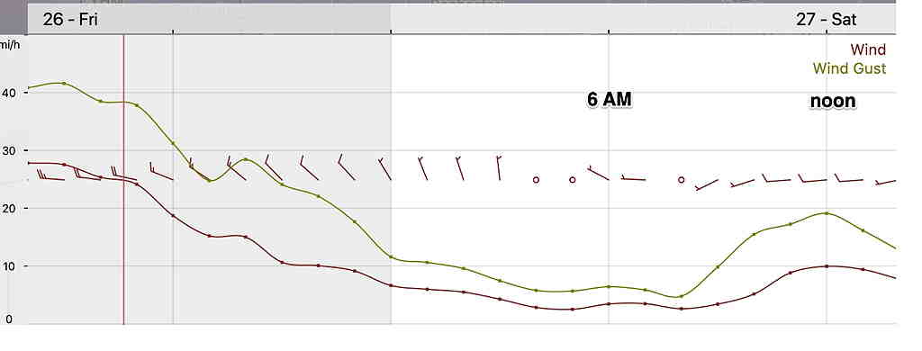
Today’s weather was indeed interesting, with wind gusts exceeding 50 mph and temperatures exceeding 80º!
The weekend will start more tranquil. High pressure builds in for Saturday. Saturday will be mostly sunny, although high clouds move in during the afternoon. High temperatures 68º ± 2.5º (NBM Model, Blue Bell). Winds will be more manageable than today—
HRRR Wind Meteogram (Click on image for a larger view.)
Yet another low pressure system moves to our west on Sunday, bringing rain for Sunday morning ahead of another warm front. Rain will begin early morning, about 6-8 AM. Total QPF expected 0.6 inches.
The warm front moves north of us and rain will end Sunday afternoon. It will become WINDY (but nothing like Friday).
There’s uncertainty whether the rain ends as early as 1-2 PM or as late as 4 PM. Some models have some break in the clouds Sunday afternoon, maybe some sun after the warm front passage. High temp 68º± 3.3º
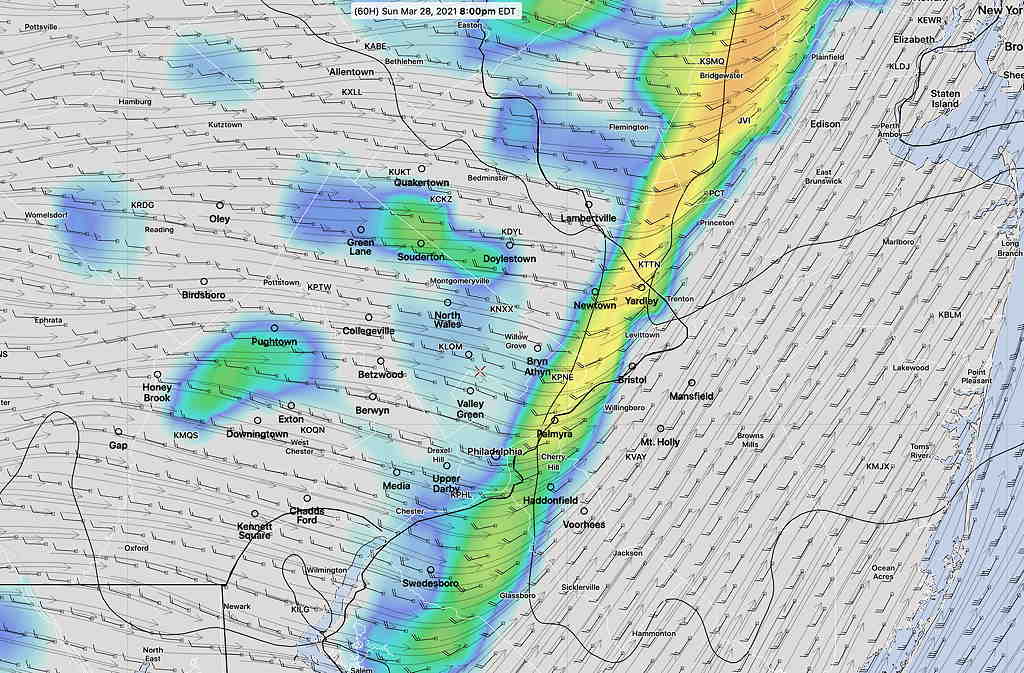
A strong cold front associated with the same system moves through late Sunday afternoon or Sunday evening. Several models are forecasting a line of showers and thunderstorms Sunday late afternoon or evening with the cold front passage.
HIRESW-FV3 (pre-release version) Simulated Radar forecast 8 PM Sunday (Click on image for a larger view.)
Monday will be much cooler than the prior few days.
Fri 09:39 AM Forecast Review — Some fast moving showers occurred before daybreak but no thunderstorms in the immediate PHL area. Current models have revised the wind gusts down to the 45 mph range around noon. The NBM now shows temperatures 78- 80º today!
Thu 08:17 PM Update — Today’s models have increased the likelihood of showers and [possibly] thunderstorms ahead of the warm front that will pass through between 3AM and 6AM Friday morning. Indeed, a few showers will move in this evening, especially north and west. Severe weather parameters are not all that impressive in our area, but we may have our first thunderstorms of this season before or around daybreak. The actual cold front moves through about noon. It’s not expected that thunderstorms will accompany the actual cold front.
However, winds will increase during the morning and gusts of 50 mph are possible with the cold front passage around noon. It will be very mild. Temps well into the 70s!
From Wednesday…
Wednesday’s heavy rain was predicted by the models less than 18 hours in advance; prior model forecasts only had about a half inch of rain ( or less) for today. Interestingly, the German ICON was the first to jump on the heavy rain bandwagon.
I’m not sure the models are capturing the full potential for “interesting”weather on Friday. A warm front moves through just before daybreak Friday. Accompanying this front is the potential for thunderstorms in the predawn hours, although the models are currently keeping the strong dynamics to our west. Predawn warm fronts can often surprise.
Friday will be VERY WARM and VERY WINDY. Highs will be into the 70s! Wind gusts may approach 50mph. A weak cold front moves through as early as late morning. The highest winds will accompany the frontal passage. The models currently are downplaying additional thunderstorms. Too early to tell.
If you liked today’s weather, you’ll probably like Sunday’s weather, which is looking quite rainy.