THIS WEEK’S WEATHER

#Philadelphia #weather #PAwx

Friday Forecast Update

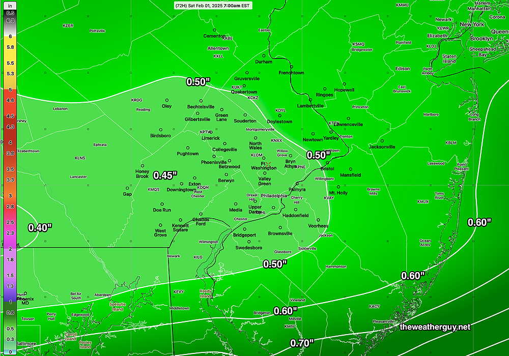
Posted Friday 01/31/25 @ 9:32 AM — A slight shift in the timing of the heavier rain today— late afternoon through this evening, ending after midnight. Total rainfall in the city and surrounding areas is now forecast to be less, closer to 0.30″-0.40″. Heavier rainfall in South Jersey.

NBM 12z Accumulated Rainfall for Friday into early Saturday. (Click on image for a larger view.)

The potential mixed precipitation storm I prematurely mentioned last evening has changed timing, from possibly next Saturday to possibly next Thursday. That’s a big change, suggesting the models, including the AI models, don’t yet have a good handle on things. Nonetheless, the setup ingredients appear to be there. Stay tuned.


Friday’s Rain Update

Posted Thursday 01/30/25 @ 6:01 PM — The rainy forecast for Friday hasn’t changed appreciably and rainfall totals are similar to the ECMWF forecast graphic posted yesterday. Rain begins about 3 AM Friday, earlier south and west and continues through about 9 PM Friday evening. It will be windy and gusty at times during the day, especially late afternoon when the heaviest rain is expected to fall.

The weekend looks as follows: Sunny on Saturday and cloudy on Sunday as a disturbance passes to our north.

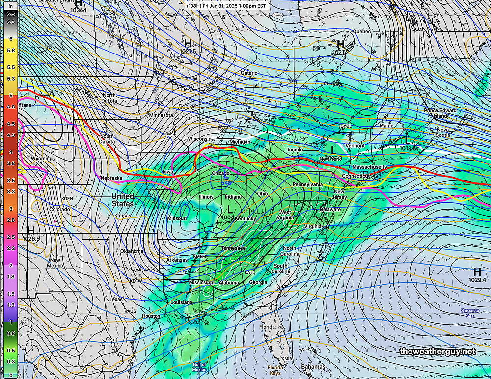
No major storms until NEXT weekend, when things may get interesting, according to the AI models and the ECMWF—

The ECMWF forecast for Superbowl Weekend (NEXT Saturday) Very far off in the future, but the setup is for a mixed bag of very heavy precipitation here. (Click on image for a larger view.)


Friday’s Rain

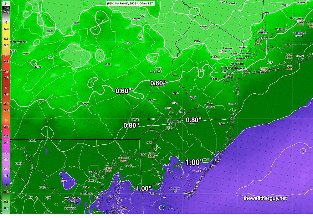
Posted Wednesday 01/29/25 @ 7:42 PM — A storm bringing only rain to our area will move in several hours before daybreak on Friday. It will be rainy all day and the rain will taper off during the evening.

Continuing our ongoing trend towards lower than average rainfall, we’ll only see 0.50″ of rain in the immediate Philadelphia area according to the AI model. Areas not far to our south will receive over an inch, according to the latest models.

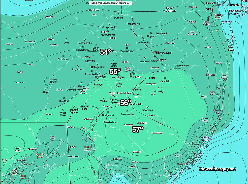
Staying with the AI model, here’s its forecast total rainfall for Friday—

Today’s 12z ECMWF-AIFS total accumulated rainfall by Saturday morning. (Click on image for a larger view.)

The NBM is forecasting heavier rainfall for Friday—

Today’s 18z NBM rainfall forecast (Click on image for a larger view.)

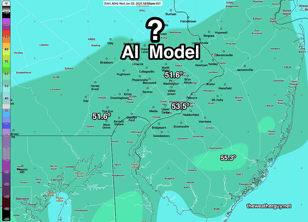
AI Model Looks Quite Good in Simple Experiment

Posted Wednesday 01/29/25 @ 5:47 PM — The temperature reached at Philadelphia airport today was 52º, 53º based on hourly records. ( If 53º was reached, it occurred off-hour and will be posted on the NWS site in a few hours.)

It’s very impressive that the AI model correctly forecast this range a week ago. Today’s NBM forecast was a still a degree so too cool.

Posted Wednesday 01/29/25 @ 9:39 AM —Over the past week, I’ve been conducting a simple observational experiment regarding today’s high temperature forecast. (Also see here.)

I chose to follow the AI model temperature forecast for today, because it was below freezing here at the time and the majority of the models, including my go-to model for temperatures (the NBM) were forecasting highs in the mid 40s for today, while the ECMWF-AIFS at that time was forecasting mid 50s! Quite a difference.

Incredibly, the regular model forecast have creeped upward towards the 50s and closer to the AI model while the ECMWF has shave off a few degrees to a high of near 53º.

Here’s the latest NBM —

Today’s NBM (12z) high temperature forecast for today. (Click on image for a larger view.)

Here’s the latest AI (ECMWF-AIFS) forecast for today—

Today’s ECMWF-AIFS high temperature forecast for today. (It should be noted that the ECMWF forecasts in 6 hour increments and the version I download does not include the day’s maximum temp. The only data is the actual temp at 1 PM as shown above. Since high temperatures typically occur around 3 PM, the actual max temp for today may be somewhat higher

What’s impressive is that the ECMWF-AIFS was forecasting this range of max temperatures almost a week ago! It took the computational models almost a week to approach its forecast.


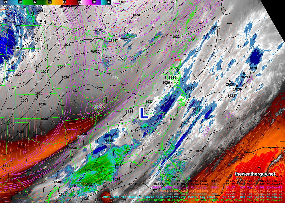
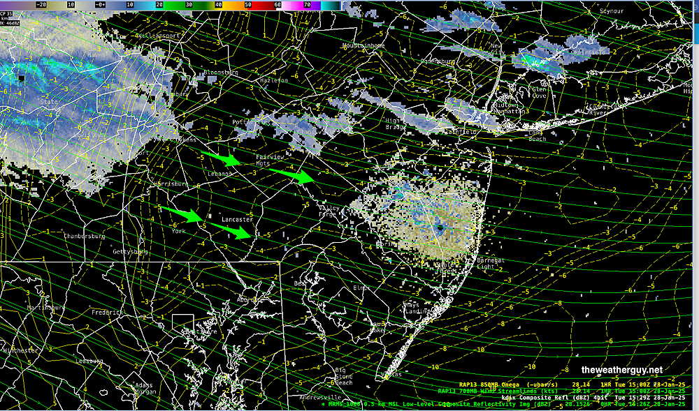
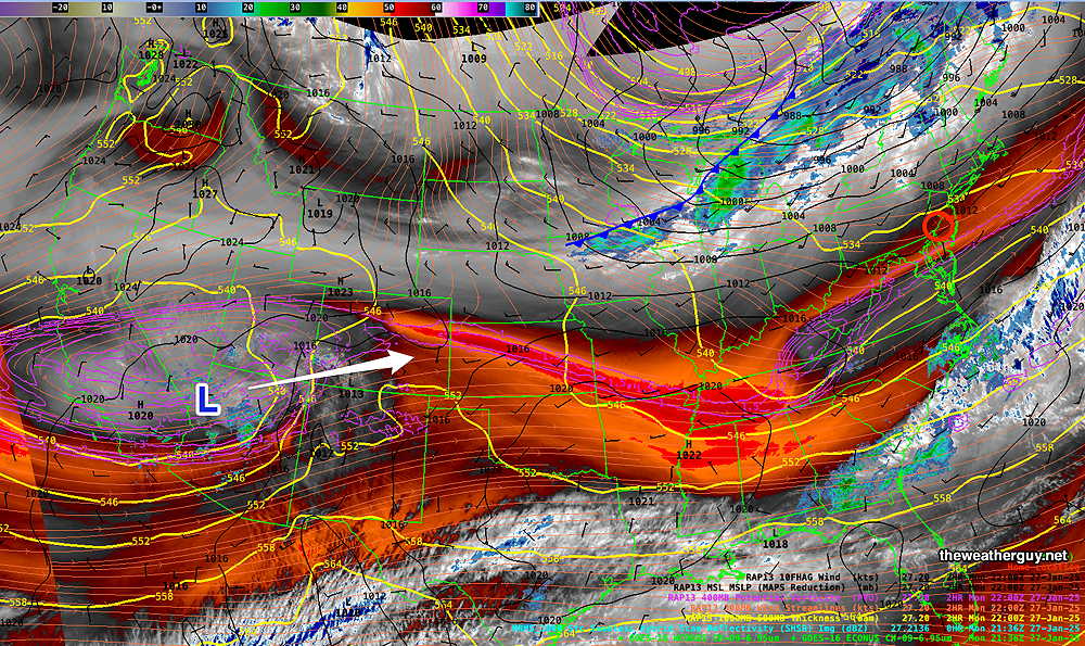
Posted Tuesday 01/28/25 @ 10:53 AM — Radar shows some snow showers to our far northwest. Superimposed RAP model vertical motion (“omega”) shows strong downward motion, likely dissipating these snow showers greatly by the time they get to Philadelphia—

Radar shows some snow showers to our northwest. Superimposed RAP model vertical motion (“omega”- yellow dashed lines are negative) shows strong downward motion, likely dissipating these snow showers greatly by the time they get to Philadelphia (Click on image for a larger view.)

Posted Tuesday 01/28/25 @ 9:17 AM — When I went to bed last night, the forecast for Philadelphia on our news radio station called for “‘”snow showers, possibly reducing visibility” and clouds. Did I miss something with my update yesterday? What were they talking about?

We’ll have a mix of sun and clouds today. Several weak disturbances are in the pipeline for us over the next few days. Snow/rain showers are a slight possibility.

WV image with superimposed RAP model parameters. Disturbances 1-3 are in the pipeline to affect us. The upper level low (4) will bring rain on Friday. (Click on image for a larger view.)

There’s a chance that the storm on Friday may start as a bit of freezing rain or sleet here before a change to all rain. Not a certainty.


Posted Monday 01/27/25 @ 5:55 PM — A slight warmup for Tuesday and Wednesday. The ECMWF-AI model has us in the low 50s on Wednesday. The model blend (NBM), my go-to model for temperatures, now has a forecast high of 48º in Philadelphia with a rather large standard deviation of ± 2.8º.

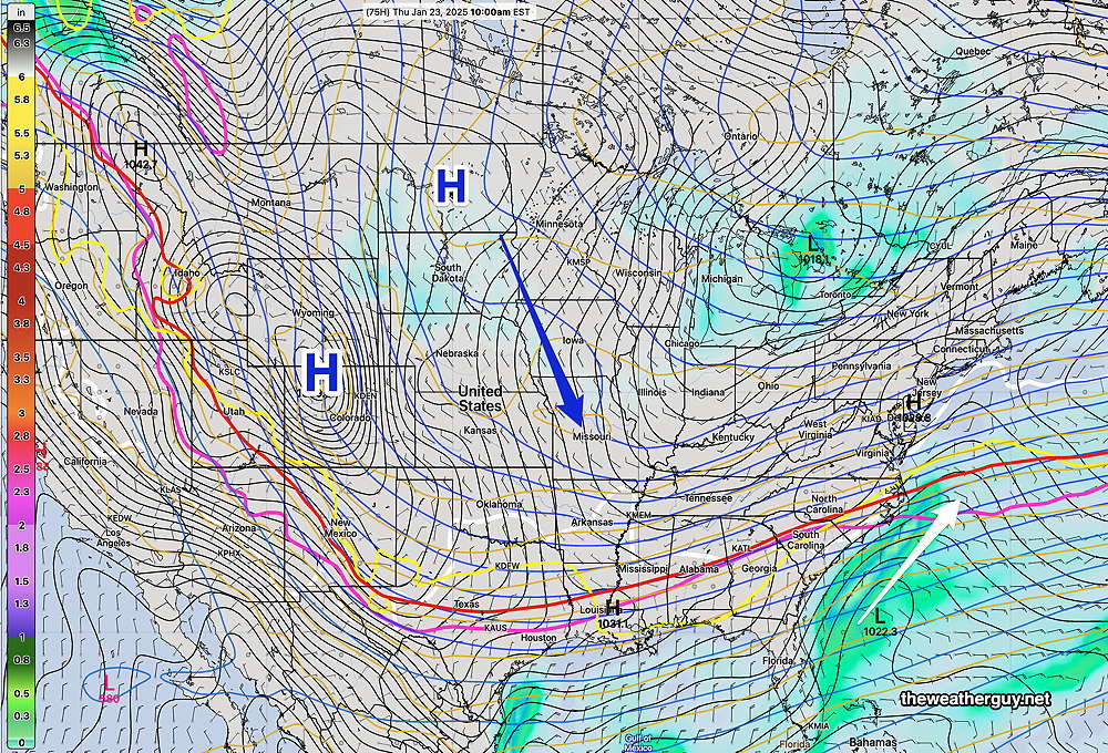
A series of weak fronts and upper air disturbances come through over the next few days, specifically before daybreak Tuesday and Tuesday night. A rain maker is on the way for Friday, although the heaviest rain may move to our north and south.

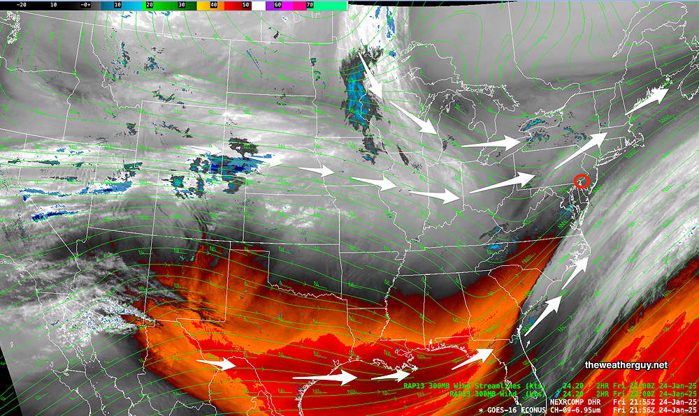
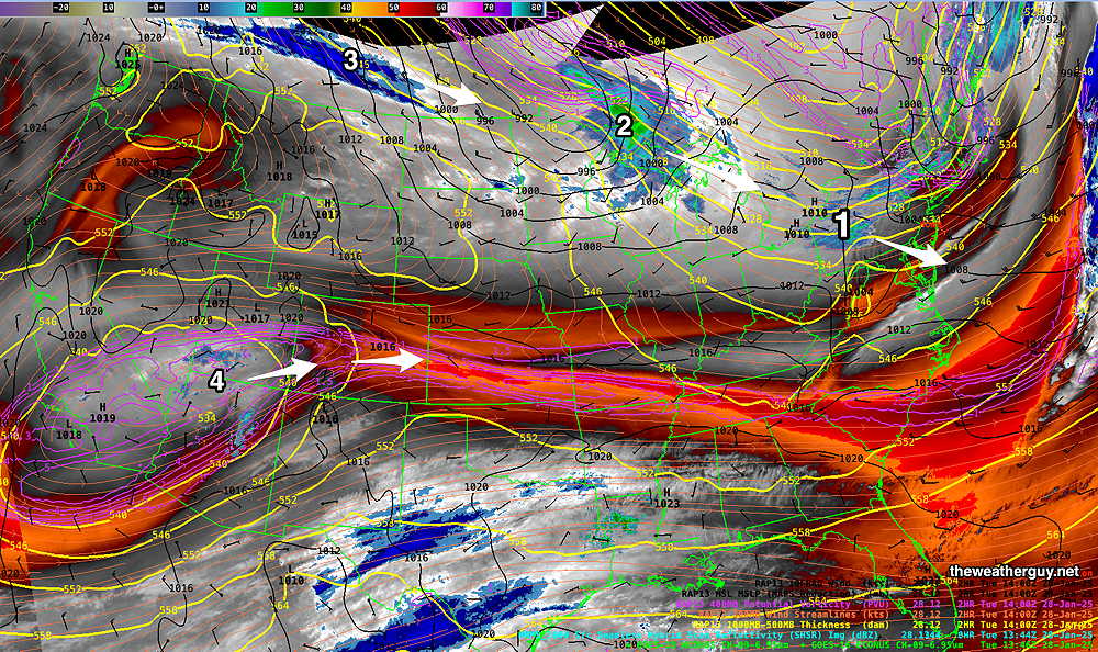
The front and the system bringing rain on Friday are visible on water vapor imagery—

Current satellite water vapor image with superimposed RAP model 500-1000 mb thickness lines (yellow), Mean Sea Level Pressure isobars (black contours) potential vorticity (fine violet contours) with superimposed MRMS RADAR. The closed low in the southwestern US will move into our area on Friday. (Click on image for a larger view.)

A note for those of you who are visiting this site from “X“.
Due to the highly unbalanced political environment on X, I’ve considerably cut back auto-posting there. To receive all forecast postings, I recommend following me on mastodon.social or bluesky.social

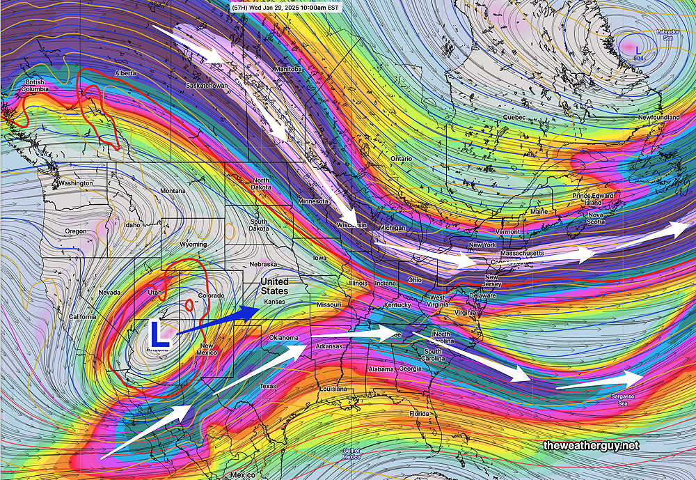
Originally Posted Mon 10:45 AM —A split jet flow and a still somewhat chilly northwesterly flow will keep temperatures slightly above average through Wednesday, becoming somewhat colder Thursday, then warming again Friday with rain.

Today’s 06z NAEFS jet stream wind speed forecast for Wednesday morning. The upper closed Low (L) will eject towards us bringing rain by Friday. (Click on image for a larger view.)

Regular readers here know that over the past week, I’ve been watching the AI version of the ECMWF which has consistently forecast high temperatures on Wednesday to be in the low 50s! Every other model has us in the mid to upper 40s. So this is a little experiment to see if the AI model has any special insights into high temperatures—

Today’s 06z ECMWF-AIFS forecast temperatures on Wednesday. Much higher, and consistently so. then the regular models. (Click on image for a larger view.)

It appears we may have some rain on Friday into early Saturday. This feature has been in the forecast for several past days, with each model run moving it earlier. (It was originally forecast for this rain to move in Saturday into Sunday.)

Today’s 06z NAEFS forecast for Friday at 1 PM. The white contour is 32º, the red, yellow and magenta lines are critical thickness lines, indicating the average temperature of different lower levels of the atmosphere. With all of these lines to our north, we will have rain, not snow. (Click on image for a larger view.)

The weekend looks to be dry.

No significant snow storms are on the horizon for us. For that matter, we’re still running a rain/snow deficit and the dry conditions of last Fall have not shown signs of ameliorating to this point.


WEEKEND WEATHER FORECAST

#Philadelphia #weather #PAwx

An upper level trough with cold high pressure that has been with us seemingly forever, will lift off to our northeast on Saturday. A disturbance passing to our north will bring just cloudiness Saturday night and during the morning on Sunday. Clearing Sunday afternoon.

WV image 5 PM today shows several disturbances that will pass to our north. The subtropical jet stream remains to our south, but a slight ridge tries to build in late Sunday into Monday. (Click on image for a larger view.)

The latest GFS shows the disturbances that will move to our north—

Today’s 18z GFS has the clipper-type disturbance moving to our north late Saturday. (Click on image for a larger view.)

By Sunday afternoon , the weak disturbance has moved to our northeast along with a weak trough. High pressure builds in from the west—

GFS forecast for Sunday 4 PM. (Click on image for a larger view.)

Saturday Forecast

Mostly sunny and continued cold. Increasing cloudiness in the afternoon. Temperatures still remain near or below freezing.

NBM high temperatures: Blue Bell, PA 31º Philadelphia, PA 32º
Low uncertainty (based on standard deviation): ± 1.4º

Sunday Forecast

Cloudy in the morning. Winds increase along with gusts towards noon. Decreasing clouds in the afternoon with some sun likely during the Eagles game. Wind decrease towards late afternoon.

NBM high temperatures: Blue Bell, PA 39º Philadelphia, PA 41º
Low uncertainty (based on standard deviation): ± 1.2º


Just out of curiosity, the ECMWF AI forecast is still forecasting 50º + temperatures for Wednesday while the operational models have us just in the mid 40s The NBM shows the standard deviation for the high temp on Wednesday to be an incredibly high: ± 7º. I’m curious how it plays out.

BTW, much more active weather is likely beginning next weekend. Punxsutawney Phil will have his hands (paws) full. Stay tuned.


THIS WEEK’S WEATHER

#Philadelphia #weather #PAwx

Weather Outlook Update

Posted Thursday 01/23/25 @ 5:09 PM — Except for the very cold temperatures, nothing much is happening weather-wise here. There will be a gradual ‘warmup’ towards near to slightly above normal highs by Sunday and Monday before another weak cold front moves us back into the cold for the middle of the next week.

For the Eagles game, it appears that Sunday will start cloudy but cloudiness will diminish during the afternoon. High temperatures Sunday remain about 41º± 1.6º at the Linc but it will be windy and gusty in the early afternoon.

Since there are no storms to watch for the coming days, I’ve been looking at the ECMWF AI model. Curiously, it is forecasting highs in the mid 50s for next Wednesday while the regular ECMWF has us back in the 30s—

Today’s 12z ECMWF-AIFS temperature forecast for next Wednesday. I need to point out that this model remains the only model forecasting such a warmup, but it’s consistently forecast this. The regular ECMWF has temperatures back in the 30s! Just an interesting experiment to see how good this AI model really is. (Click on image for a larger view.)

What the models do show is a warmup around Feb 1st-2nd with possibly heavy rain.


Forecast Update

Posted Wednesday 01/22/25 @ 9:45 AM — One can always tell when there’s not much happening weather-wise; there’s a focus on the temperatures. Albeit, these are somewhat uncommon temperatures for our area and more so, the southern Gulf states. (It’s still the Gulf of Mexico in my book.)

Yes, it’s cold out there—my consumer-grade weather station recorded a low of 4º this morning.

Continued cold weather is expected through Saturday with a gradual warmup.

For the Eagles game on Sunday, here’s the current ECMWF-AI forecast—

00z ECMWF-AIFS forecast temperatures for Sunday at 1 PM. It should be noted that the model blend (my usual go-to model for temperatures) is only forecasting a high of 41º ± 1.6º (Click on image for a larger view.)

The trend gets better by next Wednesday—

00z ECMWF-AIFS temperatures for next Wednesday. (Click on image for a larger view.)

Again, I’m posting the ECMWF-AIFS. My usual go-to model for temperatures is the model blend (NBM).

Most if not all of the storm tracks are to our south this week.


Posted Tuesday 01/21/25 @ 11:36 AM — The cloudiness forecast for today are still on the way, according to several models. We’ll likely see cloudiness by 2 PM, especially areas from the city southward.

Of interest are some disturbances in the jet flow just to our south. The latest Canadian and ECMWF show some light snow (flurries to coating) in Cape May and surrounding areas later this evening. There’s even the chance of some flurries here in the city, especially areas southward.

WV image 11:30 AM showing embedded disturbances expected to pass mainly to our south, but the northern fringe will brush southern areas this evening. (Click on image for a larger view.)

Posted Monday 01/20/25 @ 6:08 PM — One more thing. An very fast jet stream will be overhead tomorrow (225 mph winds!) with embedded areas of vorticity (disturbances). The GFS is forecasting quite cloudy skies tomorrow, Tuesday.


Previously Posted Mon @ 4:59 PM — The extreme cold weather expected this week has been well-advertised. High temperatures in the teens and lows in the single digits.

Here’s the current water vapor image—

Current satellite water vapor image with superimposed RAP model 500-1000 mb thickness lines (yellow), jet level wind streamlines (orange contour-arrows) potential vorticity (fine violet contours) and superimposed MRMS radar. Large High pressure and deep cold. (Click on image for a larger view.)

I don’t know about you, but I find it a bit confusing and misleading when the TV weather people flip back and forth between wind chills and actual temperatures. The words “conjured sensationalism” come to my mind.

With the large cold high pressure over us, any storm development appears to be suppressed to our south. A low pressure system north of the Great Lakes Thursday and an associated cold front will bring some clouds at times later in the week. More cold pressure expected to reinforce this cold weather into the weekend.

NAEFS forecast for Thursday. Low pressure will move off the southeast coast is expected to move away from us as more high pressure builds in. (Click on image for a larger view.)

There may be a few upper air disturbances that move through during the week, but nothing stands out right now.


Weather… and Other Things 'Up in the Air'