
So, I’m wrong about my previous revised forecast. I’m waiting for the changeover to sleet to happen and we’ve already exceeded the snow total I had forecast. It’s clearly not happening as predicted by the NAM and NAM-NEST.
I decided to look at the latest HRRR and the NBM, which I had banked on last night and then abandoned in deference to the NAM this morning.
The HRRR shows the changeover from snow to sleet occurring at 9 PM but a switch back to snow after midnight. The HRRR cranks out a much more impressive snow amounts—
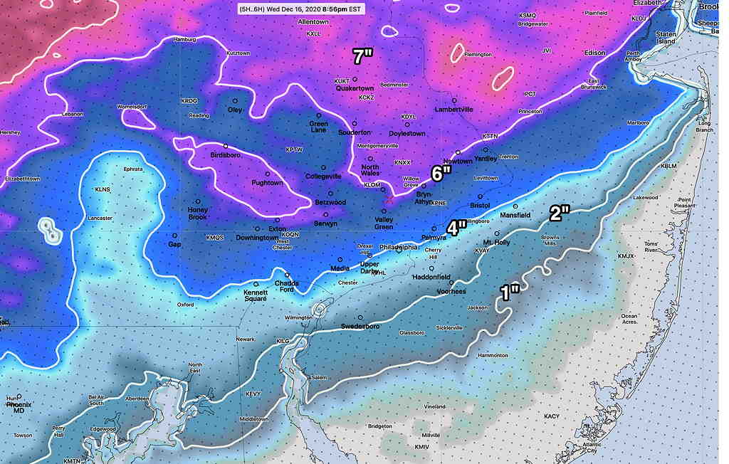
So we’re back to 3-6 inches snow for Philadelphia and immediate western suburbs. I’ve learned something. That’s what makes this so interesting. The NAM isn’t going to cut it going forward (I guess there’s a reason that NOAA has abandoned development since 2018.)
Hopefully, there won’t be further upgrades in the snow totals. Maybe I have to come up with a new blog category, “Mea Culpa”?
I’ve been a fan of your forecasts the past few years, and greatly appreciate your honesty before and after events.
Here in South Philly we had 3-4 inches snow on our backyard walls by 5pm and it’s been sleeting since then. Thanks for sharing your work
Thanks, Brian. I was probably a bit too hard on myself with this post. With all the work I put into this forecast, I was truly surprised to see the NAM so far off on the initial wave of snow accumulations. Now that the change-over has occurred (and within the time-frame predicted), it’s become clearer to me that the NAM built-in algorithms for snow depth are probably faulty. It remains to be seen if the HRRR is correct, since it forecasting more accumulating snow during the pre-dawn hours.
I left work in Levittown at about 5:45 PM, headed home to NE Philly. Your revised forecast was dead-on as far as what I experienced. Hold on to those mea culpas.
Bill, thank you for your note of support. I will hold onto those mea culpas. My area, just outside the city, had at least 3-4 inches before the change-over to sleet, which occurred here about 6 PM. The question tonight will be whether the change back to snow results in further accumulations.
A solid 6 inches in West Chester with a changeover to sleet around 5:15 and then rain at about 6:20. Will there be more accumulation tomorrow?
I just found out about you and am blown away by the thoughtfulness of your forecast.
Paul K in West Chester
Thank you, Paul. Regarding additional accumulation, I’m waiting for the new models to come out. I’m going to wait until the new GFS comes out. It will be after 10:45 PM.
Has the lack of atmospheric data from fewer airplanes in the air affected the quality of the models?
Roger, I don’t know. Current numerical weather models have inherent limitations that far exceed anything that relate to loss of input data of that sort.
No need to apologize…your forecasts are incredibly informative and much better than most media outlets in incorporating new model data as it comes in. Was actually surprised to see some of the higher amounts reported near in Delaware County and the airport. Here in Center City we had about 4” before the changeover to sleet. It makes sense why you went with the NAM as it led the way since the weekend in showing a closer track to the coast and bringing in warmer air aloft than most of the other models indicated. So I still think it’s a useful tool even if its verbatim snowfall totals don’t always pan out. Snow amounts are extremely difficult to predict in Philly, but that’s also half the fun in tracking these things. I greatly appreciate all of your work and insights and look forward to your posts throughout the winter.
Thank you. It sounds like you know more than a bit about weather yourself! Yes, the NAM was ahead of the pack regarding the track.
Huge fan – only forecast we trust.
Thank you!