Category Archives: Winter Storm Outlook

LATEST STORM UPDATE- 9:45 PM

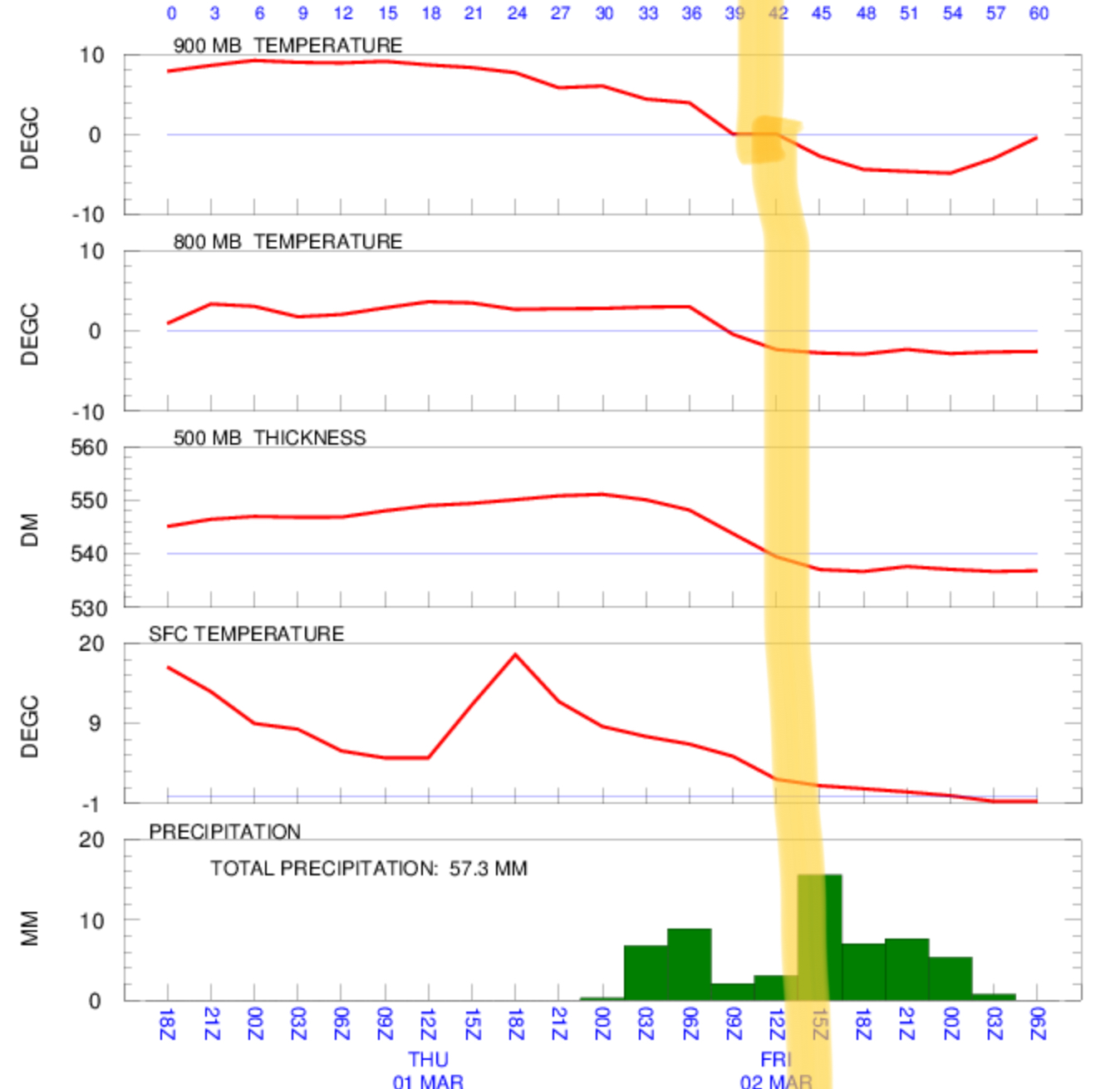
The latest NAM data has become available. Following a rainy night tonight, storm intensification as previously predicted occurs as a secondary low pressure system winds up south of Long Island and moves southeastward.

Temperatures at critical levels of the atmosphere will become cold enough for snow as early as 7-10 AM, so the rain will transition to wet snow at that time.  QPF values as high as 0.70 inches water would ordinarily result in 7+ inches of snow, but for all the reasons enumerated in previous posts,  total accumulations will be much less and difficult to estimate.  Preferential grassy surface accumulations will still hold, with even less on paved and asphalt surfaces. Best guess is still 2-4 inches on grassy surfaces.

Strong winds develop during the afternoon on Friday, with highest winds during the afternoon. The HRRR model has  predicted wind gusts to be as high as 60mph! 

Snow ends about 7 pm.


SIGNIFICANT WET SNOW POSSIBLE FRIDAY

Tonight’s NAM data has just become available.  Details of the coastal storm continue to change, but some aspects have clarified somewhat.

Here’s the current outlook: Rain starts on Thursday late afternoon, becomes very heavy Thursday evening and continues through the night.  Rain continues into Friday daybreak, where things then get interesting—

Temperatures in the critical levels of the atmosphere drop about 8-10 AM Friday morning, with a changeover to wet snow in Philadelphia which may become heavy during the afternoon and last into the evening. 

March snowfall totals are exceedingly  difficult to pin down.

Precipitation may fall as heavy wet snow, but falling during daylight hours in March with ground temperatures above freezing and air temperatures near the surface at or just above freezing will make accumulations difficult to occur.  So accumulations on roadways will likely only occur if it extends into the evening.

That said, the storm may look impressive from the window with wind driven wet snow, but roadways will likely remain wet and slushy for much of the daytime hours.

Still too soon to pin down specifics, but current QPF during the snow chill down is an impressive 0.75 inches water.      Stay tuned.

Below is a meteogram showing temperatures at critical levels falling below freezing about 10 AM Friday— (Philadelphia)


WINTER WEATHER UPDATE- MOSTLY RAIN FOR PHL

The last night’s 06Z  data has become available- both the NAM and GFS models have increased the QPF values to an average of about 0.50 inches water.

This morning’s NAM data also becoming available- the trend is for heavier QPF, and warmer atmosphere!

The NAM has increased the average temperature of the mid-level of the atmosphere to a level that is too warm for snow formation for much of the storm in Philadelphia and immediate northwest areas, as depicted by this map.  (Lower levels of the atmosphere (except at ground level) are at or below freezing, allowing sleet at times.)

Areas south of the red line- mostly rain, maybe some sleet.

Here’s the current best forecast-

Precipitation starts between 4-6 PM today, possibly as light snow or a mix of rain, sleet and snow.

A changeover to rain and rain-mixed with sleet will occur early.  Much of what falls will be rain and possibly some sleet;  at times, some snow may mix in at peak intensity if dynamic cooling occurs.   This event will be mostly wet, not white, in the area depicted south of the red line  in the inset map.

Precipitation may changeover to a brief period of light snow before ending about 2 PM.

Accumulations- zero to a coating, mostly on grassy surfaces.