Category Archives: Philadelphia Weather Outlook

THIS WEEK’S WEATHER

#Philadelphia #weather #PAwx

Sunday Snow Update

A note for those of you who are visiting this site from X.
Due to its highly unbalanced political environment, I’ve considerably cut back auto-posting there. To receive all forecast postings, I recommend following me on mastodon.social or bluesky.social

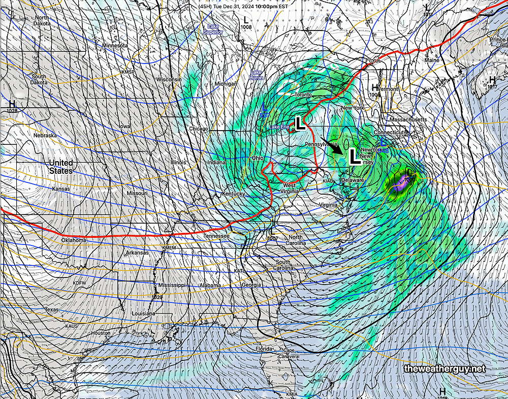
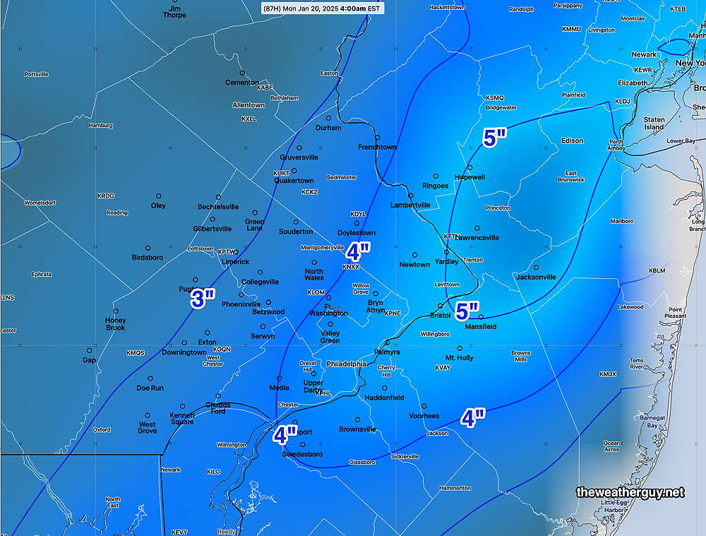
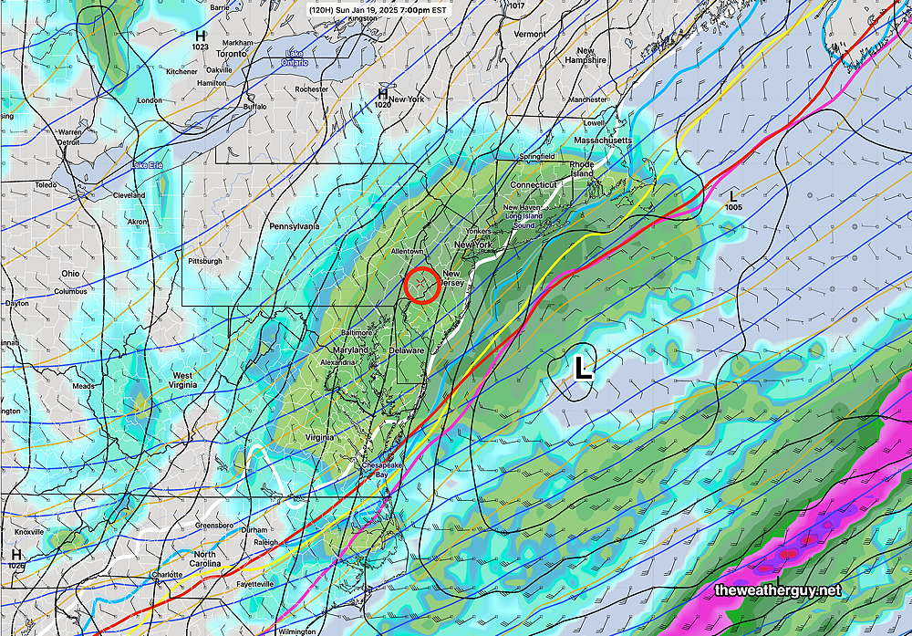
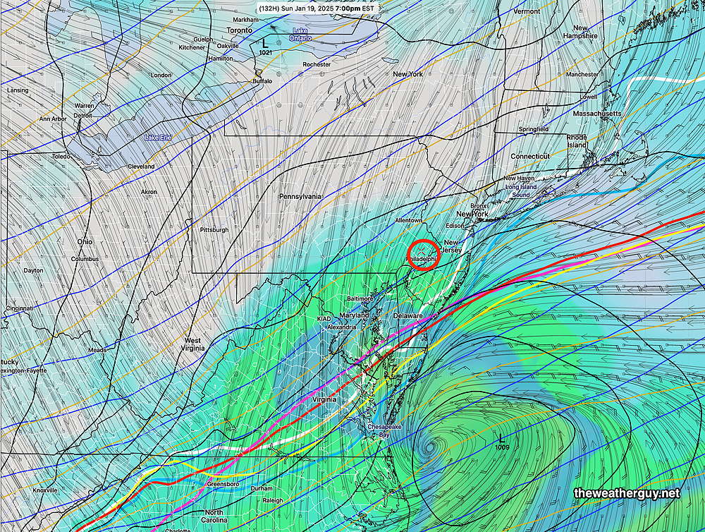
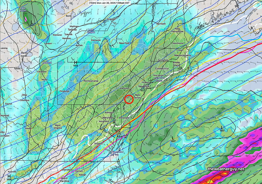
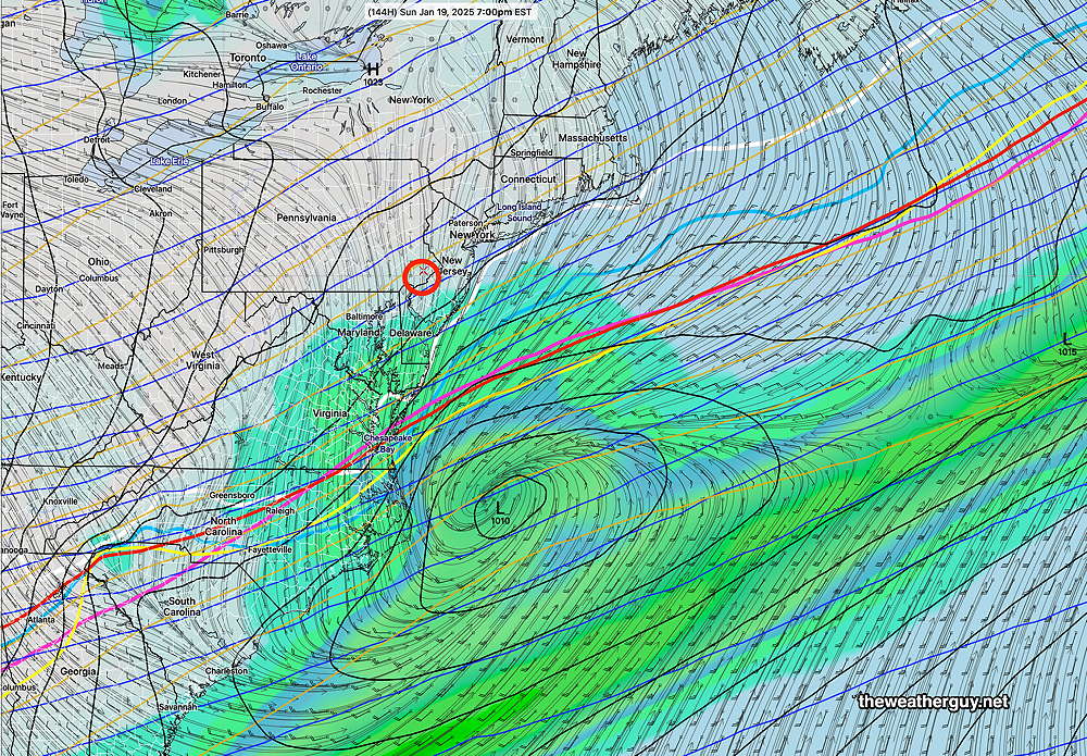
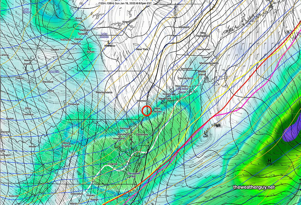
Posted Friday 01/17/25 @ 9:49 AM — This update is a bit delayed to allow me to review some of this morning’s models. Here are the general trends—

  • The NAM has finally joined the other models in forecasting some snow, but it’s snow totals are still low compared to the other models: in the 1-2″ range.
  • The GFS continues to forecast a moderate snowfall (see graphic below)
  • The ECMWF continues to forecast snowfall less than the GFS
  • The Canadian continues to forecast a western track, heavier on precipitation with more rain than snow.

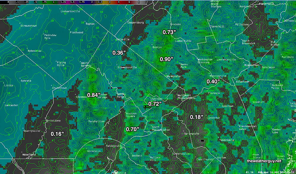
Here’s the latest GFS snow accumulation based on its built-in snow algorithm—

06z GFS forecast snow accumulation by late Sunday evening (Click on image for a larger view.)

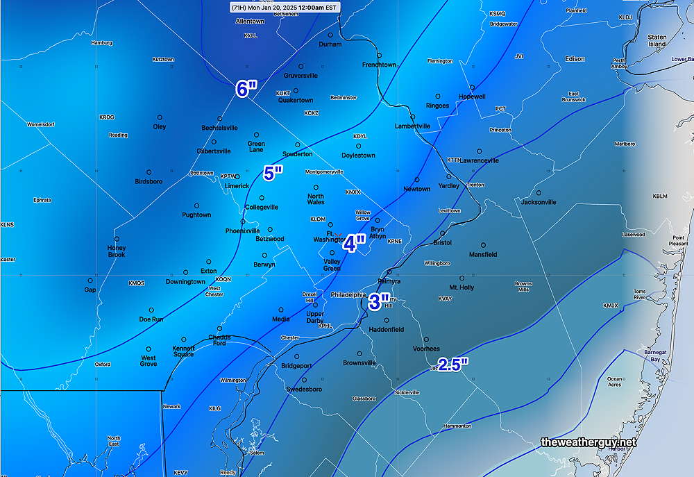
I’m going to leave the heavy-lifting to the model blend (NBM). Here’s its forecast based on all-snow with an 11:1 snow ratio—

13z NBM snow forecast based on all-snow and an 11:1 snow water ratio (Click on image for a larger view.)

The storm looks to be a fast mover, with snow starting as early as mid to late Sunday morning. The Eagles (and more so the Chargers) will have an additional challenge.

Updates later this afternoon after the latest GFS becomes available (after 5:20 PM) with my regular “Weekend Weather Forecast”


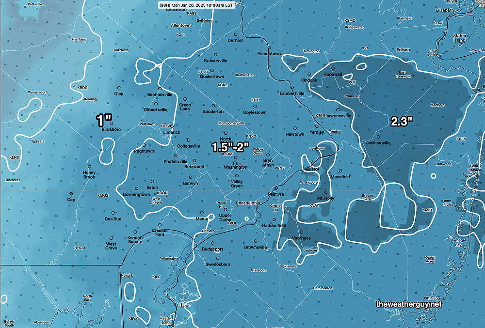
Forecast Update and Sunday Outlook

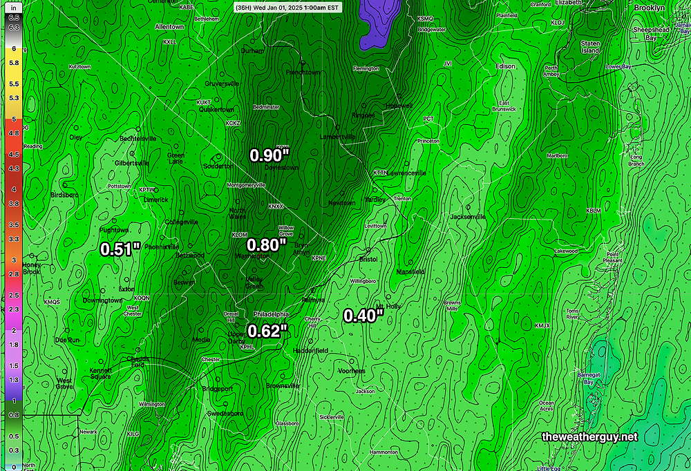
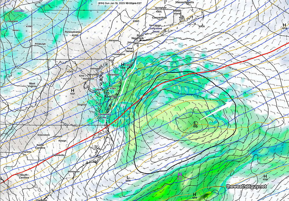
Posted Thursday 01/16/25 @ 6:04 PM — As mentioned below, the latest GFS has become available and it’s forecasting a significant snow storm for us on Sunday. There’s still much uncertainty with this storm but I wanted to share with you the latest GFS forecast snow accumulation—

Today’s 18z GFS snow accumulation forecast for Sunday’s afternoon and night storm (Click on image for a larger view.)

To be balanced, here’s the latest NAM which has the storm totally missing us—

Today’s 18z NAM forecast for 10 PM Sunday. The storm moves off to our east missing us. (Click on image for a larger view.)

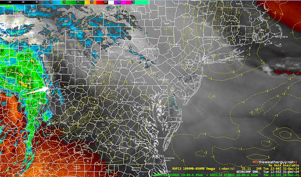
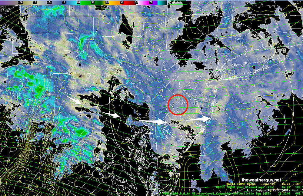
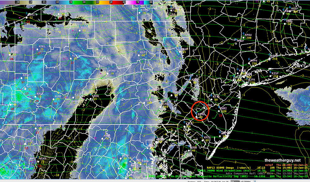
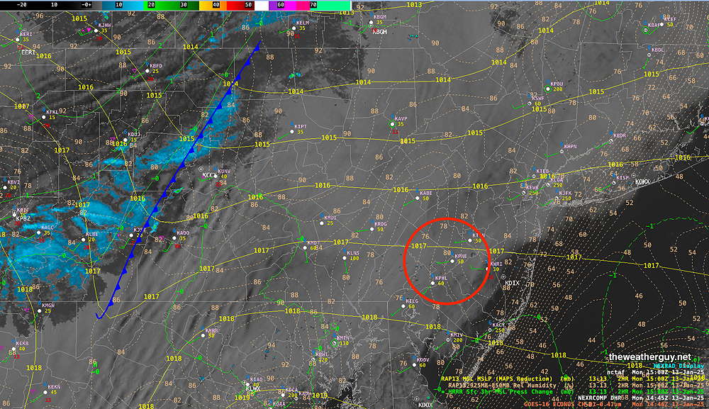
Posted Thursday 01/16/25 @ 5:17 PM — The light snow we’ve been having started a bit earlier than forecast and the coverage is a more widespread than forecast yesterday. The snow should be ending between 10 PM and midnight.

Current Radar/MRMS

~5 PM Radar/MRMS with superimposed RAP model 700 mb wind streams and vertical motion (Omega) (Click on image for a larger view.)

Milder temperatures on Friday will give way to some very light showers on Saturday.

A potential snowfall is still in the cards for Sunday. There’s still a wide range of forecast tracks with the Canadian model showing the most inland (warmer- more rain, less snow) and the ECMWF showing a colder, easterly track with little rain, mostly snow but light accumulations.

Of interest is the NAM which has the storm moving easterly, away from us. giving us neither rain nor snow!

If the model consensus of the model blend is correct, the light snow may start as early as the late morning on Sunday.

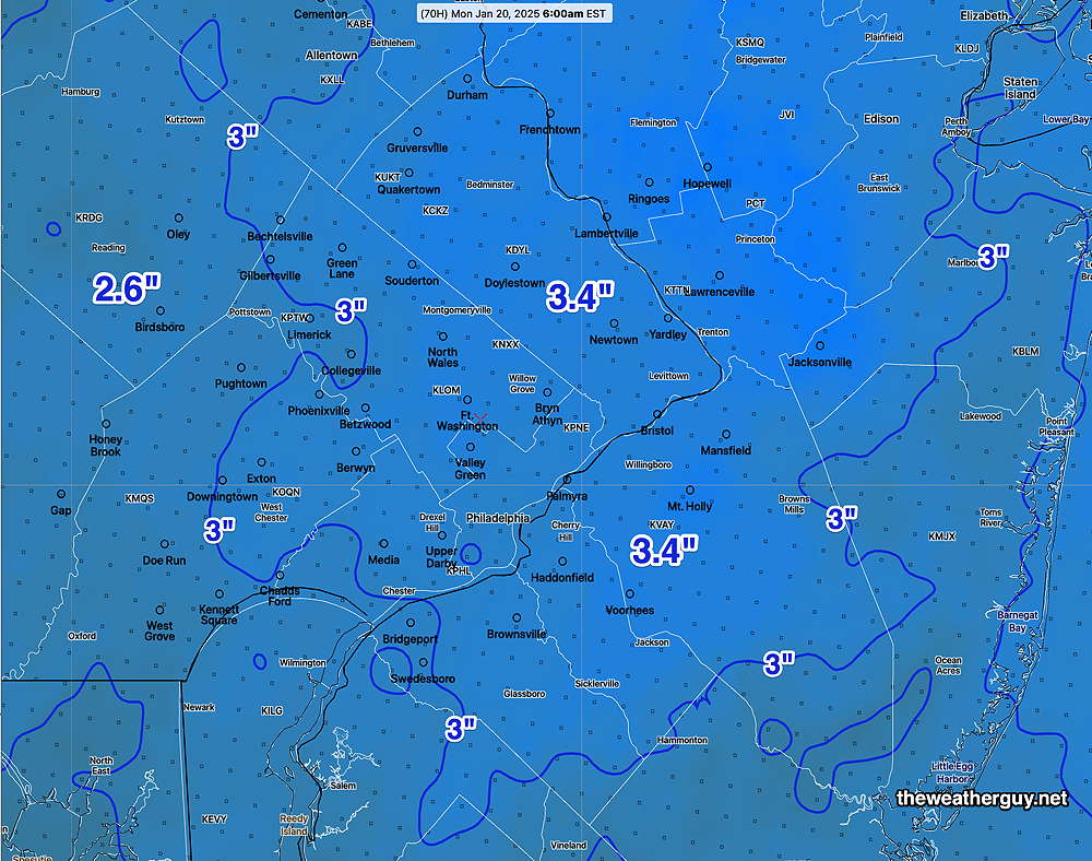
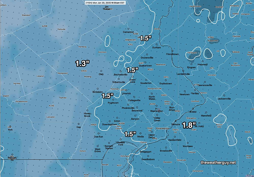
Here’s the latest model blend forecast snow accumulation by Monday morning.

NBM (model blend) snow accumulation based on a 12:1 snow water ratio. (Click on image for a larger view.)

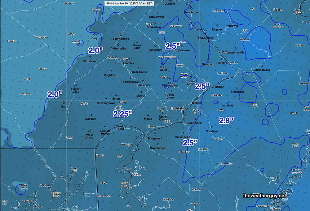
The latest GFS just became available as I write this and it is forecasting amounts similar to the above model graphic, although if the GFS is correct, we might see as much as 3-5 inches of snow.

Stay tuned.

A note for those of you who are visiting this site from X.
Due to its highly unbalanced political environment, I’ve considerably cut back auto-posting there. To receive all forecast postings, I recommend following me on mastodon.social or bluesky.social

Snow Showers this Afternoon – Some Snow likely Sunday

Posted Thursday 01/16/25 @ 10:06 AM — Today’s forecast of snow showers moving in remains intact. Current radar shows considerable light snow, but most is not reaching the ground at this time—

MRMS Radar this morning. Most of the snow is not reaching the ground due to evaporation in very dry air near the surface. Current forecasts for a coating to a fraction of an inch remain intact for today. The only accumulation currently is west of Harrisburg. (Click on image for a larger view.)

Current snowfall expected today is similar to the graphic posted below. The light accumulation is not expected to begin until 3 PM or later.

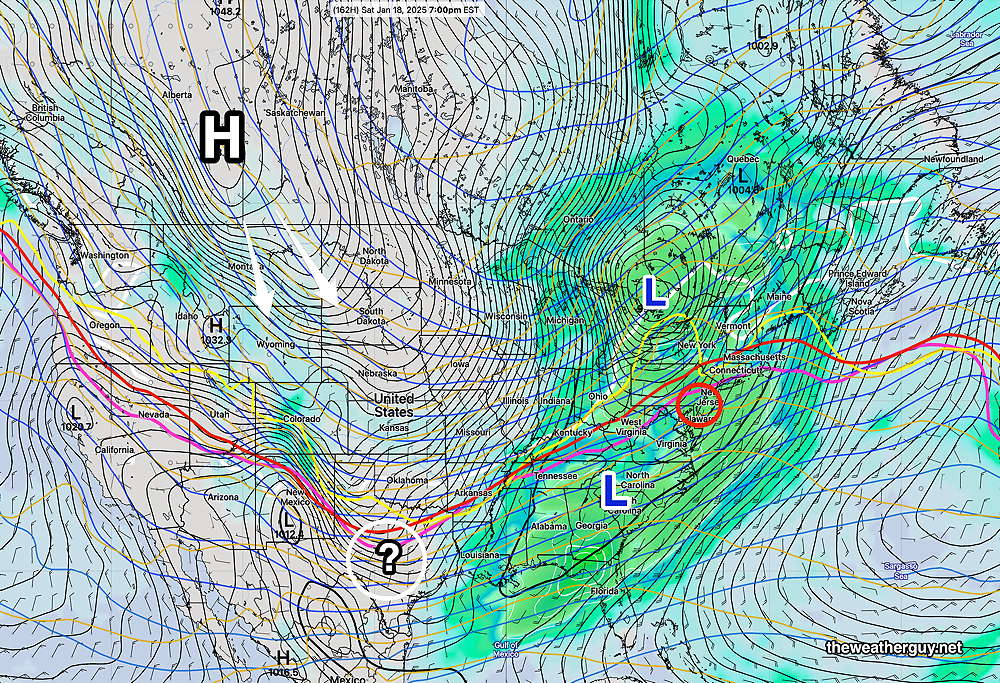
As for Sunday, this looks to be “interesting”, as several models have switched places forecasting snow for us. The usual “track” of the storm is “what’s up in the air”.

The latest ECMWF had been most consistent forecasting snow, but now has backed away from that forecast with a more easterly track. The GFS which had not forecasting snow, is now forecasting some snow for us.

The Canadian models now show an inland storm with plenty of precip, not all in the form of snow. Likely an outlier.

The German ICON is somewhere between the ECMWF and GFS, forecasting some snow. (“Some snow” is 0.5-1″.)

Here’s the latest model blend (NBM) cumulative snowfall forecast, likely too high—

This morning’s 19z Snow accumulation forecast for Sunday. Likely too high. (Click on image for a larger view.)

So there’s still too much uncertainty with this forecast. Hopefully by this evening’s update, things get clarified.


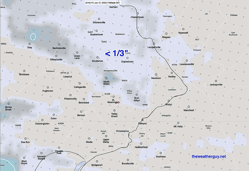
Snow Showers Thursday Evening – Some Snow Sunday

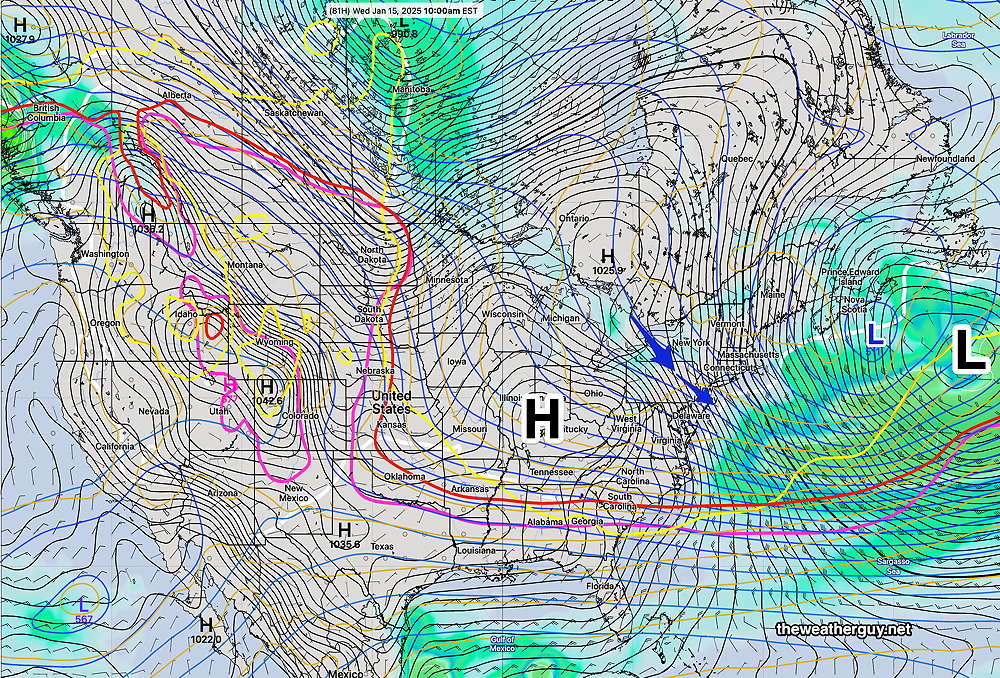
Posted Wednesday 01/15/25 @ 4:47 PM — Today’s models continue with a forecast of light snow/flurries for late Thursday afternoon. Accumulations will be minimal (under 1/3 inch) and spotty. Here’s the model blend forecast for snow coverage Thursday evening—

Today’s 19z NBM forecast accumulation for snow. Many areas will see no accumulation, others maybe a coating (Click on image for a larger view.)

As for Sunday, it appears that light snow may be falling during the Eagles game Sunday afternoon. The latest ECMWF and GFS AI models have similar forecasts and support the deterministic ECMWF forecast. The German ICON model has joined in with a similar snow forecast.

The model that is not on-board is our own GFS model, which consistently shows no snow for us.

It’s too far in future (more than 96 hours) to really talk about details, and it’s beyond the range of many models. But the best guess is for light snow to start as early as 1 PM and continue through the afternoon and evening. By the time the Eagles win, there may be as much as 0.5″ of snow on the ground.

Here’s the latest model blend (NBM) total snowfall forecast—

Today’s 19z NBM forecast for Monday morning showing snow cover. This is very preliminary and there are some trends suggesting it may be higher. (Click on image for a larger view.)

Wed 5:13 PM —Commentary — Despite one or two heavy rains in December and several light snowfalls, I don’t think the pattern of dryness and drought we experienced in the Fall has abated.

Total precipitation, rain and snow-water equivalent, continues to be low. The heaviest precipitation continues to move off to our northwest and to our south. Just something to keep in mind. There’s still time for things to change before Spring.

Posted Wednesday 01/15/25 @ 7:53 AM — Time this morning for just a quick update.
• The chance of light snow (coating) has increased for late Thursday afternoon and evening with a warm front expected to move across our area.

ECMWF forecast for 7 PM Sunday. Precipiation north of the multicolored lines will fall as snow. White line is 32º isotherm. (Click on image for a larger view.)

• A secondary coastal low, hinted at by various models, for later Sunday may bring as 1-3 inches Sunday mid afternoon and evening. I’m basing this forecast on the latest ECMWF and ECMWF- AIFS models. There may be some impact on the Eagles game, based on current timing.

Initially, falling as snow as early as 3 PM and melting on some surfaces, temperatures drop late afternoon below freezing, allowing some accumulation of 1-3 inches of snow. Further details later this afternoon. Stay tuned.


Update- This Week’s Weather

Posted Tuesday 01/14/25 @ 5:00 PM — There have been no major changes in the forecast for this week from my post earlier today. Snow showers look less likely for late Thursday and rain is more likely for Saturday afternoon and evening.

There hasn’t been much clarification on the potential light snow later Sunday into Sunday night. The ECMWF is still forecasting 2 to possibly 3 inches of snow, while the GFS is not showing any snow. With the exception of the ECMWF, the trend is towards little (or no) snow as supported by the NBM model blend.

Of interest is the AI version of the ECMWF, which has joined the regular ECMWF in forecasting some snow for us late Sunday—

12z ECMWF-AIFS forecast for Sunday 7 PM. Some light snow for us. (Click on image for a larger view.)

There’s too much model spread and uncertainty to have confidence in late Sunday’s forecast.


Highlights -This Week’s Weather

Posted Tuesday 01/14/25 @ 7:25 AM — Current highlights for this week’s weather:

  • Colder temperatures will be with us for today, Tuesday, and Wednesday
  • A weak clipper disturbance may bring some light snow showers Thursday evening.
  • Somewhat milder temperatures late Friday.
  • By Saturday, milder but with some rain likely.
  • A strong cold front moves through on Sunday.
  • There remains much uncertainty and model spread regarding low pressure expected to develop late Sunday afternoon. Depending upon the position along the coast, we may see up to 3 inches of snow by Monday morning. We may also see little to no snow.

There remains little agreement with the models regarding the second low expected to form later Sunday. Here’s the latest ECMWF—

Latest ECMWF showing low pressure off the coast but considerable surface activity over PA- 3 inches of snow forecast. Contours- WHITE- 32º surface temp; Critical Thickness for SNOW: RED- 1000m-500mb thickness; YELLOW-1000mb-850mb Thickness; MAGENTA- 850mb-700mb thickness

Here’s the latest AI version of the ECMWF forecast—

The ECMWF-AIFS shows little precipitation near us with the same storm Contours- WHITE- 32º surface temp; Critical Thickness for SNOW: RED- 1000m-500mb thickness; YELLOW-1000mb-850mb Thickness; MAGENTA- 850mb-700mb thickness (Click on image for a larger view.)

The GFS had been forecasting something even stronger than the ECMWF, but the latest run has moved closer to the ECMWF-AIFS,

GFS forecast for early Monday Snow in NJ only. Contours- WHITE- 32º surface temp; Critical Thickness for SNOW: RED- 1000m-500mb thickness; YELLOW-1000mb-850mb Thickness; MAGENTA- 850mb-700mb thickness (Click on image for a larger view.)

Of interest is the ICON which is very similar to the ECMWF—

German ICON model forecast Contours- WHITE- 32º surface temp; Critical Thickness for SNOW: RED- 1000m-500mb thickness; YELLOW-1000mb-850mb Thickness; MAGENTA- 850mb-700mb thickness (Click on image for a larger view.)

.

So, there’s a range of forecasts and it’s too soon to call. Stay tuned.


Monday’s Weather

Posted Monday 01/13/25 @ 10:16 AM — Today’s clouds weren’t in any of the forecasts I heard last night and for good reason: the models didn’t forecast this level of cloud cover for today. The clouds are ahead of the first cold front expected to move through this afternoon—

Visible Satellite image this morning with superimposed RAP model pressure, 850 RH, and 3 hour pressure change. I’ve drawn the position of the cold front. (Click on image for a larger view.)

Based on GFS relative humidity, (but not the built-in cloud algorithms) this cloudiness may last through 4-5 PM today. Some scattered sprinkles or snow flurries are possible late this afternoon, mostly in far western areas.

The possible storms mentioned in yesterday’s Week Weather Outlook are more uncertain, with the GFS still predicting the Saturday rain and possible change to snow Sunday, while the ECMWF has most of it sliding off to our south, similar to the most recent light snowfall we had. With the models in such disagreement, there’s too much uncertainty to forecast this period.

The latest GFS -AI model (“GraphCast-GFS”) still shows a snowstorm possible next Tuesday instead of Sunday. With the limited experience I’ve had to date with the AI weather models, I haven’t seen them to be the magic bullet for predicting snow storms here that they’ve been touted to be.


Previously Posted Sun @ 10:13 AM — —Following two near average cold temperature days (Sunday, Monday), a series of cold fronts will bring much colder temperatures back to our area.

Generally dry, cold, windy weather will be with us through later Friday. Mostly sunny, but clouds at times due to upper air disturbances and instability.

There may be some snow showers Tuesday evening with the first front.

NAEFS mode version shows large high pressure and a tight pressure gradient to the upper/surface low in the Canadian North Atlantic on Wednesday. . Cold, Windy conditions expected. (Click on image for a larger view.)

The position of the cold air boundary will spawn a series of low pressure systems that will affect our area late Friday into Saturday and into the following week.

The first surface storm, late Friday through Saturday, will likely bring rain to our area, but may start as a mix in the northwest suburbs and may end as a mix or wet snow late Saturday or early Sunday.

NAEFS forecast for Saturday. Large storm north of the Great Lakes and a second low developing near Georgia will bring mostly rain on our region on Saturday, possibly starting as a mix Friday night in the northwest suburbs. Depending upon how the large H (high) in Canada moves in, and the development and track of the second low near Georgia will determine if we get snow on Sunday. The( ? ) denotes another area of potential storm development for the following Monday and Tuesday. (Click on image for a larger view.)

This week’s cold dry weather will likely be a prelude to more active weather systems after Saturday. Possible snow in the period Sunday through Tuesday.


THIS WEEK’S WEATHER

#Philadelphia #weather #PAwx

Clipper Snow Update

Posted Friday 01/03/25 @ 4:13 PM — We’re having some light snow in the Philadelphia area; the snow moved in about an hour earlier than previously forecast. Current radar shows the heaviest band developed just west of Philadelphia, closer to last night’s HRRR but definitely not forecast by today’s models, which had the banding to our south.

Here’s current radar—

Radar loop courtesy of WeatherTap.com

Some additional snow may move in, based on current radar and RAP model analysis showing areas of upward motion (positive Omega)

Combined Radar and MRMS with RAP model overlay (Omega, 700 mb winds) (Click on image for a larger view.)

I’m waiting until the latest GFS becomes available (in about an hour) to update the snow outlook for Monday. I hope to have another update before 6PM.


Posted Friday 01/03/25 @ 9:55 AM — One more thing. Regarding Monday’s storm, there’s still uncertainty in the exact track, with the latest ECMWF keeping the snow maxima further south—

ECMWF forecasts a more southerly storm track, reducing snow totals here from the NBM posted earlier this morning. (Click on image for a larger view.)

Friday’s “Snow” and Monday’s Snow Storm Update

Posted Friday 01/03/25 @ 9:15 AM —As I said yesterday, “Clipper snowfalls are notorious for being over-forecast (and occasionally under-forecast).” Such is the case today. After reviewing last night’s trends and this morning’s early models, here’s the scoop on today’s clipper snowfall—

  • Light snow starts as early as 3-4 PM western suburbs, early enough that temperatures will be above freezing initially, reducing accumulations.
  • Snow accumulations will be spotty and occur mostly on grassy surfaces.
  • The trend for the ‘heavier’ banding has been for to occur just south of Philadelphia, where general snowfall will be about 1/2 inch, most likely on grassy surfaces.
  • Any light snow ends about 10 PM or earlier.

Here’s the latest HRRR (12z) which just became available—

This morning’s HRRR shows spotty accumulations and low totals for today, Friday. Banding occurs just south of the city. (Click on image for a larger view.)

As for the larger storm expected Monday, the models continue with forecasting a moderate snowfall, beginning before daybreak Monday and continuing through the day.

Unlike today’s clipper, where the snowfall is within model ‘noise error’, Monday’s storm is looking more certain. This storm is still more than 90 hours in the future, so expect some things to change.

Here’s the latest NBM snowfall forecast by Tuesday morning—

Today’s 12z NBM-based snowfall accumulation forecast. (Click on image for a larger view.)

I’ll be updating later today with my regular “Weekend Weather Forecast”.


Snow—Friday Evening and Sunday-Monday Update

Posted Thursday 01/02/25 @ 9:29 PM — A quick update. The latest higher resolution models are becoming available. The HRRR and NAM/NAM-NEST show the clipper moving in as early as 4-5 PM Friday and lasting just a few hours.

The earlier start, when temperatures are above freezing may limit accumulation in some areas. The latest HRRR snow accumulation occurs in a narrow band—

Tonight’s 00z HRRR snow totals for Friday by 10 PM (Click on image for a larger view.)

With model forecasts, the placement of the heaviest band snow should never be taken literally. As an example, tonight’s NAM-NEST shows less snow and the heavier banding occurs south of the city.


Posted Thursday 01/02/25 @ 5:21 PM — A clipper disturbance approaching Illinois now is expected to strengthen slightly as it receives upper air support just south of the Philadelphia area towards Friday evening.

Clipper snowfalls are notorious for being over-forecast (and occasionally under-forecast). Here’s the latest NBM total snowfall by Saturday morning. (This may be over-done)—

Today’s 18z NBM forecast snow accumulation Friday night into Saturday morning. Possibly over-done.(Click on image for a larger view.)

Another disturbance is expected to develop and move to our south late Sunday evening through Monday. The models are now consistent forecasting a moderate snowfall here. Here’s the latest NBM snow totals—

18z NBM-based snowfall accumulation by Tuesday morning (Click on image for a larger view.)

The above forecast for Monday will undoubtedly change. Stay tuned.


Snow Friday Evening

Posted Thursday 01/02/25 @ 10:44 AM — I guess I didn’t make it clear that the major snow posted earlier at 9:16 AM is for Monday.

But there’s additional snow possible late tomorrow (Friday) through the late night Friday associated with a clipper disturbance. Clipper disturbances often are difficult to forecast accurately. Here’s the forecast snow totals for Friday evening/night—

Friday evening’s clipper snowfall (Click on image for a larger view.)

Significant Snow Looking Increasingly Likely (Monday)

Posted Thursday 01/02/25 @ 9:16 AM — The trend, first picked up by NBM yesterday, shows a change towards a more significant snowstorm in the Philadelphia area. The models are still trying to resolve this system, either as a main low that redevelops along the coast or as a series of lows that pass to our south.

Latest 06z GFS forecast for Monday shows a series of low pressures systems. The critical thickness lines (red, magenta, yellow) are all south of us, indicating all snow. (Click on image for a larger view.)

The trend, in contrast to previous forecasts, is for a more northern system with the precipitation shield covering our area, especially areas south of Philadelphia, South Jersey and Delaware where a major snowfall is now predicted.

Here’s my latest snow forecast based on the latest ECMWF—

00z ECMWF – based snow totals by Monday late afternoon. (Click on image for a larger view.)

This forecast is still evolving. Additional changes are likely. I’ll have another update between 5 and 6 PM this evening. Stay tuned.


Snow Sunday Evening through Monday?

Posted Wednesday 01/01/25 @ 5:22 PM — There’s still great uncertainty regarding the track and timing of a storm expected to pass to our south sometime late Sunday into Monday. We will be on the cold side of this storm and the model blend (NBM), which tends to be conservative with snow forecasts in past seasons, is predicting measurable snow for us.

Many models show the storm too far to our south for significant snow. The AI models show either no snow or very little for Philadelphia, but greater amounts possible in Delaware and South Jersey.

(We’ve had very little snow the past two years and I’ve spent many hours programming model data and fine tuning graphics to display snow totals with little use for it. So I’m inclined to share the current snow forecast despite it being too soon to take it seriously. )

Here’s the latest NBM snow forecast. Don’t hang your hat on these numbers—

Today’s 18z NBM forecast snow accumulation (mean) by Tuesday. (Click on image for a larger view.)

Weather Outlook- Today through Sunday

Posted Wednesday 01/01/25 @ 11:46 AM — Cold air is filtering in slowly and the most noticeably weather feature will be the decreasing temperatures today through early Friday.

For today, Wednesday, considerable cloudiness is forecast due to instability. Windy conditions also expected.

An arctic front will move through Friday with clouds; no showers/flurries currently expected. Cold temperatures in the 30s are expected for highs over the weekend.

There is the possibility of light snow in the Sunday through Monday time frame. The models have shifted back and forth with the trend for the storm to move to our south, possibly just clipping our area with a light snowfall. At most, the forecast has been for 2-3 inches, but that’s not currently the most likely forecast.

The ECMWF Ensemble (statistical) model shows high uncertainty in position of the low pressure system and an average (mean) position too far to our south for much or any snow.

The ECMWF ensemble shows high uncertainty in the speed and position of the low pressure system expected to develop. (Click on image for a larger view.)

It was hoped that the AI models might improve forecasts, but over the past few days, they have been as changeable as the deterministic models regarding this potential snowfall.


Wed 11:35 AM —Forecast Review — Several things were noted about yesterday’s forecast. First, there was much more sunshine during the day than had been forecast. The rain moved in as had been forecast but moved out much faster than forecast.

Rainfall was considerably higher than predicted by the models and the current standard, the model blend (NBM), forecast much less rainfall than we had. The convection (thunderstorms) were forecast by the models, but the intensity not so much.

Here’s the actual rainfall totals, from the MRM, from New Year’s Eve—

MRMS rain-gauge measured rainfall combined with rain-gauge calibrated and interpolated radar-based summary of ACTUAL RAINFALL RECEIVED. Color shading is in inches. Line contour numbers are in mm. (25.4 mm= 1 inch)      (Click on image for a larger view.)

New Year’s Eve – New Year’s Day Forecast

Posted Tuesday 12/31/24 @ 8:31 AM — I’ve updated the timing of the rain tonight, based on the latest NBM which just became available.

Posted Tuesday 12/31/24 @ 7:43 AM — The first of several cold fronts for this week will move through this evening, associated with a secondary low pressure system expected to develop over eastern Pennsylvania. This low will move northeastward.

Water Vapor image with superimposed RAP model vertical motion – Omega- and composite radar at 7:55 AM (Click on image for a larger view.)

Light rain begins near the city 6 PM-7 PM, but some light scattered activity possible as early as 5 PM. It will taper off in the city about 12 AM – 2 AM, earlier to the south and west.

The system will be fast moving and much of the energy (and rain) will be enhanced to our north. Total rainfall is expected to be in the 0.25-0.4 inch range.

Wednesday, New Year’s Day, will start partly cloudy, but become quite cloudy by noon. It will be quite windy with gusts approaching 40 mph.

The wintry weather for the time frame Sunday-Monday looks like less of a sure thing, based on the latest models. It looks like any storm will be less developed.


New Year’s Eve Forecast Update

Posted Monday 12/30/24 @ 5:32 PM — Tuesday will may start out sunny in some areas, but clouds should predominate by late morning and into the afternoon, except at the Jersey Shore, where it will remain sunny into later in the day. There may be a break of sun again in some areas mid afternoon before the clouds roll back in.

Light rain moves in from the south and west as early as 5PM-6 PM and tapers off about 2 AM Wednesday morning. There’s a range of forecast rainfall intensities, depending upon the exact location of the secondary coastal low formation.

Some models have as little as 0.25 inches of rain, while others are showing as much as 1 inch. The model blend (NBM) is showing about 0.80 inches with a band of heavier rainfall in the city.

Today’s 18z Total Rainfall forecast for Tuesday night (Click on image for a larger view.)

For snow lovers, there’s an increasing signal for possible snow Sunday night into Monday. Well into the future, but I’m keeping an eye on it.


MRMS rainfall amounts for Sunday night’s storm posted.


Previously Posted Mon @ 11:47 AM — —This week will be a transitional week weather-wise, from above average temperatures and an upper air ridge to somewhat below average temperatures by late Thursday into the weekend.

Today, Monday, will be sunny.

The next system to affect us will be a low pressure system that spawns a secondary low near the coast on Tuesday night. The timing for New Year’s Eve couldn’t be much worse, but at least it will be rain and not frozen precipitation—

GFS forecast for Tuesday at 10 PM. Secondary low forms in northern NJ. (Click on image for a larger view.)

Clouds move in Tuesday early afternoon. Current timing is for light rain to move in about 6 PM Tuesday evening, heaviest towards midnight ending about 2-3 AM.

A windy day expected for New Year’s Day with clouds in the morning and more sunshine during the afternoon.

ECMWF-AIFS forecast Cold air! (Click on image for a larger view.)

Colder Thursday and much colder Friday through Sunday.

There’s a hint for a possible wintry storm Sunday or Monday from the GraphCast GFS-AI model and to a less extent from the ECMWF-AIFS. Hardly a sure bet. Stay tuned.


THIS WEEK’S WEATHER

#Philadelphia #weather #PAwx

Weekend Preview

Posted Friday 12/27/24 @ 9:53 AM — No large changes in the forecast for this weekend. Two low pressure systems will affect us—

Current satellite water vapor image with superimposed RAP model 500-1000 mb thickness lines (yellow), Mean Sea Level Pressure isobars (black contours) potential vorticity (fine violet contours) with superimposed MRMS RADAR. (Click on image for a larger view.)

Rain begins Friday night, likely after midnight, (some scattered activity earlier) and through the day Saturday. Tapers off Saturday night.

Rain early Sunday morning has a break in action Sunday afternoon, in time for the Eagles game. Heavy rain Sunday night.

Here’s the latest ICON model forecast for Sunday afternoon. The rain stays to our west—

Today’s 06z ICON model forecast for Sunday at 1 PM. The latest ECMWF has the rain even further to our west. (Click on image for a larger view.)

Check back for more details for my regular Weekend Weather Forecast, probably posted during this evening.


Weekend Weather Outlook

Posted Thursday 12/26/24 @ 4:42 PM — A southwesterly flow of increasingly warm and moist air along with an approaching low pressure system will bring periods of cloudiness to our area Friday afternoon along with an increasing chance of scattered showers by Friday evening and heavier rain by midnight.

Here’s the current water vapor image showing the low pressure systems and the conveyor belt of warm moist air—

Current satellite water vapor image with superimposed RAP model 500-1000 mb thickness lines (yellow), Mean Sea Level Pressure isobars (black contours) potential vorticity (fine violet contours) with superimposed MRMS RADAR. Two areas of low pressure are shown along with an area of warm moist air. (Click on image for a larger view.)

Mild temperatures on Saturday will be accompanied by periods of rain. Areas of fog and lighter, scattered showers Saturday night.

For Sunday, the ECMWF still shows a dry period during the Eagles game before some heavy rain moves in for the evening and night time. Supporting the hiatus in the rain is the AI model version of the ECMWF and the NAM. The latest Canadian RGEM also shows this break in the rain before heavy rain returns for Sunday night. We may even see some sun mid afternoon.

RGEM Cloud Cover Forecast Sunday afternoon—

RGEM Cloud cover forecast for 3 PM Sunday (Click on image for a larger view.)

However, the latest GFS suggests a faster approaching system with rain moving in about 1 PM during the Eagles game Sunday afternoon. The rain continues through Sunday night. Too soon to tell, but the GFS tends to bring systems up to fast from the southwest.

The models are cranking out 1.6 to 2.2″ of total rainfall by Monday morning with greater amounts far northwest in Lehigh and Berks counties.


Weather Outlook

Update Wed 12/25 8:41 PM — A quick update. Thursday looks to be sunny but still cold. A bit milder on Friday, with sunshine through high cirrus clouds. The weekend is still looking cloudy and wet, but with very mild temperatures, in the upper 50s. Some moderate rain is possible late Sunday.
Unfortunately, New Year’s Eve and New Year’s Day are looking wet. Another plunge in temperatures Thursday.


Posted Wednesday 12/25/24 @ 9:23 AM — Moderating temperatures through the weekend. A moisture ‘conveyor belt’ is setting up for the weekend with possible rain Saturday and Sunday. Timing remains uncertain and there may be a rain-free window for the Eagles game early Sunday afternoon. Another wet period is possible around New Years Eve or New Years Day.


Wed 9:17 AM —Forecast Review —Looking back to the snow yesterday morning, the areas of maximum snowfall occurred on either side of the I-95 corridor, instead of being in the northwest suburbs, as had been forecast by the models.

Here’s the MRMS precipitation summary which records rain and snow-water equivalent —

MRMS rain-gauge measured rainfall combined with rain-gauge calibrated and interpolated radar-based summary of ACTUAL RAINFALL RECEIVED. Color shading is in inches. Line contour numbers are in mm. (25.4 mm= 1 inch)      White numbers is snowfall based on a 10:1 ratio. (Click on image for a larger view.)

Tuesday Morning – Light Snow Update

Posted Monday 12/23/24 @ 5:48 PM — Not much change with the latest models. Cold temperatures at the surface through 11 AM and “critical thickness” temperatures for snow are still forecast, although a change to sleet or freezing rain toward the end can’t be ruled out.

Current satellite water vapor image with superimposed RAP model 500-1000 mb thickness lines (yellow), Mean Sea Level Pressure isobars (black contours) potential vorticity (fine violet contours) with superimposed MRMS RADAR. (Click on image for a larger view.)

Light snow start about 7 AM and tapers off by noon, as temperatures rise above freezing. The latest HRRR forecast for snow totals—

Today’s 18z HRRR. Yellow, red and magenta “thickness” lines are south of us at 11 AM, supporting snow as the precipitation type. Approxiimate snow totals are showin. (Click on image for a larger view.)

Light Snow Tuesday Morning

Posted Monday 12/23/24 @ 10:33 AM — This morning’s models continue with a forecast of light snow as a weak disturbance drops down from the northwest. The trend with some models has been for a more northern placement of the the light snow, while the higher resolution models continue to forecast a coating to 0.75 inches, with the upper range in the northern suburbs.

Light snow is expected around 7 AM and last through about 11 AM, as temperatures rise above freezing.

Here’s the latest HRRR—

Snow forecast based on the 12z HRRR (Click on image for a larger view.)

Originally Posted Sun @ 6:39 PM — —The current cold pattern will continue on Monday, but temperatures will slowly moderate through Christmas/Chanukah. as the current dip (trough) in the jet stream changes into a ridge—

NAEFS 200 mb winds (jet stream level) by Thursday showing developing ridge. (Click on image for a larger view.)

No major active systems are expected, but several models are showing some light snow or flurries Tuesday morning, mostly in northern sections—

Latest GFS shows areas to the north likely to see snow flurries or light snow. (Click on image for a larger view.)

It looks like it will be cold enough for snow and at most only 0.5″ is currently forecast in these northern sections. (It should be noted that the latest ECMWF has some light snow further south but the AI version of the ECMWF shows no snow at all on Tuesday.)

The rest of the week is uneventful, with a gradual warmup. A system may bring rain the end of next weekend, possibly lasting through New Years Day.

When it comes to weather, things can change, so stay tuned.