FYI, NOAA model data, usually available on their website called “NOMADS“, has been inconsistently available today.
NOAA, over recent days, has changed SSL certificates and has attempted to move their data over to Akamai’s CDN (Content Delivery Network).
This changeover has been fraught with difficulties over recent days. With NOMADS not working, NOAA’s backup server is overwhelmed.
It’s been difficult to get a complete download of the NAM, GFS and other models. With little data available, it’s been tough to do a forecast.
Updated Fri 8/26 8:23 AM — Many of last night’s models have significantly downplayed the chances of showers today in our area. The NAM-NEST continues with very widely scattered showers around 5 PM.
Update Thu 08/25 @ 8:11 PM — The weather has been on easy auto-pilot the past few days with increasingly warm and humid conditions.
Friday will have the warmest temperatures of this week with temps in the low 90s in many areas.
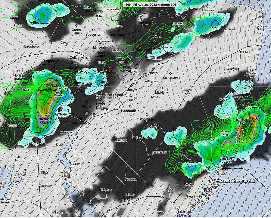
A weak front will move through Friday afternoon. Most of the US models have kept any showers to the far north of Philadelphia. But, this afternoon’s NBM, Canadian RGEM, and the ECMWF shows some light showers and thundershowers developing west of Philadelphia in the mid afternoon and moving eastward.
Canadian High Resolution (HRDPS) forecast for 4 PM Friday (1 hour Precipitation rate and 3 Hour accumulated Rain) (Click on image for a larger view.)
This is a relatively new development, since the previous days model runs had no showers in our area.
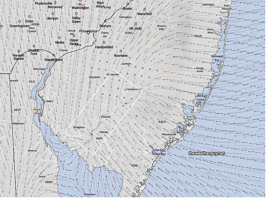
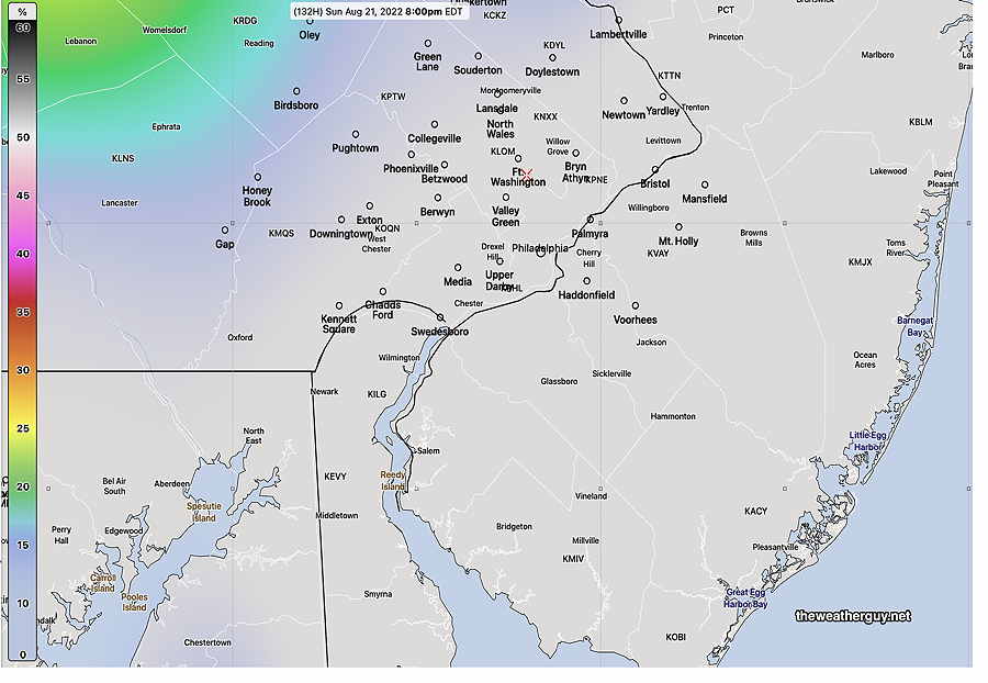
A bit of uncertainty for the weekend forecast, as the high pressure system behind the front will move off to our north creating an easterly flow here. Some degree of cloudiness and possibly some afternoon showers are possible as the models have an easterly flow converging with a westerly flow.
NBM surface winds Saturday 3 PM. The wind streams clearly show an area of horizontal wind convergence, forcing air upward causing showers to develop. (Click on image for a larger view.)
The Jersey shore may be most affected by this easterly flow. The uncertainty in the weekend forecast should clarify over the next day. Stay tuned.
Quiet and increasingly hot
Update Tue 08/23 @ 5:40 PM — The balance of the week will be influenced by a very weak upper flow. (The main jet flow is north into Canada.)—
NAEFS statistical “mode” Friday forecast jet stream level contours at 250 mb. Slow, stagnant flow over the US. The little wave in southwestern PA is a weak front. (Click on image for a larger view.)
Increasingly warm and humid through Friday. High temperatures upper 80s Wednesday and low 90s Thursday and Friday. A weak front moves through Friday evening. The long range models show little chance of rain in the coming week.
Update Tue 08/23 @ 5:38 PM — A more zoomed in version of the accumulated rain graphic—
MRMS accumulated rain. Contours are in millimeters. 25.4 = 1 inch. Color code is in inches with legend at the top. (Click on image for a larger view.)
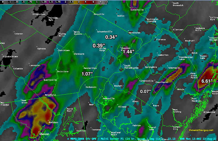
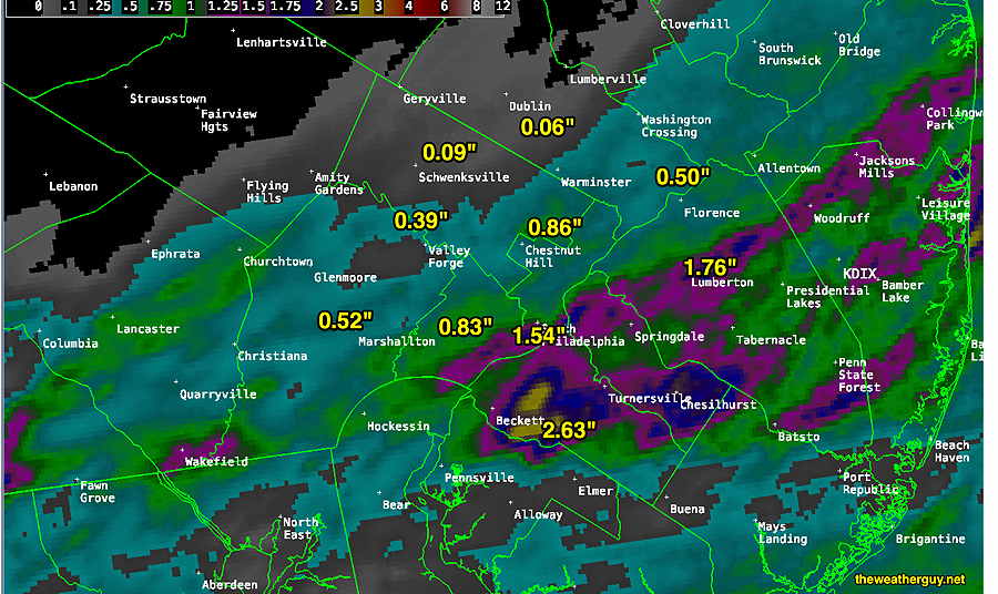
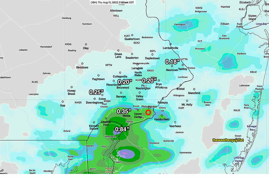
Update Tue 08/23 @ 9:05 AM —Many, but not all areas, received significant rainfall since Sunday afternoon. Here’s the MRMS rainfall totals—
MRMS 48 hour rainfall totals. Contours are rainfall in mm. Color coding is in inches. (Click on image for a larger view.)
Yesterday afternoon’s 19zHRRR did well in predicting the additional rain and thunderstorms that evening.
Additional Showers and Storms Monday Evening
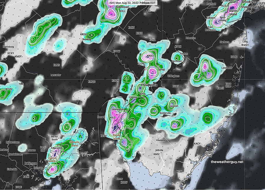
Update Mon 08/22 @ 5:56 PM —This morning’s HIRESW (high resolution models) weren’t all on-board with much additional rain this evening.
However, the 19z HRRR shows some significant rains/thunderstorms popping about 7-8 PM in the immediate PHL area.
19z HRRR showing some heavy showers/thunderstorms 7 PM (Exact location of heaviest rain shouldn’t be taken literally) (Click on image for a larger view.)
Monday showers not a drought-breaker
Previously Posted Mon 10:20 AM —
Additional showers and maybe some thunderstorms during the day today (Monday), but the latest HRRR and RAP shows much of the activity today before 1 PM, with another round this evening.
Much of the remaining rain forecast by this morning’s models will fall to our west, north and south, with only about 0.3″ additional in the immediate PHL area.
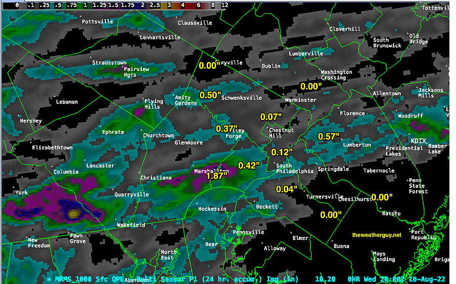
Last night’s rain was disappointing, except in some areas (not forecast).
MRMS past 24 hour rainfall accumulation as of 8 AM Monday. Much of the area had much less than forecast. The rain maxima over Chestnut Hill/Germantown was partly from the localized rainfall that went through Sunday afternoon. (Click on image for a larger view.)
Not much of a drought-breaker so far, But we’ll have to see what develops later today and where.
Update Fri 08/19 @ 10:43 AM — Here’s the update I had planned to provide last night. 🙄
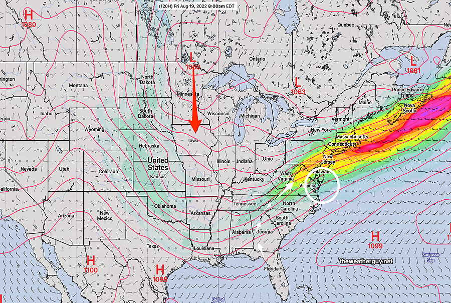
The overall forecast is playing out as expected. Low pressure will develop and move off the Virginia coast Saturday, missing our area. A second low in the Minnesota will move in late Sunday and Monday—
Friday morning: Current water vapor with RAP model contours. (Click on image for a larger view.)
Saturday looks good with some scattered clouds.
Some uncertainty whether some light showers move in mid to late afternoon on Sunday or whether it holds off until the evening hours as the second low approaches from the west. Increasing humidity over the weekend, especially by Sunday.
Models crank out anywhere from 0.5- 1″ of rain for late Sunday through Monday. Will have to see… These dry spells are tough to break.
More Moisture–> More Rain?
Update Thu 08/18 @ 8:31 AM —A stationary front to our south will slowly move north as a warm front over the next few days.
WV image Thursday AM with stationary front (drawn) to our south. Disturbance # 1 will move to area X and then offshore on Saturday. Disturbance #2 will move in late Sunday into Monday. Increase in clouds, heat and humidity. (Click on image for a larger view.)
An increase in showers and humidity over the next four days, but diffuse weather pattern will make timing in advance difficult. As mentioned in previous day’s posts, the models are showing best chance of showers here Monday into Tuesday, BUT latest GFS keeps parts the Delaware Valley dry! I’ll update Thursday evening.
Pop up showers possible late Wednesday afternoon
Updated Tue 8/16 10:57 PM —A change in Wednesday’s forecast based on tonight’s models. Low pressure affecting Maine tomorrow will rotate some upper air disturbances through our area late Wednesday afternoon with some scattered pop-up showers and a fewweak thunderstorms. Likely time is between 4:30 and 6 PM. Not all areas will see rain.
Little chance of rain
Updated Tue 8/16 5:47 PM —Our San Diego type weather will continue. Unfortunately, the trees and flowers are getting thirsty.
The earliest chance of rain appears to be late Sunday afternoon or evening. (Some areas far northwest will see some brief showers Wednesday evening.)
So what is the chance we’ll see more than 0.10 inches of rain Sunday evening? —
NAEFS 6 hour rain probability of more than .10 inches of rain 2 PM- 8 PM Sunday. Large areas will receive less or nothing. (Click on image for a larger view.)
FYI, this is a probability for a six hour period. Typically, in non-drought situations, a probability of at least 25-30% in a six hour period usually means some rain.
OK, that was for 0.10 inches.
What about the chances for greater or equal to 0.25 inches of rain Sunday evening?—
NAEFS 6 hour rain probability of more than 0.25 inches of rain 2 PM- 8 PM Sunday. Most areas will receive less than 0.25″ (Click on image for a larger view.)
Addendum Tue 8/16 8:04 PM —Reviewing today’s GEFS, ICON and GFS, there’s a strong signal for some substantial rain early morning hours next Tuesday.
Dry until the weekend
Update Mon 08/15 @ 8:56 PM — A dry flow aloft and an easterly wind at the surface will keep things dry and pleasant through Friday. The weekend may have some light showers. We may need to wait until late Sunday or next Monday for some rain.
Current water vapor image with 250 mb (jet stream level) wind contours (orange lines) shows a dry flow over our area that may persist through Friday. White arrows show the flow over us(Click on image for a larger view.)
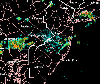
Update Mon 08/15 @ 9:12 AM — The showers have made it closer to Philadelphia than last night’s models had forecast. The models still have them falling apart as they move closer.
NEXrad radar loop 8 AM Monday. I always get a kick out of the TV weather people’s expression “we’re tracking the storms” Weather is not like a a commuter train with “next stop, Philadelphia”. It’s a highly dynamic complex process. The above radar loop is a great example. At quick glance, it looks like the rain is on its way into the city. A can’t-miss situation. But the rain was hitting a dome of very dry air and the storms fell apart, as the models predicted. (Click on image for a larger view.)
Evolving Weather Pattern Change
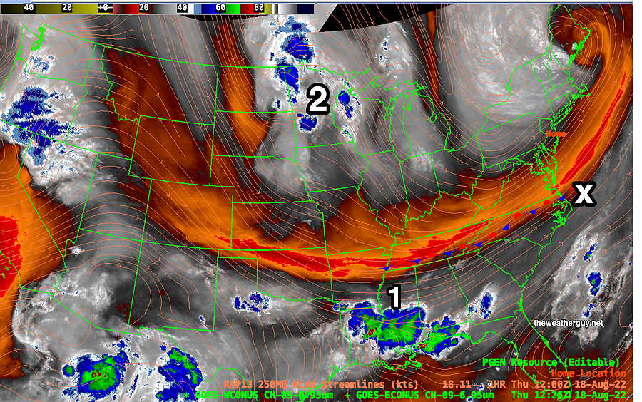
Previously Posted Sun 9:54 PM —
As mentioned in my weekend post, the upper low pressure system that had been expected to provide some rain for us Monday and Tuesday will be positioned in a location that gives us little or no rain!
However, things appear to be changing further in the overall jet flow this week, with a new dip in the jet flow in the center of the country, positioning a jet streak just to our south by Wednesday—
NAEFS forecast for Friday morning. Upper low drops southward in center of the US. Right entry region of jet streak (white circle) Moisture flow comes up form the southwest. (Click on image for a larger view.)
With all that, the southeastern US looks to get most of the rain this week. Not much rain for us showing in the extended range…yet. Things are showing signs of change.
Here’s how things look for Tuesday–
GEFS Tuesday 2 PM forecast. Plenty of rain…just not around here. (Click on image for a larger view.)
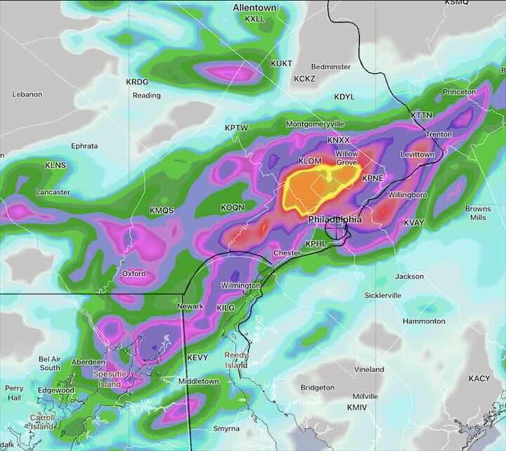
Compare the above actual rain amounts above to the forecast of the experimental LAMDAX model shown here. Not perfect, but not bad!! Better placement than the NAM-NEST.
The experimental LAMDAX isn’t available every day, and when available, only web type low resolution graphics are released; no raw data is available outside of NOAA.
Rain Wednesday night into Thursday morning
Updated Wed 8/10 10:33 PM — Tonight’s models are showing considerably more rain tonight than previously forecast, in line with the experimental LAMDAX model. Many areas, but not all, may receive 0.4 to 0.8 inches. Every model shows a bullseye of localized heavy rain, but the location varies by model. Here’s the latest NAM-NEST, which is most extreme with its bullseye —
NAM-NEST. The bullseye of heavy rain is 4 inches, probably a modeling error.
Updated Wed 8/10 9:08 PM — Updated with the latest LAMDAX precip forecast which just became available below.
Updated Wed 8/10 5:54 PM —Last night, while a very few areas received a substantial rainfall, most areas last night only received a paltry amount. Even the area around Citizens Bank Park only received about 0.30″ yet it caused two rain delays.
Rainfall totals for last night (Tuesday evening/night), according to the MRMS—
MRMS total 24 hour rainfall (Tuesday evening/ night) (Click on image for a larger view.)
As for this evening (Wed), there’s lack of model agreement about where a low pressure system will develop along the stalled frontal boundary that moved through yesterday. This translates into a wide range or forecasts, most with rain south of the immediate PHL area.
The consensus forecast based on the NBM—
NBM total rainfall forecast Wednesday night into early Thursday morning. Most of the rain falls from Philadelphia and southward. (Click on image for a larger view.)
We already know this forecast will be off….the same models forecast rain already beginning in some areas right now, but nothing to be seen on radar and I see blue skies outside my window.
Most of the rain will be gone by 8 AM, but a few areas may have some lingering showers, all gone by 10-11 AM, except in eastern NJ. Not a drought-buster.
Just for the heck of it, here’s the latest experimental LAMDAX high resolution model forecast, showing a very different location of the heaviest precipitation . (The LAMDX looks like it’s being developed and groomed for the next generation of models, likely to be ready for operational release in 2024. It’s still experimental and not finalized.) —
Today’s experimental 12z LAMDAX showing much different location of heaviest precip axis. The LAMDX has limited availability with only pre-made graphics, no raw data available. Click on image for larger view.
Paltry rainfall for Tuesday evening
Updated Tue 8/09 8:37 PM — We did’t get a drop of rain. Maybe this time —
Radar at 8:39 PM
Update Tue 08/09 @ 6:03 PM — I think we have the answer: the storms fell apart as they approached. My neck of the woods didn’t get a drop. I don’t need to change the headline title of this post which I have kept since Monday evening.
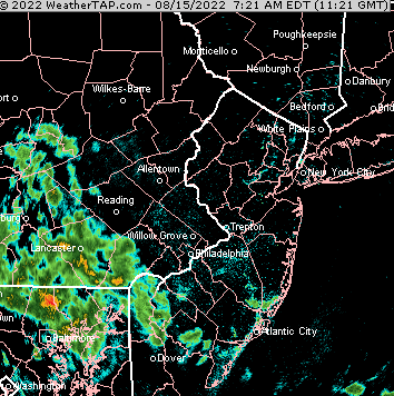
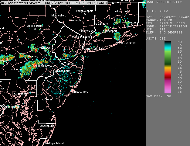
Update Tue 08/09 @ 4:24 PM — Some storms have broken out to our west. The question (that will be answered soon): will they fall apart and diminish as they approach Philadelphia and New Jersey?
Courtesy of weathertap.com (Click on image for a larger view.)
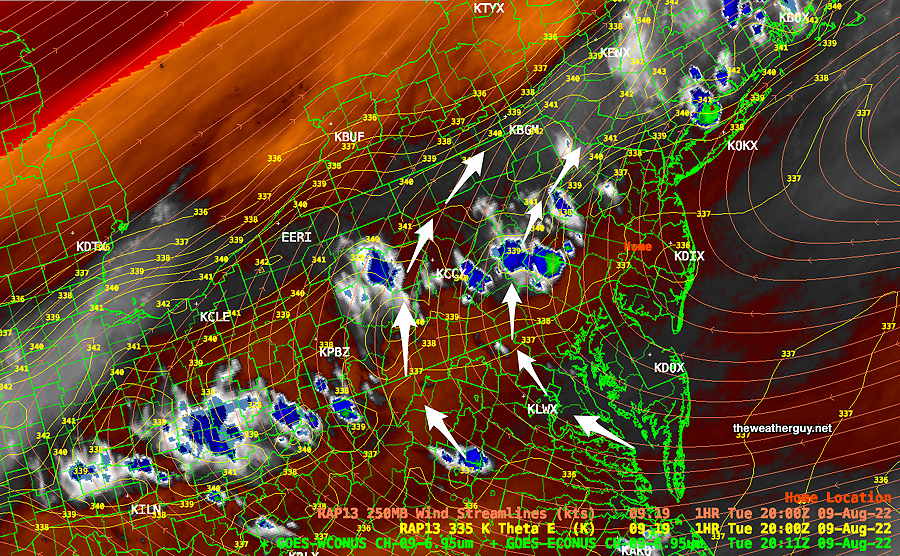
The upper air pattern is working against storm formation with strong anticyclonic flow—
Water Vapor Image at 4 PM shows considerable dry and a very warm air mass (orange coloration) Some popup storms, aided by mountain orographic lift, near the Poconos. But the overall jet level flow is anticyclonic (clockwise) as shown by the white arrows, greatly reducing the chance of showers developing here. (Click on image for a larger view.)
This afternoon’s 18z HRRR shows minimal showers moving through between 7 and 9 PM—
18z HRRR shows minimal, spotty showers moving through between 7 and 9 PM. (Click on image for a larger view.)
A Drought?
New Jersey has just issued a “drought watch”. We’re ‘watching’ here in Pennsylvania too!
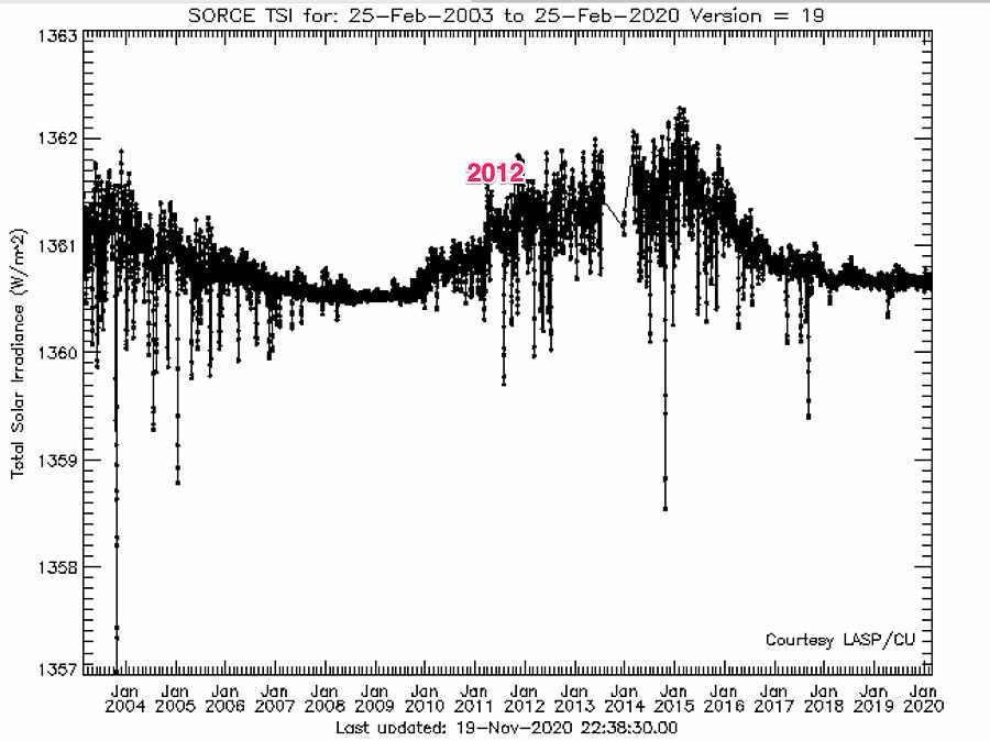
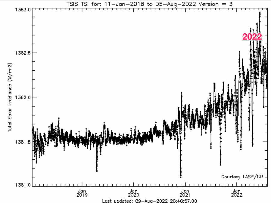
There’s talk about this is the first drought here in about 10 years. Any coincidence that we’re in a similar phase (increase) in the ~11 year sunspot cycle? I don’t think so.
I have no idea about the precise mechanism causing drought conditions. BUT each solar maxima increases total solar irradiance reaching our planet by over 1 Watt/M2, which clearly must raise the temperature of the atmosphere. I’m conjecturing that an increase in upper atmosphere temperatures causes drought conditions. Superimpose that increase in temperature with climate change and the effect could be significant.
The study of sunspot cycle and Total Solar Irradiance is performed by the TSIS satellite and previously by the SORCE satellite, operated by the Laboratory for Atmospheric and Space Physics.
Here are summary plots showing the increase in irradiance for the past and current sunspot cycles—
SORCE data (Click on image for a larger view.)TSIS data (Click on image for a larger view.)
I went back through my old posts from 2012. I’ve been linking the sunspot cycle with dry conditions for 20 years.
Updated Mon 8/08 10:55 PM — Tonight’s high resolution models are showing the possibility of tomorrow’s showers being an even greater disappointment. Many areas may receive little or no rain.
Update Mon 08/08 @ 8:03 PM — Our severe heat wave will end tomorrow evening as a cold front moves slowly through. Despite high CAPE values and high precipitable water values, the models are cranking out only scattered showers and thunderstorms.
Total rainfall for most areas will be in the paltry 0.2-0.4″ range. Some areas will have less and a few up to 0.75″ in our area. I offered an explanation for the lack of rainfall earlier in this post.
NBM forecast rainfall—
NBM 1 hour accumulated rainfall at 9 PM. This 1 hour snapshot of the rainfall gives a sense of the amounts and coverage. (Click on image for a larger view.)
There’s a range for the onset of the showers: as early as 4-5 PM, but with most of the activity between 7 PM and 11 PM.
We may receive some additional rainfall Wednesday evening with a secondary cold front.
Update Mon 08/08 @ 8:36 AM — Monday’s weather will be notable for the much higher dew points (70º-75ª) than the high temperatures (92-94º).
The max heat index (maximum “apparent temperature”) according to the NBM at 3 PM —
06z NBM apparent temperature (heat index) at 3 PM Monday. (Click on image for a larger view.)
Most models keep any pop-up thunderstorms to our far northwest today. But with the increase in humidity, a pop-up thunderstorm in our area can’t be ruled out. There is a large upper air disturbance that will rotate through our area, visible on water vapor imagery —
WV image for 8:16 AM showing disturbance near Great Lakes. The greatest chance of any popup storms is just our northwest (see yellow isentropic contours). The strong anticyclonic curvature of the upper winds will work against any storm formation.
Yesterday, storms tried to develop but failed—
Cumulus with strong vertical growth on Sunday about 12:30 PM. (Click on image for a larger view.)
Previously Posted Sun 8:19 PM —
The current heat wave continues through Tuesday afternoon. Little relief from dry conditions.
A change is on the way Thursday —A significant dip in the jet stream on Thursday will result from high pressure building in to the eastern third of the country—
GEFS jet stream winds (250 mb) Thursday evening showing significant trough over the eastern third of the US. (Click on image for a larger view.)
Before we get to Thursday, we have to deal with a complex situation late Tuesday and Wednesday.
Between Tuesday evening and Thursday a cold front will struggle to move through.
Ordinarily, we’d expect heavy thunderstorms and heavy rain (much needed!) with a cold front moving into very warm humid air. And I wish I could be confident that the immediate Philadelphia area will receive that heavy rain we need.
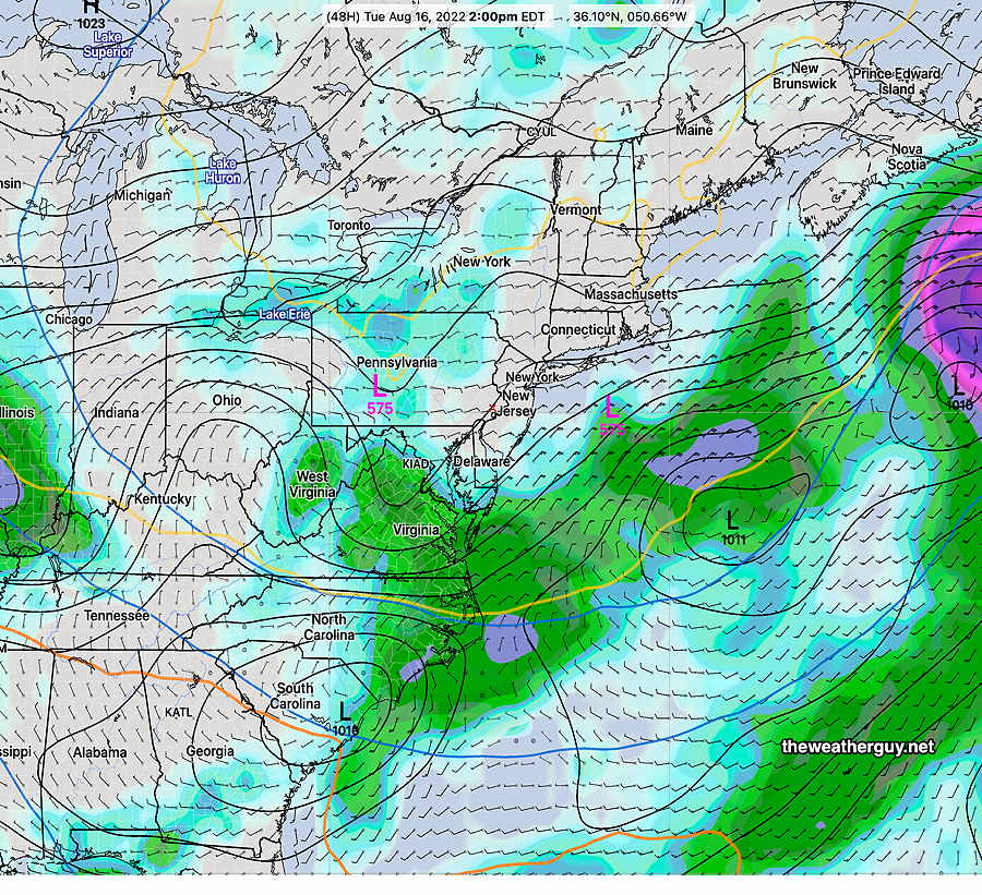
But the GFS shows a complex frontal passage with the upper air ridge hanging tight on Tuesday night with the front stalling—
GFS forecast for Tuesday evening 11 PM. Shows showers/thundershowers but the immediate PHL area not receiving all that much as the upper air ridge (orange 576 thickness line) still hangs back over central PA. The slowing front will have several areas of low pressure develop along it. (Click on image for a larger view.)
The front makes another move through Wednesday night with more showers and thunderstorms Wednesday afternoon and evening.
Zooming in on 8 PM Wednesday night, that pesky 576 thickness line hangs back after the front moves through and and the immediate PHL area appears to get short-changed in the rain department.
GFS Forecast for Wednesday 8 PM shows the immediate PHL area receives a paltry amount of rain with the front! The 576 thickness line hangs back. (Click on image for a larger view.)
Next Thursday through Sunday look great. But if you’re hoping for relief from lawn watering, I’m afraid it may not happen. Should surface low pressure develop in a slightly different position, things might change.