Update Sat 12/24 6:31 PM — Forecast for Sunday below on track. A significant warming trend towards the end of the week with some rain next weekend.
Update Sat 12/24 8:12 AM — Still expecting considerable periods of cloudiness (with some sun) today, as instability develops and and areas of vorticity revolving around the deep low pressure system pass through the area. Cold and windy.
The latest models suggest some sun with periods of clouds as well on Sunday. More sun Sunday than today. Winds diminish in the afternoon.
A warmup expected next weekend with some rain.
The very cold weather for this weekend has been well-advertised. The circulation around the intense low that is now in Canada will continue to affect our weather this weekend.
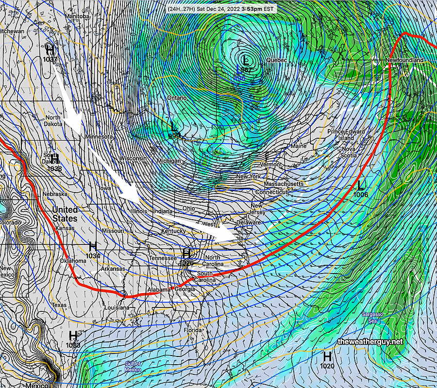
Today’s 18zNAEFS forecast for Saturday afternoon shows intense low in eastern Canada with its cyclonic circulation affecting our area on Saturday. This continues into Sunday. (Click on image for a larger view.)
Saturday
A mix of sun and clouds. Very windy. Instability cloudiness may be considerable at times, especially northwest of the city.
High temperature 16.6º sd 2.6º NBM model – for location Blue Bell, PA (high spread of 2.6º due to uncertainty in cloud cover)
Sunday
Mostly sunny. Less windy in the afternoon. Continued very cold.
High temperature 25.0º sd 1.7º NBM model – for location Blue Bell, PA
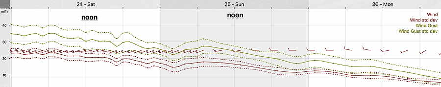
Winds
NBM wind meteogram for Blue Bell PA (Click on image for a larger view.)
Update Sun 12/18 @ 9:12 AM — Expect considerable instability cloudiness, similar to Saturday, to move in from the west about 11 AM – noon today. Also updated this week’s Winter Storm page.
NOAA and the NWS has just released the preview version (called the parallel run) of the new NBM model (version 4.1) this past Thursday, and major improvements in precipitation type forecasts suggests that I lean heavily on this new NBM model for the storm’s precipitation type forecast.
From National Weather Service /NOAA—
Improvements in NBM Model 4.1 – inclusion of additional Australian Global and Canadian models and NOAA’S new HIRESW-FV3–
“Improvements in winter weather guidance for snow, ice, freezing rain, and unconditional precipitation type through the increase in [ensemble] membership (18 to 100 members) and leveraging direct model precipitation type guidance averaging direct model precipitation type guidance.”
“Usage of high-quality Quantitative Precipitation Estimates (QPE) observational and long sampled climatological data sets (e.g., the Multi Radar/Multi Sensor System (MRMS) and Multi-Source Weighted-Ensemble Precipitation (MSWEP) for calibrating probabilistic quantitative precipitation forecasts”
Update Sat 12/17 @ 5:30 PM — We did have the cloudiness today. Sunday will likely be similar to Saturday regarding clouds, possibly even cloudier in the afternoon. Colder. Forecast below still holds.
Update Sat 12/17 @ 5:33 PM — Winter Storm page updated for storm expected Thursday to Saturday.
Update Sat 12/17 @ 10:31 AM — Last night’s models are less emphatic about cloudiness this afternoon.
Update Fri 12/16 @ 5:51 PM — Updated Saturday and Sunday forecast below to reflect new model forecasts. Changes are highlighted.
Our weather this weekend will be influenced by a slow moving upper air low and a slowly departing surface low that gave us the rainy weather Thursday into Friday. High pressure will be building in, but disturbances rotating around the upper low will cause windy conditions and some occasional cloudiness.
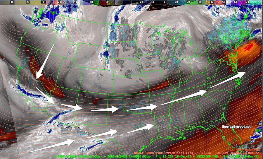
Water Vapor image shows upper air configuration—
Water Vapor Image Friday morning shows the upper low approaching the Great Lakes area. The arrows depict the general location of the jet stream. (Click on image for a larger view.)
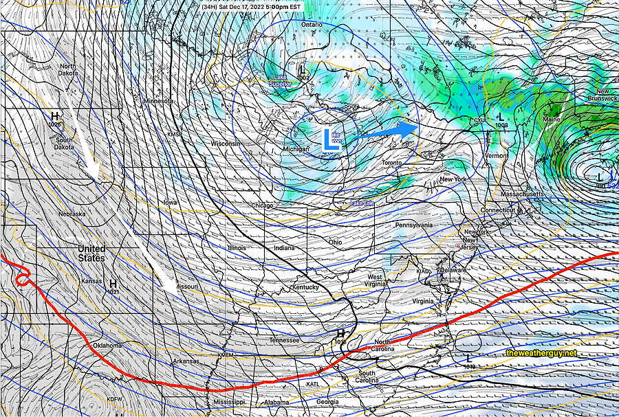
Friday’s 12z GFS forecast for Saturday at 5 PM. The upper low hasn’t moved that much eastward and the surface low is still off the coast of Maine. Cold high pressure will be sinking southward into Missouri. The circulation around the upper low will continue to affect us. (Click on image for a larger view.)
A colder pattern is setting up for the weekend and the coming week with cold high pressure pushing the jet stream to the south of us.
I’m keeping my eye on significant coastal storm that is forecast to form in the late Thursday through early Saturday time frame. The impulse expected to trigger this storm is way off in the Pacific right now and it’s too soon to consider it a reality.
At the same time, this is the first time in a long while where a white Christmas here is a distinct possibility. It currently looks to be a rain–> snow storm for us. Stay tuned.
Previously Posted Fri 12:07 PM —
Saturday
Mostly sunny in the morning, considerable instability cloudiness in the afternoon, especially west of the city. Windy/breezy and cold. Wind chills in the low 30s.
High temperature 40.1º sd 1.8º NBM model – for location Blue Bell, PA
Sunday
Sunny and cold. A period cloudiness in the early afternoon. Still breezy. Wind chills in the 20s!
High temperature 37.0º sd 1.8º NBM model – for location Blue Bell, PA
Update Sun 12/11 @ 9:53 — Forecast remains on track for today, Sunday. Heaviest rain here and at MetLife (Giants) Stadium will be from 2-6 PM. Rain totals here only about 0.20 inches or less; In East Rutherford NJ, it will be about double that amount. A bit windy.
Update Sat 12/10 9:04 PM — Tonight’s early models continue forecasting light showers moving in during the early morning hours, from west to east. Total rainfall about 0.25”
Areas north of Allentown may start as light snow changing to rain.
The period Thursday through Friday continues to look interesting. Stay tuned.
Update Sat 12/10 @ 10:46 AM — The latest models have some scattered light rain moving in as early as the morning hours Sunday, but the steadier light rain moves in between 1 PM and 4 PM Sunday. Total rainfall still light, only about 0.15 inches. (somewhat heavier rain/mix Allentown and north)
Models show the possibility of non-accumulating mixed precip in northern Montgomery and Bucks counties Sunday morning before a changeover to all light rain.
As for the potential storm Thursday into Friday, forecast differences in amount of cold air translate into significant differences in storm development and track. The ECMWF continues with a cold and deep coastal system, while the Canadian and our GFS have a much less developed upper trough. Stay tuned.
Previously Posted Fri 5:12 PM —
This weekend … and interesting weather next week
High pressure affect our weather on Saturday and will move off to the northeast on Sunday as low pressure moves north in Canada. A weak secondary low will form off in the Atlantic. Strong storm possible next week.
Saturday
Sunny weather for most of the day here, with some high cloudiness moving in between 2 and 4 PM. Light easterly winds.
High temperature 42.8º sd 1.9º NBM model Blue Bell, PA
Sunday
Low pressure in Canada will move north of us on Sunday as it transfers its energy to a weak low pressure system expected to develop in the western Atlantic.
Rain moves about noon and some rain is expected during much of the remainder of the day. The rainfall is expected to be light, less than 0.20 inches total.
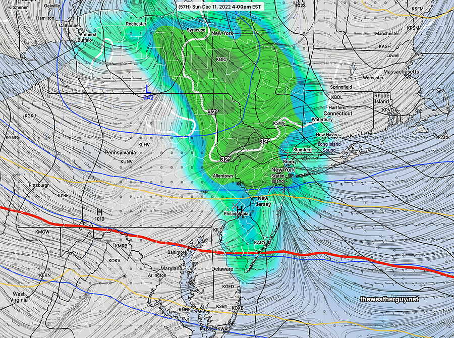
Today’s 12z GFS shows precip in our area at 4 PM. The red 540 thickness line is south of us, indicating the upper atmosphere is cold enough for snow, BUT lower layers of the atmosphere are expected to be above freezing. No snow expected here at this time. (Click on image for a larger view.)
Temperatures in the upper atmosphere are expected to be fairly cold and there had been some forecasts showing cold air moving in that would change the light rain to a mix or light snow, especially northwest. The mixed precip and snow is no longer forecast in our immediate area.
High temperature Sunday 43.1º sd 1.6º NBM model, Blue Bell, PA
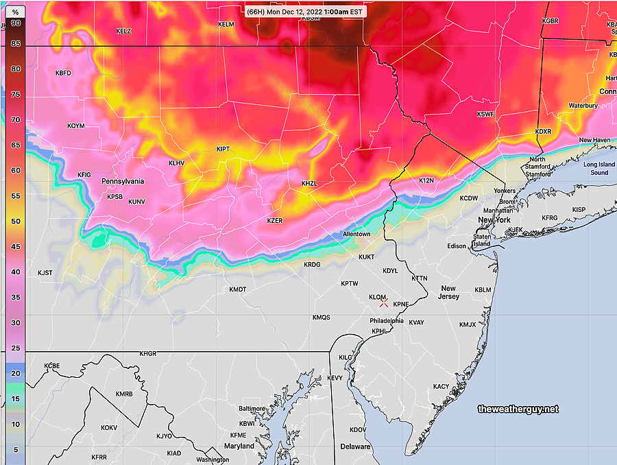
The NBM shows a high chance of some snow well to our north—
Today’s 12z NBM shows high probability of some snow (>.10 inches) well north of our area on Sunday. (Click on image for a larger view.)
Colder air moves in on Monday.
The ECMWF still shows some snow flurries possible here Monday afternoon.
The week ahead..
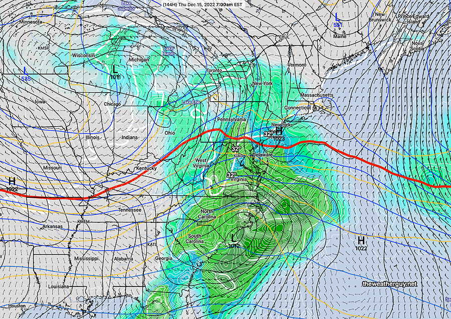
A deep storm is expected to move across the country Wednesday through Thursday. Some interesting weather looks to be in store for us late Wednesday into Thursday. Stay tuned.
12z GEFS forecast for next Thursday morning showing a possible changeover to snow in our area as low pressure develops along the coast. Too far in the future to be sure of anything. (Click on image for a larger view.)