Updated Fri 07/07 @ 9:26 AM — Another quick update. Latest NBM and HRDPS is a bit faster with the showers and thundstorms moving into Philadelphia. As early as 2-4 PM, although peak is 4-7 PM.
Todays’ 12z NBM shows showers/thunderstorms at 4 PM (Click on image for a larger view.)
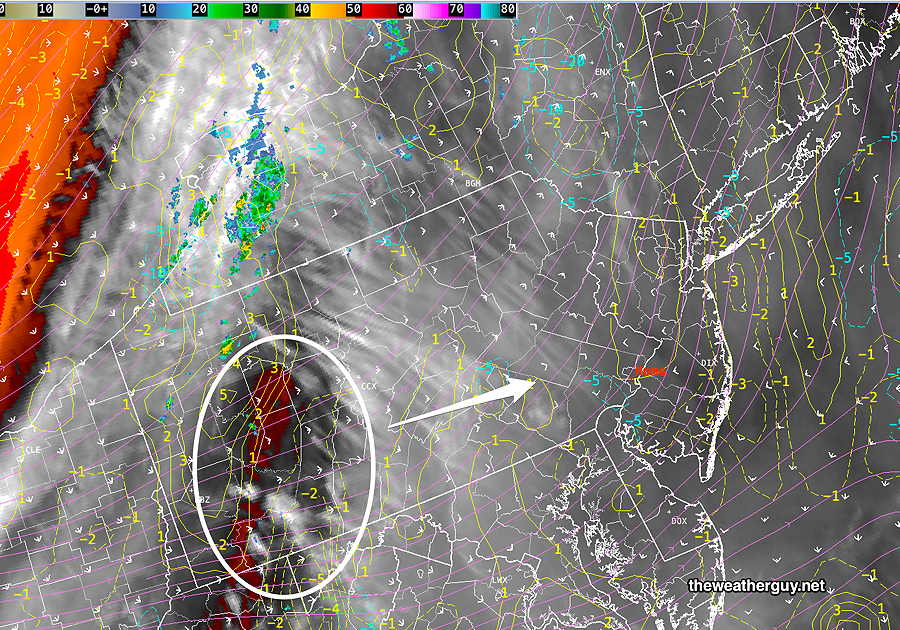
Updated Fri 07/07 @ 8:32 AM — A mid level disturbance in western PA this morning will slowly move eastward today, triggering showers and thunderstorms.
This morning’s satellite Water Vapor image with wave-type disturbance in white circle. (Click on image for a larger view.)
The showers/thunderstorms will be mostly west of a line from Reading to Allentown during the afternoon, but last night’s models suggest some may make it into Philadelphia between 4 PM and 10 PM. It does not appear likely that the activity will move far into NJ
An advancing trough will bring partly sunny skies Saturday with showers possible again in the afternoon and evening. Sunday looks to be wet with potentially heavy rain as low pressure develops ahead of the trough.
Check back early evening for my weekly “Weekend Weather Forecast”.
Friday’s Weather
Updated Thu 07/06 @ 8:19 PM —A few thundershowers popped up in Reading and Allentown this afternoon, with a few others in Montgomery and Bucks counties—
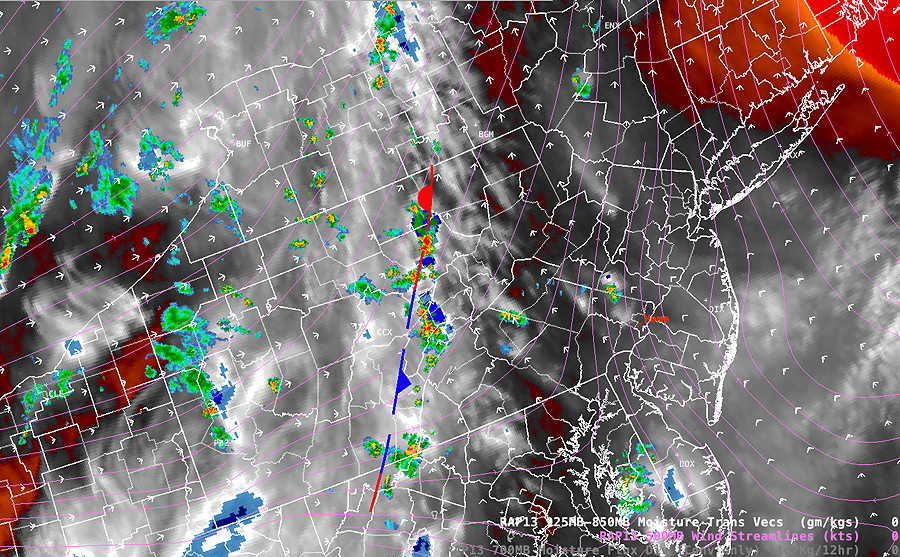
Current WV image with radar and RAP jet stream level wind streamlines superimposed. A weak dissolving front is in central PA. For Friday, this weak frontal remnant will be a focus of greater coverage of thunderstorms late Friday afternoon and evening, mostly in far northwestern suburbs, . (Click on image for a larger view.)
Some fog is possible Friday morning.
The weak frontal remnant will be a focus of greater coverage of thunderstorms late Friday afternoon and evening, mostly in far northwestern suburbs. It’s unclear how far the storms will travel eastward into the Philadelphia area late tomorrow, but several models have them falling apart. The ECMWF and HRDPS has some heavy rain that makes it into the immediate suburbs.
I’ll need to update tomorrow morning.
Thursday’s Weather
Updated Thu 07/06 @ 8:33 AM — Expect similar widely scattered thunderstorms to pop up again today, somewhat more westward than yesterday’s showers. The models are relatively consistent with the placement of these thundershowers. They can occur any time between 2 PM and 9 PM today, most likely time frame is 4-7 PM.
HREF forecast placement of today’s thundershowers—
Today’s HREF forecast location of pop up showers. As always, these locations should not be taken literally. Basically expect any showers that pop up to be near and west of the Delaware river. The ECMWF, not shown, has the majority of showers a little further southward. (Click on image for a larger view.)
Upcoming Weather Thur-Sun
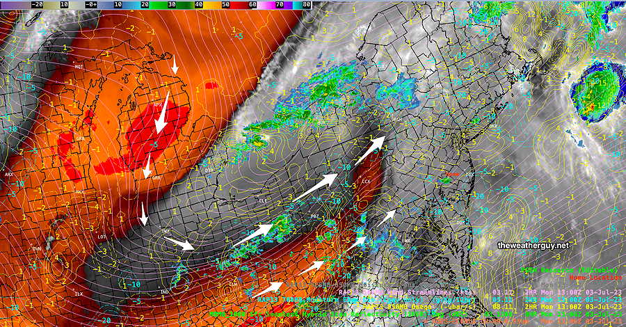
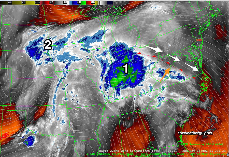
Updated Wed 07/05 @ 7:59 PM —Satellite Water Vapor images can provide the visual clues into model forecasts, and of course, the models incorporate upper air data from these images for their forecasts.
The current pattern of scattered afternoon thunderstorms is being driven in part by a small upper air cyclonic trough (1 below) over Pennsylvania. More info in the caption below—
Water Vapor at 7:46 PM with superimposed RAP jet stream level wind stream lines. (1) The upper level weak trough (white arrows) is adding some lift for thunderstorms today and for Thursday. (2) An approaching weak cold front will move through on Friday with more significant rainfall. (3) A developing large trough descending down from Canada will interact with disturbances (4) late Saturday and especially Sunday. Possibly heavy rain possible on Sunday. (Click on image for a larger view.)
Widely scattered thunderstorms expected again Thursday afternoon and early evening. These will mostly be in the western suburbs of Philadelphia, possibly extending into the city. More widespread showers and thunderstorms likely later Friday. Heavy rain possible Sunday.
Wednesday Weather
Updated Wed 07/05 @ 11:29 AM — High humidity and some weak upper air disturbances will cause scattered thunderstorms to develop any time from 2 PM through about 8 PM. Low vertical shear will cause any pop up storms to collapse under their own downdrafts.
The latest HREF shows most of the possible thunderstorms will be in NJ. This also supported by the ECMWF. The NAM-NEST is showing areas of high CIN (convective inhibition), so we’ll see if these actually form—
Today’s 12z HREF ensemble model shows most of the activity in NJ. (We’ve seen from recent days that the models aren’t able to exactly forecast the exact location of storm development in this scenario. (Click on image for a larger view.)
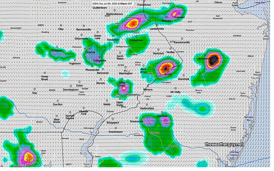
Update Tue 07/04 @ 4:56 PM— A quick update. Strong storms moved through eastern Bucks county this afternoon and blossomed as they moved across into NJ.
At 4:41, large cluster of strong thunderstorms with likely hail was moving across central NJ—
None of the models predicted this cluster.
Tuesday- 4th of July- Weather Update
Update Tue 07/04 @ 8:54 AM— Predicting the exact location of the storms over the past few days hasn’t been easy, nor is it ever; the model forecasts can be extraordinary, but they’re models of reality, not reality.
Today, Monday, we have an assortment of high severity factors that may lead to strong storms, but knowing where they’ll pop up is like trying to predict where the first bubble will form in a heated saucepan. The general model consensus is that they’ll be scattered, rather than organized.
The current HRDPS is slightly more aggressive with storms than the latest HRRR, but it gives the general location of where these pop up storms will develop—
0z HRDPS precipitation rate at 2 PM.
The timing of the storms can be anytime between 2 PM and 8 PM. The general trend from the HRRR and NAM-NEST is that the immediate Philadelphia area will be a likely place for these storms to develop.
HRRR Severity Parameter
Sept 1 , 2021 Tornado Outbreak (example of highly severe)
Recent April 1st 2023 Tornadoes (Example of severe)
Severity Parameters Impact: ⚑ indicates favors Severity ⚐ indicates Possible Severity ↓ indicates works against Severity ⇩ Significant, but less impact
It should be noted the last night’s HIRESW-FV3 did an incredible job with last night’s storm placement. The latest HIRESW-FV3 is forecasting very isolated thunderstorm development today.
Monday Update
Updated Mon 07/03 @ 3:13 PM — The 14z HRRR model has little in the way of thunderstorm activity in Philadelphia this afternoon and evening.
Here’s the HRRR—
14z HRRR shows the immediate PHL area free of showers/thunderstorms through 4 AM. (Click on image for a larger view.)
Monday Forecast Update
Updated Mon 07/03 @ 11:44 AM — This morning’s models again has the majority of today’s thunderstorms moving through to our far north and south. The immediate Philadelphia area doesn’t appear to be in area of main activity.
Today’s 12z HRRR precipitation rate at 7 PM—
12z HRRR shows much of the activity to our north and south at 7 PM.
The high resolution statistical model (HREF) shows most precip today missing the immediate PHL area—
12z HREF total precip through 10 PM Monday. (Click on image for a larger view.)
Previously Posted Mon 9:29 AM —
Monday Forecast
A slowly moving upper trough with areas of vorticity rotating into our area will provide warm/hot, humid conditions and the ongoing possibility of thunderstorms today.
The upper air scenario, as depicted by a satellite water vapor image, shows the trough —
Water Vapor image with superimposed RAP 250 mb wind flow, White arrows capture the upper flow. Numerous small scale disturbances will be rotating into our area today and gain on Tuesday. (Click on image for a larger view.)
Highest chance of thunderstorms over the immediate Philadelphia area will be between 5 and 10 PM, but scattered storms can be expected any time. High temperatures 88º Blue Bell and 91º Philadelphia.
Update Sun 7/02 11:05 PM — A quick late update. Tonight’s NAM-NEST and HRRR have some thunderstorms moving through Philadelphia about 1-2 AM. This is a change from earlier models.
Additionally, storms expected Monday afternoon and evening. Another change — Tuesday may also have storms, as the cold front hangs up near here. Updates tomorrow.
Thunderstorm Update
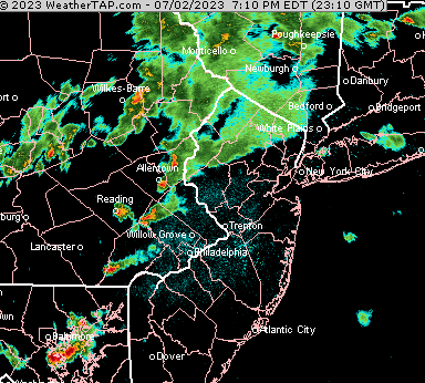
Updated Sun 07/02 @ 7:42 PM — The TV meteorologists are doing a fine job this evening covering the severe weather outbreak in far western suburbs. Here’s a recent radar with the few severe storms that have developed—
Radar Loop ending 7:22 PM courtesy of WeatherTAP.com (Click on image for a larger view.)
As has been the case both last night and again this afternoon, the models do not have the storms above coalescing into a line that will enter Philadelphia.
On the contrary, the HRRR model runs, supported by the Canadian models, have forecast that these storms will move to our north and to our south this evening, largely missing the immediate Philadelphia area.
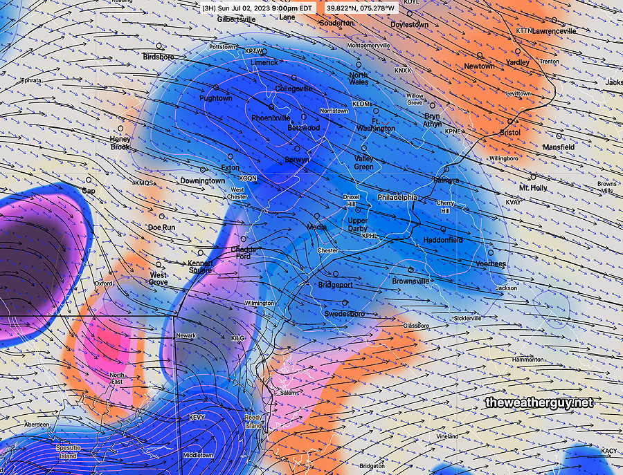
The reason for the storms not entering Philadelphia— a strong area of negative vorticity (sinking motion) will be over Philadelphia, dampening out the storms—
HRRR 9 PM forecast : A large area of negative vorticity (blue shading) at the jet stream level will dampen out any thunderstorms moving into Philadelphia. (Click on image for a larger view.)
We never know in advance if the models are correct about exact placement of severe weather, but that’s the current model forecast. And I imagine that’s why you visit this blog.
Live Thunderstorm Blog 07-02-23
Sunday Thunderstorm Outlook
Updated Sun 07/02 @ 9:26 AM — As forecast last night, the heavy showers and thunderstorms last night stayed far northwest of the city, with most areas in the Delaware Valley getting 0-0.02″ of sprinkles.
Last night’s early models had today’s potential storms strangely bypassing the immediate Philadelphia area, but the 06z models now show Philadelphia in the path of some strong storms today.
The latest HRRR and RAP model runs have just become available (12z runs) and show thunderstorms developing in place and moving in between 4:30 PM and 8 PM. Peak is 6-7 PM.
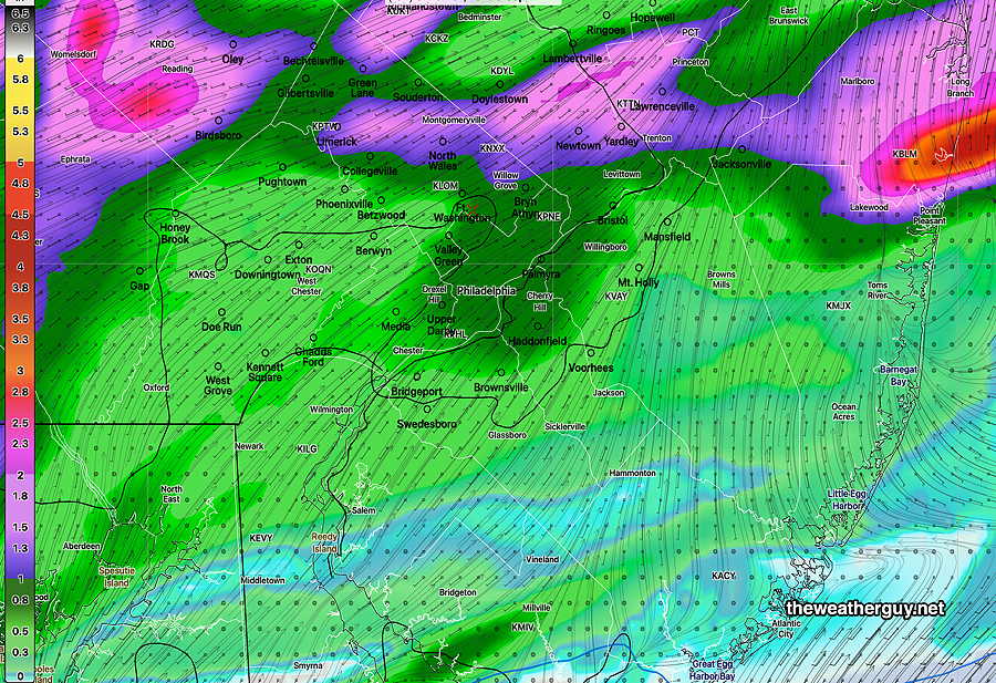
Despite very high “precipitable water” (PWAT ) of over 2 inches, the models are placing heavy rain accumulation north of the city. Here’s the forecast total precipitation, which is low considering the PWAT, suggesting that the storms won’t linger—
Canadian HRDPS total precipitation from the storms Sunday evening (Click on image for a larger view.)
Comparing today’s forecast severity parameters to recent severe events, the potential severe storms with damaging winds today is high—
Today’s HRRR Forecast Severity Table—
⇣
Sept 1 , 2021 Tornado Outbreak (example of highly severe)
Recent April 1st 2023 Tornadoes (Example of severe)
Today’s 12z HRRR Forecast
Today’s Impact
Today‘s Notes
CAPE Joules/kg
3500-4200
2100
2500-3204
⚑⚑
Helicity m^2/s^2 (tornados)
1350
655
208 (420)
↔ ⚐
High southern Chester County
Vertical Shear 1/sec
40-46
40-45
18
↓ ↓
Precipitable Water
2.7″
0.83”
2.1″
⚑⚑
Lifted Index º K
minus 6º
minus 9.3º
minus 6.2º
⚐
average
HRRR Hail inches
1.9
1.4
1.6
⚑⚑
Thunderstorm Echo Tops
46,000 ft
32,000 ft
45,000 ft
⚑⚑
very high
Peak Wind Gusts mph
40-50
40-50
55
⚑⚑
Storm Motion Shear Vector Alignment
Aligned – ~ 90º
Almost aligned
aligned-curved direction
⚑
250 mb Jet Stream Wind mph
63
135
46
↓
Severity Parameters Impact: ⚑ indicates favors Severity ⚐ indicates Possible Severity ↓ indicates works against Severity ⇩ Significant, but less impact
Sunday Update
Updated Sat 7/01 10:40 PM — With the backdrop of having had a cluster of storms move through Cape May County this morning, unpredicted by any model, I’m going to attempt to forecast the showers and storms expected on Sunday.
A warm front will move through the area tonight into Sunday morning with showers and thunderstorms. Most likely time is from 2 AM to 5 AM. The models are keeping the storms mostly far northwest of the city, although some may make it in here.
Sunday morning will start cloudy, but sunshine should break through high thin clouds by noon.
The warm front hangs near us on Sunday. High moisture and instability will cause more storms to develop late afternoon and evening, with increased chances between 4 PM – 10 PM. Strangely, tonight’s models have most of the activity moving northwest and south of the city, somewhat missing the immediate Philadelphia area.
It’s always difficult to know if the model placement of the storms will be accurate.
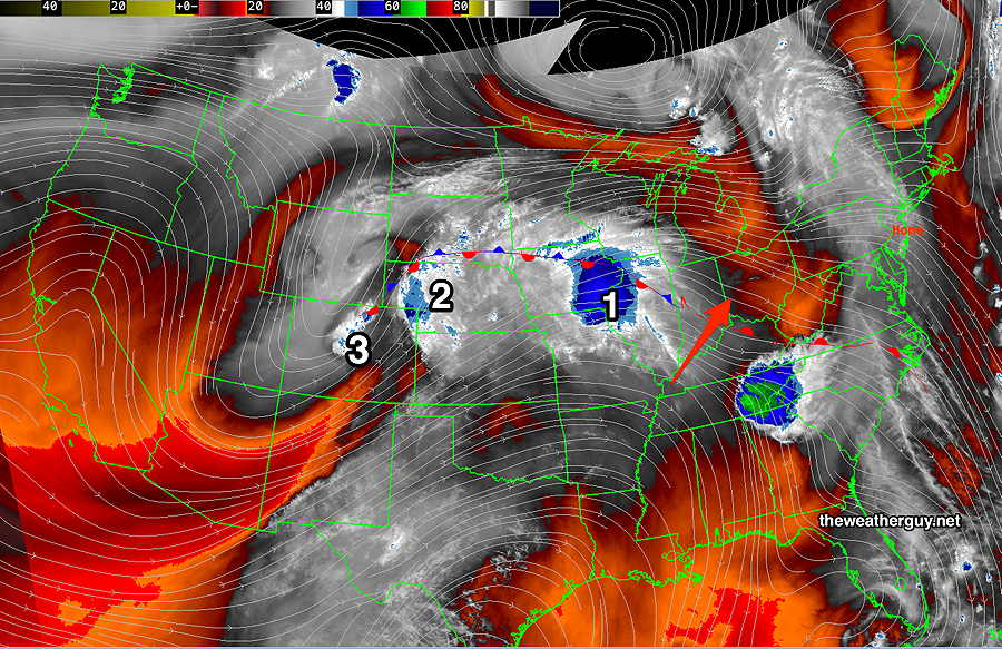
Updated Sat 07/01 @ 9:25 AM — According to models, the clouds over us this morning should dissipate by noon. The slowly approaching warm front seems to be moving a bit faster than forecast yesterday. Some thunderstorm activity expected moving into Philadelphia as early as 8 PM this evening (HRDPS) but the latest HRRR keeps it moving in until after midnight.
This morning’s water vapor image with superimposed RAP model jet stream level wind streamlines. I’ve drawn the warm front in —
Water Vapor at 9:09 AM today with RAP model wind streamlines at jet stream level. (and white arrows)/ The disturbance (1) will affect us later Saturday into Sunday as areas of vorticity shear off into the flow ahead and behind the warm front. The disturbance (2) will affect us on Monday. (Click on image for a larger view.)
A stationary boundary running generally west-east to our south will move north as a warm front Saturday night into Sunday morning. The exact timing varies from model to model, but somewhere between daybreak and noon on Sunday is the general trend, although some models have it hanging up in our area. —
Satellite Water Vapor image on Friday shows several disturbances (1,2,3) along a frontal boundary. This frontal boundary will move north as a warm front on Saturday night with showers and thunderstorms later Saturday night into at least Sunday morning. It’s unclear if the warm front will move far enough north to have the showers end Sunday afternoon. (Click on image for a larger view.)
Before the warm front, showers develop, but all the models keep the showers and thunderstorms from moving eastward during the daytime on Saturday . Western Chester county and areas west may see some showers and thunderstorms Saturday evening.
Saturday
Partly to mostly sunny through mostly high clouds most of the day but a few hours of cloudiness possible early afternoon in some locations. Becoming windy during the afternoon.
High temperature 85 – 86º ( NBM model— location Blue Bell, PA )
Showers and thunderstorms develop near Philadelphia after midnight Saturday into Sunday morning.
Sunday
Showers and some thunderstorms before daybreak and into the morning, depending upon the movement of the warm front. Some models have the warm front stalling near us. The NAM-NEST has the warm front stalling with a line of thunderstorms, possibly strong, moving through midafternoon.
The latest NBM has showers and thunderstorms in the afternoon as well, so there’s higher than usual uncertainty with the Sunday forecast.
High temperature 83 -85 º ( NBM model— location Blue Bell, PA)
A cold front comes through later Monday with showers and thunderstorms.
Sun 5:24 PM Forecast Review —The earlier storms today discussed this morning all developed in New Jersey, but additional storms sprung up (and continue to spring up) throughout the area.
As a followup to the discussion earlier, here’s the earliest signs of the storm development at 10:21 AM today—
Early signs of development in NJ. (Click on image for a larger view.)
At 10:22 AM, storms developing in NJ—
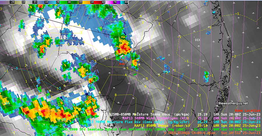
Water Vapor with superimposed radar and RAP Vertical Velocity Pressure (yellow contours) Notice the immediate Philadelphia area is in a region where there was no vertical velocity pressure at the time. Despite the upper air disturbance moving through, no storms develop at this point. (Click on image for a larger view.)
At 1:06 PM, the storms are still over NJ, but storms are popping up in Chester county. The RAP model shows positive Vertical Velocity Pressure in Chester county.
Vertical Velocity Pressure (also called Omega) aid the development of the storms in Chester County (Click on image for a larger view.)
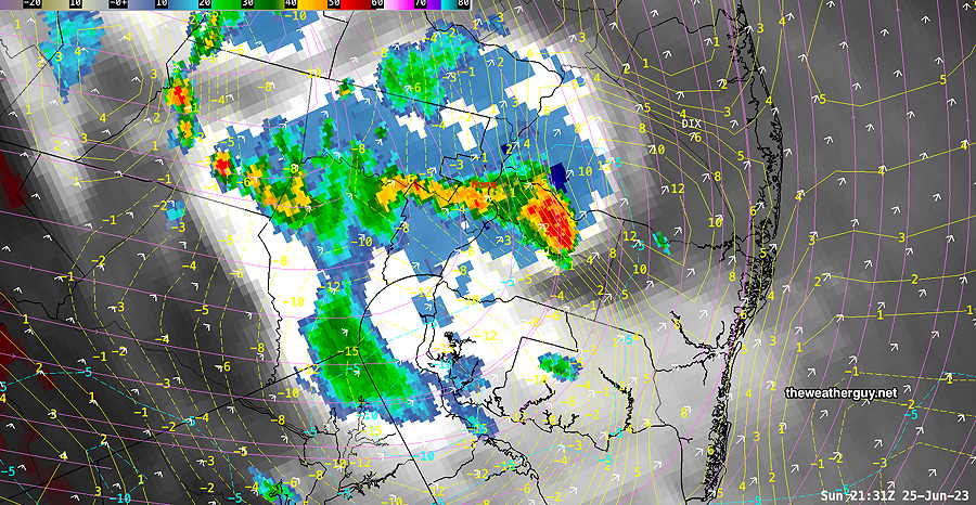
At 3:52 PM—
Large stationary complex over Abington and NE Philadelphia likely caused flooding in this region.
At 5:40 PM, active storms still developing as I type this, but the storms in the immediate Philadelphia area are moving into an area of negative Vertical Velocity Pressure and should diminish in intensity. The storms in NJ are poised for intensification—
Sunday Forecast Update
Updated Sun 06/25 @ 9:03 AM — The HRDPS and latest RAP model have thunderstorms forming dynamically about noontime today. Most of the other models are forecasting storms developing around 2-6 PM.
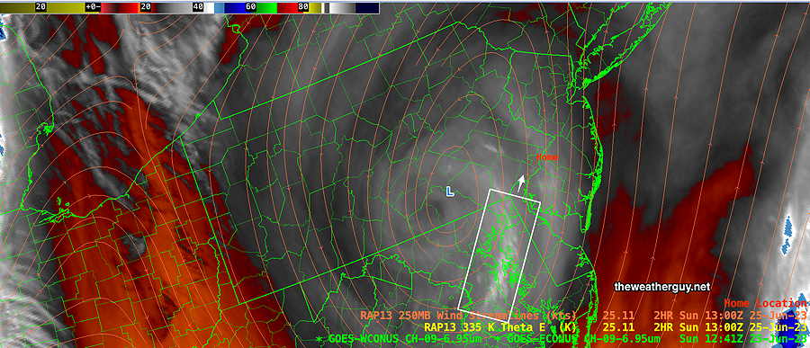
So which forecast, if any, can we hang our hat on? The first clue is to look at the current conditions, specifically the current satellite water vapor image (Channel 9). Is there any disturbance visible that will move in about 3 to 4 hours?
Current Water Vapor image (channel 9) at 8:41 AM. The white box outlines a area of colder moisture (whiter) than surrounding areas. Water Satellite Water Vapor images are different than visible cloud images. Water Vapor images show the temperature of emitted infrared radiation, instead of the reflected light from clouds in visible satellite imagery. In this image, whiter and in some cases blue areas, show the highest and therefore coldest “effective level” of the water vapor layer. Colder effective layers are indicative of rising motion. (Click on image for a larger view.)
In the above image, we see an area of colder (whiter) effective layer, suggestive of the spark for thunderstorm development. This area is right over Chesapeake Bay, about 2-4 hours away by jet stream winds, currently at 30 mph in this region. (The one thing not in favor of this forecast: the upper air area is not as developed as it might be. The blue areas in the lower right corner are examples of much more developed upper air disturbances.)
To look at current water vapor images (channel 9) check out this link.
So the noontime to1 PM forecast may be correct. Let’s see. This is the fun of weather forecasting.
Sunday Forecast Update
Updated Sat 06/24 @ 10:53 PM — We had the majority of the rain late morning and early afternoon. The forecast for a 3-5 PM peak in thunderstorm activity didn’t occur around Philadelphia, despite almost every model having predicted it. The NBM thunderstorm prediction was all wrong.
If we go with today’s relative ‘winner’ in the forecast timing of the today’s showers, it would be the HRDPS. So let’s go with it for Sunday.
The latest HRDPS shows showers beginning to pop up around noon Sunday with a relative peak between 1 PM and 4 PM. The showers will be scattered and like today, there will be periods of sunshine interspersed. It will be much warmer Sunday with highs around 85º but with a larger than usual uncertainty of about ± 3º.
Here’s the HRDPS forecast for 2 PM Sunday—
Today’s 18z HRDPS forecast for 2 PM Sunday. Scattered showers and thunderstorms develop. The exact location can’t be inferred from the models. (Click on image for a larger view.)
Saturday Forecast Update
Updated Sat 06/24 @ 10:55 AM — It’s pretty clear, based on current radar and this morning’s models, that showers and thundershowers are forming now (late morning) and more numerous showers and storms are expected over the next few hours.
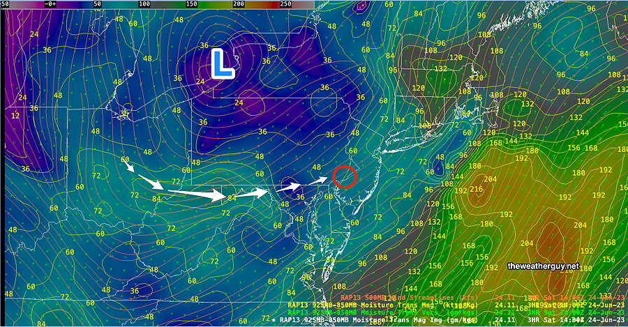
Updated Sat 06/24 @ 8:40 AM —The main area of rain from last night has departed to our northeast. Another area of enhanced moisture is in West Virginia and will rotate into our area this afternoon. Combined with the cyclonic flow and some breaks of sun, thunderstorms are expected to form this afternoon.
RAP model moisture transport shows an area of enhanced moisture in West Virginia that will rotate up into our area this afternoon. Jc (Click on image for a larger view.)
Rainfall will not be as heavy as it was in some areas yesterday. (PWATS yesterday were in the 2.0-2.1″ range) Today’s PWATs will be closer to 1.6″
While we’ve seen it’s impossible to predict exact timing and placement of the rain, it appears that showers and thundershowers begin popping up about 2-4 PM today as the area of enhanced moisture moves in, based on the HREF. The Canadian HRDPS has some showers popping up earlier, just before noontime.
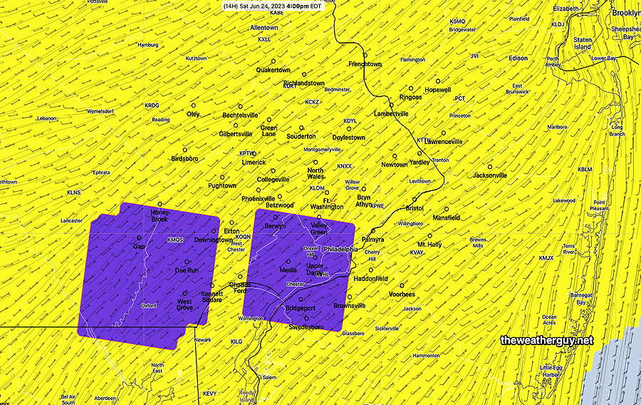
The NBM 4.1 model has a new parameter, thunderstorm coverage, which attempts to predict the areas/timing of greatest thunderstorm density. It pegs the period 3-5 PM as most active with the greatest areal coverage of thunderstorm activity as shown below—
06z NBM forecast Thunderstorm Coverage- Yellow = scattered thunderstormsDeep Purple = areas moderate thunderstorm coverage; areas where the greatest number of thunderstorm cells will be at 4 PM. (Click on image for a larger view.)
Update Fri 6/23 11:39 PM — Additional high resolution models just available have showers and thunderstorms during the early afternoon as well as into the evening..
Update Fri 06/23 @ 9:59 PM — Tonight’s HRRR just available has considerable sunshine with clouds for us mid day and afternoon. Showers don’t move in until after 6 PM Saturday.
Previously Posted Fri 9:09 PM —
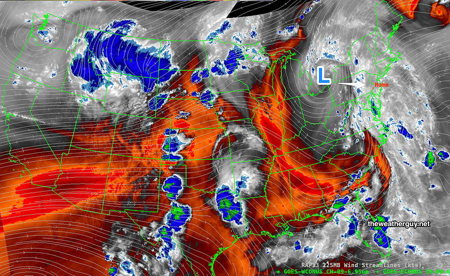
The closed upper low pressure system will move closer to us on Saturday through Sunday. As you can see from the water vapor image below, the ‘action’ with an upper low is often a certain radius away from its center; as it moves eastward over Pennsylvania on Saturday, we’ll still be in an unstable air mass, but much of the active moisture plume will move to our east. Nonetheless, instability will lead to scattered thunderstorm development.
Water Vapor image 8 PM Friday show the upper low over Lake Erie. This low will move SSE towards central PA over the weekend. Much of the extreme moisture plume currently over us will move away from us. but instability will still result in showers. (Click on image for a larger view.)
Saturday
Cloudy and damp early. Breaks of sunshine expected during the day, interspersed with showers and thunderstorms— Showers and thunderstorms most likely during the mid to late afternoon. Look for updates for the timing of showers. Very humid with dew points in the low 70s.
High temperature 80.8º sd 2.5º ( NBM model— location Blue Bell, PA)
Sunday
Periods of sun and clouds. More cloudiness in the afternoon with a good chance of scattered showers and thunderstorms, especially after 2 PM and into early evening. High probability far northwest of the city. Still humid with dew points 68-70º.
High temperature 84.7º sd 2.6º ( NBM model— location Blue Bell, PA)