#Philadelphia #weather #PAwx
Final Update on this Storm
Posted Sun 01/21/24 @ 3:13 PM—
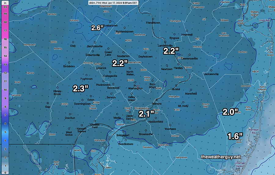
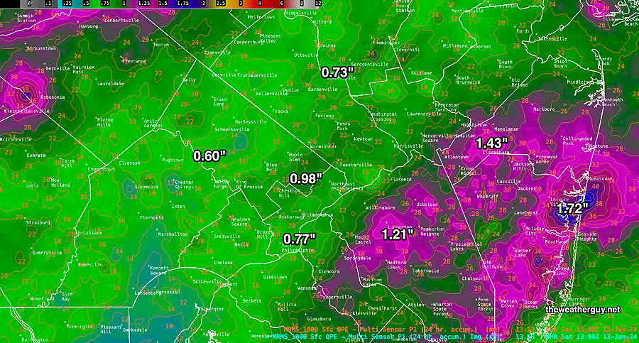
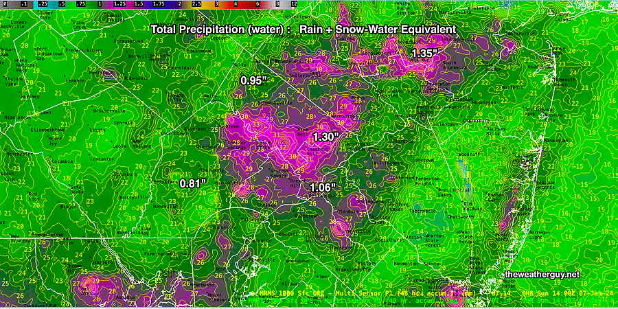
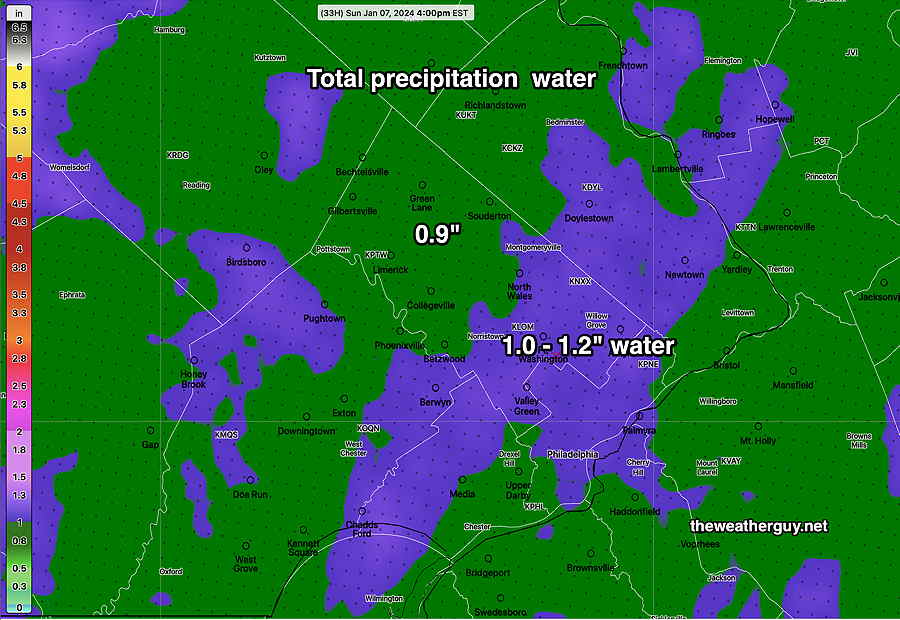
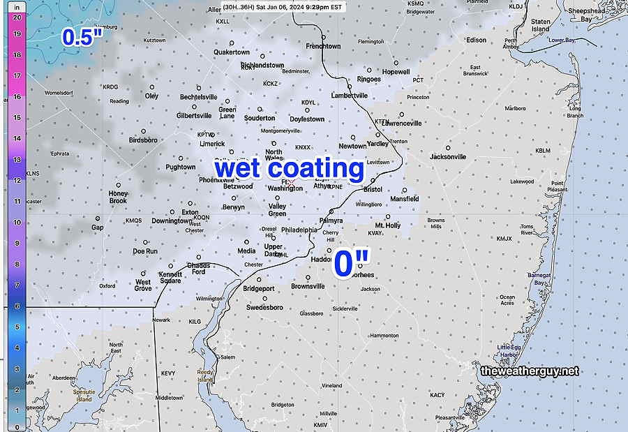
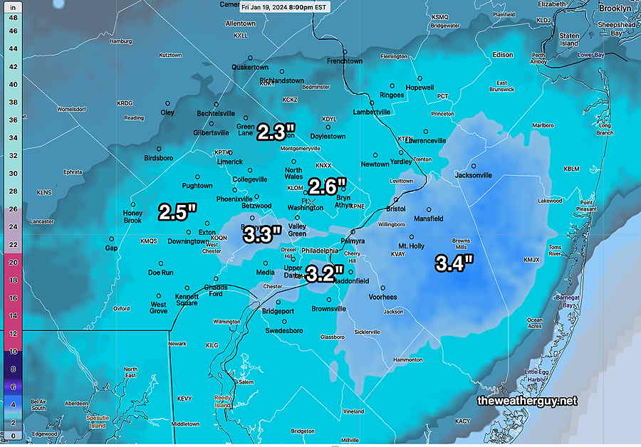
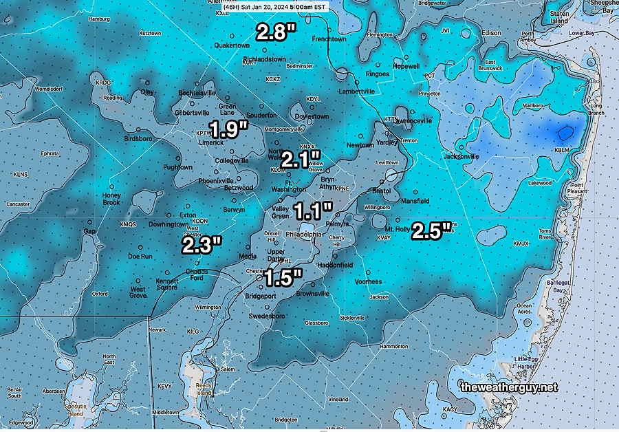
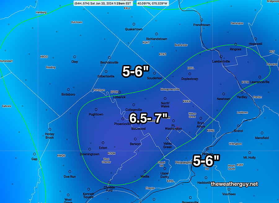
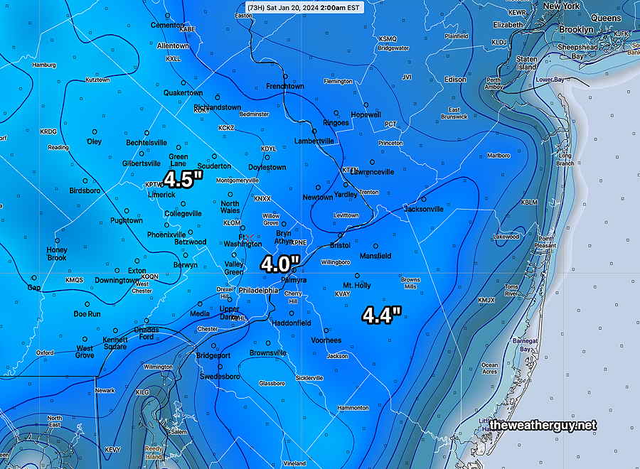
My first inclination was that the snow water ratio was higher than expected. But I decided to look at the actual water values that fell. Here’s the MRMS liquid water totals for the storm —
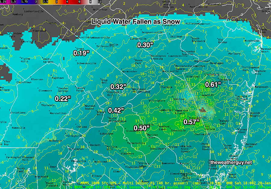
In most areas the actual water that fell as snow was at least 0.1 – 0.4 inches higher than the models had forecast. Even at a snow-liquid ratio of 11, the snow totals forecast were going to be at 1.5 to over 4 inches too low.
Many models had forecast as little as 0.23″ water (GFS ECMWF) and 0.30″ water (NAM, NBM). Since all model snow forecasts start with the actual water expected to fall, the model snow accumuation forecast was destined to come up short.
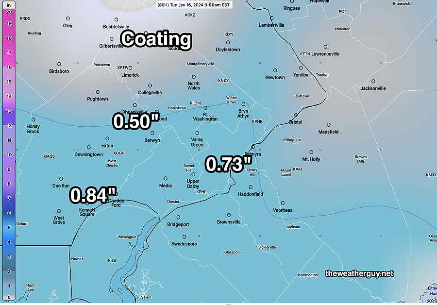
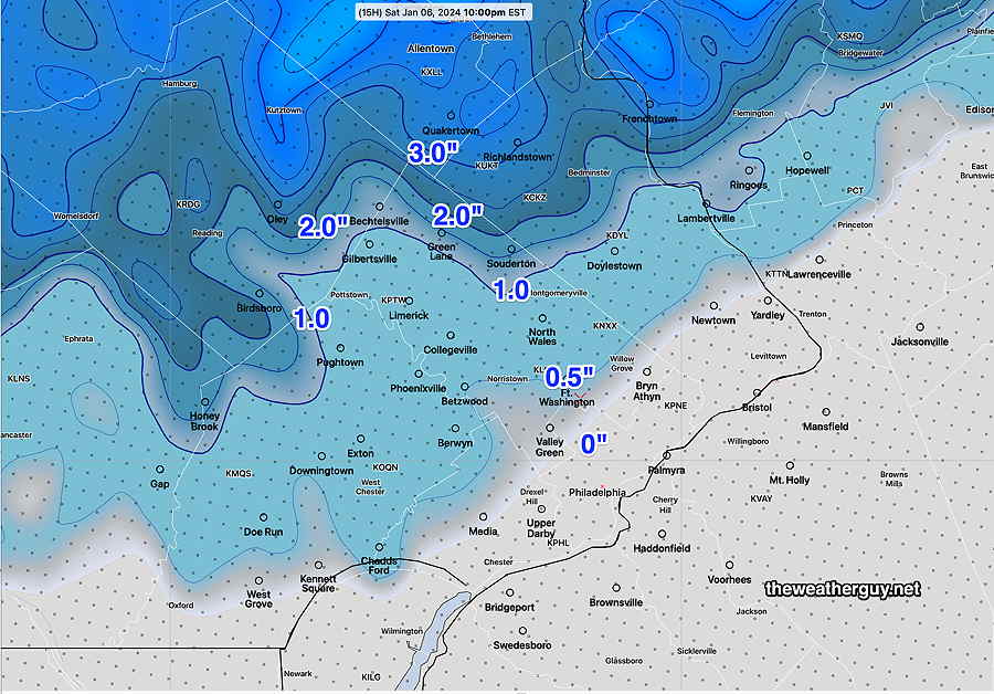
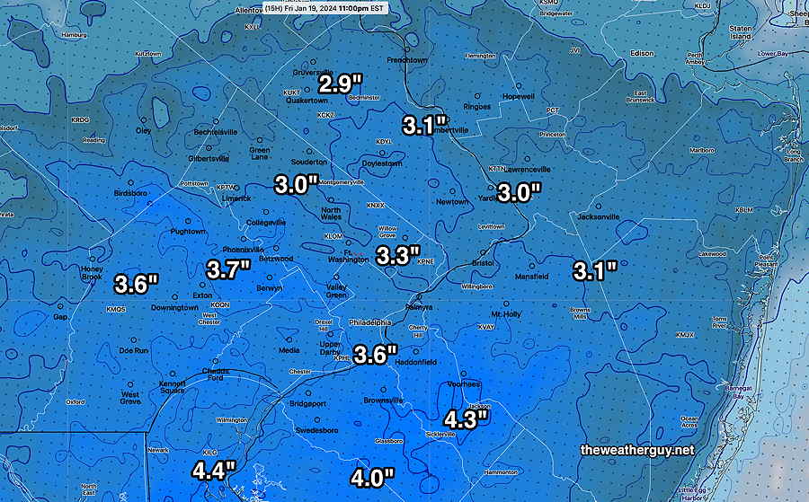
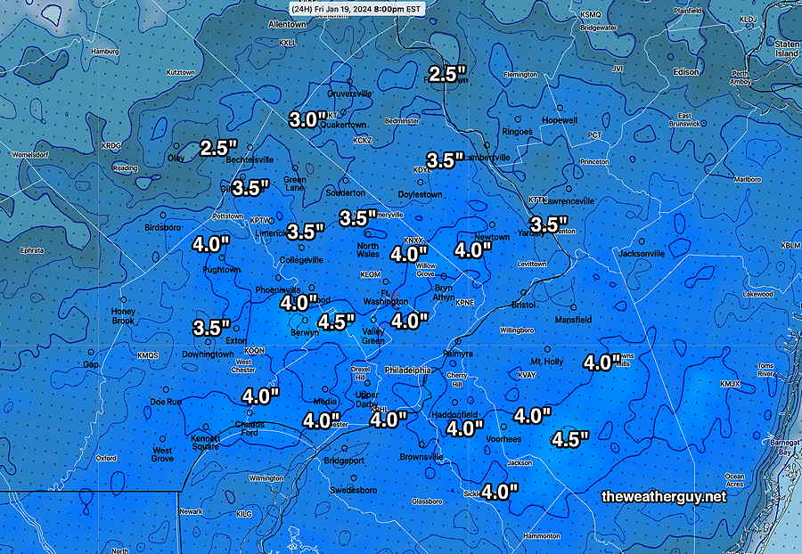
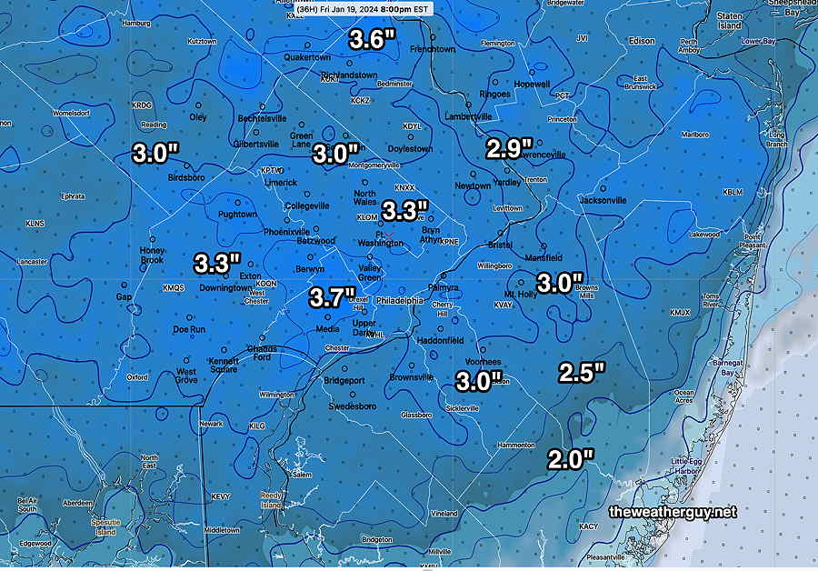
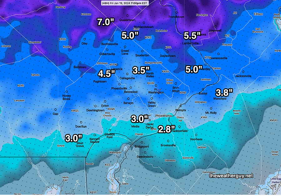
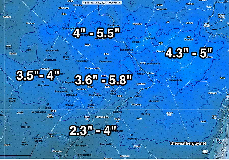
Posted Friday 01/19/24 @ 2:57 PM — The snow is beginning to taper off around here and I’ll be getting out the snow shovel when it ends about 4 PM to 7 PM.
In my neck of the woods, we’ve had 4.5″ of snow so far at 2:55 PM and my guess is that the totals in the immediate PHL area will be in the 4-5″ range with higher amounts close to 6″ south into southern Delaware County and South Jersey.
I think the NWS did a fine job with their forecast of 3-6″and my forecast of 3.3″ or so underestimated the snowfall. Influenced by the lower totals predicted by the GFS and Canadian CMC- HRPS, I ended up “ignoring the NAM”.
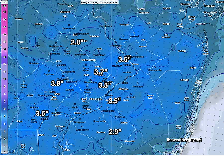
That said, I still would have come in low on the snow totals had I used the NAM precip amounts. The snow:water ratio that generally works here is 10:1 or 11:1. Because of the cold temperatures, the snow:water ratio during this storm was 15:1, 16:1 and higher.
I did not know that the NBM has a new parameter, SNOWLR (snow-liquid ratio). I’ve always wanted that number for forecasts, and the next storm, I’ll use it.
This was the SNOWLR at noon today, as calculated by the NBM—
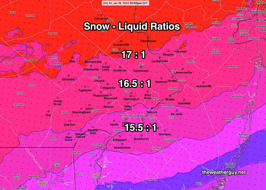
With the ratio as high as it was, the snowfall was about 50% more than I had (and would have) forecast, even if I had used the NAM.
Friday Snow Update
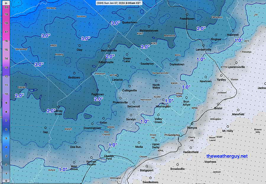
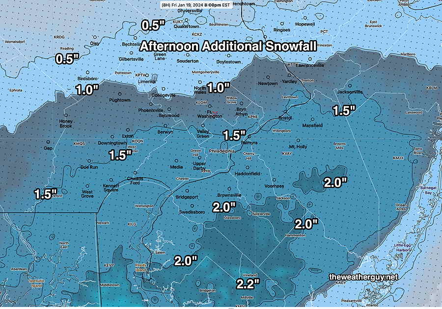
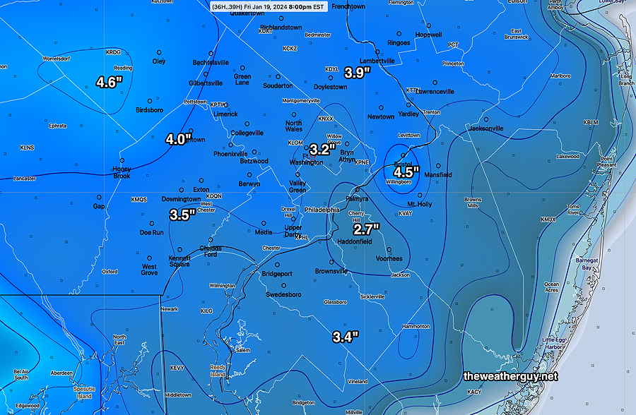
Posted Friday 01/19/24 @ 12:42 PM — It appears that we will have an additional 1-2 inches of snow from noon to about 4-7 PM when it tapers off and ends.
Additional snow forecast from noon onward—
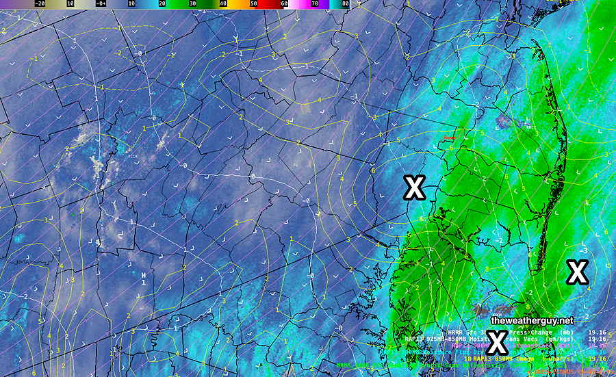
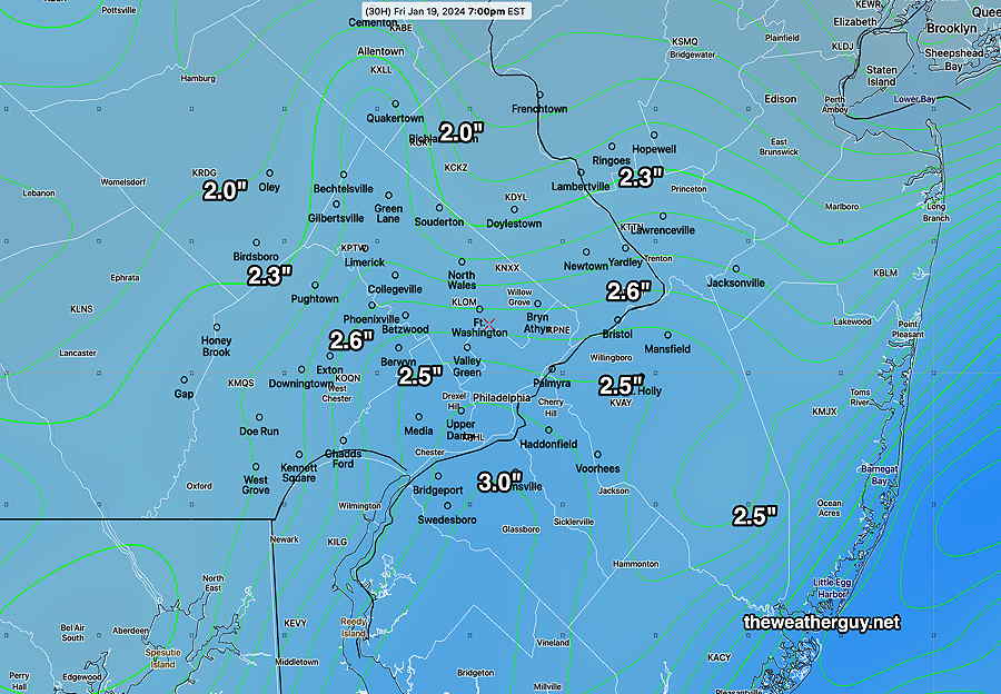
Posted Friday 01/19/24 @ 12:30 PM — I wish I could take back that last blog entry below. What looked like an area of precipitation moving off to the east was actually not moving at much at all. In fact, in the short term, it’s blossoming.
A persistent area of vertical motion (called Omega) has developed right over our area and South Jersey which will keep the snow falling into the early afternoon. We already have 3.25″ of snow in our neck of the woods.
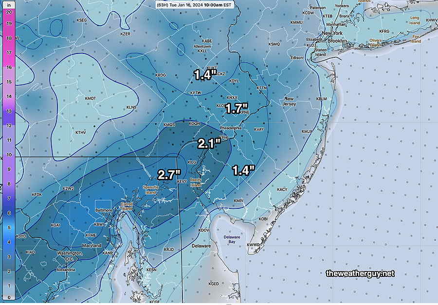
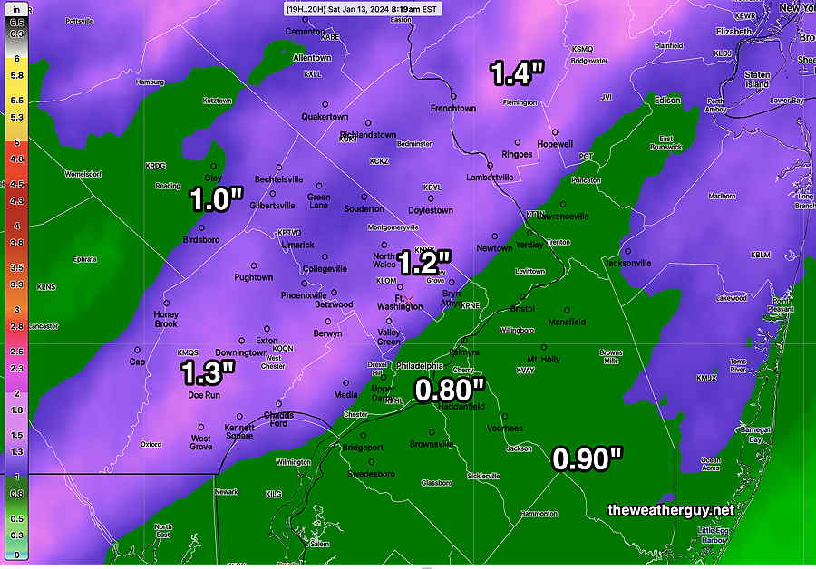
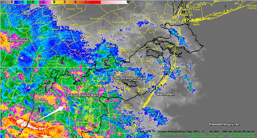
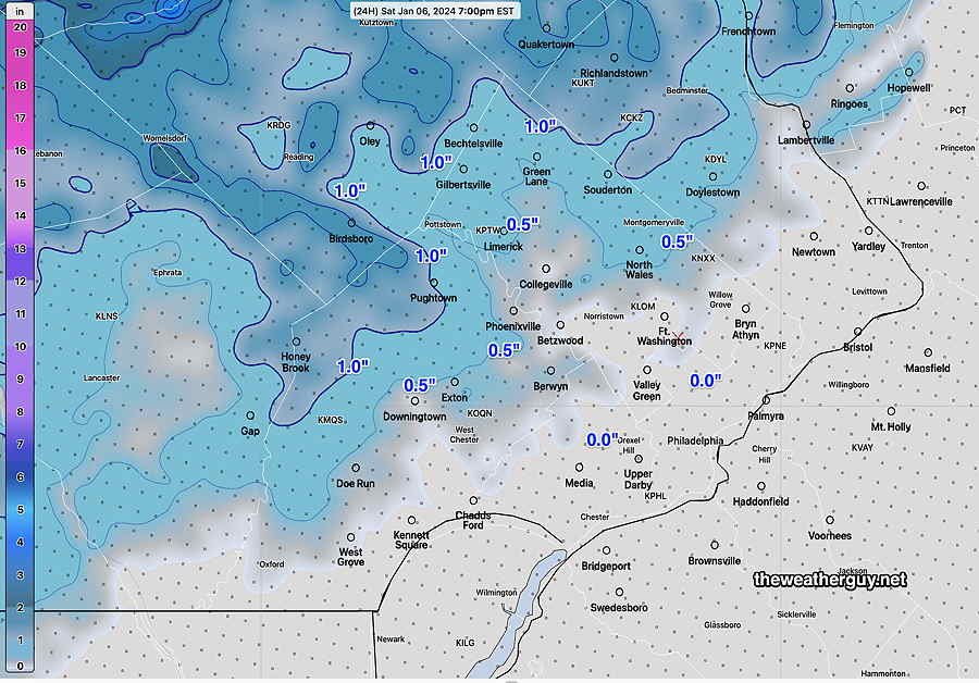
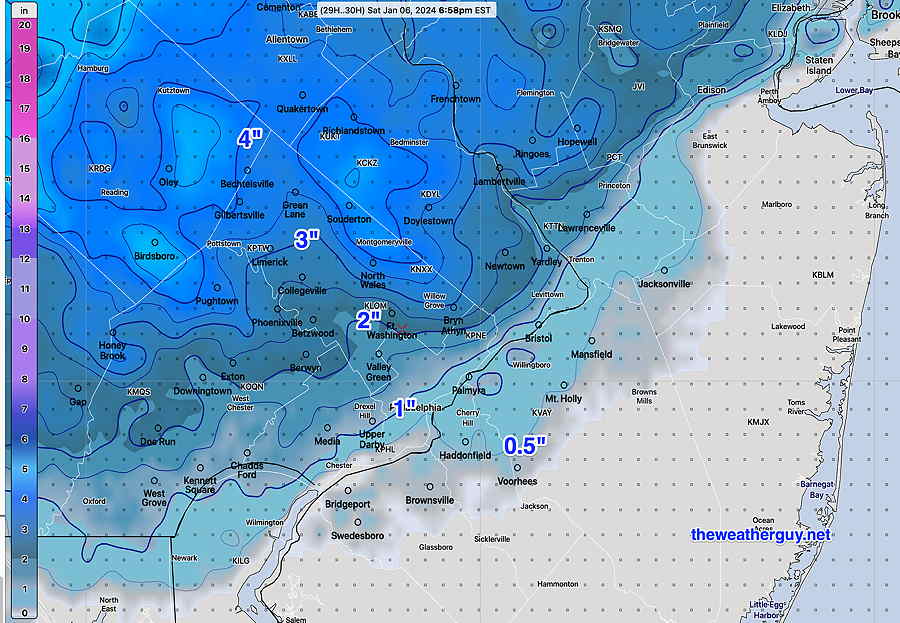
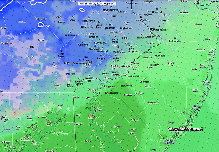
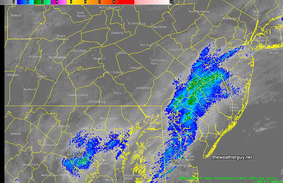
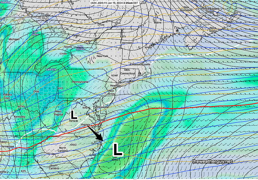
Posted Friday 01/19/24 @ 11:01 AM — I think we’re beginning to see why the Canadian models (and the GFS) were so light on the snowfall forecasts. The band of heavy snow is ready to exit our area, as shown by the latest MRMS—
Friday Snow Update
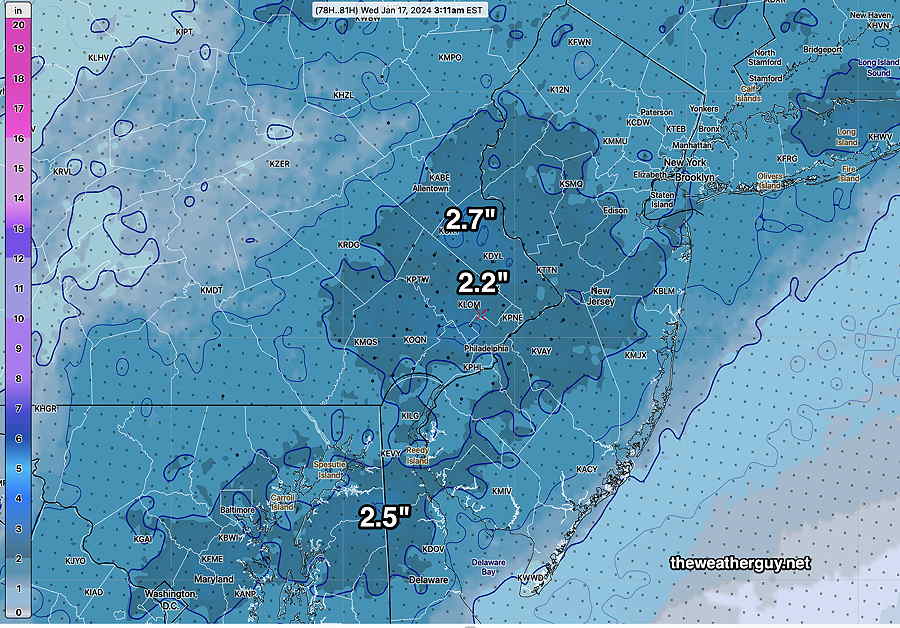
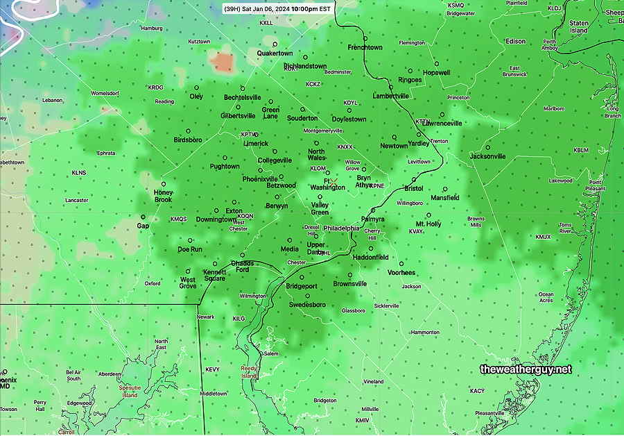
Posted Friday 01/19/24 @ 9:41 AM — The latest 01z NBM available shows a general 3-4″ snowfall in our area. 4-6″ are possible in South Jersey and Delaware. Here’s the NBM forecast for additional accumulated snowfall (meaning, add what you already had at your location at 8 AM.)
The snowfall totals are still predicted high because this is and will be a very light weight snowfall where the snow-water ratio is closer to 15:1 instead of the usual 10 or 11:1.
Posted Friday 01/19/24 @ 7:32 AM — A fast look at some models show a total snowfall of 2.0-3.5 inches for our region, the lesser amounts north of Philadelphia and there may be somewhat higher amounts in south Jersey. Our NOAA based models cluster around 3.0-3.3 inches. The Canadian high resolution has been consistent in the low end of the spectrum, around 2 inches in the immediate PHL area.
I’ll post some new graphics before 10 AM this morning.
Snow Forecast Update
Posted Thursday 01/18/24 @ 9:46 PM — The latest ECMWF, German ICON, and Canadian models ( all from this afternoon) are still in the 2 inch to 3 inch snowfall range and our higher resolution models are in the 3-4 inch range. Tonight’s NAM and NAM-NEST have moved those 4 inch values to southern Chester counties, with lesser amounts in the north.
I’m going with the NBM model snow forecast below. The latest available (01z) is shown below. With the global models so much different, it would not surprise me if this NBM is in the high range and we get less —
Light snow flurries are around the area tonight. The snow starts about daybreak and it will be light in the morning. Heaviest snow will be towards noon and early afternoon. It tapers to flurries about 4-6 PM.
The interesting thing about snowfall predictions is that somehow we weather people think we can successfully predict, within an inch or two, how much snowfall we’ll receive in any location. The truth is that we really can’t do that, any more than we can predict within a 0.10 inch how much rain will fall in any location during a rainstorm.
Anyone looking at recent heavy rainstorms I’ve covered in this site knows that the model data I’ve posted about rainfall totals in advance of the storm never reflect exactly what happened, sometimes not even closely.
A simple comparison of my MRMS actual rainfall post-storm reviews show the predicted rainfall amounts in any one area often many tenths of an inch off, sometimes a full inch or two off. And the axis of the heavy rain banding is never exactly as the models forecast.
So when it comes to snowfall, these glaring limitations in precipitation forecasting get magnified by a factor of anywhere from 10 to 15, based on the snow to water ratio!
A mere tenth of an inch more or less of water will translate into a prediction error of anywhere from 1 to 1.5 inches of snowfall . Add to this the process of snowfall compaction and melting and it’s a miracle we do as well as we do.
Just something to keep in mind with snowfall predictions.
Forecast Change -Update
Posted Thursday 01/18/24 @ 5:25 PM — Here’s the latest GFS, which has finally come closer in line with the other models. After all is said and done, I’m leaning towards the NBM posted earlier below.
While I’m at it, I’ve been busy working on the coding to extract the median snowfall from the NBM model. (What is generally posted is the mean or average, since the NBM blends many different models.)
After too many weeks/hours of work coding, I think I’ve finally got the NBM median cumulative snowfall calculation working. And here it is—
The next models to look at will be available after 9:40 PM. If things change, I’ll update.
Posted Thursday 01/18/24 @ 4:09 PM — Sorry folks, but this has been a unusually difficult storm to forecast, where the global models, including the GFS, GEFS, ECMWF, CMC Global, have been forecasting lower snowfall while our higher resolution models are forecasting almost twice as much snowfall. So there’s a choice of the low estimate (1.5-2 inches) and the higher forecast of 3.5-4.5 inches.
The model blend (NBM) is supposed to do the heavy lifting in this situation. While it’s heavily weighted towards the HRRR, it uses over 40 models for its statistically weighted forecasts and even includes the Australian models in its latest version! That said it’s been very consistent in its own way and here’s the latest NBM forecast —
For the record, the NAM is still in the 4.5 inch range, and the latest HRRR has many 4 inch locations, especially southward in NJ. I’m waiting to see the 18z GFS available in less than 1 hour.
Posted Thursday 01/18/24 @ 1:58 PM — This morning’s models show a distinct trend downwards in the snow totals for Friday. This may disappoint many snow lovers, but the predominance of this morning’s models have only about 1.5, maybe 2.5 (3), inches of snow here, depending upon temperature and snow-water ratios. The “heavier” snowfall looks to be somewhat spotty and localized.
This morning’s models have the jet streak talked about yesterday further south than previously forecast, causing the area of heavier precip to miss our area. The slight phasing between the two systems will occur further out in the Atlantic.
I’m taking liberties in posting below the snow forecast from the still-experimental RRFS model, but I think it captures the trend well and it’s been quite consistent with its low snow forecast—
Will this change? Probably not, but check back later.
Friday’s Snow Update
Posted Thursday 01/18/24 @ 9:46 AM — The latest NBM (13z with the updated precip forecasts) shows a generally similar snowfall —
The latest NAM (below) is in a similar range. In this case, I would lean towards the NBM (above).
It will be interesting to see if the GFS, ECMWF and Canadian models come onboard with these amounts. They are forecasting much lower totals. Updates later this afternoon.
Updated Thursday 01/18/24 @ 9:12 AM — While I lean towards “Never Ignore the NAM”, this is one of those storms where there is a large discrepancy between the NAM and the GFS (and ECMWF). Looking at the precipitation totals (I’m not using the built-in snow model parameters), the NAM is in the range of a general 4.5-5″ now while the GFS and ECMWF remain in the range of 2.5-3″
It’s not clear whether this spread in snowfall amounts will remain, but in these situations, I generally split the difference. That translates into 3.5″-4.5″ or so. Reviewing the Canadian models, there’s a likelihood that the snowfall totals will only fall in the 2.5″-4″. The trend is towards lower amounts at this time.
Interestingly, this morning’s 12z NBM has that range—
A bunch of new models are coming out between 9 and 10 AM, specifically the NAM, NAM-NEST, HRRR and the updated 13z NBM. (The 01z 07z, 13z and 19z NBM model runs have major updates to precipitation forecasts.)
I’ll update later this morning.
Update on Friday’s Snowfall
Posted Wednesday 01/17/24 @ 10:11 PM — “Never Ignore the NAM” is my long standing mantra. Here’s tonight’s NAM —
Posted Wednesday 01/17/24 @ 9:30 PM — Some additional models, including some high resolution models now becoming available. Here’s the latest HRRR forecast which I think may be running a bit on the low side—
I’ll be updating tomorrow morning with the newer models.
Posted Wednesday 01/17/24 @ 5:20 PM — One more thing… the latest GFS, just available, is completely on the low end for additional snow on Friday. It’s only forecasting a generalized 2 inches of snow total for much of the area. Very different! So there’s big spread here in the forecasts.
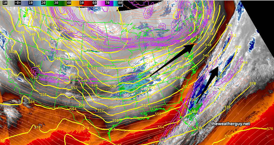
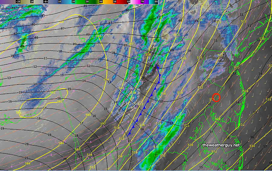
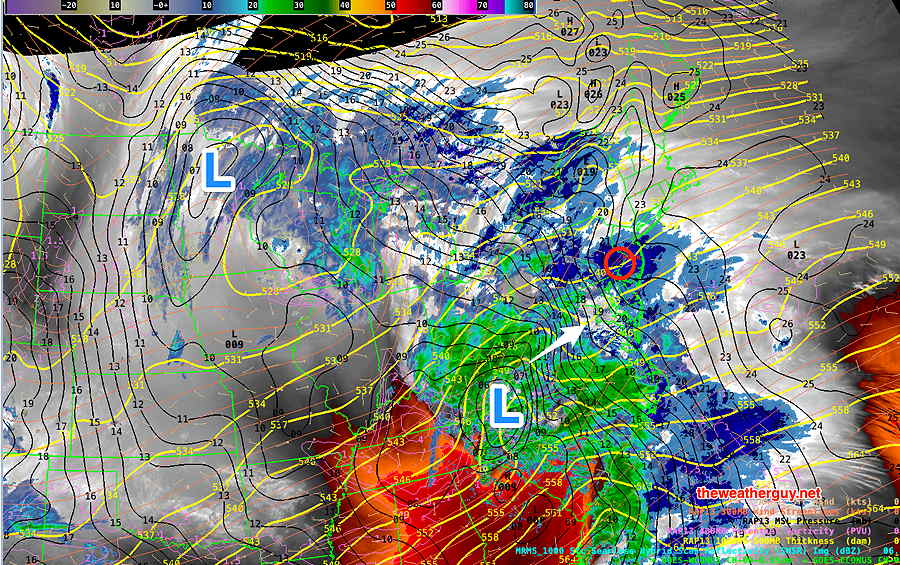
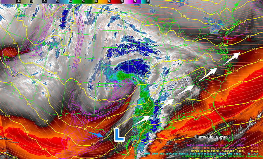
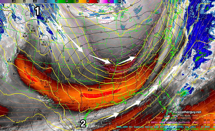
Posted Wednesday 01/17/24 @ 4:12 PM — An interesting development with this coming storm, as captured by today’s ensemble models and mentioned yesterday in the water vapor image caption.
It appears that the two low pressure systems will merge into one, with the possibility of throwing back additional moisture into our area.
Additionally, we will be in a enhanced area of vertical upward motion caused by the jet stream, specifically an area that’s called the “left exit region of the jet streak”.
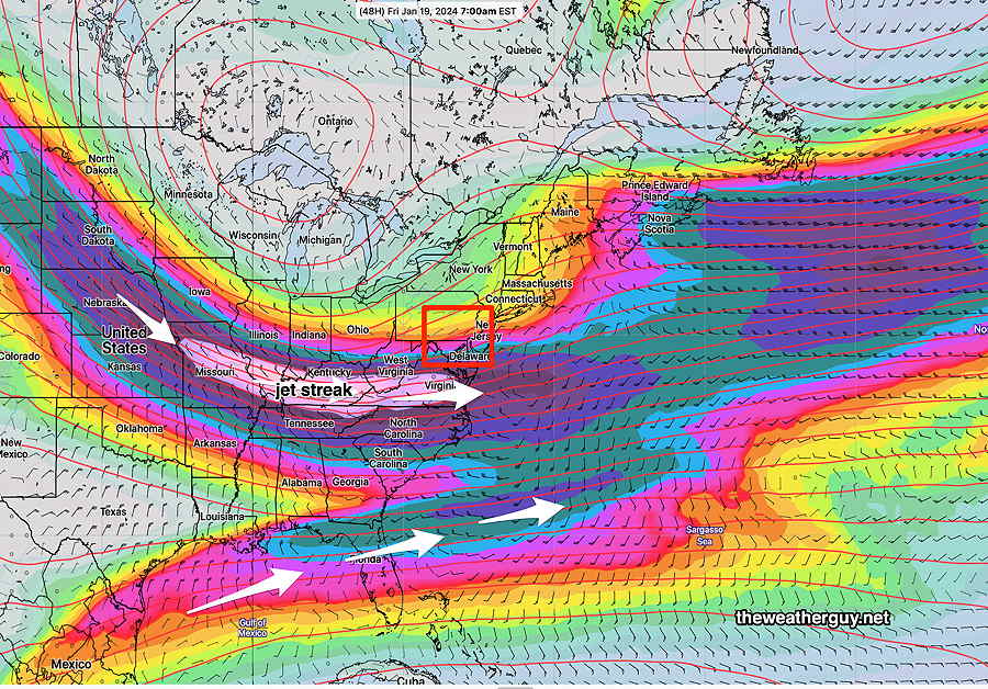
This usually results in enhanced precipitation in this region.
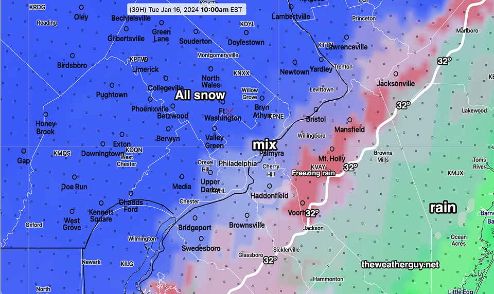
Plenty of cold air should limit changeover to sleet and freezing rain to eastern NJ.
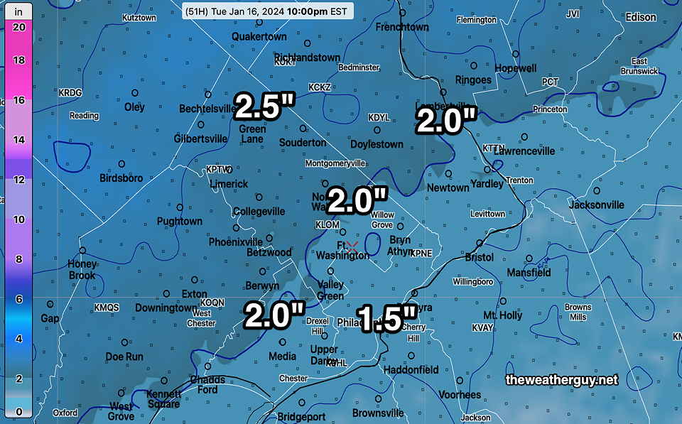
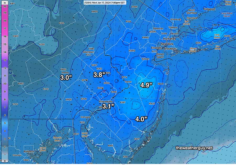
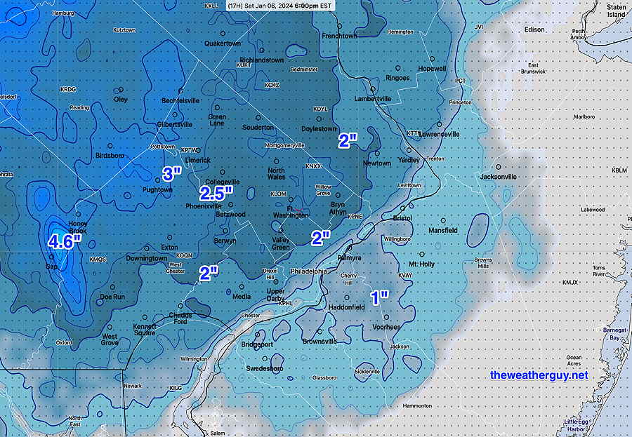
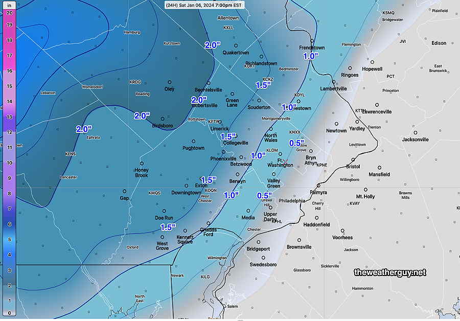
Putting this all together, I’ve assembled a new best estimate map of the expected snow totals—
There’s still plenty of time for the models to change, but the ingredients are there for a larger storm.
Stay tuned.
Friday’s Snow
Posted Wednesday 01/17/24 @ 9:26 AM —The expected storm is still in the range of just a few higher resolution models (84 hour forecast range) but by later this afternoon, we’ll be entering into the range of most of the short range high resolution models ( 48 -60 hours).
Here’s the current view—
• This will be all-snow, no expected changeover to sleet of freezing rain in the immediate PHL area, except at the immediate shore. Low temperatures will result in higher snow-water ratios.
• The Global models (GFS, ECMWF, ICON, CMC) are forecasting a generalized 2″ – 2.5″ snowfall, beginning with light snow before daybreak Friday and getting heavier in the morning and into early afternoon.
• The shorter ranger models (NAM CMC-RGEM), both 84 hour forecast models, are closer to 2.5″- 4.5″
• The few 60 hour models (NAM-NEST, experimental RRFS) forecasts don’t include all of the duration of the storm but they’re suggesting 2.5 to maybe 3″.
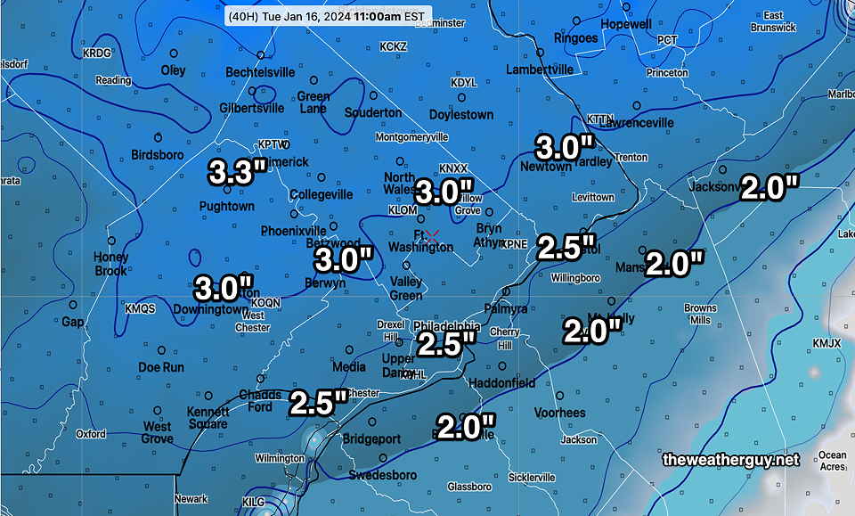
So, at this point I’m thinking a likely 2.5-3″ snowfall, but it would not surprise me if this goes closer to 4″, and maybe 5″, northwest suburbs. The latest CMC-RGEM captures that forecast—
I’m providing this just as a first “guesstimate”. I’ll be updating later today.
Another Similar Snowfall Friday?
Posted Tuesday 01/16/24 @ 10:06 PM — The Friday time frame has just entered into the range of the somewhat higher resolution models (84 hours).
Here’s the latest NAM, just available—
Things will change by Friday. Stay tuned.
Posted Tuesday 01/16/24 @ 7:40 PM — Following very cold weather for both Wednesday and Thursday, Friday appears to be shaping up for another rather similar storm like we had today. I’ve been covering it on my Winter Outlook Page
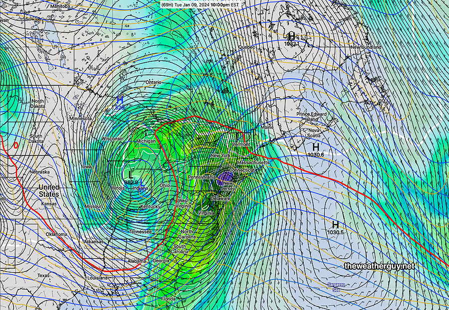
Still much uncertainty as this storm will again consist of two centers, one coastal and one inland. Some models are suggesting 3-4 inches of snow. Way to early to know for sure.
The energy for these systems are visible on satellite water vapor imagery—
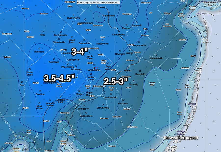
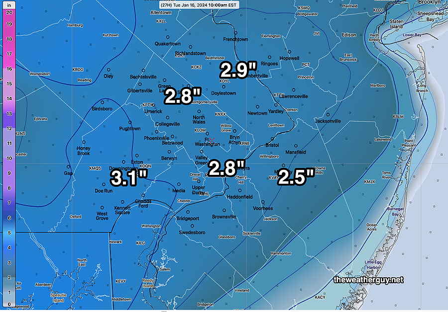
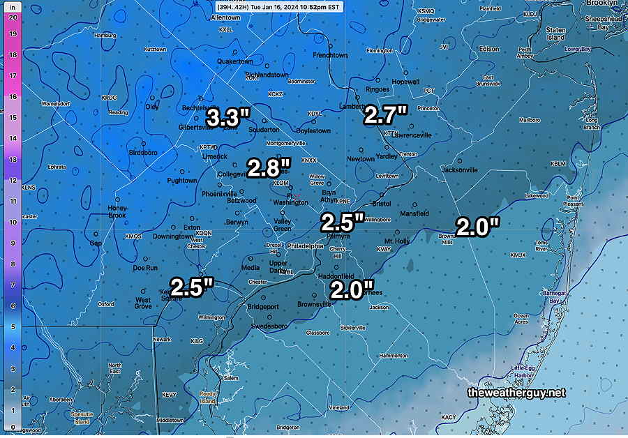
Tuesday – Wednesday
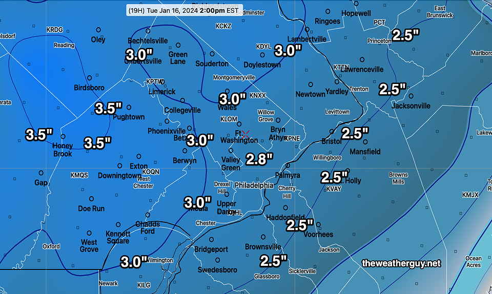
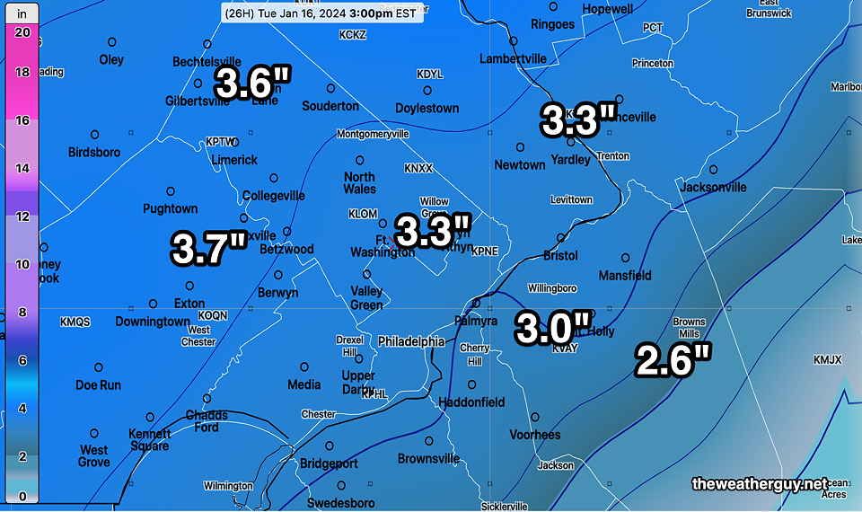
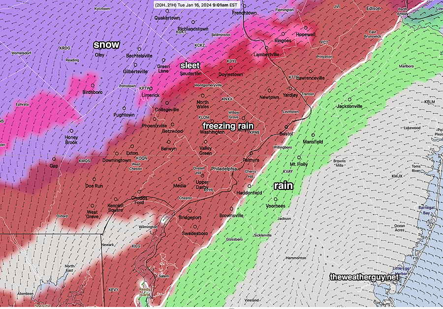
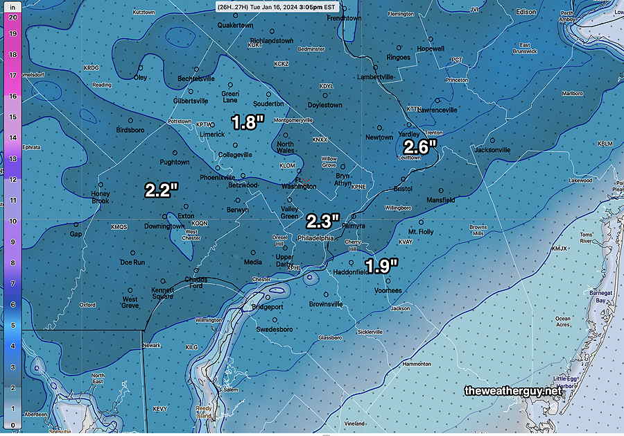
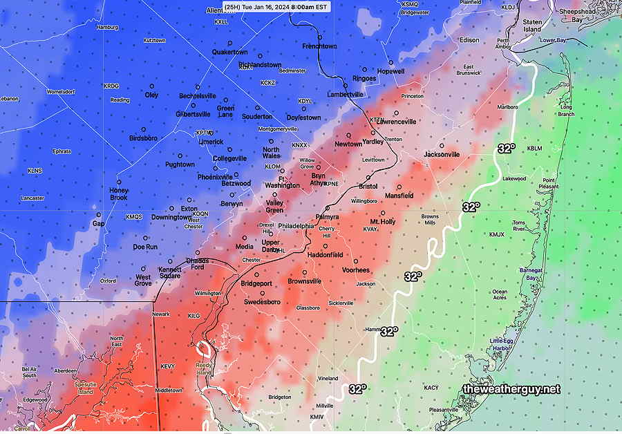
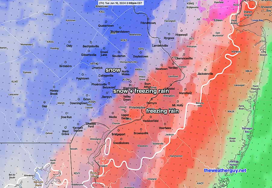
Posted Tuesday 01/16/24 @ 9:56 AM —Light precipitation, mostly freezing rain, possibly changing back to snow flurries until about 2-4 PM. It remains cloudy for the balance of the day, maybe some reduced cloud cover before sunset.
Wednesday looks to be clear and cold. Highs in the 20s.
In fact, it looks like we remain in winter’s grip through the coming weekend. Some winter weather possible Friday, covered in the Winter Outlook Page.