#Philadelphia #weather #PAwx
Sunday Forecast Update
Posted Sunday 02/18/24 @ 9:42 AM — Sunny and windy today. The cloudiness that I thought would impact northern areas today will remain even further to our north. Highs 41-43º. Wind gusts near or over 30 mph.

This Week’s Peek
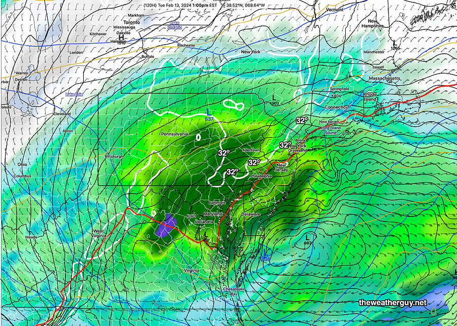
The coming week looks tranquil. A coastal storm has been consistently forecast for this Friday. It looks like rain, not snow here—
Philadelphia Inquirer Article on the Snow
Sunday’s Philadelphia Inquirer had an article on the snow forecast that didn’t quite make the grade. I would have added a comment about the ground temperatures that were well above freezing and melted much of what fell initially and allowed accelerated melting in the morning.
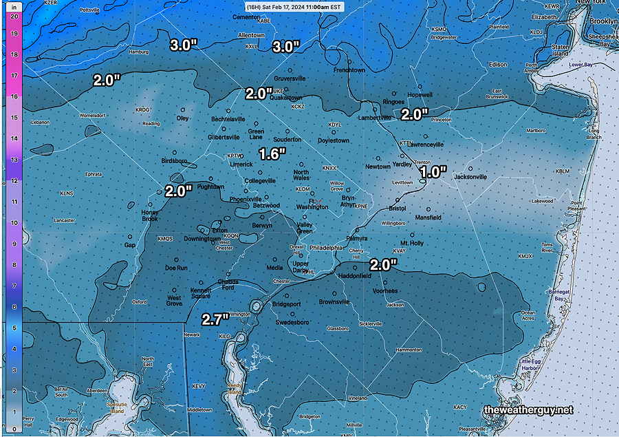
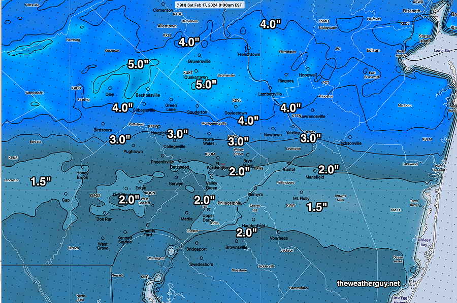
It looks like many areas did receive snowfall as predicted by yesterday’s forecasts. (The snow totals reported to the NWS can be found here.)
Most were in the 2-4 inch range. Areas far north received over a foot of snow.
Montgomery county: 1″ – 4.2″
Delaware county: 3″ – 4″
Chester county: 1″-4.8″
Bucks county: 1″-13″
Philadelphia county: 2.3″ -3.5″
With soil temperatures and surface temperatures so warm and radiant energy from the sun causing a melt, it’s been amazing how fast the snow has disappeared today. I measured 2.7 inches at my home at 8 AM, but by noon, there wasn’t any snow to shovel from our sidewalk. The part of our driveway that gets the sunshine had nothing to shovel either.
I’ve learned something from this storm. Surface (skin temperatures) and ground soil temperatures play a large part in how impactful a snowfall will be. Most of my focus has always been on temperatures at different levels of the atmosphere and whether the precip will fall as rain, sleet, or snow.
In the future I am adding a review of soil ground temperatures to my forecast checklist. (The models have that information and today I added it to my HRRR data downloads.) With our milder winters and longer periods of warm weather between storms, the residual heat in the ground will require greater attention.
• Temperatures remained well-above freezing before the storm (35º Blue Bell Wings Field) until it started snowing at 12:15 AM.
• Temperatures remained somewhat warmer than predicted throughout the storm.
• Ground temperatures (‘skin temperatures and soil temperatures”) were above freezing for much of the storm near the city.
• Precipitation amounts (in water) were very different from what was predicted.
• Banding of precipitation and snowfall occurred far north of our area.
The MRMS summary gives a handle on how much precipitation (water or water equivalent) actually fell and where—
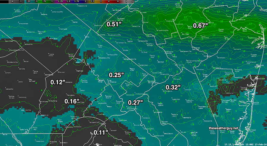
From the above, we can see that the storm’s precipitation occurred in the city and immediate suburbs in the range forecast (0.30″) , but south of the city in Delaware county and Chester counties, precipitation was much lower than forecast. The banding occurred far north with heavy snow in that region.
It’s funny. I pointed out that the media weather people were under-forecasting the snowfall. Eventually they raised their forecast to a “Winter Storm Warning” last night, only to see that their original forecast was probably better.
Meanwhile, I saw signs of this forecast change, in last night’s HRRR, but I was reluctant to call it and attributed the reduction in snow to model spin up errors. Go figure.
Snow Update
Posted Friday 02/16/24 @ 9:00 PM — Some trends are becoming apparent in reviewing additional models. The high snow accumulation values predicted this morning and this afternoon have been eroding downward.
The latest HRRR (00z) just available more than captures this significant downward tend—
When I saw the trends with tonight’s HRRR and other afternoon models, I wasn’t sure if I would post it. I can think of many good forecasts that were derailed by my posting the ‘latest model’ and going with it.
There is a known phenomenon called “model spin up time”. Basically, it takes several hours before model forecasts become accurate They can take as long as 6 to 10 hours to be valid in an area, especially when a storm is on one’s doorstep. Put another way, the ‘latest model’ is often inaccurate in the short term. That could be the case here.
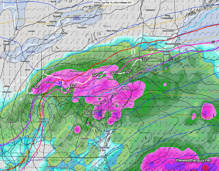
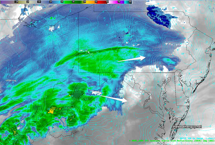
The latest satellite and radar shows the storm may be splitting into two centers, explaining the HRRR’s corridor of low snowfall above.
I guess we’ll find out when we wake up tomorrow morning.
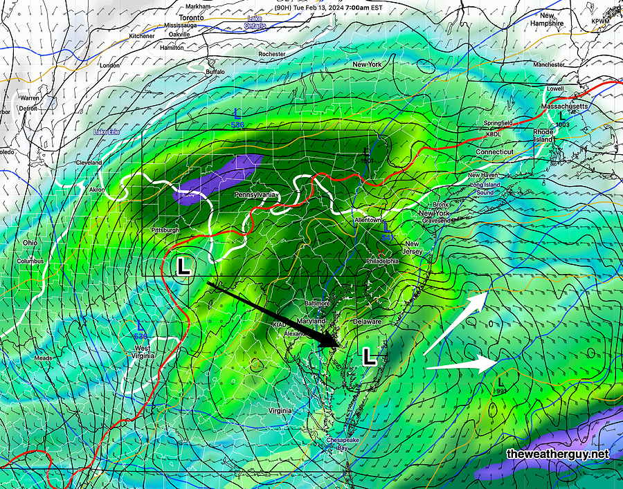
Originally Posted Fri @ 4:57 PM — —A fast moving storm will bring snow to our area tonight (Friday) late evening and night. The storm is visible on WV imagery—
The light snow will move in from the west as early as 11 PM, but most models have it moving in about 1 AM.
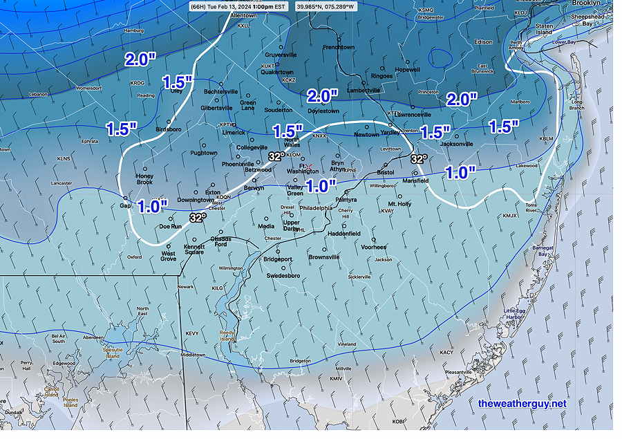
Some banding in snowfall has been expected to develop and the heavier snow is now forecast to be north of the city, instead of south of the city as forecast earlier. A generalized 1.5-5 inches of snow is expected.
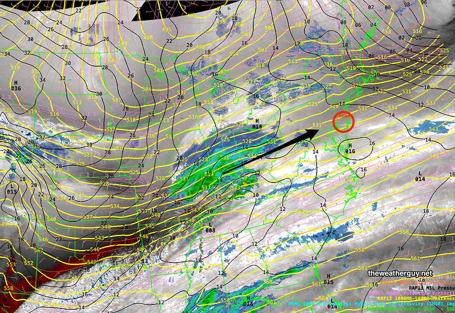
As is always the case, the models differ in their placement of the heaviest snowfall. Here’s the latest HRRR (18z) —
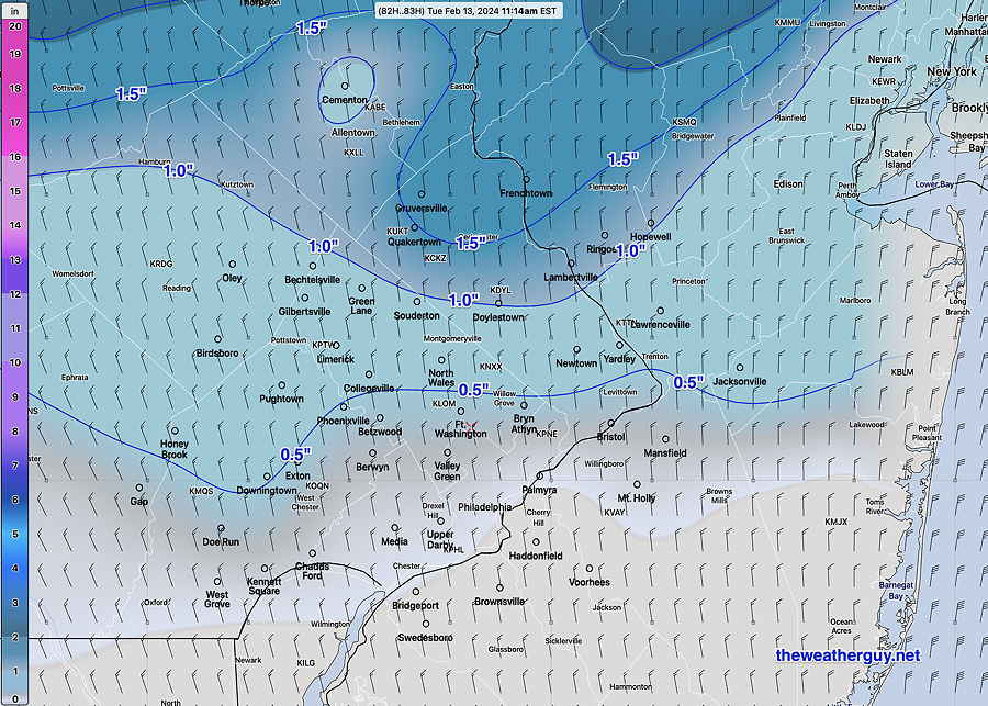
Many long time followers of this blog know my preference for the NAM for snowfall forecasts here. Here’s the latest NAM (18z)—

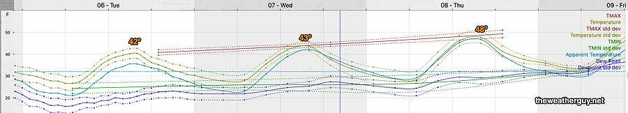
Saturday
The storm ends by 7-9 AM in most areas Saturday morning, but instability cloudiness and snow flurries may be with us for much of the morning and even some of the afternoon. From this morning’s update—
• Snow starts about midnight tonight (Friday).
• Snow tapers off west to east about 7-9 AM Saturday.
• Some light snow showers or flurries possible, especially western sections, until about noon.
• Windy and gusty mid day Saturday.
• Unsettled skies – Clouds with breaks of sun during the afternoon, but with another possible area of snow flurries passing through.
NBM high temperatures: Blue Bell 37º Philadelphia 38º
uncertainty average (based on standard deviation): ± 1.8º
Sunday
Sunny early but with cloudiness moving in late morning, especially areas north of the city due to an upper air disturbance. Rather windy.
NBM high temperatures: Blue Bell 38º Philadelphia, 40º
uncertainty low (based on standard deviation): ± 1.6º
Monday
Sunny but still with temperatures a bit below season averages
NBM high temperatures: Blue Bell 41º Philadelphia, PA 43º
uncertainty average (based on standard deviation): ± 2.0