Category Archives: Philadelphia Area Weather Forecasts

WEEKEND WEATHER FORECAST

#Philadelphia #weather #PAwx

Sun 6:37 PM —Forecast Review —Thunderstorms developed an hour or two earlier than forecast and somewhat further west than forecast. Here’s the MRMS rainfall totals —
MRMS rain-gauge measured rainfall combined with rain-gauge calibrated and interpolated radar-based summary of ACTUAL RAINFALL RECEIVED. Color shading is in inches. Line contour numbers are in mm. (25.4 mm= 1 inch)      (Click on image for a larger view.)

Posted Sunday 07/14/24 @ 11:35 AM

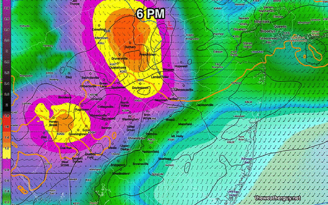
Some of this morning’s models are showing an increased possibility of isolated severe thunderstorms. Not all areas will have a thunderstorm. The time window has increased from 3 PM to 9 PM.

Posted Sunday 07/14/24 @ 8:02 AM

Several ingredients are coming together Sunday afternoon that will result in thunderstorms in our area, especially from Philadelphia and eastward. An upper trough, and thermal instability with high moisture will allow thunderstorms to develop from Lehigh county in the early afternoon to the Philadelphia area eastward into central NJ between 4 an 6 PM. Some scattered activity is possible through 8 to 9 PM.

HREF probability of thunderstorms. The entire area could see isolated storms as early as 1-2 PM and as late as 8 PM, but the highest probability of scattered storms will be in the red area at about 4-6 PM. (Click on image for a larger view.)

While heavy rain and gusty winds can occur with most thunderstorms, these storms can be strong, but not necessarily ‘severe’.

Posted Saturday 07/13/24 @ 9:50 PM

A weak upper air trough will move through late Sunday afternoon, triggering scattered thunderstorms in the Philadelphia area. Peak probability is 4 PM-6 PM. A few may be strong. Look for an update Sunday morning.


Sat 8:42 AM —Forecast Review —It’s hard to remember a recent past forecast that was as much of a bust as the forecast for last night and this morning.

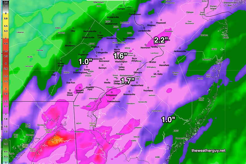
Incredibly, every model, including those run at 00z (8PM EDT) and become available hours later (often after 11:30 PM EDT) continued to show heavy rain for the early morning hours in the immediate Philadelphia area.

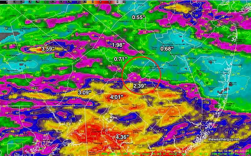
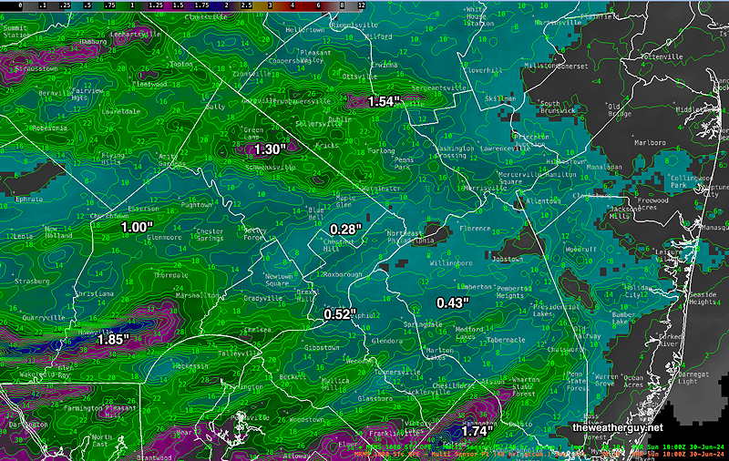
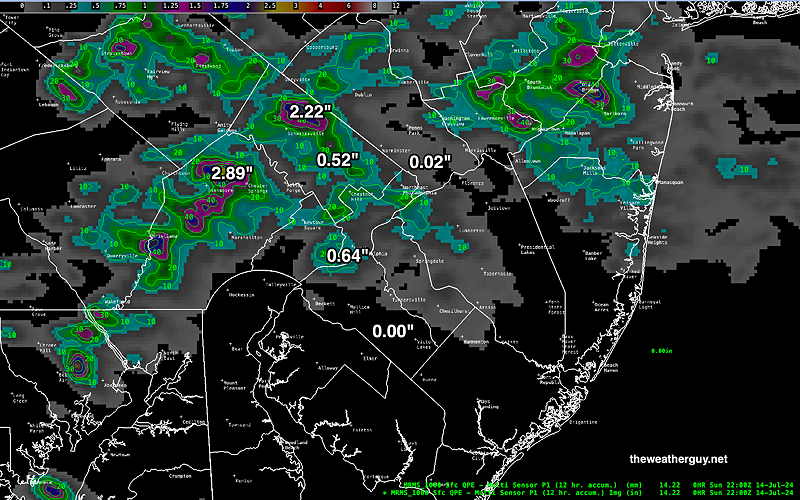
Here’s the rainfall that fell over the past 12 hours, from 8 PM to 8 AM—

MRMS rain-gauge measured rainfall combined with rain-gauge calibrated and interpolated radar-based summary of ACTUAL RAINFALL received. Color shading is in inches. Line contour numbers are in mm. (25.4 mm= 1 inch)      (Click on image for a larger view.)

Clearly, the precipitation actually received doesn’t really approach any of the model forecasts posted yesterday.

So what could cause so many different models to be so wrong? This precipitation originated from a moist flow around high pressure in the Atlantic. There are relatively few direct measurements of pressure, moisture and temperature, especially vertically into the middle and upper atmosphere, in that region.

While new satellite techniques are used to infer and indirectly measure this some of this missing data, clearly there were errors and missing information. So the input conditions, especially in the middle and upper atmosphere were incomplete causing the model “initialization” to be wrong.

While numeric weather prediction has come an incredibly long way in the past 50 years, it simply can’t compensate for wrong or missing initial conditions. Can machine learning and AI, take it to a new level? I’m a little skeptical, especially with missing input information. I guess we’ll see.

Previously Posted Fri 5:50 PM —As posted earlier today, the heavy rain expected in the Philadelphia area did not materialize as forecast, but the heavy rain developed near the eastern shore of NJ (see here) with some extremely heavy downpours.

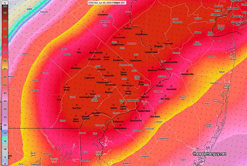
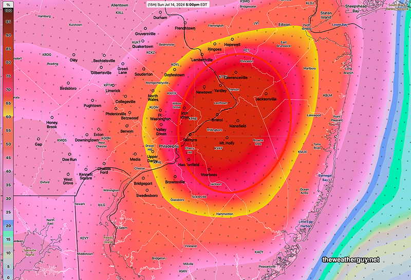
The latest model blend (NBM ) still shows significant rain for the immediate Delaware Valley, mostly occurring late Friday night into the morning hours on Saturday—

18z NBM total rainfall through Saturday (Click on image for a larger view.)

With the Friday forecast such a bust, I’d say this is a low confidence forecast. Nonetheless, the NBM is supported by the latest HREF which just became available.

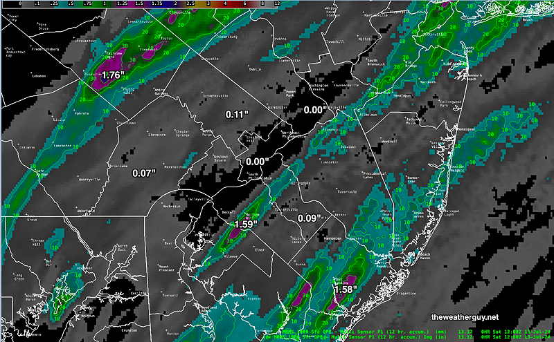
On the other hand, the latest Canadian RGEM, also just available, shows a heavy axis shifted eastward-

18z Canadian RGEM model total precipitation (Click on image for a larger view.)

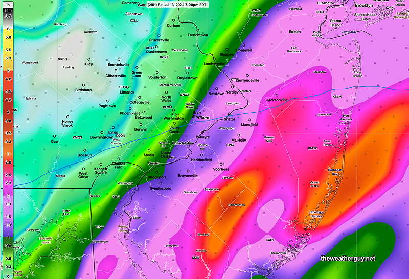
I’m leaning towards the RGEM, but who knows? 🙂

Saturday

Rain through the morning, ending from west to east, noon through 2 PM in the Delaware Valley, and as late as 5 PM at the shore. Some sunshine is likely here in the afternoon. Very humid!

NBM high temperatures: Blue Bell, PA 87º Philadelphia, PA 88º
uncertainty (based on standard deviation): ± 2.3º (higher than average)

Sunday

Mostly sunny, hot and humid. Heat indices near 100º

NBM high temperatures: Blue Bell, PA 93º Philadelphia, PA 94º
Uncertainty (based on standard deviation): ± 1.9 (average uncertainty)


WEEKEND WEATHER FORECAST

#Philadelphia #weather #PAwx

Posted Sunday 07/07/24 @ 10:02 AM — I’m glad the past two day’s forecasts have been essentially unchanged and on autopilot, as I’ve been focusing my attention on fixing and fine-tuning some model download issues.

Today’s (Sunday) weather will be continued hot, in the mid 90s. A sea breeze moisture convergence zone will set up as its done the past two days. Some isolated storms may develop, as was the case yesterday, east of us (NJ) during the late afternoon.

Today’s NBM 12z thunderstorm coverage forecast for 5 PM – yellow area = isolated. (Click on image for a larger view.)

Temperatures will reach the mid and upper 90s

NBM High temps Sunday (Click on image for a larger view.)
NBM Apparent Temperatures Sunday (Click on image for a larger view.)

90º+ temperatures are forecast this entire week. Things get interesting Wednesday into Saturday as moisture from Beryl moves northeastward and a stalled front may focus some much-needed rainfall here.


Previously Posted Fri 5:02 PM —A hot humid flow will remain over us through tonight and through Saturday evening.

Scattered showers and pop up thunderstorms will remain mostly north and west, although some models show some activity with a sea breeze line that sets up in NJ Friday evening.

A cold front will move through Saturday late evening with a line of showers and thunderstorms. The front slows down and additional showers may develop during the nighttime hours. Slow clearing.

Just as I was going to post this, the afternoon models are becoming available. These models have eliminated most of the showers Saturday evening. So we may have a dry frontal passage.

The air on Sunday will be less humid and only slightly less hot.

The edge of the drier air is visible on satellite water vapor imagery—

Friday’s Water Vapor image shows the edge of the drier air in northwest Ohio. I’ve drawn the approximate position of the cold front.

Saturday

Sunny and continued hot and humid. High cirrus clouds and some periods of thicker clouds. Scattered showers and thunderstorms as early as 4-6 PM, but the most organized activity about 8-11 PM. As mentioned above, the afternoon models seem to have eliminated the showers from the forecast. A significant forecast change if true.

NBM high temperatures: Blue Bell, PA 93º Philadelphia, PA 95º
uncertainty (based on standard deviation): ± 2º

Sunday

The front slows down. Partly cloudy, partly sunny. Decreasing humidity.

NBM high temperatures: Blue Bell, PA 92º Philadelphia, PA 93º
uncertainty (based on standard deviation): ± 2.5º


WEEKEND WEATHER FORECAST

#Philadelphia #weather #PAwx

Weekend Rainfall Summary

Here’s the 48 hour weekend rainfall summary. Includes Saturday and Sunday. Some areas received plenty of rain; others, not so much.

MRMS rain-gauge measured rainfall combined with rain-guage calibrated and interpolated radar-based summary of ACTUAL RAINFALL received. Color shading is in inches. Line contour numbers are in mm. (25.4 mm= 1 inch)   Red circle is the immediate Philadelphia area.    (Click on image for a larger view.)

Sunday Forecast Update

Often associated with severe thunderstorms and even tornadoes, a sky of mammatocumulus clouds (also referred to as mammatus clouds) was visible before sunset tonight—

mammatocumulous clouds at sunset. (Click on image for a larger view.)

Posted Sunday 06/30/24 @ 11:12 AM

This morning’s models continue with the forecast of heavy rain between 5 PM and 8 PM, but there’s the possibility of of showers and thunderstorms throughout the afternoon.

Posted Sunday 06/30/24 @ 8:59 AM — The latest HRDPS shows extremely heavy rain rates develop over Philadelphia between 6 and 8 PM tonight—

06z Canadian HRDPS shows extremely heavy rain rates develop over Philadelphia between 6 and 8 PM tonight. (As we’ve often seen, the actual exact placement and timing can often differ from the models. but it suggests a fairly good bet that we’ll get some heavy rain tonight.) (Click on image for a larger view.)

Sun 6:55 AM —Forecast Review — Last night’s rains were not as strong as originally forecast and came in two waves; the first diminished in intensity as it approached Philadelphia and headed northeastward.

The main group arrived after midnight, as forecast, and dropped light to moderate rainfall with a few localized heavier areas. Here’s the MRMS rainfall summary —

MRMS rain-gauge measured rainfall combined with rain-guage calibrated and interpolated radar-based summary of ACTUAL RAINFALL received. Color shading is in inches. Line contour numbers are in mm. (25.4 mm= 1 inch)      (Click on image for a larger view.)

For today, Sunday, a very moist and unstable airmass will produce thunderstorms as a cold front approaches from the west. Some widely scattered storms are possible anytime after noon time, mostly north of the city, but the heaviest activity will be from 5 PM to 9 PM in the immediate Philadelphia area. Higher instability values (CAPE, helicity and vertical shear) may result in some storms being severe. Localized heavy rain is possible.

06z HREF shows hourly probability of strong radar echoes at 7 PM. Much of the area has high probability. (Click on image for a larger view.)

Weekend Forecast Updates

Posted Saturday 06/29/24 @ 5:37 PM

Another shift in the forecast with tonight’s storms significantly diminishing in intensity as they approach the immediate Philadelphia area.

Posted Saturday 06/29/24 @ 1:28 PM

This morning’s models are trending towards the showers and thunderstorms approaching the Delaware Valley area earlier than previously forecast— as early as 9-10 PM Saturday evening and the main batch moving in between 10 PM and 1 AM. Scattered storms may persist until 4 AM.

Moisture levels (precipitable water) is approaching 2.4″ which is almost tropical— Heavy rain and gusty winds are possible with any storms and based on elevated shear and helicity values, storms could be severe.

Posted Saturday 06/29/24 @ 10:07 AM

Some sprinkles have broken out in some areas, but they may not be reaching the ground. These should dissipate and a mix of sun and clouds for most of the late morning and early afternoon.

Radar and MRSMS combined at 9:42 AM. These sprinkles should dissipate this morning. (Click on image for a larger view.)

Showers and thunderstorms expected between midnight and 3 AM Sunday morning. Additional showers and thunderstorms expected Sunday mid to late afternoon into the evening. Heaviest activity expected in NJ.


Posted Friday 06/28/24 @ 10:34 PM

Tonight’s NAM-Nest is suggesting low clouds and possibly some drizzle early Saturday morning. Skies should brighten by afternoon.


Previously Posted Fri 5:47 PM —A warm front with a strong flow of moisture ahead of it will move through Saturday night and a cold front will move through later Sunday afternoon or evening. Both features are visible on this afternoon’s satellite water vapor imagery—

Friday afternoon’s water vapor imagery shows the two main systems that will affect our weather this weekend. A warm front with significant moisture followed by a cold front. I’ve drawn the current positions of the cold front and warm front. (Click on image for a larger view.)

Saturday

Saturday presents a difficult forecast challenge. When it comes to warm fronts, the degree of cloud cover ahead of the front can be tricky to predict. A best guess is that it will be cloudy in the morning Saturday, giving way to some bright spots through high clouds late morning into very early afternoon. Then increasingly cloudy mid to late afternoon into evening.

Regarding showers, the latest ECMWF the NAM-NEST and the model blend (NBM) show very light, widely scattered showers possible in some places during the mid to late afternoon. Most areas will be dry during the daytime.

Heavy rainfall with thunderstorms are expected late Saturday evening into the predawn hours of Sunday with the actual warm front. Heavy thunderstorms expected 1 AM- 4 AM. Incredibly, the latest HRRR has the heavy activity skipping past the immediate Philadelphia area. So there’s uncertainty with the rainfall as well.

Highs 85º (Blue Bell) 87º (Philadelphia). Average uncertainty. Very humid with dew points into the low 70s.


Sunday

Following the warm front passage, clouds in the morning break for hazy sunshine by the afternoon. Heavy thunderstorms late afternoon or evening.

Highs 90º (Blue Bell) 93º (Philadelphia). Higher than average uncertainty ± 2-3º Very humid and uncomfortable with dew points into the mid 70s.