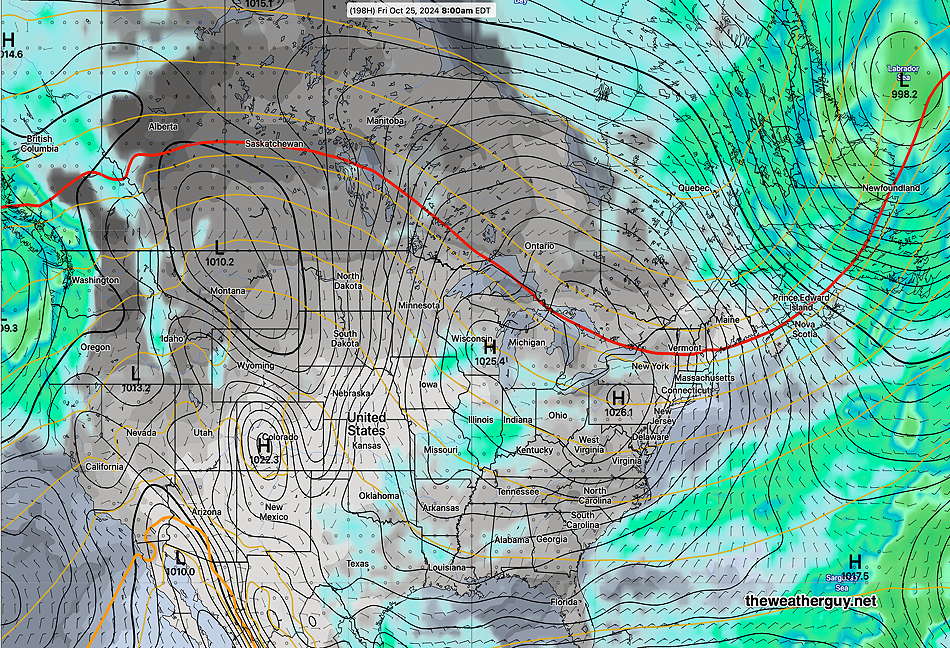
Posted Thursday 10/17/24 @ 11:26 AM — The latest extended range models are in good agreement and currently show little to no rain (and certainly no meaningful rainfall ) through Oct 29th.
10-17-24 06zGEFS cloud (dark grey) and precip for next Friday, High Pressure dominates the US (Click on image for a larger view.)
The ECMWF-AIFS, which was impressive with its predictions of Helene and Milton, shows no tropical development to affect the mainland US within the next week or so.
Yet Another Pattern Change But NO Rain
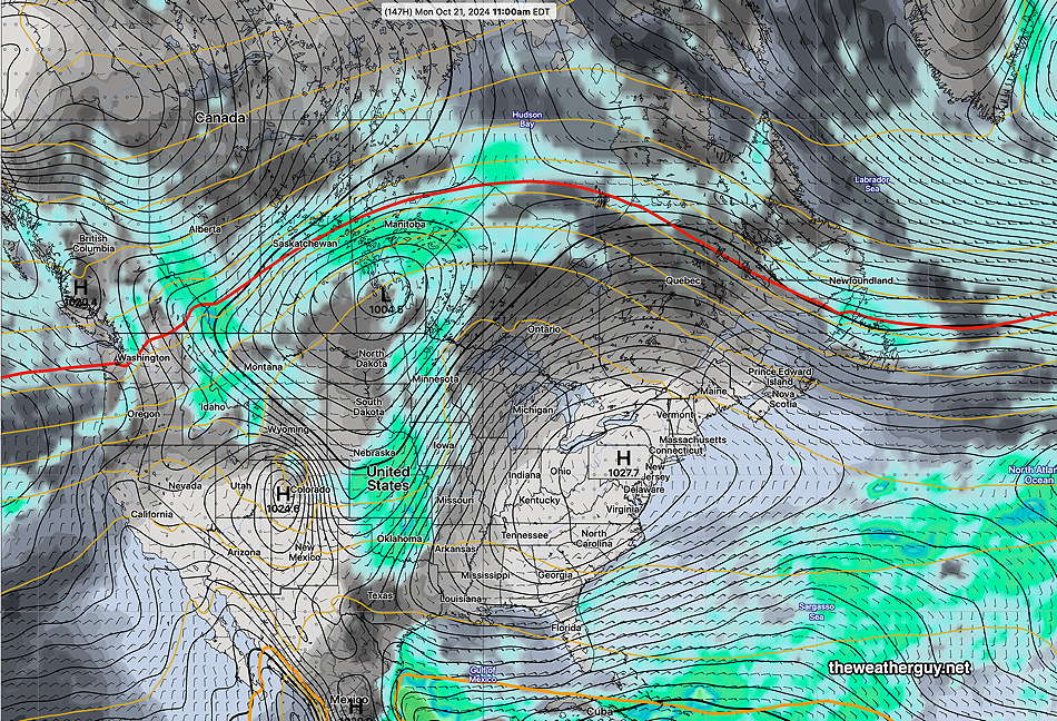
Posted Tuesday 10/15/24 @ 5:09 PM — The cold upper air trough will dissipate by the end of the week. Troughs often spawn low pressure, and the current trough will spawn a low that will form off the coast, not giving us any rain.
The upper ridge in the central US will move over us by the weekend and the upper ridge will be with us through most if not all of next week. NO rain expected through at least the end of next week.
Here’s what we’re evolving into by next Monday. A broad ridge across the continental US and dry high pressure over us—
10-15-24 12z GEFS forecast for next Monday. This is stagnant through all of next week. Not a drop of rain!
A Pattern Change
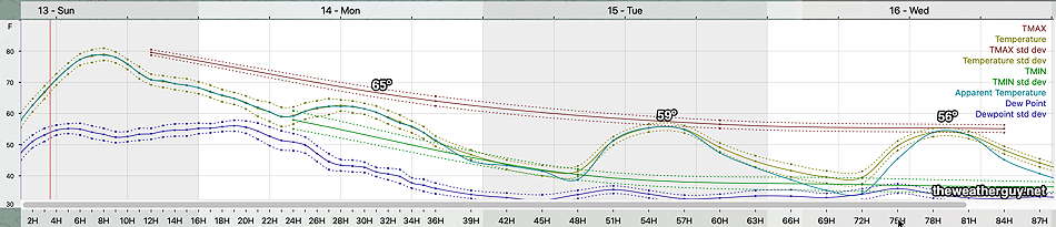
Originally Posted Sun @ 4:21 PM — —The models are showing signs of an evolving pattern change beginning this week. Most obvious will be a developing trough in the the northeastern US giving us much cooler temperatures following a cold front passage tonight.
NAEFS for Wednesday. Cold upper air trough over the northeastern US. (Click on image for a larger view.)
10-13-24 12z NBM temperatures and dew points through Wednesday. Signficant drop in high and low temperatures (Click on image for a larger view.)
A cold front moves through tonight. Showers associated with this front will likely stay to our north. A few models vacillate on whether the Philadelphia area will see any showers or sprinkles with an upper air disturbance that moves through Monday morning. If we get anything, it will be scattered and very light.
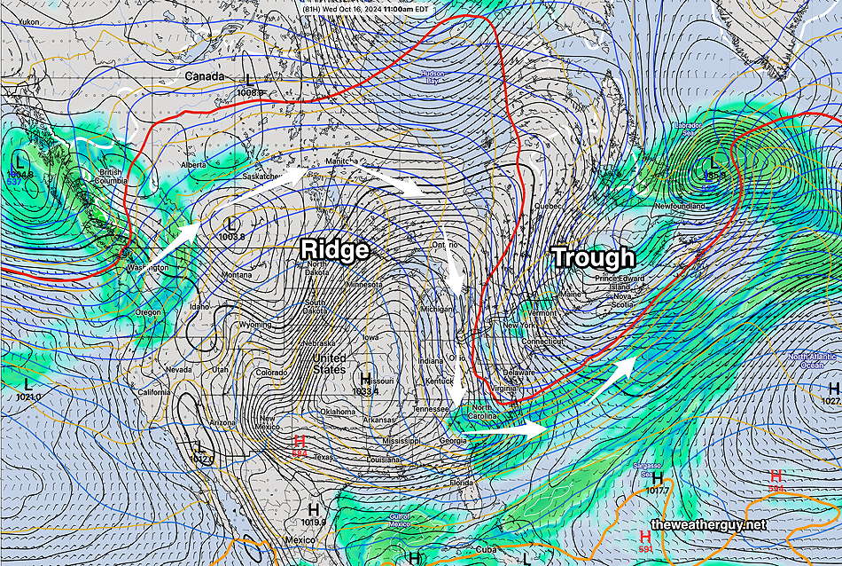
The upper trough for the first part of this week may cause some instability cloudiness, perhaps more than the models are showing.
With the upper blocking ridge in the central US breaking down by the end of this week, we may finally see some systems by next week bring us some rain. although I don’t see any specific system yet in the extended range models.
Posted Saturday 10/12/24 @ 10:48 AM — Cancel those showers for Sunday night. Both the GFS and ECMWF now show less of an upper trough and weaker low pressure development. The very dry weather to continue.
Originally Posted Fri 5:36 PM —With a high pressure ridge and upper air trough seemingly unchanging in previous models runs, I’ve been taking a break from forecasts for the past two days. However, weather being what it is, things have changed and it seems there may actually be a chance for some rain late Sunday or Sunday night.
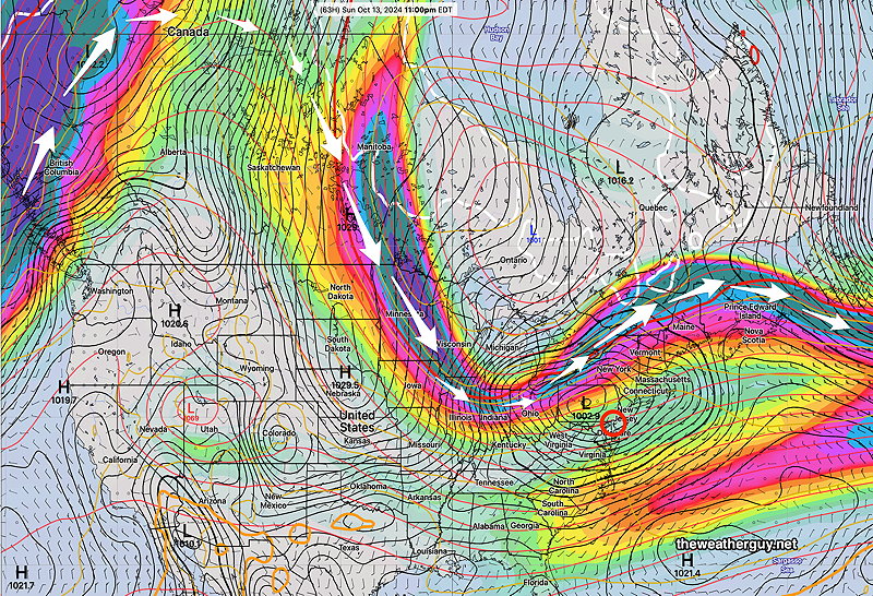
NAEFS forecast for Sunday at 11 PM Upper jet stream trough spawns low pressure over PA (Click on image for a larger view.)
We’re expected to be under the influence of an upper trough by Sunday and low pressure is expected to develop right over western Pennsylvania by Sunday evening.
While we’re still not located in the most favorable position for rain relative to the jet flow, the latest GFS is cranking out some rain Sunday night! Not a lot, about 1/4 of an inch, but we’ll take anything we can get.
10-11-24 12z GFS forecast for 2 AM Sunday. Low pressure with an area of rain. (Click on image for a larger view.)
Saturday Forecast
Sunny and quite nice. Some high thin cloudiness moves in late afternoon.
NBM high temperatures: Blue Bell, PA 74 º Philadelphia, PA 76º Uncertainty (based on standard deviation): High confidence
Sunday Forecast
Considerable cloudiness far northern suburbs, mostly sunny closer to the city. Increasing cloudiness late afternoon. Cloud cover will affect high temperatures reached.
NBM high temperatures: Blue Bell, PA 77º Philadelphia, PA 79º, maybe 80º Uncertainty (based on standard deviation): slightly below average confidence.
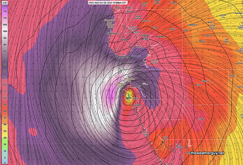
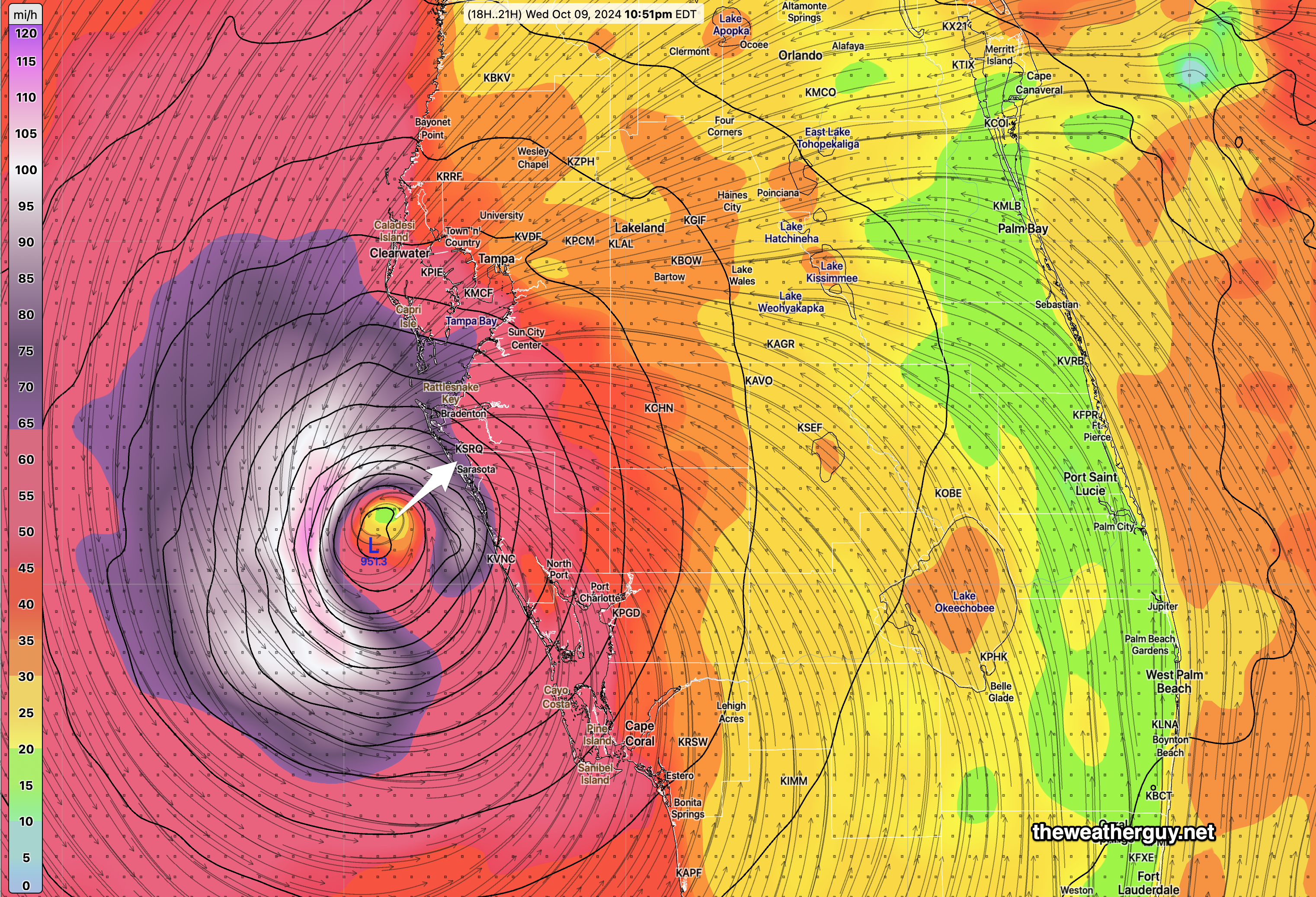
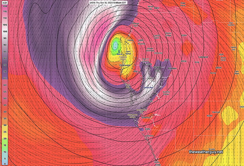
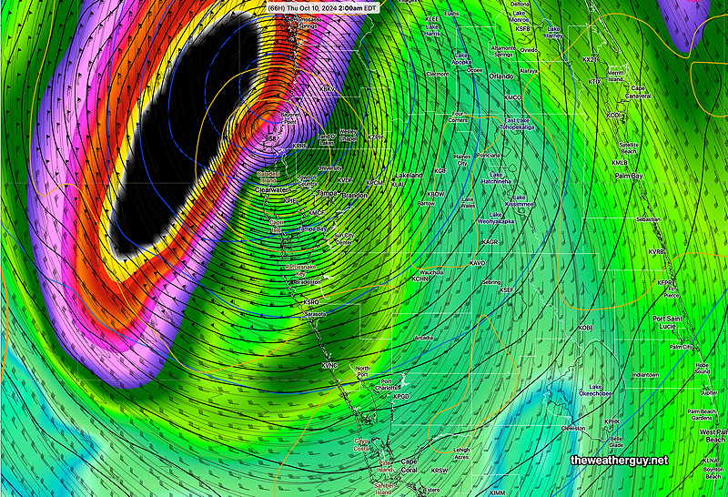
Posted Wednesday 10/09/24 @ 4:31 PM —The latest models are suggesting Milton will make landfall between 11 PM and midnight, just south of Tampa Bay, possibly closer to Sarasota—
12z HAFS B wind/pressure forecast for 11 PM tonight. Landfall between Sarasota and Tampa Bay. (Click on image for a larger view.)
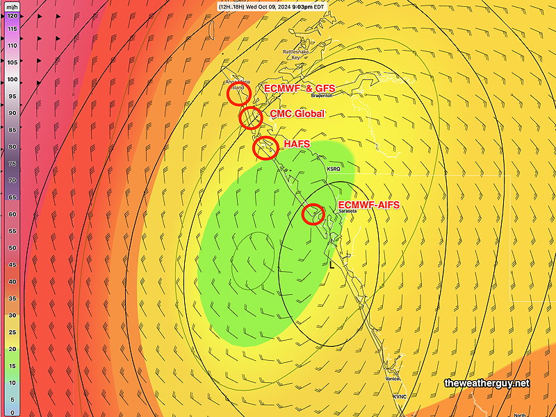
There remains uncertainty in the exact location of landfall. Here’s a few models—
Milton Landfall – various models (Click on image for a larger view.)
Hurricane Milton Update
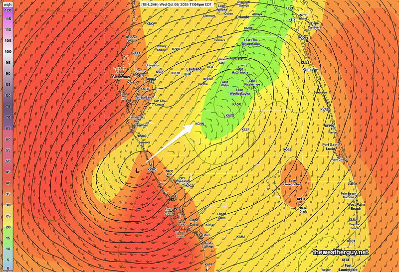
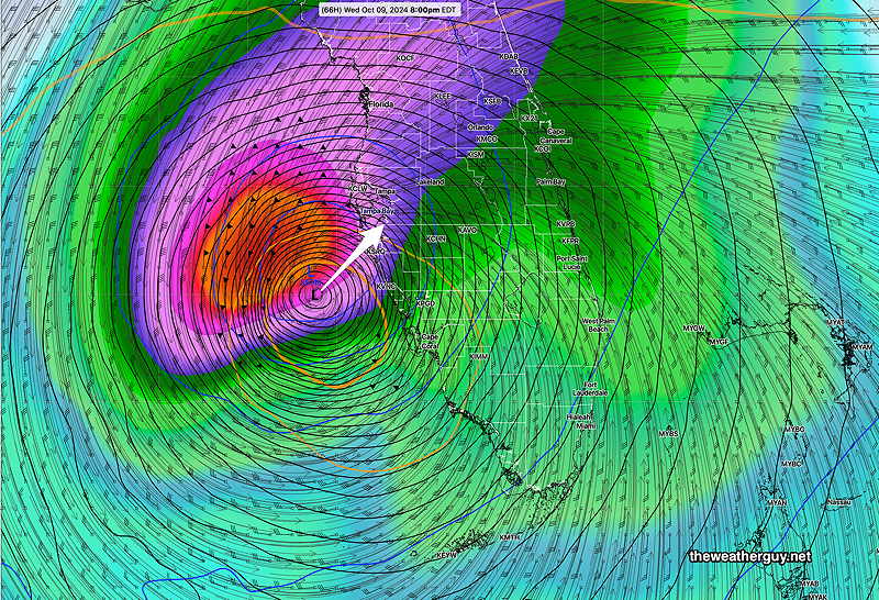
Posted Wednesday 10/09/24 @ 9:55 AM —Both the latest ECMWF AI model and NOAA’s newest hurricane model, the HAFS B, has Hurricane Milton making landfall between 10 PM and midnight south of Tampa Bay, closer to Sarasota—
The latest HAFS B model wind/pressure forecast for ~10 PM tonight (Click on image for a larger view.)
Here’s the ECMWF-AIFS has been consistent with this landfall location—
06z ECMWF-AIFS wind/pressure forecast for ~ 10 PM tonight (Click on image for a larger view.)
The hurricane intensity models all have Milton downgrading to a Category 3 before it makes landfall.
A landfall south of Tampa Bay may be better for the Bay area as wind flow will be westward instead of eastward in that region. It will be worse for Naples, Venice, etc.
Hurricane Milton Update
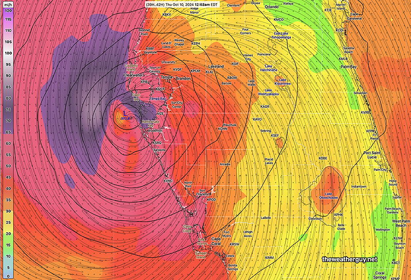
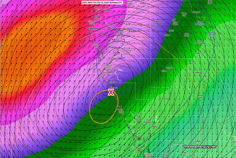
Posted Tuesday 10/08/24 @ 4:27 PM — The latest ECMWF has delayed Milton’s landfall until 7 AM Thursday morning, closer to Sarasota. The AI version is similar—
12z ECMWF Milton landfall around 7 AM Thursday morning just north of Saratoga (Click on image for a larger view.)
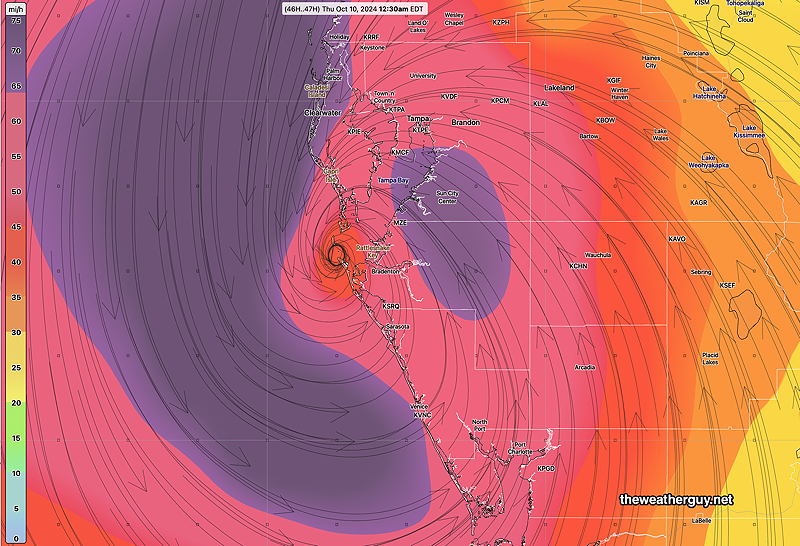
NOAA’s newest hurricane model, the HAFS B has an earlier landfall further north near Tampa Bay—
12z HAFS B forecast for midnight Wednesday into Thursday morning. (Click on image for a larger view.)
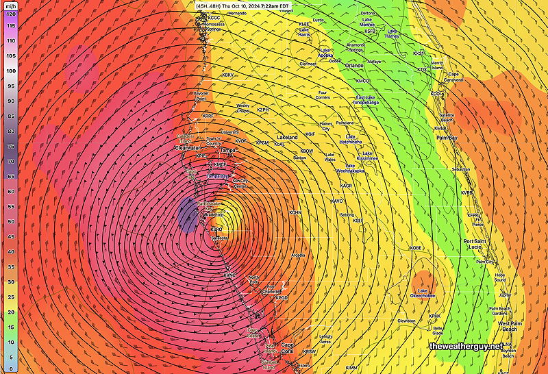
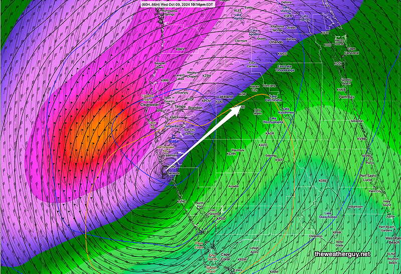
Posted Tuesday 10/08/24 @ 3:00 PM — Today’s models have trended towards a somewhat later landfall for Milton, sometime in the early morning hours of Thursday.
Here’s NOAA’s high resolution Hurricane model, the HWRF, one of several NOAA hurricane-specific models—
Todays 12z HWRF model wind speed and surface pressure forecast at 5 AM. Notice the northward track of this model. with landfall north of Clearwater. (Click on image for a larger view.)
There’s still a range of landfall predictions and there’s no reason to believe this is the correct one.
Posted Tuesday 10/08/24 @ 10:41 AM — The latest ECMWF-AIFS model shows Hurricane Milton reaching landfall just before midnight Wednesday into Thursday near Sarasota. This AI model has been extremely consistent in forecasting this storm and consistent about its track.
10-08-24 06z ECMWF-AIFS forecast for Thursday at 12:01 AM. Rainfall shading (Click on image for a larger view.)
In contrast, the GFS is slightly north, directly entering Tampa Bay—
10-08-24 06z GFS Winds at 12:28 AM Thursday. Slightly north of the ECMWF-AIFS, forecast track, entering Tampa Bay. (Click on image for a larger view.)
Hurricane Milton Update
Posted Monday 10/07/24 @ 5:20 PM —The latest ECMWF-AIFS has become available. I’m leaning towards this model because it was the first to forecast this hurricane over a week ago and it did quite well with forecasting Helene’s track.
The latest ECMWF-AIFS takes the storm just north of Sarasota about 10 PM to midnight Wednesday—
10-07-24 12z ECMWF-AIFS forecast for 10 PM Wednesday evening. Shading is rainfall rate. (Click on image for a larger view.)
Note that our GFS model is significantly further north with Milton’s landfall and is somewhat slower, making landfall about 2 AM Thursday—
10-07-24 12z GFS has a track further north and somewhat slower, reaching landfall north of Clearwater at 2 AM Thursday. (Click on image for a larger view.)
The operational version of the ECMWF is closer to the GFS than it’s own AI version.
Just an acknowledgement that this is a dynamic situation, no single model should be relied upon and the official information from the National Hurricane Center should be utilized.
Quiet Here Weather-wise. And then there’s Milton
If I had some time off as a meteorologist in the northeast, this week would be a great time to take an extended vacation.
Fair weather and no significant rainfall for our area for at least a week!
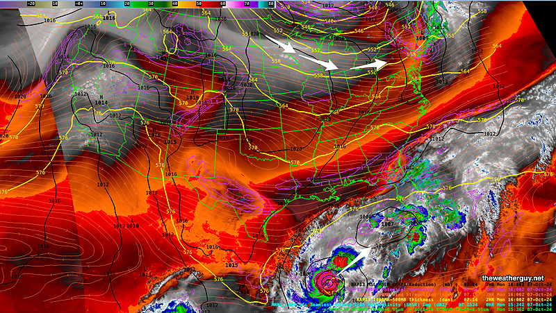
A very amplified high pressure ridge will fill the central and western US while the northeast will be under the influence of an upper trough—
Monday morning Water Vapor image with superimposed RAP model parameters. Upper trough over our area, strong blocking ridge over the central and western US. Hurricane Milton visible. (Click on image for a larger view.)
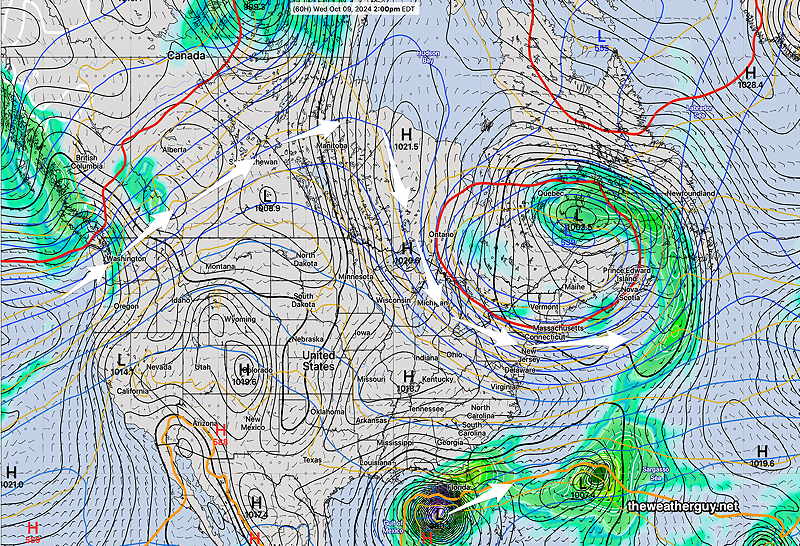
By Wednesday, the upper low closes off to our northeast and nothing but dry high pressure is available to affect our weather—
NAEFS forecast for Wednesday at 2 PM. Large ridge and high pressure to affect our weather. (Click on image for a larger view.)
Hurricane Milton
The ECMWF AIFS had successfully predicted the formation and likely track of what is now known as Hurricane Milton well over a week ago. It did this long before the regular models showed any specific development. It also was very successful with the general track of Helene.
The ECMWF-AIFS latest run shows the following possible landfall between 8 PM Wednesday and 1 AM Thursday—
10-07-24 06z ECMWF-AIFS forecast for Hurricane Milton at 8 PM. Milton shows signs of weakening somewhat as it approaches south of Tampa Bay. (Click on image for a larger view.)