This Labor Day Weekend and even the days following would be a good stretch for meteorologists in the Northeastern and Mid-Atlantic to take a vacation. There’s not much happening, as a large, sprawling high pressure system will be with us at least through next Wednesday.
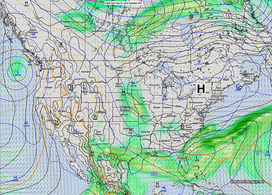
12zECMWF-AI forecast for Monday at 2 PM. High pressure in control. (Click on image for a larger view.)
Expect continued dry conditions, low humidity and sunshine!
Next Thursday into Friday, a strong cold front will likely bring some much-needed rainfall to our area, although precipitation amounts look to be modest. Even more Fall-like temperatures for the next weekend.
Saturday Forecast
Sunny and pleasant.
NBM high temperatures: Blue Bell, PA 74º Philadelphia, PA 75º Low Uncertainty (based on standard deviation): ±0.7º
Sunday Forecast
Continued sunny and pleasant. High cirrus clouds during the afternoon may dim the sunshine a bit as winds switch to the southwest and moisture moves in aloft.
NBM high temperatures: Blue Bell, PA 78º Philadelphia, PA 79º Very Low Uncertainty (based on standard deviation): ± 0.9º
Monday Forecast
Sunny and a bit warmer.
NBM high temperatures: Blue Bell, PA 79º Philadelphia, PA 80º Low Uncertainty (based on standard deviation): ± 1.1º
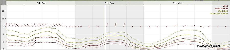
Winds will be light to breezy.
18z NBM Wind meteogram for Blue Bell, PA (Click on image for a larger view.)
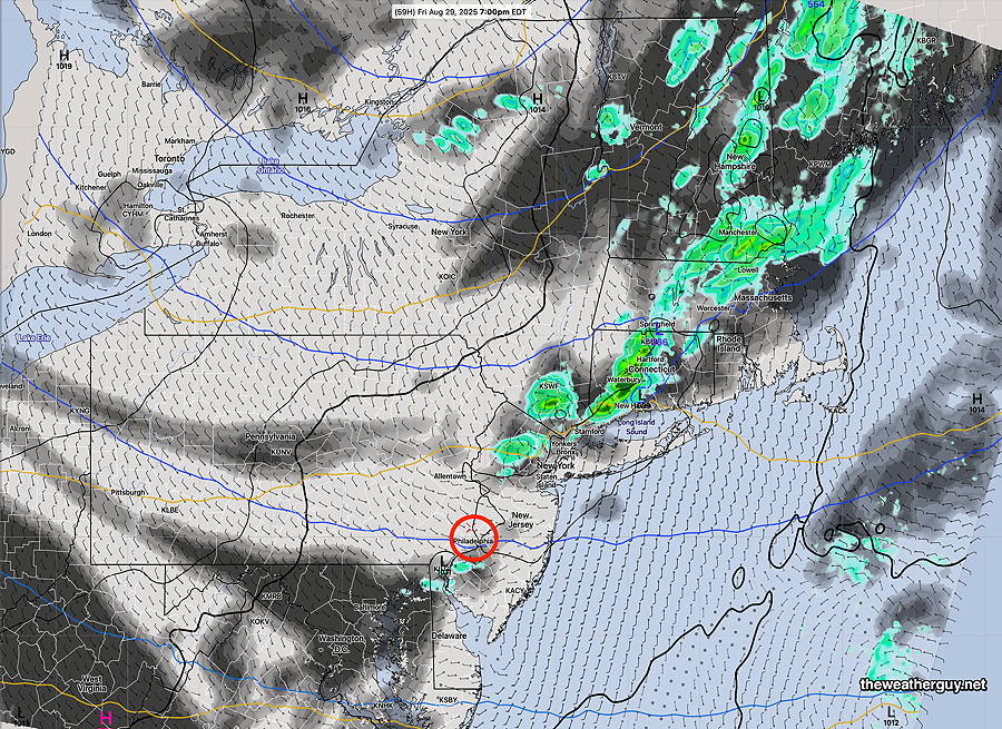
Posted Thursday 08/28/25 @ 5:09 PM — The clouds came in today as forecast yesterday. I could be wrong, but I didn’t hear much about this cloudiness last night from the TV/radio weather folks.
The forecast for Friday is looking better. Little in the way of clouds and the chance of a shower late afternoon is very low.
The weekend weather looks quite spectacular! Enjoy!
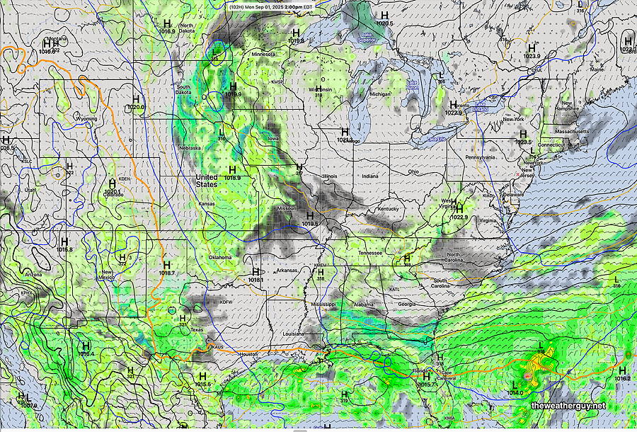
12z GDPS with “AI Spectral Nudging” forecast for Monday at 2 PM. High pressure over the northeastern US. (Click on image for a larger view.)
Thursday Friday Outlook
Posted Wednesday 08/27/25 @ 5:27 PM — High pressure moves off to the east. A return southwesterly flow of somewhat moister air moves in aloft bringing some mid-level cloudiness mid morning Thursday until about 3 or 4 PM Thursday afternoon.
A cold front moves through Friday morning. The upper air dynamics are well well north of our region. With little moisture, we may get some clouds, but even that looks to be negligible. Wind shift back to the west northwest to continue our spectacular weather.
A few instability showers may develop late afternoon; most areas will see no rainfall.
12z RRFS forecast for Friday 7 PM. (Clouds-black grey) The cold front brings little in the way of rain to our area. (Click on image for a larger view.)
Tuesday Update
Wed 5:00 PM —Forecast Review — As a followup to yesterday’s informal test of the RRFS, isolated showers did break out and made it into western Chester, Montgomery and Bucks counties before dissipating.
Yesterday’s Radar loop courtesy of WeatherTap.com. A reasonable likeness to the 12 RRFS forecast. A later (18z) RRFS forecast was spot-on. (Click on image for a larger view.)
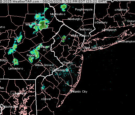
Posted Tuesday 08/26/25 @ 4:17 PM — Not much happening weather-wise this week. But another quick test presents itself this evening for the RRFS experimental model . The RRFS shows a potent short wave moving through our area with enough moisture and vertical lift to cause a few very widely scattered showers Tuesday evening, about 9 PM.
12z RRFS model Relative Humidity at 10,000 feet (maroon shading) and areas of strong vertical motion (multicolor shading). (Click on image for a larger view.)
Just curious to see if it happens.
FYI, a similar setup about 7-8PM up in New York for the Phillies. Too widely scattered to likely affect the game.
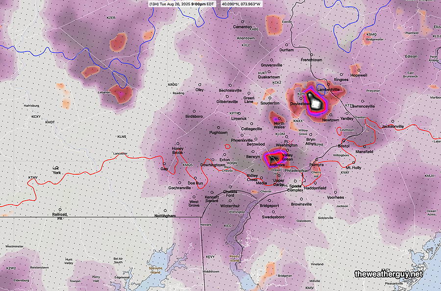
Originally Posted Mon 9:57 AM —What appears to be a changed weather pattern has taken hold with an upper level trough in the eastern US with surface level high pressure. A mostly dry and cooler pattern will result.
06z ECMWF-AI forecast for Thursday at 8 AM. High pressure over our area. A cold front near the Great Lakes may bring light showers later Friday, but a mostly dry and cool pattern overall. (Click on image for a larger view.)
Mon 10:00 AM —Forecast Review — Last evening’s late posting showed major differences in forecasting between the HRRR & NAM-NEST model forecasts and the new, soon to be released (I hope), RRFS experimental model. (RRFS– Rapid Refresh Forecast System, an hourly updated model with the 00z 06z 12z and 18z runs forecasting out to 84 hours.)
The RRFS, at least in last night’s situation, demonstrated a superior forecast to the existing older models.
No specific release date has been made for the RRFS and its ensemble version, the REFS, but early 2026 is a good bet.
The NWS has already solicited comments regarding planned discontinuation of several older models including the SREF and the HRESW models. Likely to be included in the discontinued list will be the NAM.
The RRFS and the REFS have clearly been developed to replace the functionality of the older models. I’ve been using the RRFS experimental version as my principal model over many months now and the RRFS appears to be, overall, an improvement in forecasting.
Showers early Monday morning?
Posted Sunday 08/24/25 @ 11:20 PM — An interesting setup for early Monday morning. The 00z NAM-NEST and 00z HRRR show a broken line of showers and possibly thunderstorms moving through about 5AM -6 AM. The experimental 00z RRFS shows almost nothing. It will be interesting to see what happens.
Sunday Update
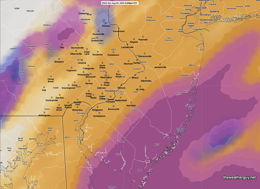
Posted Saturday 08/23/25 @ 9:13 PM — Sunday looks to be dry. All models show the line of showers that moves to our west will fall apart. A few sprinkles are possible from this same system before daybreak Monday.
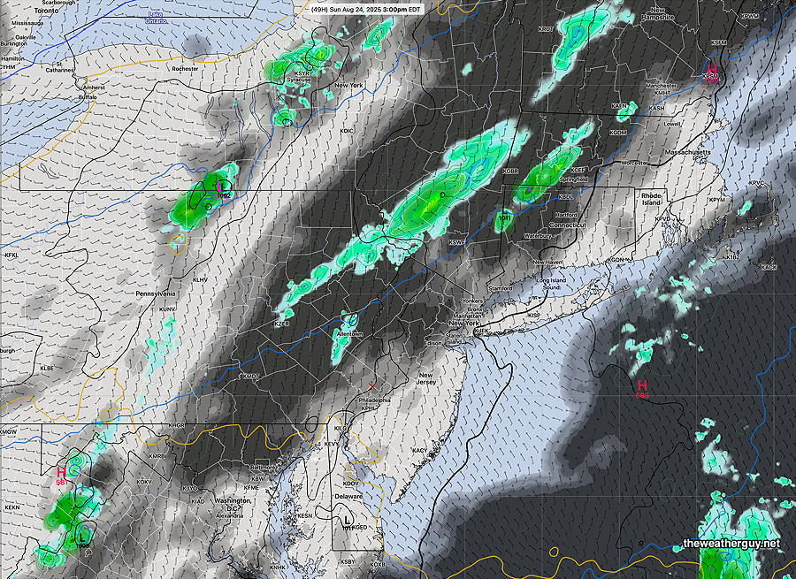
Also on Sunday, a weak system in the western Atlantic will bring some clouds to NJ, both in the morning and again the mid afternoon Sunday. The Philadelphia area will see a very thick layer of cirrus clouds, but dimmed sunshine should be able to pass through.
18z RRFS model forecast for 3 PM Sunday. Thick layer of high clouds (tan) around the city. Dimmed sunshine. More cloudiness at the shore (mid level clouds- maroon) at the shore. (Click on image for a larger view.)
The coming week looks dry. No systems expected to bring any rain. So we’re in another dry spell.
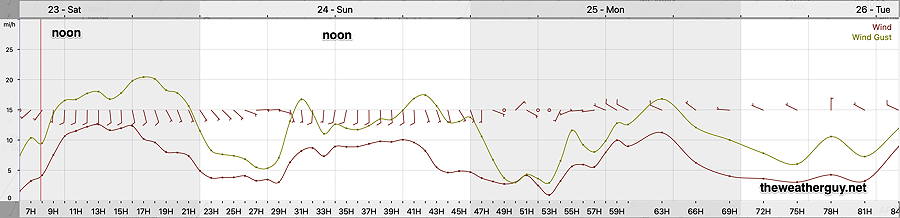
Posted Saturday 08/23/25 @ 9:58 AM —The latest model guidance shows it being a bit more windy today (Saturday) than previously forecast. Otherwise, beautiful.
Here’s the wind meteogram for Blue Bell, PA—
06z RRFS forecast wind speed/gusts for grid point Blue Bell, PA Saturday through Monday. Gusty winds towards evening from the south, then southeast. (Click on image for a larger view.)
Originally Posted Fri 9:56 PM —The beautiful weather will continue through early Sunday. High pressure maintains its hold through Saturday, but a southeasterly flow from a newly formed weak coastal low and a front to our northwest that loses its upper air support will bring a bit more humidity and some cloudiness for Sunday afternoon and evening. (The shore stays sunny, according to the RRFS.)
18z RRFS clouds/precip at 3 PM Sunday. Approaching front falls apart due to wide, diffuse and split jet streak aloft. (Click on image for a larger view.)
Showers originally expected for Sunday afternoon will likely fall apart as they approach Philadelphia due to a diffuse, broken jet streak.
Saturday Forecast
Sunny and quite nice. High 84° Blue Bell, 83°Philadelphia (not a typo)
Sunday Forecast
Somewhat increased humidity, but dew points still in the low 60s. High thin clouds in the morning lower to mid level clouds in the afternoon. No showers expected until later in the evening. Most areas may receive little or no rain; any rain will be light.
NBM high temperatures: Blue Bell, PA 84º Philadelphia, PA 83º Uncertainty (based on standard deviation): ±1.4º