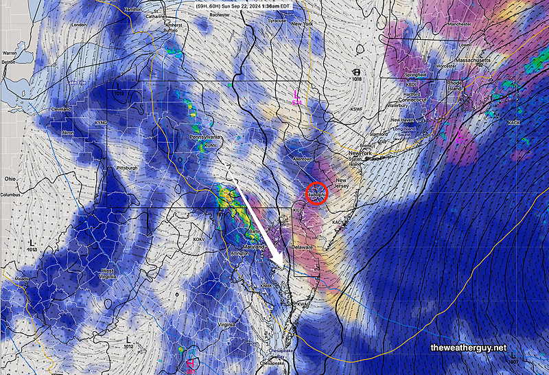
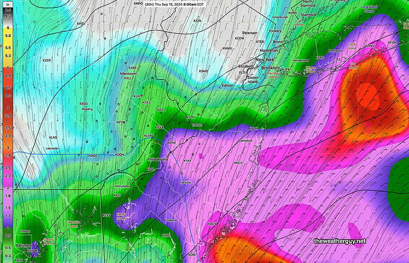
Posted Friday 09/20/24 @ 9:26 AM — The latest GFS still has showers moving into Philadelphia Saturdaynight, (possibly) breaking a pattern that has kept showers to our west. Embedded thundershowers also possible.
GFS has narrow area of showers/thundershowers sliding down from the northwest (white arrows) after midnight. (Click on image for a larger view.)
Saturday— Mostly sunny, showers/thundershowers after midnight.
Sunday— Clouds break for sunshine by the early afternoon. Cooler.
Friday’s Weather and Weekend Outlook
Updated Thu, 09/19/24 @ 7:30 PM— Based on the latest GFS, just available, it looks like the showers will reach the Philadelphia area Saturday night and clouds will linger into Sunday. I’ve changed the Sunday forecast below.
Posted Thursday 09/19/24 @ 5:29 PM — High pressure continues to nose down into our area, keeping the storm in the western Atlantic off to our east. Friday will be mostly sunny and quite nice. Highs 82º to 83º
Saturday will also be sunny a bit cooler, with some occasional cloudiness, especially later in the day. Highs 79º to 82º.
Sunday—
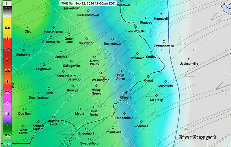
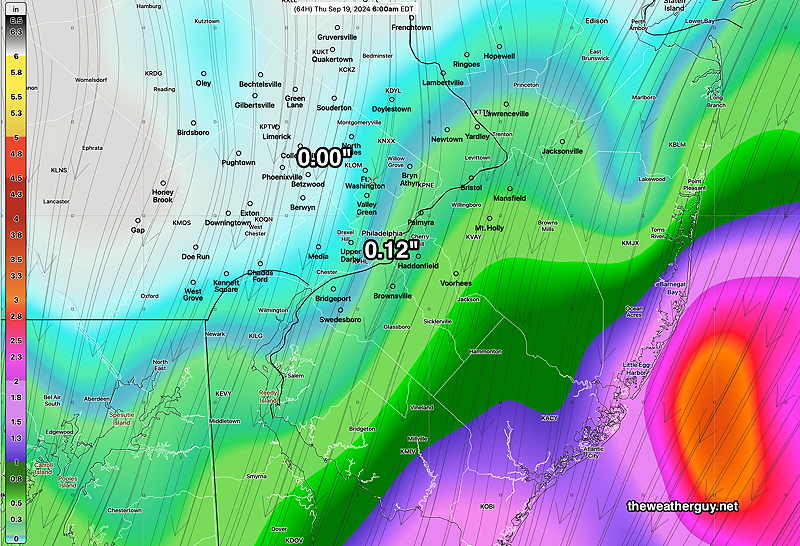
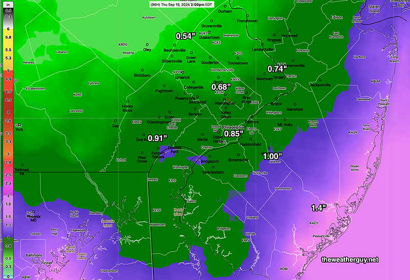
NAM-NEST forecast for Saturday night. Showers stay to our west, blocked by high pressure. (Click on image for a larger view.)GFS total rainfall by Sunday morning. Showers make it into Philadelphia, then fall apart. (Click on image for larger view.)
A disturbance approaches us late Saturday into Sunday from the west. While the NAM-NEST above keeps the showers to our west, the latest 18z GFS has showers moving into Philadelphia after midnight Saturday with clouds lingering into Sunday. The showers weaken as they move through. Cooler air moves in behind this disturbance
Cloudiness lingering with light sprinkles in the morning on Sunday, possibly some breaks of sun late. Cool northeasterly flow. Highs near 74º
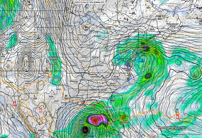
Active Week next week — Following this current tranquil weather, things get interesting next week. A coastal system is possible and another hurricane, possibly significant, is also looking likely.
GFS forecast for next Friday, 9/27. A coastal system and another Gulf of Mexico hurricane. (Click on image for a larger view.)
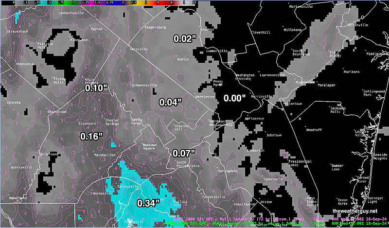
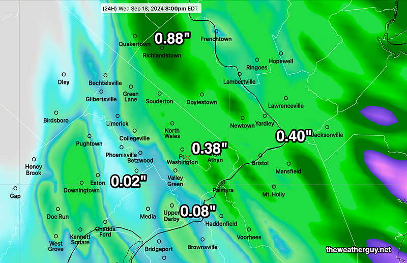
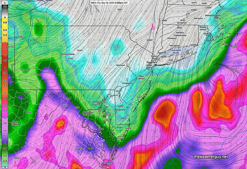
Rainfall Totals
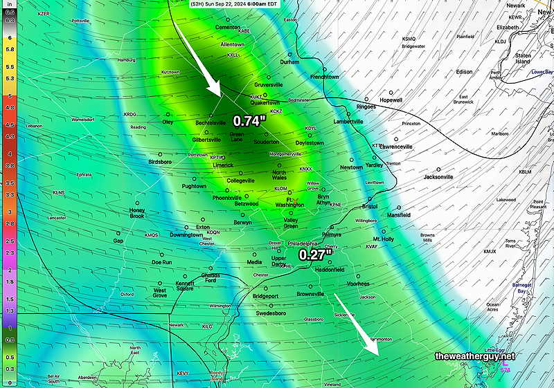
So how much rain did we get these past two days?
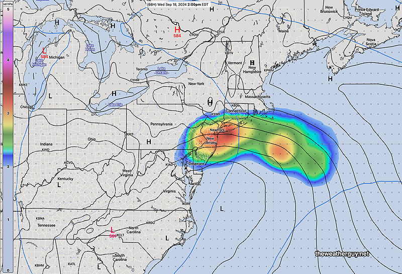
MRMS rain-gauge measured rainfall combined with rain-gauge calibrated/interpolated radar-based summary of ACTUAL RAINFALL RECEIVED. Color shading is in inches. Line contour numbers are in mm. (25.4 mm= 1 inch) (Click on image for a larger view.)
There’s not much chance of rain again until sometime the end of next week. Also on the horizon, another hurricane is expected to form somewhere in the Gulf of Mexico next Wednesday or Thursday.
Posted Wednesday 09/18/24 @ 4:47 PM — It’s a good thing every weather system isn’t like this one; I’d have to find another avocation.
Forecast Review —One thing to point out— the ECMWF, often touted to be ‘best model’, really led me astray this week. I think my recent exploration of the AI version of the ECMWF has caused me to put too much emphasis on the ECMWF and the ECMWF-AIFS forecasts . I plan to let this fascination with these models pass for future forecasts.
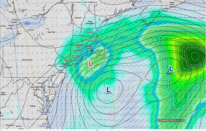
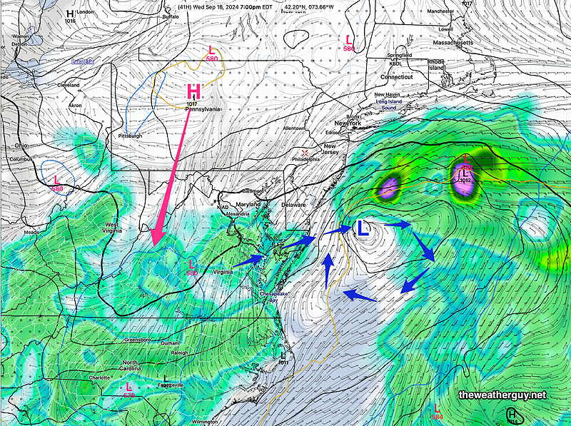
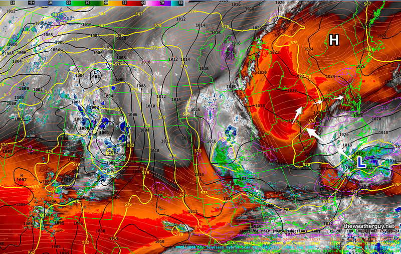
The current setup is complex to model, with two centers of low pressure and and upper level low off the coast—
NAEFS model statistical “mode” version with overlayed GEFS model “bias-corrected” precipitation forecast for Friday. Upper low (RED L) and surface lows (Blue L) The two lows will rotate around each other, transferring energy and momentum, much as two ice skaters moving with each other. (Click on image for a larger view.)
We’re likely not to get much more rainfall in this area tonight. Some light showers are possible with an easterly flow.
Most models continue to keep us dry and are forecasting mostly sunny skies for Thursday and Friday. The exception will be east into coastal NJ, where more clouds and even some showers are possible each day. That said, the double low system with closed upper low will continue to create low confidence forecasts.
Difficult Forecast
Posted Wednesday 09/18/24 @ 10:19 AM — This weather system continues to be a very difficult one to forecast. Case in point is the HRRR which seemed to be capturing the forecast well last night.
Well, this morning’s 12z HRRR current radar simulation shows no relationship to the reality of current radar—
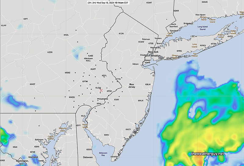
HRRR forecast radar—
12z HRRR simulated radar at 10:14 AM (Click on image for a larger view.)
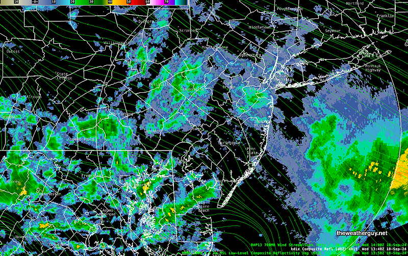
Current Radar—
Current radar at 9:48 AM (Click on image for a larger view.)
Clearly a huge difference! So which model can we hang our hat on? Very difficult call, but the ECMWF has probably been closest to reality, despite big swings in its forecast rainfall. (Frankly, none of the models have been very good.)
The ECMWF shows rain redeveloping later today into tonight. And it once again shows some significant rainfall for some of the immediate PHL area.
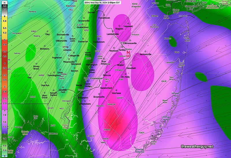
Here’s the latest 06z ECMWF and its 30 hour rainfall forecast through 8AM Thursday—
09-18-24 06z ECMWF forecast 30 hour precip through 8 AM Thursday. (Click on image for a larger view.)
Posted Tuesday 09/17/24 @ 10:23 PM — The 00z HRRR 24-48 hour forecast shows additional rainfall here on Thursday. So rainfall may be more substantial than previously thought. Forecasting this potential rainfall has been a trial and an ordeal.
Posted Tuesday 09/17/24 @ 9:44 PM —Yet another rain forecast with the latest HRRR model just available.
Light showers in the early morning Wednesday. More showers after 3 PM into the evening and night time hours.
The HRRR is the most inline with the tonight’s model blend (NBM) and the latest experimental RRFS. It’s also in range with the latest ECMWF. Here’s the accumulated rain through 8 PM Wednesday—
09-17-24 00z HRRR 24 hour accumulated rain forecast for Wednesday. Additional rain possible after 8 PM, so this is a partial forecast. (Click on image for larger view.)
Huge Forecast Change?
Tue 06:02 PM Update — The NAM-Nest still has the storm further away off the coastline and continues with little rain for us. The latest Canadian RGEM keeps the rain away and off the coast. The HRRR also has almost no rain here. The AI version of the ECMWF has only light rain here. It looks like forecast of the ECMWF posted at 4:56 PM with the heavy rain is an outlier.
Here’s the latest GFS 30 hour forecast—
18z 09-17-24 GFS forecast accumulated rain through 30 hours -8 PM Wednesday. Rain misses our area. (Click on image for a larger view.)
Posted Tuesday 09/17/24 @ 4:56 PM — It’s been clear that this week’s weather would be low confidence/high uncertainty. The latest ECMWF has just come in and it has a huge change in the forecast. I wanted to get this posted; many other models have not yet become available and I’d like to compare it with the latest GFS, which won’t be available until around 6 PM.
The latest ECMWF completely changes its forecast. The coastal low, expected to be off the coast is now forecast to be right on the coast. Rainfall totals over 3 inches are now forecast by Thursday!
12z 09-17-24 ECMWF total rainfall forecast by Thursday morning. (Click on image for a larger view.)
I’ll be reviewing other models and will update this forecast early this evening.
This Storm will Bypass our Area
Posted Tuesday 09/17/24 @ 9:23 AM — As has been the trend over several days, the main area of rainfall from the remnants of the tropical system will bypass the Philadelphia area, and a second low pressure system develops somewhere off of the NJ coastline.
The reason for the storm missing us— high pressure is expected to nose down in western PA and block its movement towards us.
The latest GFS has almost no rain in Philadelphia through Thursday, while the ECMWF and several other models show as little as 0.10 to 0.20″ .
The latest forecast models not only block the movement of the storm towards us, but they also block the exit of the storm from the western Atlantic. As a result, the storm is forecast to rotate and meander around itself off of the NJ Coast for several days.
The caption on the graphic below explains the situation—
06z GFS forecast for Wednesday evening. Low pressure off the Delmarva coast will rotate around itself and meander through Friday. It is forecast to retrograde back towards the coast. Meanwhile, high pressure over western NY and Pennsylvania will nose down into Virginia, blocking the rain shield from our area. (Click on image for a larger view.)
With a meandering system rotating around itself, uncertainty with this forecast is high regarding the location of the low.
The ECMWF shows high uncertainty in the position—
00z ECMWF ensemble surface pressure standard deviation. Uncertain position of the low late Thursday. (Click on image for a larger view.)
With uncertainty in the position of the low, any forecast through Friday has lower than usual confidence.
Posted Monday 09/16/24 @ 6:19 PM — The forecast track for this storm has changed and a secondary low is forecast to develop somewhere off the coast. The latest GFS reverts back to a minimal rain event for our area—
18z 09-16-24 GFS total rainfall (Click on image for a larger view.)
The latest ECMWF is somewhat similar. Some of the higher resolution models have about 0.40 to” 0.70″ of rain (RGEM, NAM-NEST, HREF)
The good old NAM still is forecasting heavy rain here, likely not correct—
09-16-24 18z NAM model total rainfall forecast (Click on image for a larger view.)
Still an uncertain forecast with lack of consistency. Stay tuned.
Posted Monday 09/16/24 @ 8:36 AM — The storm track of Tropical Cyclone 8 (not yet named a tropical storm) has changed and slowed somewhat from yesterday, according the the National Hurricane Center. As a result, the forecast for our area remains uncertain.
The “ensemble” models statistically capture uncertainty as an increase in standard deviation of their model members. The latest ECMWF ensemble shows high uncertainty in the position and track of the expected extra-tropical low on Wednesday.
While several models still maintain our area in a precipitation ‘hole’, the latest GFS has shifted some of the heavy rainfall back into our area—
06z GFS total rainfall by Wednesday 2 PM (Click on image for a larger view.)
Further changes are expected. Stay tuned!
Posted Sunday 09/15/24 @ 7:17 PM —The latest GFS has become available and the trend is for much less rainfall here. In fact, for much of our area, the GFS has almost no rainfall this week.
I heard the 6 PM forecast on TV, however, I don’t see “flooding rains” in the immediate Philadelphia area. (The TV weather people are big ECMWF model fans, which is still predicting somewhat heavy rainfall here.)
18z GFS forecast rainfall through Thursday 2 PM. (Click on image for a larger view.)
When it comes to tropical systems, forecasts often change. Stay tuned.
Originally Posted Sun 5:42 PM —It’s been many weeks since any substantial rain has fallen here. The tropical system off the North Carolina coast (Tropical Cyclone Eight) had been expected to bring us much needed heavy rainfall, however, recent trends, as discussed in this past Weekend Weather, show the rainfall forecast in the immediate Philadelphia area to fall short of what’s needed.
Here’s the current water vapor image—
Current satellite water vapor image with superimposed RAP model 500-1000 mb thickness lines (yellow), Mean Sea Level Pressure isobars (black contours) potential vorticity (fine violet contours) with superimposed MRMS RADAR. Based on the models, I’ve drawn the approximate track of this storm. The storm is blocked from northward movement by persistent high pressure. (Click on image for a larger view.)
There remains a range of rainfall totals, with each model having a somewhat different take on things.
The latest model blend (NBM) captures the trend, with the heaviest precipitation bypassing the immediate Philadelphia area—
18z NBM forecast total rainfall through Thursday at 2 PM. (Click on image for a larger view.)
The time frame of the storm is outside of the higher resolution model ranges at this time (60-84 hours). Changes in the forecast are still likely.