
#Philadelphia #weather #PAwx
Not a Drought Buster
Posted Thursday 09/05/24 @ 5:53 PM — Little change in the forecast for Friday and Saturday.
Friday will have clouds with some light drizzle or sprinkle early in the day as a warm front approaches.
Saturday will be cloudy with light sprinkles possible in the morning, showers move through with a cold front early Saturday afternoon, clearing early evening.
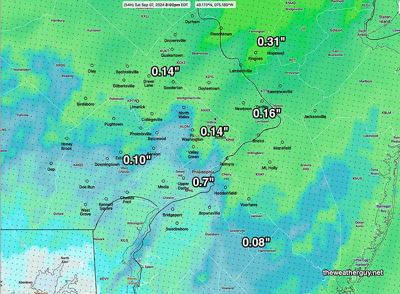
We need some rain and the total rainfall looks disappointing, with many areas coming with 0.20 inches or less of rain. The trend has been towards lower rainfall totals.
Here’s the model blend (NBM)—
Posted Wednesday 09/04/24 @ 8:57 PM — Latest models showing minimal rainfall for Saturday and a faster frontal passage
Posted Wednesday 09/04/24 @ 6:00 PM — One more day of incredible weather on Thursday.
Friday‘s weather is looking much less outstanding. Earlier this week, it looked like some clouds would move in with an easterly flow. Several model runs now show some light showers and possibly some drizzle by early afternoon on Friday with the easterly flow. This is especially true at the NJ Shore.
The rainfall expected on Saturday will not be a drought buster and may be a disappointment. A front moves through during the daytime Saturday with showers and even some thundershowers. Showers may start as early as mid to late morning and continue through the early evening.
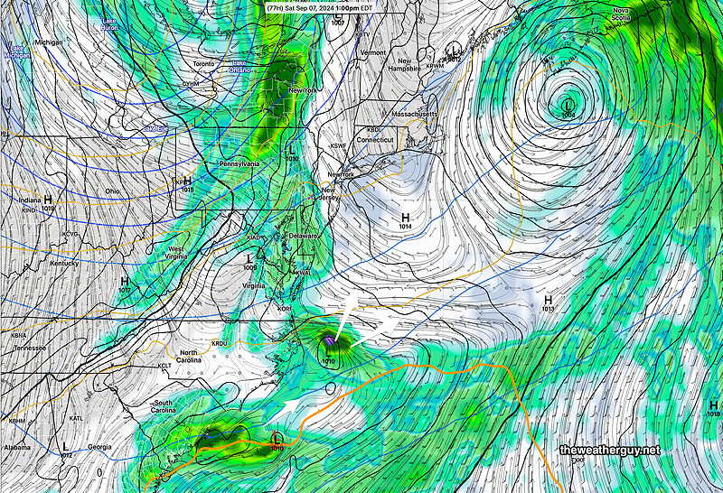
Depending upon the closeness of a low pressure system in the Atlantic, an unknown amount of moisture may be available for showers here on Saturday.
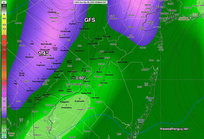
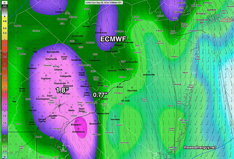
The ECMWF and ICON models have the low further away and the total precipitation here may only be about 0.2-0.3 inches. The GFS and Canadian GDPS have the Atlantic low closer to us, with more moisture available here. Amounts may range from 0.4″ to 0.6″.
The model blend (NBM) is showing the average, about 0.3″ rainfall. Not a drought buster.
Forecast Update
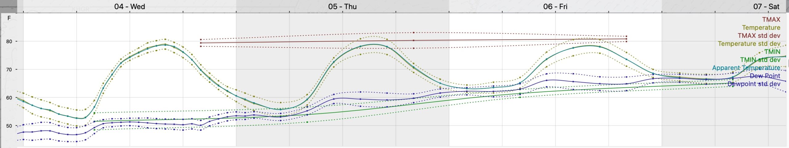
Posted Tuesday 09/03/24 @ 6:07 PM — Wednesday and Thursday continues to promise beautiful weather here in Philadelphia with gradually increasing temperatures approaching or exceeding 80º —
Clouds increase on Friday, but rain is currently expected to wait until Saturday, as an approaching cold front and moisture from a system in the expected to develop near the North Carolina coast that may take on some tropical characteristics.
Here’s the latest ECMWF- AI (machine learning) model forecast for 2 PM Saturday—
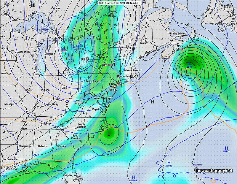
At this time, total rainfall in the Philadelphia area on Saturday will range from 0.40 to 0.50 inches. which is already trending lower from yesterday. The higher resolution models will provide better clarity with the areal coverage of the rainfall, but Saturday is currently beyond the forecast range of these models. Some thunderstorms are also expected on Saturday ahead of a cold front passage.
More Diminished Rainfall for Philadelphia
Posted Tuesday 09/03/24 @ 8:10 AM — I’m continuing with the thread about the current trend of rainfall diminishing as it approaches Philadelphia.
Our next chance of rain will be Saturday, with clouds on the increase Friday, possibly with some light showers east on Friday. Here’s the latest ECMWF and GFS forecast rainfall for Saturday, ending Saturday night.—
These numbers and areal coverage will certainly change by Saturday. The observation that the rainfall drops off towards Philadelphia isn’t by chance; there is a true mesoscale physical process at work, captured in the models, in the current weather pattern. This process is likely related to the points made in the boxed comment below.
I’ve been doing much reading behind the scenes to try to understand why the rain is dissipating in the immediate PHL area. I’ve seen this behavior over the years, during what I call “drought-like” times. Last time was the 2022.
One thing seems to be a anticyclonic curvature of the upper air winds and the development sort of a high pressure wall. Certainly true with the 576 thickness makes a curvature just east of Philadelphia.
The other thing is that Philadelphia is located just east of what they call the ‘fall line’ – the terrain altitude drops 200-300 feet from parts of upper Montgomery and Chester counties to the river. That drop in altitude seems to counteract any upward vertical motion needed for the rain to occur. By the time disturbance gets to the Delaware river, the terrain altitude is flat, so there is no other loss of vertical motion and whatever weak ‘forcing’ upward of air for rain can resume without being negated. So it skips over Philadelphia.
There is something called a local heat dome, with the “urban heat island” so warm that normal convection is inhibited right over the city.
Finally, there is a moisture feedback loop. Once soil moisture is depleted, you get into a dry begets dry situation that results in a dry feedback loop.
Any and all of these theories could explain what we’re seeing.
Originally Posted Mon @ 10:10 AM — —High pressure builds in and moves due eastward, giving us fair weather and comfortable temperatures/humidity Monday through Wednesday and possibly Thursday—
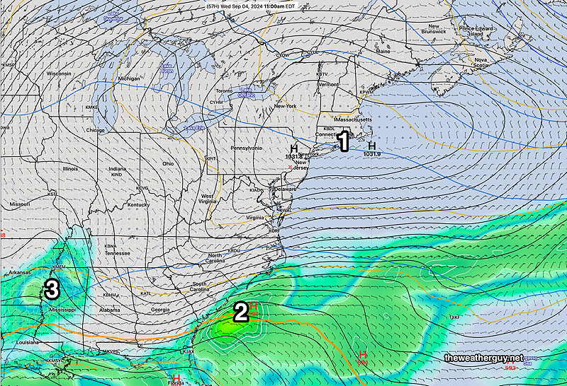
There is also potential tropical development in the Gulf of Mexico later this week, but it’s unclear if it will actually occur.