
#Philadelphia #weather #PAwx
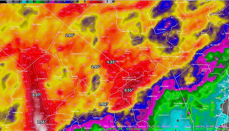
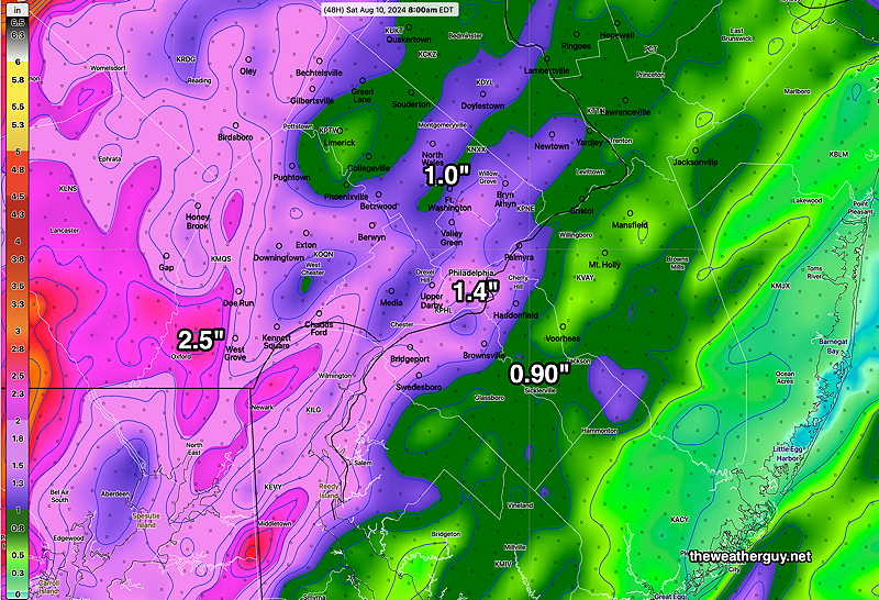
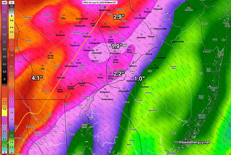
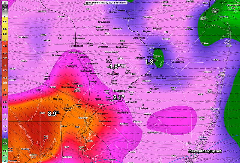
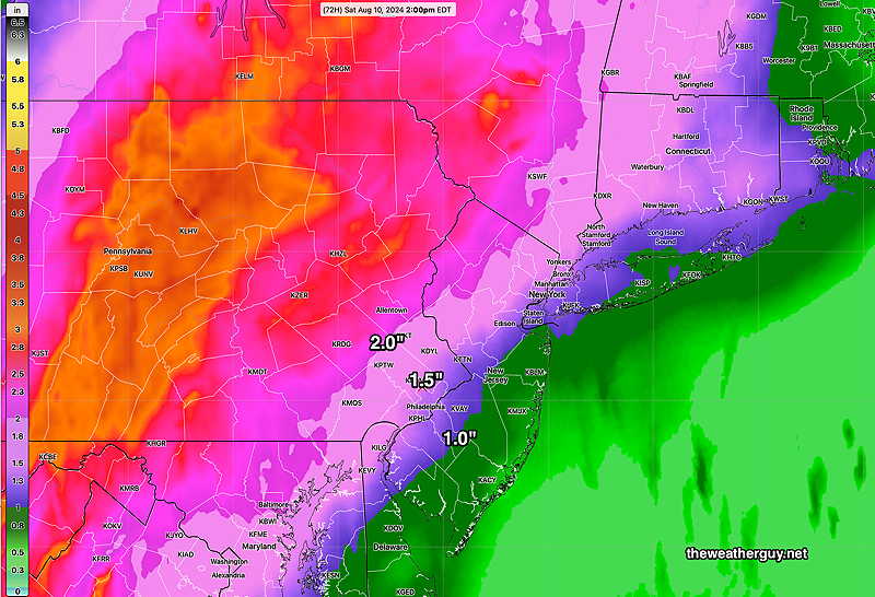
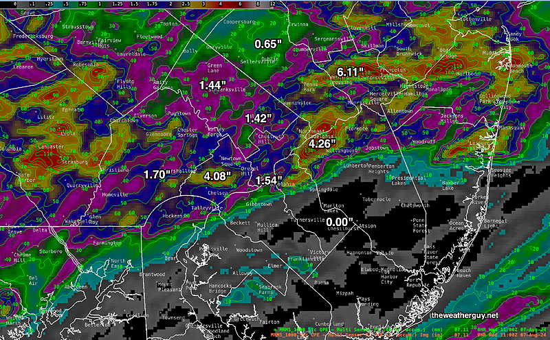
Rainfall Totals 72 hours
Here’s the latest MRMS past 72 hour rainfall summary —
Friday Storm Debby Update
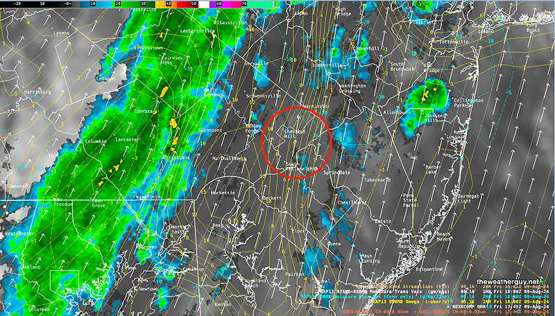
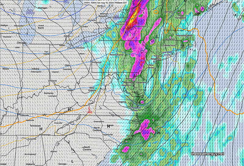
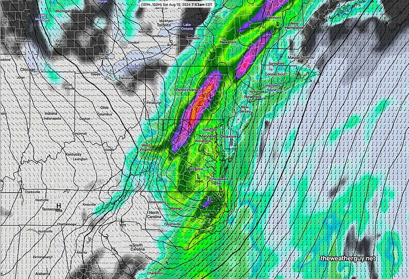
Posted Friday 08/09/24 @ 1:47 PM — The morning’s models are a bit too slow with the frontal movement; showers are currently just entering western Montgomery county and have already entered western Chester county.
The main line of showers and embedded thunderstorms will move through the immediate Philadelphia area around 3 PM to 4 PM.
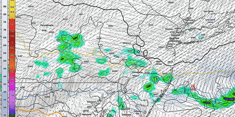
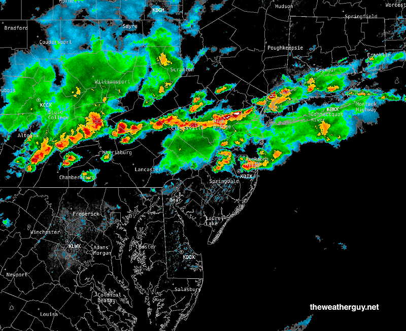
Radar/Water Vapor at 1:45 PM—
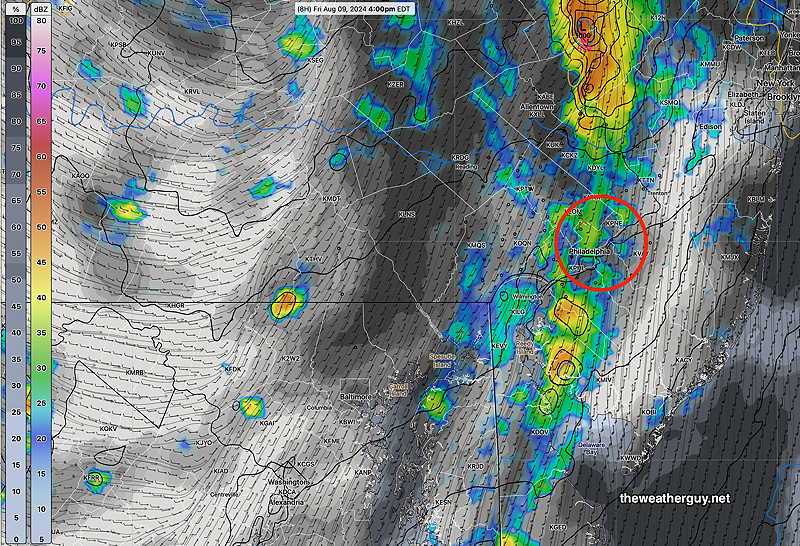
Experimental RRFS 12z forecast for 4 PM—
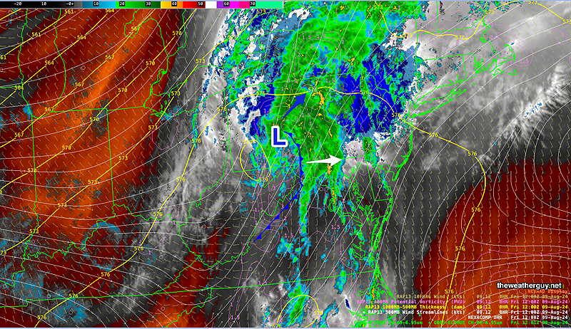
Posted Friday 08/09/24 @ 9:37 AM — The center of Debby is in west central Pennsylvania. An increasing pressure gradient will result in increasing wind gusts between now and 4 PM. Winds will gust 30-40 mph.
A cold front will move through this evening—
Thunderstorms should be breaking out ahead of this front from 4 -8 PM. Storms will be most numerous in western Bucks, Montco and Chester counties. An additional 1 inch of rain is possible with some of these storms as they move through Philadelphia between 4 and 8 PM.
Friday through Daybreak Saturday Update – Debby Remnants
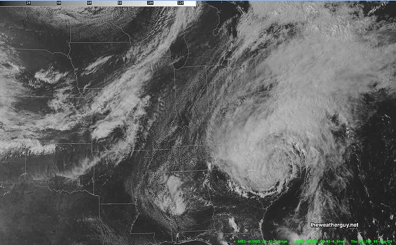
Posted Thursday 08/08/24 @ 5:22 PM — Some of the outflow moisture from Debby is already falling as rain here in the Philadelphia area. The storm center is still well to our south, but is expected to rapidly move northward and be well out of here by Saturday morning.
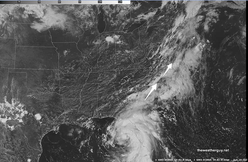
Here’s the current visible satellite image of Debby—
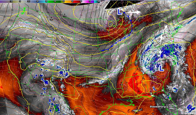
The water vapor image shows the tropical storm and the low pressure system that Debby is expected to merge with in Canada—
For Friday, rain heavy at times, with embedded thunderstorms possible in the afternoon and early evening hours. Rainfall is still in the 1.5″ to 4″ range, more westward. Locally heavier amounts are possible.
Precipitable Water Values (PWAT) are in the extremely tropical 2.6″ range.
Wind gusts 30-40 mph possible mid afternoon Friday into Friday evening.
The weekend looks real good!
Thursday through Daybreak Saturday Update – Debby Remnants
Posted Thursday 08/08/24 @ 11:53 AM — The forecast is little-changed from yesterday. The track of the tropical storm remnants will move though central Pennsylvania. A cold front moves through to sweep everything out by Saturday morning.
Today, Thursday, rain showers increasingly more widespread. Showers and thunderstorms for Friday, especially Friday afternoon and evening.
There are the usual range of model forecasts for rainfall, with no single forecast likely being truly accurate. Here’s the very latest HREF. Canadian RGEM, and ECMWF total rainfall by 8 AM Saturday—
HREF—
Canadian RGEM—
ECMWF—
A concern not previously discussed here are the strong wind gusts forecast, especially for mid to late afternoon Friday into the evening. Wind gusts may approach 40 mph.
Thursday through Daybreak Saturday – Debby Remnants
Posted Wednesday 08/07/24 @ 5:34 PM — As the remnants of tropical storm Debby approach our area, an increasingly moist flow will result in an increasing chance of showers through Thursday afternoon and Thursday evening.
As for the main low pressure system that are the remnants of Debby, it is expected to travel up through central or west central Pennsylvania Friday through Friday night.
The GFS model has it moving northward and being absorbed by low pressure in Canada. The ECMWF has it curving more eastward as it passes through Pennsylvania and New York State.
As a result, it appears that the heaviest rainfall will be in central PA and depending upon the curvature of the track, we’ll be on the periphery of the rainfall bands. The heaviest rainfall here will occur on Friday and Friday night. Additional thunderstorms, expected Friday late afternoon and evening, could affect local rainfall totals.
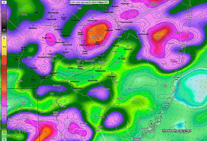
Nonetheless, 1″ to 2″ of rain is currently forecast from now until daybreak Saturday, a 72 hour period. The latest model blend (NBM) captures this—
As we see with most storms, predicting the actual locations and amounts of precipitation is more often than not incorrect. Additionally, should the low pressure system track more eastward, per the ECMWF model, I would expect greater rainfall here.
As I’m writing this, the latest Canadian RGEM has become available. It shows a more eastward track, with somewhat greater rainfall here.
Stay tuned.
Wednesday Forecast Update
Posted Wednesday 08/07/24 @ 8:50 AM — The area of rainfall has shifted to our south today. A few pop up showers possible late this morning through noon. Then any remaining activity will be mostly to our south. It will remain cloudy with an easterly wind.
For Thursday, additional scattered showers will move up from the south due to a moist flow from the approaching remnants of Debby. Showers will be scattered.
The rain more directly associated with Debby moves in to our area Friday. Rainfall will be scattered, especially east of the city.
It currently appears that the heaviest rainfall will be to our far west, due to a predicted westward track of this storm.
There’s still uncertainty in the track, speed and rainfall amounts from Debby as the westward track is current the current forecast, but with uncertainty on the eastward side—
Over recent years, this heavy rain phenomenon well in advance of a tropical system is referred to as a Predecessor Rain Event.
“Cote (2007) first defined the term predecessor rain event (PRE) to describe meso- and subsynoptic-scale regions of high-impact heavy rainfall that occur well in advance of recurving tropical cyclones (TCs) over the eastern third of the United States. PREs pose a difficult forecasting challenge because operational models can have difficulty properly representing mesoscale regions of heavy rainfall in space and time, and the mesoscale features that serve to focus the heavy precipitation can often be underanalyzed or missed altogether.” —Predecessor Rain Events ahead of Tropical Cyclones Thomas J. Galarneau Jr., Lance F. Bosart, and Russ S. Schumacher
Wednesday Outlook
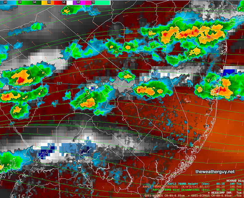
Posted Tuesday 08/06/24 @ 5:24 PM — At 5:30 PM, considerable thunderstorm activity has broken out north of the immediate Philadelphia area.
It’s unclear how far south this heavy rainfall will move towards the city. The latest HREF has some of it moving into our area over this evening and Wednesday morning. Here’s the total rainfall forecast by the HREF through the next 34 hours —
Most of the activity has developed near areas of strong horizontal moisture convergence, resulting in vertical motion.
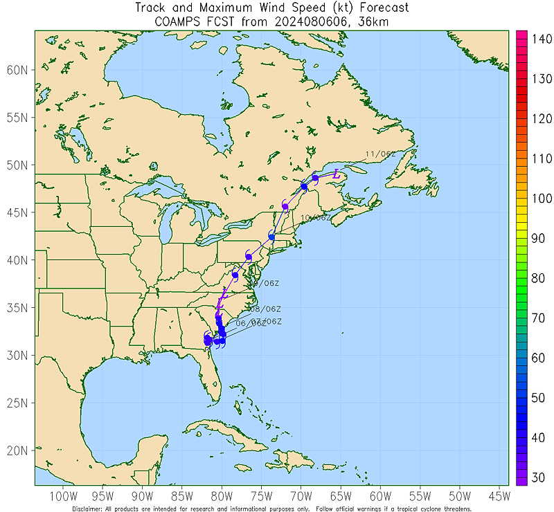
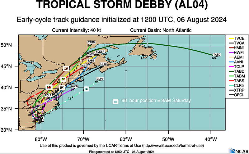
Tropical Storm Debby Update
Posted Tuesday 08/06/24 @ 10:20 AM — Additional track and timing information for Tropical Storm Debby —
Here’s the US Navy experimental COAMPS tropical model forecast —
Here’s a spaghetti plot of various specific hurricane models—
Tuesday and Wednesday Forecast Update
Posted Tuesday 08/06/24 @ 8:17 AM — A frontal boundary associated with low pressure moving to our north will slowly pass through Tuesday night. Before this, sunny skies with some wildfire smoke-related haze and high clouds will be our weather. The high resolution models are showing isolated showers and thundershowers as early as 2-3 PM in areas northeast of our area, primarily in Central NJ and northward.
Showers with the main frontal passage increase in likelihood after 9 PM this evening in our immediate area. The front hangs up south of us, leaving our area cloudy with some scattered showers on Wednesday.
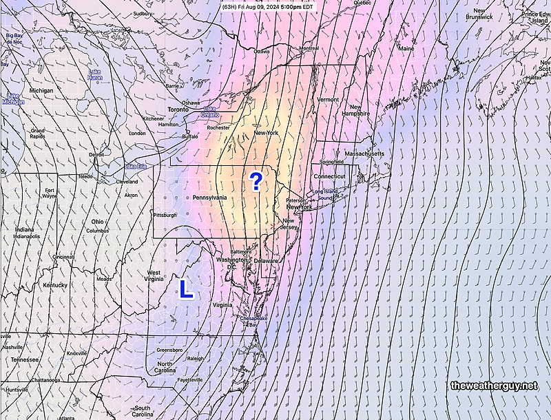
There remains some uncertainty with the track of the remnants of Debby. The GFS continues to forecast the storm moving westward into Georgia. The ECMWF, Canadian and German ICON have the remnants moving northward towards us . The forecasts come together by Saturday—
Tuesday and Debby Update
Posted Monday 08/05/24 @ 5:11 PM — A disturbance in the upper Midwest will move through our area bringing a frontal system that will switch our winds at the surface to easterly, cooling us down. Meanwhile, Hurricane Debby will downgrade to a tropical storm, but its track is very uncertain. It may linger, restrengthen, or retrograde westward into Georgia.
Here’s the current water vapor image showing both systems—
Tuesday will have sunshine through high cirrus cloudiness; an increase in lower level cloudiness will likely wait until the evening. There is the possibility of some isolated showers, mostly far north of our area starting around 4 PM. Heavier rain and thunderstorms will likely wait until 10 PM or later. Rainfall will be heavy overnight in some areas, mostly from the city northward. High temperatures 91-93º. Humid with dew points in the upper 60s to low 70s!
Wednesday looks to be cloudy and showery as the front hangs up just to our south. Cooler but humid and damp.
The possible model tracks of Debby couldn’t be more divergent, with the GFS keeping the storm in Georgia, while the ECMWF forecasts the storm to be directly over us late Friday night. As far-fetched as the GFS forecast is, I wouldn’t count it out; the GFS was the first to predict Debby and has been reasonably accurate to this point. Stay tuned.
Forecast Update
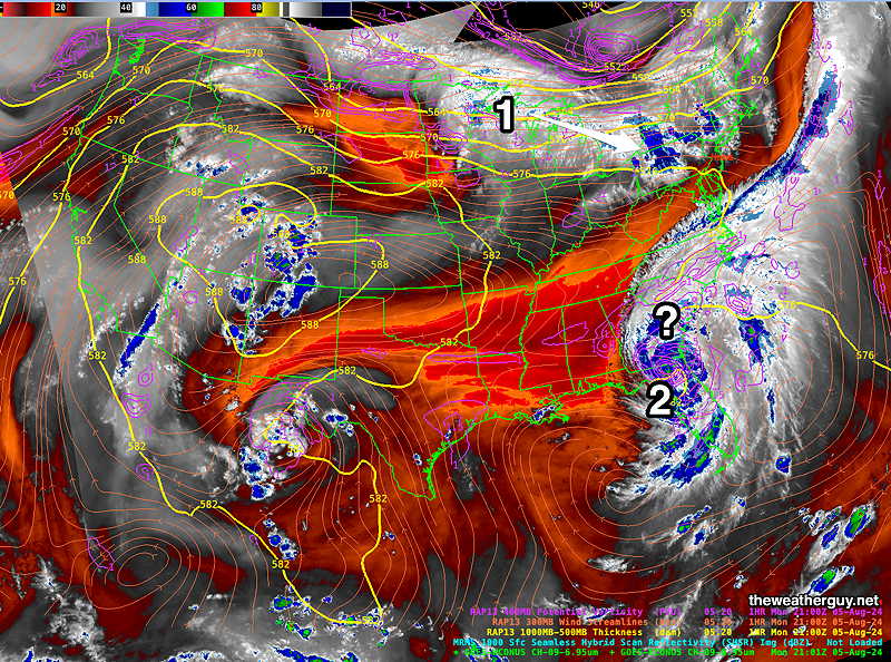
Posted Monday 08/05/24 @ 7:33 AM — Our weather will be influenced by two systems this week: ( 1) a low riding across the top of the heat dome ridge and (2) the remnants of tropical storm/hurricane Debby. Moisture, rain and humidity will be prominent this week. This week promises to be an ‘interesting week’, weather-wise.
Here’s the current forecast map (German ICON model) for early morning Tuesday —
Following a hot and somewhat humid day Monday with highs 93º-94º, a transitional day, Tuesday, will still have highs around 91º before clouds and thunderstorms move in.
For Tuesday, low pressure (1) will sink south and will bring a cooler but still humid flow behind it. Significant moisture and instability will result in heavy thunderstorms late Tuesday afternoon into Tuesday evening. Some models are showing several inches of rain with this system.
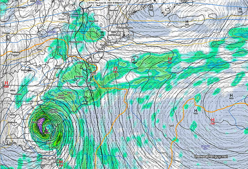
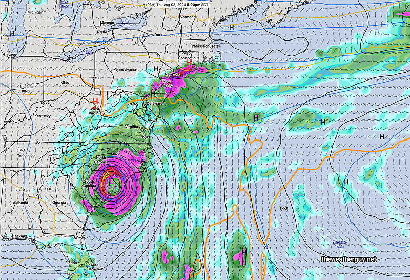
There remains uncertainty with the timing and track of the remnants of Debbie’ Here’s the GFS and ECMWF forecasts side by side at 5 PM Thursday—
 |  |
Originally Posted Sun 7:54 PM —This week’s weather around Philadelphia will be influenced by the track of the remains of tropical storm/Hurricane Debby and impulses riding along the jet stream and above the heat dome, near the northern US border.
Monday will feature a rest from the extreme heat and humidity, but it will still be hot here, with temperatures in the low 90s. Dew points near 70º in the morning will fall into the upper 60s during the afternoon peak temperature which will be a bit more comfortable.
A disturbance in the northern Midwest will move over our area later Tuesday with showers and thundershowers.
Uncertainty in the timing and track of the tropical storm’s remnants will impact any forecast for later this week.
Much uncertainty exists for this storm. Here are the current model tracks for Debby—
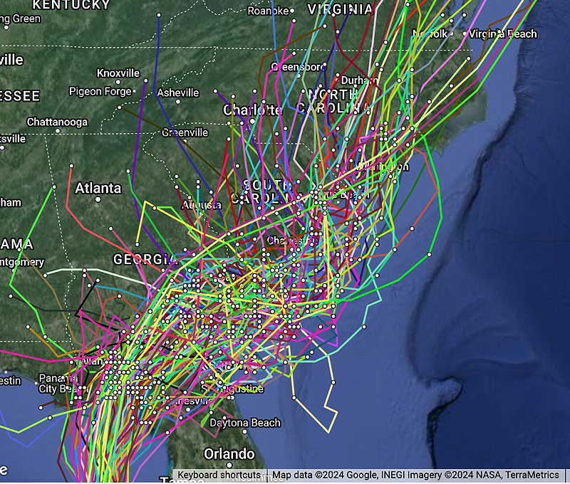
Significant uncertainty exists with later tracks. The ECMWF has the remnants eventually moving up towards us later in the week. The latest GFS has the storm retrograding into Georgia and lingering.
One more thing. I’ve always noticed that when a tropical system is in the mix, local model forecasts become less reliable. I’m not sure why, but I’ve seen it many times. Something to keep in mind with this week’s forecasts.