THIS WEEK’S WEATHER

#Philadelphia #weather #PAwx

Some Sunshine on Friday

Posted Thursday 12/28 @ 5:41 PM — It appears that things will clear out enough on Friday that we’ll see some sun. Indeed, a fair amount of sunshine is expected on Friday. (Yes, this is a change in the forecast from yesterday, where clouds were going to remain.)

The upper trough moves over us on Saturday with a reappearance of clouds, at least for a part of the day—

Today’s 18z GFS shows upper trough line (blue line drawn) and the clouds (blue/maroon shading) over us at 3 PM. (Click on image for a larger view.)

Thursday 9:55 AM —Forecast Review — We had between 1.5″ and 2.7″ of rain in our area over the past day or so. As is almost always the case, the exact areas of the rain maxima were different than any of the model forecasts, but the models gave a good idea of what range of rainfall to expect.
MRMS rain gauge & radar-based measurement of rainfall received over the past day. Color shading is in inches. Line contour numbers are in mm (25.4 mm= 1 inch) (Click on image for a larger view.)

A weather pattern change appears likely around January 4th through 6th. I’ve updated my Winter Outlook.

Tonight Through Friday

Posted Wednesday 12/27 @ 9:49 PM — The heavy rain expected really began in earnest about 8 PM. Some areas to our west have already had significant rainfall.

Here’s the current rainfall (MRMS measured) that fell through 9 PM—

MRMS rain gauge & radar-based measurement of rainfall received. Color shading is in inches. Line contour numbers are in mm (25.4 mm= 1 inch) (Click on image for a larger view.)

Here’s the additional rainfall expected from now through 6 AM, according to the latest HRRR

Tonight’s 00z HRRR total rainfall from 7 PM tonight through 6 AM Thursday. (Click on image for a larger view.)

Posted Wednesday 12/27 @ 5:43 PM — Heavy rain and gusty winds are still expected, beginning this evening and tapering before daybreak Thursday. The rainfall totals are still in the general range as shown earlier.

Ordinarily following a storm, clearing moves in, but that’s not the case with the current system. A large upper low is still to our west and clouds and intermittent light showers are possible Thursday and even Friday.

Latest GFS (18z) forecast for Friday shows low pressure (Black L) far out in the Atlantic by Friday, but the upper air low (Blue L) lingers to our west. Clouds and areas of showers still likely through Friday. (Click on image for a larger view.)
Wednesday 7:43 AM — Forecast Review — None of last night’s models successfully predicted the early batch of rain that moved through this morning. (The ECMWF, available about 2:10 AM, was the closest.)

Whenever the early part a model forecast fails, it always puts the remainder of the forecast into a low confidence situation. So, we’ll have to proceed with this in mind for today and lean on the ECMWF. See the Wednesday Forecast Update below

Wednesday Forecast Update

Posted Wednesday 12/27 @ 8:09 AM — Relying on the ECMWF model, it continues to have a bullseye of heavy rain over the Philadelphia area by late evening —

00z ECMWF forecast for 1 AM Thursday morning. Heavy rain over our area with low pressure off the Delmarva coast. (Click on image for a larger view.)

The ECMWF shows rain throughout today of varying intensity, with greatest intensity this evening and overnight.

Total rainfall will be heavy, around 1.5-2″ with locally higher amounts—

12z ECMWF total rainfall through Thursday morning. (Click on image for a larger view.)

The ECMWF also has an area of showers that moves through as late as Thursday afternoon.


Heavy Rain Being Forecast… Again

Posted Tuesday 12/26 @9:09 PM — Tonight’s early models are delaying the heavy rain until Wednesday evening. Rainfall during the daytime will likely be light.

Posted Tuesday 12/26 @ 6:05 PM — It looks like the rain will move in from the west, beginning about 9-11 AM Wednesday morning.

Here’s the NBM blend showing ‘simulated radar’ at 11 AM—

19z NBM shows ‘simulated radar’ at 11 AM. The rain moves in from the west. (Click on image for a larger view.)

Posted Tuesday 12/26 @ 5:06 PM —As posted this morning, a secondary low is expected to develop off the coast Wednesday. Monday night’s models were leaning towards a much more westward rainfall maxima, but today’s models (and the NBM- model blend) have maintained heavier rainfall in our area for Wednesday.

The latest 18z HREF, HRRR and NAM-NEST are showing fairly heavy rainfall—

Tuesday’s 18z HREF model shows a band of heavy rainfall by late Wednesday night. As is often the case, the models rarely get the placement of the heavy rain band correct, but it’s a good guide to know what’s possible in the area. (Click on image for a larger view.)

I don’t know the exact hydrology situation in our area, but I think the rivers and streams are already on the full side from the heavy rains of about a week ago. If we get this level of rainfall, expect some more flooding.

Forecast Update

Posted Tuesday 12/26 @ 9:15 AM —Last weekend’s forecast had low pressure moving in from the west. Over the past day or so, the models are showing a secondary low will develop off of the coast—

Current (Tues morning) satellite water vapor image with superimposed RAP model 500-1000 mb thickness lines (yellow), jet level wind streamlines (orange contour-arrows) potential vorticity (fine violet contours) and superimposed MRMS radar. I’ve drawn in the cold front and warm fronts, along with the the expected position of the coastal low (blue L) and its expected path. (Click on image for a larger view.)

With the secondary low formation, the energy of this system is expected to “jump” over us, possibly reducing the total rainfall in our area on Wednesday.

Several models have backed off considerably on the rainfall in our area, but the latest 12z NBM still shows about 1″ of rain (this may change) —

Today’s 12z NBM shows a generalized 1 inch or so in our area. (The GFS has backed off from this amount. ) (Click on image for a larger view.)

Additionally, rain that had been expected to begin Tuesday evening is now expected to begin Wednesday morning.

Additional rain possible on Friday.


Week Overview

A low pressure system in the nation’s mid section will move east and spawn a secondary coastal low on Wednesday

Today’s 18z NAEFS forecast for Wednesday night. Secondary coastal low will bring rain Tuesday evening through Wednesday. (Click on image for a larger view.)

Before that time, we’ll have cloudy conditions, with early fog on Tuesday. Then continued mild, highs 51-53º.

About 0.8 to 1.1″ of rain is expected from Tuesday evening (about 8 PM) through Wednesday.

Thursday will be another mild, transitional day. Windy!

Another coastal low is expected on Friday

Today’s NAEFS forecast for Friday at 7 PM. Additional rain that clears out for a dry New Years Day Weekend. (Click on image for a larger view.)

As mentioned in my recently updated Philadelphia Winter & Snow Outlook, a pattern change is strongly signaled for the first week in January— look for much colder and likely stormier weather towards the end of next week.


WEEKEND WEATHER FORECAST

#Philadelphia #weather #PAwx

Snow lovers; no white Christmas, but a changing weather pattern is discussed in my Philadelphia Winter & Snow Outlook, updated for the first week in January.
Forecast Revision

Posted Sunday 12/24 @ 9:05 AM — I don’t think the model guidance is capturing the cloud conditions very well today. We had some shower activity in the evening yesterday that no model had forecast. Today’s early morning sprinkles were predicted as well as the current bright spots and areas of partial clearing, but what about the rest of the day?

Here’s the current HRDPS cloud cover forecast for 3 PM—

Today’s 06z HRDPS total cloud cover at 3 PM. Black/grey =clouds. This is a changing condition, almost hourly. (Click on image for a larger view.)

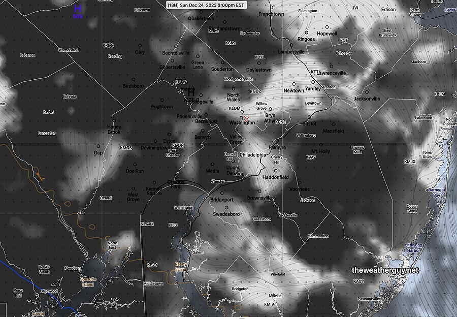
It appears that these current mixed/changeable cloud conditions will remain, but some areas in Bucks and northern Montgomery counties may see (brief )periods of sun by mid afternoon, while southern areas (Chester, Delaware, Philadelphia counties) will see mostly cloudy skies perhaps with a one or two more sprinkles late afternoon. This is a lower than average confidence forecast.

Christmas eve should be dry. Monday starts cloudy but with more breaks of sun, bright spots by afternoon. Mild.

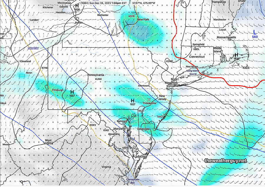
Sunday Forecast Update

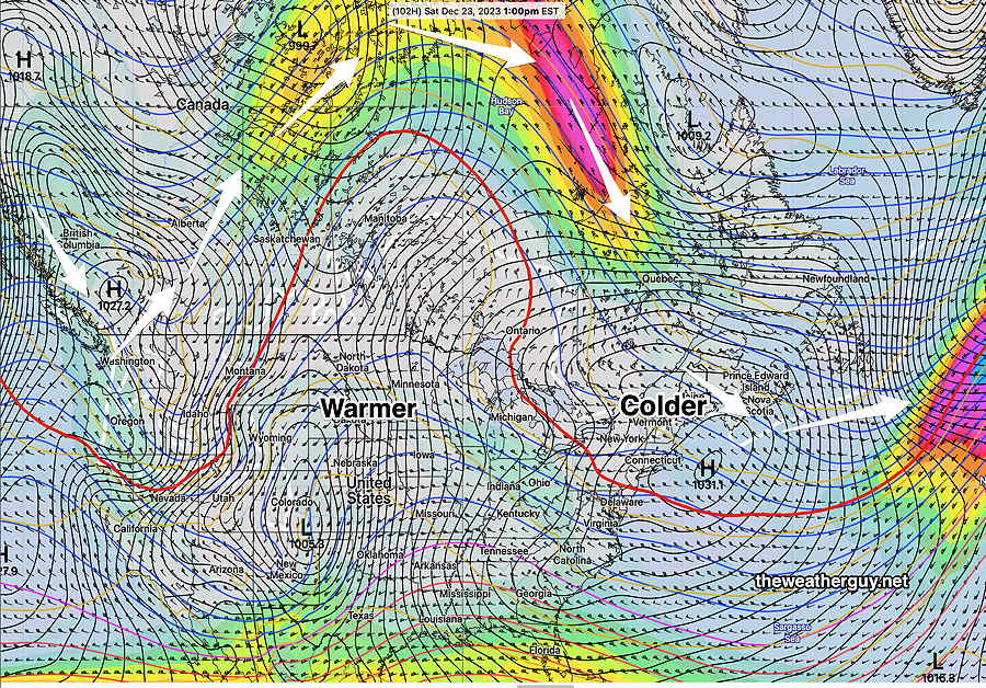
Posted Saturday 12/23 @ 4:48 PM — It looks like the warm front will remain quasi-stationary to our south. It’s increasingly likely that fog, drizzle and intermittent very widely scattered light sprinkles are possible late tonight into Sunday morning. Additionally, most models maintain considerable cloudy conditions (perhaps with some bright spots, partial clearing) with widely scattered sprinkles during the afternoon and into Sunday evening.

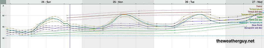
High temperatures will be on a gradual upswing towards over 50º by Monday—

NBM meteogram for Blue Bell, PA – temperature/dewpoints Sunday through early Wednesday. (Click on image for a larger view.)

Unfortunately, these same conditions may remain with us through Monday, perhaps with more occasional bright spots and periods of partial clearing, especially in the afternoon.


Weekend Weather Forecast Update

Posted Saturday 12/23 @ 9:32 AM — There isn’t much change in the forecast; we have an almost stationary warm front with moisture over-riding colder air at the surface. For today, Saturday, this low and mid level cloudiness hangs tight. A few models have some breaks of sun and some bright spots, but those periods of brightness haven’t occurred this morning. No rain during the daytime.

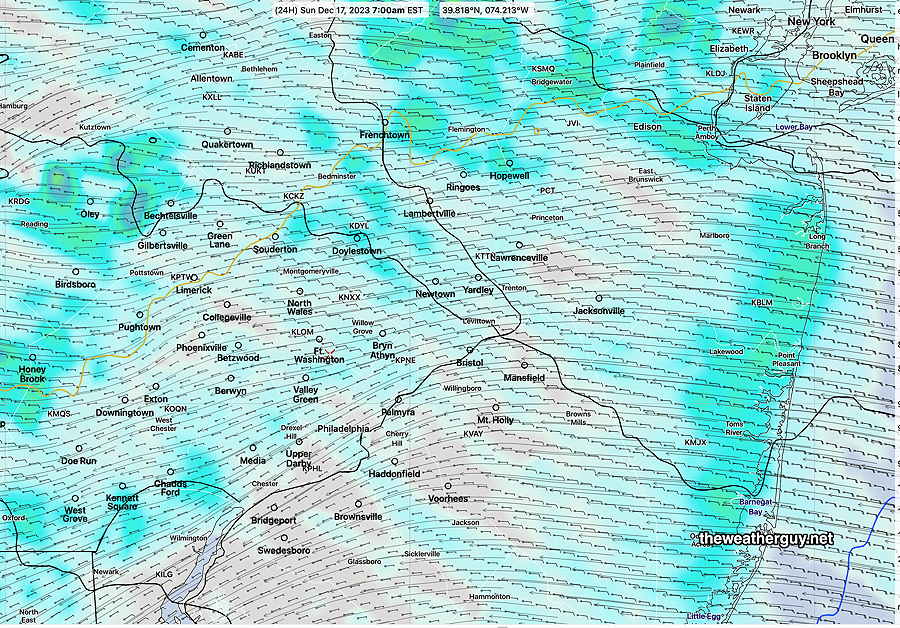
Fog, drizzle and very intermittent light sprinkles possible late tonight into Sunday. Here’s how the NAM-NEST depicts the clouds and sprinkles—

Today’s 06z NAM-NEST clouds (black-grey) and drizzle/sprinkles at 7 AM Sunday morning. (Click on image for a larger view.)

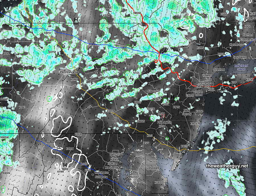
The clouds and light sprinkles continue on and off through the day Sunday, although much of the activity will be to our north. The same is expected Sunday evening into early Monday morning.

We may see some sun in the afternoon Monday.


Weekend Weather Forecast

Posted Friday 12/22 @ 3:30 PM — I’ve reviewed many models for this forecast. There remains varying model guidance on the showers for Sunday, but it does look like we’ll see some light showers/drizzle in the morning and even the afternoon, according to the latest NAM-NEST. Much of the forecast hinges on the movement of a warm front that may get hung up over our area.

Saturday

Some sun and clouds in the morning. Increasingly cloudy during the afternoon with cloudy conditions late afternoon.

High temperature 46º ( NBM model— location Blue Bell, PA)
High temperature 48º ( NBM model— location Philadelphia, PA)
uncertainty ± 1.1º (higher than usual confidence)

Sunday

Cloudy with a chance of light widely scattered showers/sprinkles/drizzle both during the day and into the evening.

High temperature 48º ( NBM model— location Blue Bell, PA)
High temperature 50º ( NBM model— location Philadelphia, PA)
uncertainty ± 1.2º (higher than usual confidence)

Christmas Eve– Cloudy, damp, some sprinkles possible, but mild with temperatures in the mid 40s.

Monday

Depending upon the movement of the warm front, we may see some sun, but low clouds look likely.

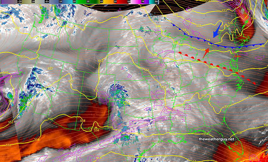
Weekend Forecast Preview

Previously Posted Fri 10:12 AM —

A very slow moving low pressure system in the central US won’t get here until next Tuesday and Wednesday. A slow moving warm front will move north Saturday through Sunday with considerable cloudiness both days.

Current(Friday morning) satellite water vapor image with superimposed RAP model 500-1000 mb thickness lines (yellow), Mean Sea Level Pressure isobars (black contours, potential vorticity (fine white contours), and superimposed MRMS RADAR. A building ridge will slowly push a warm front (red) over our area over this weekend. (Click on image for a larger view.)

Saturday just looks cloudy, with showers not making it into the Philadelphia area and surrounding counties.

Those of you following my forecasts from earlier this week know that there’s been uncertainty regarding the possibility of light showers from this warm front late Saturday into Sunday, with the ECMWF being consistent with light showers early Sunday in our immediate area.

The forecast has moved into the forecast range of the higher resolution models (NAM-NEST, HRDPS, HRRR and experimental RRFS). Most of this shower/drizzle activity stays in western Chester and Montgomery counties and northern Bucks counties, but the NAM-NEST (and “experimental” RRFS) does bring some light drizzle/showers here on Sunday morning with early fog in the same areas and even some light sprinkles early Sunday afternoon.

The Canadian RGEM is less on-board with showers and has clearing in the afternoon Sunday. So there’s still uncertainty in the forecast, but I’m leaning towards light sprinkles early Sunday followed by clearing by mid afternoon.

I’ll be reviewing the models again later today. Check back late this afternoon.